Viajá con Gus
Home › Somalia › Cal Madow and the Daallo forest
Cal Madow and the Daallo forest
🇸🇴 Somalia · Somaliland: the coast and the northern mountains

Cal Madow and the Daallo forest

🪪 What do I need to enter Somalia?Pick your citizenship and we tell you the visa, the days and the paperwork, with the official source.

By leaving your email and citizenship you agree to receive the documents you asked for and weekly travel news. You can unsubscribe whenever you want. How we handle your data.
Jump to what you need
📌What it is
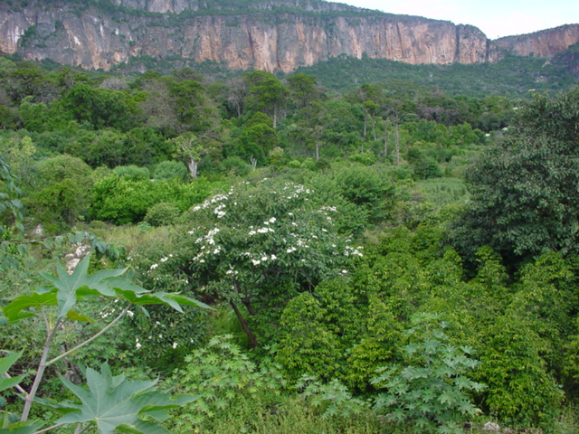
Cal Madow (also spelled Calmadow or Al Mado, “the black mountain”) is the mountain range in the northeast of the Horn of Africa: a limestone and gypsum escarpment that rises abruptly from the coastal plain of the Gulf of Aden, in the Sanaag region. Its highest point is Mount Shimbiris, at around 2,400 to 2,460 metres depending on the source, the highest in Somaliland and in all of Somalia. On its northern face, fed by the mist rising from the sea, the Daallo forest survives: a relict cloud forest with thousand-year-old junipers, frankincense and dragon's blood trees, surrounded by semi-desert.
📌Location and access
The Daallo forest is less than an hour's drive north of Erigavo (Ceerigaabo), the capital of the Sanaag region, at around 1,786 metres above sea level, and very close to the foot of Shimbiris. Erigavo can be reached by the Burao-Erigavo road —known as the Siilaanyo road— or by tracks from Bosaso, and it has a small airport (ERA) with a compacted gravel runway of about 2,000 metres. All access requires a 4x4 and a local guide.
📌SAFETY: read carefully
Important warning, AND DIFFERENT FROM THE REST OF SOMALILAND. Cal Madow and Erigavo are in the Sanaag region, which is NOT one of the three exceptions in the British FCDO advice. The Foreign Office advises against all travel to Somalia, including Somaliland, except to the Awdal, Maroodi Jeex and Sahil regions, for which it advises only against non-essential travel (June 2026 version): Sanaag falls into the most restrictive category, “advises against all travel”. The US Department of State keeps Level 4, “Do Not Travel”, for all of Somalia (14 May 2025). The reason is concrete: Sanaag is disputed between Somaliland, Puntland and, since 2023, the SSC-Khatumo administration, and there was fighting in Erigavo itself in December 2024 and in Jiidali, in eastern Sanaag, in January 2025. This is NOT Hargeisa or Berbera: the situation is fluid and access is conditional.
📅Altitude and climate
Erigavo sits at 1,786 metres and is one of the coolest towns in all of Somalia: average monthly temperatures of roughly 15 to 20 °C, and lows that drop below zero in some months. The summit of Daallo records around 650 mm of rain a year, and figures of 750-850 mm are cited for the wettest parts of the massif, topped up by the mist and drizzle rising from the sea. Bring proper warm clothes: the idea of being cold in Somalia surprises everyone.
📌Best time to go
The most sensible window is November to February, the cool, dry season, when the tracks are passable and the approach along the coast is bearable. The rains, which are fairly generous here by regional standards, are concentrated in the gu (April-June) and dayr (October-November) seasons and can leave mountain roads impassable. For birdwatching, the cool season also coincides with the passage of migrants.
📌Why it matters ecologically
Daallo is the largest and most accessible relict of the Somali montane xeric woodland, an ecoregion confined to an escarpment of about 300 kilometres running parallel to the north coast. Around a thousand plant species are recorded in the massif, about 200 of them endemic, and a botanical expedition led by Mats Thulin in 1995 described around eight species new to science. Some of the forest's trees are more than a thousand years old. It is recognised as an Important Bird Area (IBA) by BirdLife International.
📌Star wildlife
For birders, Daallo is the best place in the Horn of Africa for a handful of endemics that are almost impossible to see anywhere else: the Warsangli linnet (Linaria johannis), the Somali thrush (Turdus ludoviciae), the Somali or Socotra golden-winged grosbeak, Archer's francolin and Archer's buzzard. Among mammals, the massif and its surroundings are home to the dorcas gazelle, the beira —a dwarf antelope endemic to the Horn— and other species with very restricted ranges.
📌Permits and logistics
A Somaliland visa is mandatory —a Somali one won't do— and an armed SPU escort is required for any movement outside the cities (US$ 15-40 per day according to Wikivoyage). For Sanaag, on top of that, actual authorisation depends on the situation at the time: you need to check in Hargeisa with the Ministry of Tourism and the police, and hire an operator with experience in the area. This is not a destination to improvise or do on your own.
📌Duration
Allow at least three or four days from Hargeisa just to get there and back: Erigavo is about 500 kilometres by road from the capital, and the drive along the Burao-Erigavo route takes most of a day. With five or six days you can do the Daallo forest at an easy pace, head up towards Shimbiris and devote full mornings to the birds.
💱 SOS exchange rate
Loading rate…
🌤️ Weather in Cal Madow and the Daallo forest
Loading weather…

There is a forest in Somalia. It sounds like a mistake, but it's true: on the Cal Madow escarpment, in the northeastern corner of Somaliland, the mist rising from the Gulf of Aden feeds a strip of evergreen juniper forest where some trees are over a thousand years old. It's called Daallo, it's less than an hour from Erigavo, and from its edge you can see the sea two thousand metres below.

It is one of the most biologically valuable and least studied places in Africa. Around a thousand plant species, some two hundred of them endemic; junipers, box, the boswellias that yield the frankincense that made this coast famous since the time of the pharaohs, and even a relative of the dragon's blood tree. And a bird list that brings ornithologists from the other side of the world: the Warsangli linnet, the Somali thrush, Archer's francolin and Archer's buzzard, the golden-winged grosbeak.

It also needs to be said plainly from the start: this is the most difficult and most sensitive of all Somaliland's destinations. Cal Madow is in the Sanaag region, disputed between Somaliland, Puntland and the SSC-Khatumo administration, with fighting in Erigavo in December 2024 and in eastern Sanaag in January 2025. It does not share the relatively stable status of Hargeisa, Berbera or Laas Geel, and foreign ministries treat it differently. This guide covers what is there, how to get there and what you need to know before even considering it.

📖 History of Cal Madow and the Daallo forest

Cal Madow is a limestone and gypsum escarpment pushed up by the tectonics that opened the Gulf of Aden and the Red Sea, leaving the Horn of Africa with a mountain range right by the sea and a desert plain at its feet. Millions of years ago, that geography created a moisture trap: moisture-laden winds from the gulf hit the northern wall, condense and feed a cloud forest that survived in isolation while the regional climate dried out. The result is a biological island with a very high level of endemism, the largest relict of the Somali montane xeric woodland. For people, these mountains were for millennia the source of the frankincense and myrrh that supplied Egypt, Arabia, Greece and Rome —the legendary “land of Punt” and the “coast of aromatics” of classical sources— and the territory of the Warsangli clan, which gave its name to one of the most sought-after birds here. Scientifically, the massif was explored very late: a botanical expedition led by Mats Thulin in 1995 described around eight plant species new to science and recommended protecting the forest as a natural monument. Today Daallo is recognised as an Important Bird Area by BirdLife International and as a protected area by the Somaliland authorities, but deforestation for firewood and charcoal, overgrazing and the political dispute over the Sanaag region keep it in a fragile state.

Read the full history ↓

🏛️ Cal Madow and the Daallo forest is in Somaliland: the coast and the northern mountains

From the Gulf of Aden to the 2,400 metres of Cal Madow: ports that appear in the Greek Periplus, Zeila's mosque of the two qiblas, an airstrip built by the Soviets and the world's last great frankincense forest.

Read the history of Somaliland: the coast and the northern mountains →

🗺️ What to see

1
The Daallo cloud forest
The heart of the place: an evergreen forest dominated by junipers (Juniperus procera, dayib in Somali) and box, with specimens over a thousand years old, wrapped in mist for much of the day. It is the largest and most accessible relict of the Somali montane xeric woodland, an ecoregion confined to about 300 kilometres of escarpment. Walking among those trunks, with lichens hanging and the smell of juniper, is the central experience of the trip.
2
The escarpment edge and the view over the Gulf of Aden
From the top of the escarpment, the wall drops sharply to the coastal plain and you can see the Gulf of Aden two thousand metres below. It is one of the most spectacular views in East Africa and practically nobody knows about it. At dawn, with the mist climbing up the wall, it's even better.
3
Mount Shimbiris
The roof of Somaliland and of all Somalia, at around 2,400 to 2,460 metres depending on the source, a short distance west of Erigavo. The ascent isn't technical, but getting close requires a 4x4 and a local guide; the interest lies as much in the summit as in the way the vegetation changes with altitude.
4
Endemic birds: the Warsangli linnet
The most sought-after endemic in the Horn of Africa, with a tiny range in these mountains. Its name comes from the Warsangli clan, traditionally settled in the region. Daallo is, beyond dispute, the best place in the world to see it, and it's the reason operators such as Birdquest include Somaliland in their tours.
5
Somali thrush, golden-winged grosbeak and Archer's francolin
The rest of the quartet of specialities: the Somali thrush (Turdus ludoviciae), the Somali or Socotra golden-winged grosbeak, Archer's francolin and Archer's buzzard. All have ranges restricted to the forest and upland scrub of northeastern Somalia. Early mornings in the forest clearings are the time to look.
6
Frankincense trees (Boswellia)
On the slopes and the escarpment grow the boswellias that produce frankincense —beeyo and maydi in Somali— which made this coast famous since ancient Egypt. They are still tapped in the traditional way, and the resin is still a source of income for local families. Seeing a frankincense tree in production, with tears of resin hardening on the bark, connects the landscape to three thousand years of trade.
7
Dragon's blood and endemic flora
The botanical rarities of the massif include Martian-looking succulents and relatives of the dragon's blood tree, along with nearly two hundred plant species endemic to these mountains. Mats Thulin's 1995 expedition described around eight species new to science here. It is one of the least studied biodiversity hotspots on the continent.
8
Myrrh and medicinal plants
Besides frankincense, the massif produces myrrh and a very broad traditional pharmacopoeia: many of the forest's plants have medicinal uses recognised by local communities. A local guide can explain uses you won't find in any book.
9
Erigavo (Ceerigaabo)
The capital of the Sanaag region, at 1,786 metres, is the essential logistics base and one of the coolest towns in Somalia: monthly averages of 15 to 20 °C and lows below zero in some months. It's a mountain town of markets and livestock, with around 30,000 inhabitants in the town itself according to 2013 estimates. It is also a sensitive spot: it saw fighting in December 2024.
10
Mountain wildlife: beira and dorcas gazelle
The mammals of the massif and its surroundings include the beira, a dwarf antelope endemic to the Horn of Africa and very hard to see, and the dorcas gazelle, along with other species with restricted ranges. This wildlife is elusive and in decline: don't count on seeing it, but ask the herders.
11
Pastoral life on the escarpment
The herding families of Sanaag move through these mountains with goats, sheep and camels according to the rains, and harvest frankincense and wood. They are also the ones who know every trail and every waterhole. The relationship with them is the key to any visit and also the crux of the conservation problem: the forest is shrinking due to the extraction of firewood and charcoal and to overgrazing.
12
The Burao-Erigavo road
The so-called Siilaanyo road, which links Somaliland's second city with Erigavo, is a long journey in itself across the plateau and inland passes. It is the most common way in, and its condition shapes all the planning.
📶I have never landed without internet. I arrive and my phone connects to the strongest network in the country I am visiting: I can say I landed, sort out transport, book tours and keep posting, at a seriously good price. I always use the Maya eSIM — check their plans by clicking the banner.See plans →Maya Mobile eSIM — download, install, go
What nobody tells you

💵 Prices

Tickets

TypePrice
Acceso al bosque de DaalloThere is no ticket office and no published official rate. The area is listed as a Somaliland reserve and protected area, but management in practice is local: it is agreed with the guide and the community. Check in Erigavo or with the Ministry of Tourism in Hargeisa (2026)
Escolta SPUUS$ 15-40 per day according to Wikivoyage, negotiable; mandatory for foreigners outside the cities. In Sanaag, authorisation also depends on the security situation at the time (2026)
Visado de SomalilandiaUS$ 60-61 on arrival at Hargeisa airport for eligible nationalities (Wikivoyage, November 2025); around US$ 70-100 in Addis Ababa depending on the source, US$ 60 in Djibouti and £ 30 in London (Against the Compass, 2026)
Guía local y porteoNo published rates: negotiated in Erigavo. Essential, both for finding your way and for the relationship with the escarpment communities (2026)
🔄 updated monthlyOfficial / reference values · double-check when buying

Activities and tours

Walks in the Daallo forest
PriceNo fixed rate: hire a local guide in Erigavo
DurationHalf day to full day
OperatorLocal guides from Erigavo / operator hired from Hargeisa
Endemic birdwatching
Duration2 to 4 days to cover the specialities properly
OperatorBirdquest and other birding operators; local guides
Price
No local price list. Specialised international tours, such as Birdquest's, include Somaliland in itineraries combined with Djibouti; ask for a quote
Ascent of Mount Shimbiris
PriceNo published rate; requires a 4x4 and a guide
DurationFull day from Erigavo
OperatorLocal guides with vehicle
Camping on the escarpment
PriceNo fee; you need to bring your own gear
Duration1 or more nights
Operator
Self-organised with a local guide. There are no established campsites or services
Visit to the frankincense trees and harvesting families
PriceTo be agreed; it's customary to buy resin directly from the producers
DurationHalf day
OperatorLocal guide
Full tour from Hargeisa
Duration5 to 8 days round trip from Hargeisa
OperatorSpecialised agencies
Price
No generally published prices: ask agencies with experience in eastern Somaliland for a quote. Allow for a 4x4, driver, guide, escort and several days
🔄 updated monthlyOfficial / reference values · double-check when buying

🚌 How to get there and distances

Getting around

4x4 with driver and guide
PriceNegotiated per day; the only realistic way to get around
DurationUnder 1 h from Erigavo to the Daallo forest
Notes
Mountain tracks, with demanding stretches and no signposting. After rain they can become impassable. Never go without a local guide
On foot through the forest and the escarpment
Free
DurationHalf day to full day
Notes
There are no marked trails or infrastructure. Hiking boots, water, warm clothes (it gets genuinely cold) and a guide are a must. The mist disorients you fast
Shared transport to Erigavo
PriceLocal fare; no fixed schedules or reliable frequencies
DurationAlmost a full day from Burao
Notes
It exists, but for a foreigner it's impractical because of the escort requirement and the changing situation in Sanaag
Flight to Erigavo (ERA)
PriceIrregular frequencies and no stable published fares
DurationShort flight from Hargeisa
Notes
The airport has a compacted gravel runway of about 2,000 metres. Operations depend on circumstances: check before counting on this option
🔄 updated monthlyOfficial / reference values · double-check when buying

How to get there

Hargeisa → Burao → Erigavo (Siilaanyo road)
Negotiable; no published fares
Airlines / operatorsHired 4x4 with driver; also shared transport
DurationPractically a full day for about 500 km
Erigavo → Daallo forest
Negotiated in Erigavo
Airlines / operators4x4 with local guide
DurationUnder 1 h
Erigavo → Shimbiris
Negotiable
Airlines / operators4x4 with local guide
DurationFull day round trip
Bosaso (Puntland) → Erigavo
No published fares
Airlines / operatorsOverland transport on tracks
Duration
Long day. A possible route on paper, but it crosses disputed territory with armed groups present: not a recommended option for a visitor
Flight Hargeisa → Erigavo (ERA)
No stable published fares
Airlines / operatorsRegional operators, with irregular frequencies
DurationShort flight
🔄 updated monthlyOfficial / reference values · double-check when buying

🏨 Where to stay

No exact prices: a scale from $ (budget) to $$$$$ (luxury), with 2-3 options per category.

Hotels in Erigavo
Price$$$$$
Recommended options
The capital of Sanaag has simple hotels aimed at traders and officials, with no online booking and no reliably published rates. Payment is in cash. It's the only base with accommodation in the area: expect the basics and scarce hot water —and in Erigavo, at 1,786 metres, you'll feel the cold water
Camping in Daallo
Price$$$$$
Recommended options
There are no lodges, huts or established campsites in the forest. Anyone wanting to sleep up there has to bring a tent, a cold-rated sleeping bag, food and water, and organise it with the local guide. It's the only way to be in the forest at dawn, which is when the birds appear
Base in Burao
Price$$$$$
Recommended options
On the way from Hargeisa, Burao —Somaliland's second city— is the logical stopover, with modest hotel options in a rough range of US$ 15-40 a night. No reliable published rates
Base in Hargeisa
Price$$$$$
Recommended options
The starting point for any expedition: Maansoor Hotel from about US$ 58 according to its own rate sheet (2026), Ambassador and Damal in the same bracket, and budget options such as the Maamu Hotel at around US$ 20-25 (Against the Compass, 2026)

🍴 Where to eat

Comedores de Erigavo
Price$$$$$
Options / signature dish
Spiced rice, goat, Somali-style pasta, canjeero and tea with cardamom, in simple eateries. As a general reference for the country, a basic meal costs around 10,000-20,000 Somaliland shillings (Against the Compass, 2026), a dollar or two
Autoabastecimiento para la montaña
Price$$$$$
Options / signature dish
Essential. There is absolutely nothing in the forest: bring water for several days, non-perishable food, nuts and electrolyte salts. Stock up in Burao or Erigavo, which is where decent supplies run out
Carne y leche de camello
Price$$$$$
Options / signature dish
In Sanaag herding is the economy, and camel milk — caano geel — is an everyday food as well as a gesture of hospitality. Accepting it is the right thing to do; if you have a sensitive stomach, keep that in mind
Té y descanso en la ruta
Price$$$$$
Options / signature dish
The tea houses in the villages along the Burao-Erigavo road are the only stops on a very long journey: shaah with cardamom, biscuits and sambusas for a few cents

📖 History of Cal Madow and the Daallo forest

Origins, formation and what the sources say.

How the mountain was made: the Gulf of Aden rift

Cal Madow exists as a direct result of one of the great fractures in the Earth's crust. For around thirty million years, the Arabian plate has been pulling away from the African plate. That opening created the Red Sea and the Gulf of Aden, and it lifted the edges of the rift into steep escarpments on both sides. On the African side, the result is a mountain range pressed right up against the sea: a wall that rises almost all at once from the coastal plain of the Gulf of Aden to more than two thousand metres.

The rock is limestone and gypsum. These are marine sedimentary rocks laid down long before, then lifted by tectonics and carved over time by water and wind. The range as a whole is known as Cal Madow, “the black mountain”, and some sources treat it as part of the Ogo mountains or the eastern Golis. It runs parallel to the coast and peaks at Mount Shimbiris, at around 2,400 to 2,460 metres depending on the source. That makes it the highest point in Somaliland and in all of Somalia.

Without anyone planning it, that shape created a moisture trap. Winds coming off the gulf arrive loaded with vapour, hit the northern wall of the escarpment and are forced upwards. As they rise they cool, and as they cool they condense. The result is fog, drizzle and rainfall estimated at about 650 mm a year on the summit at Daallo, with 750-850 mm cited for the wettest parts of the massif. In absolute terms these are modest figures, but they are extremely high for a country where the national average is a few hundred millimetres and where drought shapes everyday life.

en.wikipedia.org · Cal Madowen.wikipedia.org · Daallo Mountain

A biological island: the forest that outlived the desert

During the African Humid Period, between nine thousand and three thousand years ago, much of North Africa and the Horn was far greener than it is today, with wooded savannahs, lakes and rivers. When the climate dried out, the forest pulled back to the few places that still got enough moisture. In the northeastern Horn of Africa, that place was the northern face of Cal Madow.

That is where the Daallo forest was left stranded. It is a strip of evergreen forest dominated by African juniper (Juniperus procera, dayib in Somali) and boxwood, with some trees more than a thousand years old. Ecologists call this a relict: a fragment of an ecosystem that was once widespread and now survives in isolation. Daallo is the largest and most accessible relict of the Somali montane xeric woodlands, an ecoregion confined to an escarpment of about three hundred kilometres that runs inland from the northern coast.

Isolation has a predictable consequence: evolution goes its own way. When a population is cut off from the rest of its species for thousands of years, it drifts on its own. That is why Cal Madow is a storehouse of endemic species. Around a thousand plant species have been recorded in the massif, and some two hundred of them exist nowhere else on the planet. The oddities include succulents that look like they came from another world, relatives of the dragon's blood tree (the same lineage behind the famous specimens on Socotra, the Yemeni island just across the gulf), and the frankincense-producing boswellias.

The wildlife follows the same pattern. The most sought-after birds here have tiny ranges: the Warsangli linnet (Linaria johannis), the Somali thrush (Turdus ludoviciae), the Somali or Socotra golden-winged grosbeak, Archer's francolin and Archer's buzzard. Among mammals, the massif and the land around it are home to the beira, a dwarf antelope endemic to the Horn of Africa, and the dorcas gazelle. BirdLife International recognises the site as an Important Bird Area.

en.wikipedia.org · Cal Madowbradtguides.com · Daallo escarpment

The coast of aromatics: three thousand years of frankincense

Long before anyone cared about endemic species, these mountains were famous in the ancient world for one very specific thing: resin. The boswellias growing on the escarpment produce frankincense (beeyo and maydi in Somali), and the commiphoras produce myrrh. Both resins were burned in temples and used in medicine and embalming, and they were worth their weight in gold.

This is the coast that classical sources called “the coast of aromatics”. It appears in the Periplus of the Erythraean Sea, the first-century Greek sailing manual, as the source of the best frankincense available. Even earlier, the Egyptians sent expeditions to the legendary land of Punt to bring back frankincense, myrrh, ebony and gold. Where exactly Punt was is still debated, but the Horn of Africa is one of the main candidates. Greeks, Romans, Persians and Arabs traded here for centuries, and the incense routes linked these mountains with the Mediterranean and with Asia.

The trade never fully stopped. Families on the escarpment still tap the trees the traditional way: they cut into the bark, the resin seeps out and hardens into “tears”, and it is collected weeks later. It is one of the few sources of cash income in the region, and one of the reasons local people have a direct interest in keeping the forest standing.

This is also the land of the Warsangli clan, traditionally settled in eastern Sanaag and along the coast, who gave their name to the best-known bird in these mountains. Nomadic herding, resin gathering and coastal trade have always been the economy of Cal Madow, and they still are.

Identifying the land of Punt from Egyptian sources with the Horn of Africa is the most widely held hypothesis, but not everyone agrees: other authors place it on the Sudanese-Eritrean coast or in southern Arabia. What nobody disputes is that the aromatic resins of northern Somalia supplied the markets of the Mediterranean and Asia from ancient times.
savefrankincense.org · Biodiversityen.wikipedia.org · Cal Madow

Late science: what we still don't know

Unlike almost any other biodiversity hotspot in the world, Cal Madow has barely been studied. The reasons are obvious: difficult access, no infrastructure, decades of war and state collapse in Somalia, and a lack of well-funded local scientific institutions.

The most cited milestone is a botanical expedition in 1995 led by the Swedish botanist Mats Thulin, a specialist in the flora of the Horn of Africa. He travelled across the massif and described around eight plant species new to science in a single trip. That says less about the team's skill than about the state of knowledge: in 1995, in a mountain range spanning an entire country, you could still find eight unknown species in one field season. The expedition's report recommended declaring the forest a natural monument and protecting it from overexploitation and human-caused destruction.

Since then, the work has been patchy: wildlife surveys backed by conservation organisations, antelope counts such as the one documented by David Mallon and Abdi Jama for the IUCN, BirdLife reports and occasional campaigns by organisations working to conserve frankincense. Practically everything is still missing: full inventories, studies of forest dynamics, population monitoring, detailed mapping.

Meanwhile, the forest is shrinking. The threats identified are the usual ones, and all of them are local: cutting firewood and making charcoal, overgrazing by goats that stops the junipers from regenerating, over-tapping of resin and population pressure. Daallo is listed as a protected area under Somaliland law and as a BirdLife Important Bird Area, but actual management on the ground is minimal.

en.wikipedia.org · Cal Madowportals.iucn.org · Rep 2015 011

Sanaag: the disputed region where the forest stands

Any conversation about visiting Cal Madow inevitably ends up in politics. The massif lies in the Sanaag region, whose capital is Erigavo (Ceerigaabo), at 1,786 metres above sea level and one of the coolest towns in all of Somalia. And Sanaag is disputed territory.

Somaliland claims the region because it lay within the borders of the former British protectorate, which is the legal basis for its claim to independence since 1991. Puntland, the federal state in northeastern Somalia, claims it on clan grounds: part of Sanaag's population belongs to clans linked to Puntland. And since 2023 there has been a third player: the SSC-Khatumo administration, which emerged after the Las Anod conflict, rejects Somaliland's control over the Sool, Sanaag and Cayn regions and is seeking autonomy within Somalia.

The dispute is not theoretical. In December 2024 there was fighting in Erigavo itself between Somaliland forces and SSC-Khatumo militias; Somaliland won and kept control of the town. In January 2025, Somaliland forces took Jiidali, in eastern Sanaag. Routes between these regions and the rest of Somaliland have been disrupted since 2023.

For travellers, this means a clear difference from Somaliland's other destinations. The British Foreign Office exempts only Awdal, Maroodi Jeex and Sahil (that is, Zeila, Hargeisa, Laas Geel, Berbera and Sheikh) from its highest warning level, and for those it advises against all but essential travel. Sanaag is not exempted: for Sanaag, the advice is not to travel at all. The US State Department, for its part, keeps all of Somalia at Level 4.

It is a situation sadly in keeping with the rest of the place's history: one of the most biologically valuable and least-known forests in Africa, in a corner of the world where sovereignty is contested, with no possibility of international protection and only a handful of scientists who have passed through in the last thirty years. Meanwhile, the forest keeps doing what it has done for thousands of years: catching the fog that rises from the Gulf of Aden.

gov.uk · Somaliaen.wikipedia.org · Battle of Erigavo

📚 Bibliography

  • Wikipedia (EN) — “Cal Madow”: https://en.wikipedia.org/wiki/Cal_Madow
  • Wikipedia (EN) — “Daallo Mountain”: https://en.wikipedia.org/wiki/Daallo_Mountain
  • Wikipedia (EN) — “Erigavo”: https://en.wikipedia.org/wiki/Erigavo
  • Wikipedia (EN) — “Sanaag”: https://en.wikipedia.org/wiki/Sanaag
  • Wikipedia (EN) — “Battle of Erigavo” (December 2024): https://en.wikipedia.org/wiki/Battle_of_Erigavo
  • Wikipedia (EN) — “Battle of Jiidali (2025)”: https://en.wikipedia.org/wiki/Battle_of_Jiidali_(2025)
  • Bradt Guides — “Daallo Escarpment” (Somaliland): https://www.bradtguides.com/destinations/africa/somaliland/daallo-escarpment.html
  • Journeys by Design — “The Daallo Forest, Somaliland”: https://journeysbydesign.com/destinations/somaliland/daalloo
  • Save Frankincense — “Biodiversity: Cal Madow”: https://www.savefrankincense.org/biodiversity
  • David P. Mallon and Abdi A. Jama (IUCN) — “Current Status of Antelopes in Somaliland”: https://portals.iucn.org/library/efiles/documents/Rep-2015-011.pdf
  • Birdquest — “Somaliland & Djibouti Birding Tours” (Daallo endemics): https://www.birdquest-tours.com/birding-tours/somaliland-djibouti/
  • EUAA — “Somalia Security Situation 2025: Sool, Sanaag and SSC-Khatumo”: https://www.euaa.europa.eu/coi/somalia/2025/security-situation/27-sool-sanaag-and-ssc-khatumo/273-sool-sanaag-and-ssc-khatumo-checkpoints-and-road-security

❓ Frequently asked questions

Is it safe to go to Cal Madow? Is it the same as going to Hargeisa?+
No, and this is the most important distinction in the whole guide. Hargeisa, Laas Geel, Berbera, Sheikh and Zeila are in Maroodi Jeex, Sahil and Awdal, the three regions that the British FCDO exempts from its highest level of warning. Cal Madow and Erigavo are in Sanaag, which is NOT exempt: for Sanaag the FCDO advises against all travel (June 2026 version), just as it does for the rest of Somalia. The reason is specific: the region is disputed between Somaliland, Puntland and the SSC-Khatumo administration, and there were clashes in Erigavo itself in December 2024 and in Jiidali, in eastern Sanaag, in January 2025. If you are considering this trip, find out about the current situation from up-to-date sources and from an operator who works regularly in the area, and accept that the plan may fall through.
Is there really a forest in Somalia?+
Yes, and a remarkable one. The northern face of the Cal Madow escarpment catches the moisture rising from the Gulf of Aden and condenses it into fog and drizzle, which sustains an evergreen forest of juniper and boxwood with trees more than a thousand years old. Figures of around 650 mm of annual rainfall are cited for the summit of Daallo, and 750-850 mm for the wettest parts of the massif — extremely high by regional standards. It is the largest and most accessible remnant of Somali montane xeric woodland, an ecoregion confined to some 300 kilometres of escarpment.
Which birds can you see, and when?+
The four or five specialities that bring birdwatchers from the other side of the world are the Warsangli linnet (Linaria johannis), the Somali thrush (Turdus ludoviciae), the Somali or Socotra golden-winged grosbeak, Archer's francolin and Archer's buzzard. Daallo is recognised as an Important Bird Area (IBA) by BirdLife International and is the best known site for several of them. The best time is early morning, in the forest clearings; the best season is the cool, dry period from November to February.
How do you get there and how long does it take?+
By the Burao-Erigavo road (the Siilaanyo), from Hargeisa: about 500 kilometres that take practically a full day, usually with an overnight stop in Burao. From Erigavo, the Daallo forest is less than an hour away by 4x4. There is also an airport at Erigavo (ERA), with a compacted gravel runway of about 2,000 metres and irregular services. The route from Bosaso, in Puntland, exists on paper but crosses disputed territory and is not advisable.
Do I need to bring warm clothes?+
Yes, and many people don't expect it. Erigavo sits at 1,786 metres and is one of the coolest towns in all of Somalia, with monthly averages between 15 and 20 °C and lows below freezing in some months; in the Daallo forest, with fog and wind, it feels considerably colder. If you plan to camp, you need a cold-weather sleeping bag. Arriving from Berbera, where it is over 40 °C, and ending up shivering on the escarpment is the standard experience of this trip.
Is there accommodation in the forest?+
No. There are no lodges, huts or official campsites: the only way to sleep up there is to camp with your own gear, organised with your local guide. The base with hotels is Erigavo, with simple establishments, no online booking and cash payment. Nor are there rescue services or proper medical care in the area: any serious problem means a very long evacuation.
What about the frankincense?+
These mountains are one of the world's historic frankincense and myrrh producing areas: resin from the boswellia trees growing on the escarpment supplied ancient Egypt, Arabia, Greece and Rome, and this is the coast that classical sources called “the coast of aromas”. The trees are still tapped in the traditional way, and it remains an important source of income for families on the escarpment. You can visit trees in production and buy resin directly from the harvesters; it is a purchase that makes sense, because the money goes to the people who look after the forest.
What is its conservation status?+
Fragile. The massif is home to around a thousand plant species, some 200 of them endemic — an expedition led by Mats Thulin in 1995 described about eight species new to science and recommended protecting the forest as a natural monument — but it suffers from deforestation for firewood and charcoal, overgrazing and pressure on frankincense production. Daallo is listed as a protected area in Somaliland and as a BirdLife IBA, but effective management is minimal and, like all the territory's heritage, it falls outside international mechanisms because of the lack of recognition. If you go, don't cut anything, don't camp inside the closed forest, don't make fires with local wood, and take all your rubbish with you.

More places in Somalia

GaroweCasco antiguo de Hamar Weyne y ShanganiHargeisaKismayoLaas GeelMogadiscio
See every place in Somalia →The history of Somalia →
Sources consulted (17)
Still planning?
Explore more destinations in Somalia
See all destinations →
Image credits
Photos from Wikimedia Commons, each under its own licence (CC BY, CC BY-SA or public domain). Open each file to see its author and licence.
Cal Madow forest