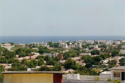
Kismayo is the gateway to Somalia's deep south. It is an Indian Ocean port near the mouth of the Juba River, the de facto capital of Jubaland and the main city of the country's greenest and most fertile region. It has pale sandy beaches, shipyards where wooden dhows are still built by hand, and a fish market that gets going before dawn. Thirteen kilometres away is Goobweyn, one of the most unusual landscapes in East Africa, where the river meets the ocean among palm trees, flamingos and cattle coming down to drink.
Kismayo also has one of the hardest recent histories in Somalia. It was the great prize of the south during the civil war. Al Shabaab controlled it from late 2006 until 2012, when a joint operation by the Somali army, the Ras Kamboni militias and Kenyan AMISOM forces retook it. Since 2013 it has been the seat of the Interim Juba Administration. Since then it has also been at the centre of a constant tug-of-war with the federal government in Mogadishu, which turned into armed clashes in December 2024.
This guide covers what Kismayo is and what it has been: the Zanzibari port, the Italian colony of Oltre Giuba, the city on the Juba. It does not play down the context. Every foreign ministry has Somalia at its highest alert level, and the deep south is the most exposed part of the country. This is not a travel recommendation. It is dated, sourced information to help you understand the place, so that anyone who has to go for work knows exactly what they are facing.
In the Middle Ages the lower Juba was part of the Ajuran Sultanate. It later came under the Geledi Sultanate, which controlled the caravan trade of southern Somalia. In the 19th century the coast came under Muscat and then the Sultanate of Zanzibar, and from 1895 it became part of British East Africa. After the First World War, the United Kingdom gave the northern part of Jubaland to Italy as a reward for joining the war on the Allied side. This created the Italian colony of Oltre Giuba, with Kismayo as its main city. Corrado Zoli governed it from 16 July 1924 to 31 December 1926, and the colony was merged into Italian Somaliland on 30 June 1926. Britain kept the southern half, which became the Northern Frontier District and is now part of Kenya. Kismayo became a Somali district at independence in 1960. Its port was built in 1964 with US assistance. The city fell during the civil war, was under Al Shabaab control from 2006 to 2012, and since 2013 has been the seat of the Jubaland administration.
Read the full history ↓Green, farming Somalia: the Juba valley, the Swahili islands of the Bajuni, the Rahanweyn of Baidoa and their Maay language, and the corner of the country where conflict and famine hit hardest.
Read the history of The deep south: Jubbaland and Bay (very unsafe areas) →No exact prices: a scale from $ (budget) to $$$$$ (luxury), with 2-3 options per category.
Origins, formation and what the sources say.
Everything in Kismayo starts with the river. The Juba (Jubba in Somali) is, along with the Shabelle, one of only two permanent rivers in Somalia. It rises in the Ethiopian highlands, flows south-east through the interior and reaches the Indian Ocean a few kilometres north of the city, at a spot called Goobweyn. In a country where dryness is the rule, this river corridor is the exception: gallery forest, fertile soil, grazing land and a density of life found nowhere else in the territory.
On that geographical base, a crossroads of worlds took shape very early on. By sea came the trade of the Indian Ocean, moving to the rhythm of the monsoon that linked the African coast with Arabia, Persia and India. Down the river and the inland routes came cattle, ivory, hides and the farm produce of the valley. The coast and the islands offshore were home to the Bajuni, a Swahili-speaking people of fishermen and sailors. Their language, Kibajuni, is a dialect of Swahili, and their settlements stretched across the archipelago that now bears their name.
In the Middle Ages, the lower Juba region belonged to the Ajuran Sultanate, the great Somali power that controlled the Shabelle and Juba valleys from the 13th to the 17th century through a system of wells, stone fortifications and water management. Later the Geledi Sultanate, based in Afgoye in the Shabelle valley, dominated the caravan trade of southern Somalia and held sway over this stretch of coast.
In the 19th century the maritime powers of the western Indian Ocean arrived. Between 1836 and 1861 the Sultanate of Muscat claimed parts of Jubaland. After that the coast fell within the orbit of the Sultanate of Zanzibar, which nominally ran the ports and collected customs duties through local governors. It was in this setting that Kismayo became an established port.
Kismayo's colonial history is different from the rest of Somalia's, and it explains much of the city's character. From 1895, the coast and the Juba hinterland were part of British East Africa, not Italian Somaliland. For three decades Kismayo was a British city, with the administration, trade networks and connections that came with it, looking as much towards Mombasa and Zanzibar as towards the Somali north.
The First World War redrew the map. Italy had joined the Allies in 1915 and, once the war was over, demanded territorial compensation in Africa. The United Kingdom ended up giving away the northern part of Jubaland, the part on the far side of the river from its interests in Kenya, as a reward for Italy's role in the war. The handover took place in 1924-1925 and created a short-lived and unusual territory: the Italian colony of Oltre Giuba, meaning "beyond the Juba", or Trans-Juba.
Oltre Giuba had just one governor, Corrado Zoli, who ran the territory from 16 July 1924 to 31 December 1926, with Kismayo as its main city. The colony was very short-lived. On 30 June 1926 it was absorbed into Italian Somaliland, and from then on Kismayo was simply one more city, if a strategic one, in Italy's colonial system in the Horn of Africa. The colony even issued its own postage stamps, now a curiosity for stamp collectors.
Britain kept the southern half of Jubaland, which was renamed the Northern Frontier District and became part of Kenya after Kenyan independence. That line drawn in the 1920s split Bajuni land in two and separated communities that shared a language, family ties and fishing routes. The effects of that partition are still felt today. Much of the border tension and the displacement of the Bajuni people in the 20th and 21st centuries goes back to that colonial border.
With independence on 1 July 1960 and the creation of the Somali Republic, Kismayo became a Somali district and the main urban centre of the deep south. The young republic invested in strategic infrastructure, and Kismayo's seaport was built in 1964 with US assistance. It was then, and still is, the cornerstone of the regional economy.
The port made the city the natural outlet for the whole lower Juba, a region whose farm output has no equal anywhere else in Somalia: bananas, maize, sesame and sugar cane, plus livestock from the interior. Live cattle exports to the Arabian Peninsula and coastal trade along the Indian Ocean gave Kismayo a particular energy.
Under Siad Barre's regime (1969-1991), the south received state investment in irrigated farming and in food processing tied to the Juba valley, as part of the scientific socialism the regime proclaimed. At the same time, the period's settlement and land redistribution policies reshaped the clan map of the region. They planted conflicts over land and access to the river that would erupt violently after 1991.
The Ogaden War against Ethiopia (1977-1978) and Somalia's defeat marked the start of the regime's decline. In the 1980s, economic crisis, harsher repression and clan fragmentation together paved the way for collapse. When the state fell apart in January 1991, the lower Juba, with its port, its fertile land and its river, became one of the most fiercely contested prizes in the country.
After Siad Barre's fall, Kismayo changed hands again and again between militias and factions through the 1990s and 2000s. Its port, airport and farmland made it a permanent target. Whoever held the city held the customs revenue, the charcoal and livestock exports, and the main supply route for the south.
In late 2006, after the Ethiopian intervention drove the Islamic Courts Union out of Mogadishu, Al Shabaab, which grew out of that union's most radical wing, began expanding across the south and took control of Kismayo. For almost six years the city was one of the group's most important strongholds and one of its main sources of funding, largely through the charcoal trade. That trade eventually became the target of international sanctions because of its role in keeping the armed group going.
In September and October 2012, a joint operation by the Somali National Army, the Ras Kamboni militias and the Kenya Defence Forces, acting within the AMISOM framework, retook the city. It was one of the most significant operations of the whole conflict: it stripped Al Shabaab of its second city and its main source of port revenue.
In 2013 the Interim Juba Administration was set up, based in Kismayo and led by Ahmed Mohamed Islam "Madobe", the leader of the Ras Kamboni militias. Since then the port and the international airport, which reopened in 2008, have been under its administration. Trade picked up again in the city, but Al Shabaab kept a presence in the countryside and along the roads of the lower Juba, and it can still carry out attacks.
Jubaland's rise as a regional entity opened a political front that is still unresolved: relations between the federal member states and the federal government in Mogadishu. Alongside the insurgency, it is the country's second major source of instability, and Kismayo sits at the centre of it.
The regional presidential election of November 2024, which re-elected Ahmed Madobe, was rejected by the federal government. In December that year, armed clashes broke out between Jubaland forces and federal units near Ras Kamboni, with Turkish-trained elite units (Gorgor and Haramcad) deployed to the area. Jubaland officials warned publicly that Al Shabaab was regrouping in the region and could take advantage of the dispute between Mogadishu and Kismayo.
In October 2025, Somali President Hassan Sheikh Mohamud travelled to Kismayo as part of efforts mediated by the United Arab Emirates to heal the rift. He was given a formal welcome, but two days of talks ended with no agreement on the core issues: the regional election of November 2024 and Madobe's place on the National Consultative Council.
In December 2025, the Jubaland parliament went a step further. It passed amendments removing every reference to "federal member state" status from its regional charter and formally established the entity as the "Government of Jubaland". It is the most direct challenge to federal authority ever made by a southern state, and it comes in the middle of a tug of war over the electoral model and constitutional reforms ahead of the 2026 elections.
The same tug of war is playing out in other regions. On 30 March 2026, the federal army took control of Baidoa, the largest city in South West State, and its president, Abdiaziz Hassan Mohamed "Laftagareen", resigned the same day after a re-election the federal government had declared illegal. Kismayo and Baidoa are two sides of the same institutional crisis.
Politics and conflict aside, Kismayo is still what geography made it: an Indian Ocean port beside the country's largest river, in the greenest region of Somalia. Estimates from 2014 put the city's population at about 234,852 and the urban area at around 458,000. Like all Somali figures, these numbers should be treated with caution because of how many people have been displaced.
The 1964 port and the international airport, reopened in 2008, are both run by the Interim Juba Administration since 2013 and keep the city's economy going: sea trade, livestock exports and fishing. On the shore, wooden dhows are still built by hand using techniques handed down from centuries of monsoon sailing, and the Bajuni fishing quarter keeps the seafaring culture of the coast alive.
Thirteen kilometres to the north, Goobweyn has the best of the regional landscape: the place where the Juba meets the Indian Ocean, palm trees, camels and cattle coming down to drink, and waterbirds, flamingos included. They make the estuary one of the most interesting and least documented birdwatching spots in the Horn of Africa. On the edge of the city there is also a national park with antelopes, gazelles, monkeys and local birdlife, though it is hard to verify independently how well it is actually managed.
Offshore lies the Bajuni archipelago (Chula, Chovaye, Koyama, Chandra, Darakasi and Ngumi), with sand, forest and reefs. Chula, home to the village of Ndowa, is the only island with a significant population.
All of this sits within a security picture that no foreign ministry plays down: Somalia remains at the highest level of travel warning from the United States, the United Kingdom and Spain, and the deep south is its most exposed part. Kismayo deserves to be described for what it is, a meeting point of river, sea and forest with a thousand years of trading history. It also deserves to be described with that warning up front.