Viajá con Gus
HomeEcuadorCayambe Volcano
Cayambe Volcano
🇪🇨 Ecuador · Sierra (Andean Highlands)

Cayambe Volcano

Jump to what you need
📌Province
Pichincha (Ecuador), in the northern Sierra, near the border with Imbabura, within the canton of Cayambe. Cayambe is Ecuador's third-highest volcano, at 5,790 meters, and an active snow peak covered in glaciers. It has one global peculiarity: it is the only snow-capped point on the planet crossed by the equator (latitude 0°). On its highest flanks, right on the equator, lies the permanently frozen place closest to that imaginary line. It is protected by Cayambe-Coca National Park and sits beside the city of Cayambe, some 70 km northeast of Quito
📌Service town
The city of Cayambe, at the foot of the volcano, is the closest base: it has hotels, restaurants, services and is famous for its bizcochos with queso de hoja and for its roses and dairy production. Quito, a little over an hour away, is the big service base, with an international airport (Mariscal Sucre, in Tababela, relatively close to the area), hospitals, travel agencies and mountaineering outfitters. Nearby Otavalo also serves as backup. The volcano has a mountain refuge (Refugio Oleas-Berge, at around 4,600 m), the starting point for the climbs
📌Best time to go
The best time to see Cayambe clear and for mountaineering is the dry season, above all from June to September and the months of December-January, with cleaner skies and better conditions on the mountain. The rainy season (February to May and October-November) brings snow, wind and mist that hide the summit. Because of the altitude, the climate is cold and extreme all year: on the flanks it's cold even in sunshine, and up top the temperature is below zero. The Cayambe-Otavalo area is usually clear in the morning, so it pays to get up early
📌Suggested days
To visit the area, see the volcano, go up to the refuge (at around 4,600 m) and walk a little higher, half a day or a day from Quito or Cayambe is enough. For mountaineers going for the summit, the climb is technical, over glacier, and requires several days of acclimatization beforehand, a night at the refuge and a pre-dawn summit push with a compulsory guide. Cayambe combines very well with a route through the northern Sierra taking in Otavalo, Cuicocha and the Mitad del Mundo
💱 USD exchange rate
Loading rate…
🌤️ Weather in Cayambe Volcano
Loading weather…

Cayambe is one of the most singular volcanoes on the planet: Ecuador's third-highest snow peak, at 5,790 meters, and the only point covered in permanent ice that is crossed by the equator. On its flanks, right on the equator, lies the frozen place closest to that imaginary line that splits the world in two. That geographical oddity —snow and ice at latitude zero— makes it a fascinating destination, as well as an imposing glaciated colossus dominating the northern Sierra.

At the foot of the volcano is the city of Cayambe, known throughout the country for its bizcochos served with queso de hoja and dulce de leche, for its export roses and for the Inti Raymi festival, the Indigenous celebration of the sun. The whole area, part of the enormous Cayambe-Coca National Park, combines high páramo, traditional haciendas, Kichwa communities and a green, fertile Andean landscape, always dominated by the snow-covered silhouette of the volcano.

This guide covers Cayambe with a practical eye: how to get there from Quito or Cayambe, what you can do without being a mountaineer (go up to the refuge, see the volcano, hike, visit cultural sites), what going for the summit involves, how to protect yourself from the cold and the altitude, and how to combine the visit with the great attractions of the northern Sierra. A destination that brings together a geographical record, mountaineering, nature and Andean culture.

📖 History of Cayambe Volcano

Cayambe is a sacred mountain for the region's Indigenous peoples, especially for the Kayambi people, who give their name both to the volcano and to the city and who have lived on this land since before the Incas arrived. The area was the setting for the Cayambis' resistance to the expansion of the Inca Empire at the end of the 15th century: tradition and the chronicles recall the hard battle fought near the lake of Yahuarcocha ('lake of blood' in Kichwa), in neighboring Imbabura, associated with that resistance. The volcano, covered in glaciers, is one of the few snow peaks in the world on the equator, and its summit was first climbed on record by the English mountaineer Edward Whymper together with the Italian guides, the Carrel brothers, in 1880, on the same expedition on which they crowned Chimborazo. Its glaciers, like those of the whole cordillera, have retreated because of climate change. The volcano is protected inside Cayambe-Coca National Park, an enormous area running from Andean páramo to Amazonian tropical forest. The city of Cayambe is famous for its bizcochos, its flower industry and the Inti Raymi festival. The full story, with the Kayambi resistance, the equatorial record and Whymper's ascent, is on our history page.

Read the full history ↓

🏛️ Cayambe Volcano is in Pichincha

The province of the capital: land of the Quitus and Caras, cradle of Quito —the first Unesco World Heritage Site alongside Kraków—, stage of the First Cry of 1809 and of the battle of Pichincha that sealed independence, crossed by the equator at the Mitad del Mundo.

Read the history of Pichincha →

🗺️ What to see

1
Refugio Oleas-Berge and the climb toward the snowline
The mountain refuge at around 4,600 m, the starting point for the climbs and an accessible viewpoint over the glacier.
The star destination for most visitors who aren't going for the summit is the Refugio Oleas-Berge, at around 4,600 meters on the flanks of Cayambe. A mountain road, partly dirt and sometimes in poor condition, climbs to the refuge (it usually requires a suitable vehicle or transport from an operator). Getting up there is already an impressive experience: the thin air, the cold, the silence of the high páramo and, above it all, the white mass of the volcano and the tongue of the glacier within sight. From the refuge, the more energetic can walk a little higher, toward the edge of the glacier, on a climb that is demanding because of the altitude but manageable for anyone who takes it slowly and is minimally acclimatized. It's direct contact with the high equatorial mountains: permanent ice and snow practically on the line of the equator, something that exists nowhere else in the world. The refuge works as a base for mountaineers, who sleep there before the summit push, and offers basic services. The climb should be taken seriously because of the altitude: walk slowly, drink plenty of water and watch for symptoms of altitude sickness. The weather changes fast and can go from sun to mist and wind in minutes, so dress warmly and check conditions before going up. Getting there: in a suitable vehicle or with an operator from Cayambe (the final climb is on dirt). Best time: the dry season and in the morning, with clear skies. Entry: entrance to Cayambe-Coca National Park (ask locally). Tips: mountain clothing, strong sun protection, water, and go up slowly; ideally be acclimatized.
ℹ️ Distance: Refuge at around 4,600 m, by mountain road from Cayambe · Best time to go: Dry season and in the morning, with clear skies · Entry: Entry to Cayambe-Coca National Park is free (Ecuador's mainland protected areas). Overnight stay at the Refugio Ruales-Oleas-Berge (4,600 m): US$ 10 daytime access / ~US$ 32 per person with dinner and breakfast; bring a sleeping bag (source: Cayambe Turismo GAD and mountain operators, verified July 2026) · Duration: Half a day from Cayambe or Quito
2
Summit climb (5,790 m)
The challenge of crowning Ecuador's third snow peak, a technical glacier ascent for mountaineers with a guide only.
For experienced mountaineers, Cayambe is one of the great objectives of the Ecuadorian Andes and, at the same time, one of the country's most demanding and technical, because of its crevasses and the nature of its glacier. Summiting its 5,790 meters is a high-mountain climb on ice that requires experience, full equipment (crampons, ice axe, harness, ropes), good acclimatization and certified mountain guides, compulsorily. It should not be attempted on your own. The classic route means sleeping at the Refugio Oleas-Berge to rest and acclimatize, then setting out in the small hours (around midnight) to climb at night, when the snow is firmer, and reach the summit at dawn. It's an exhausting day, with extreme cold, wind, glacier terrain with crevasses that demands roped-progression technique, and the huge effort of moving at that altitude. Cayambe has a reputation for being more technical than other Ecuadorian volcanoes, so it is usually recommended to people who already have high-mountain experience. The guides constantly assess conditions (state of the glacier, crevasses, avalanche risk, weather) and may decide not to go up or to turn back for safety. For those who make it, it's one of the most rewarding summits in Ecuador; for those who don't, reaching the refuge and the edge of the equatorial glacier is already a great experience. Getting there: with a mountaineering operator from Quito or Cayambe, who arranges transfers, refuge and guide. Best time: dry season (June to September, December-January). Entry: the tour includes park entry and the guide. Tips: acclimatize for several days, book certified guides and respect their safety decisions.
ℹ️ Distance: From the refuge to the summit at 5,790 m · Best time to go: Dry season (June to September, December-January) · Entry: Only with an ASEGUIM certified guide (compulsory above 5,000 m); a 2-day summit tour from Quito runs from ~US$ 299 per person in a group of 3+ up to ~US$ 480 private (1 person), with guide, transport, refuge, meals and technical equipment included (source: ASEGUIM mountain operators —Andean Summit, Tours Cotopaxi—, verified July 2026) · Duration: Several days with acclimatization; pre-dawn summit push
3
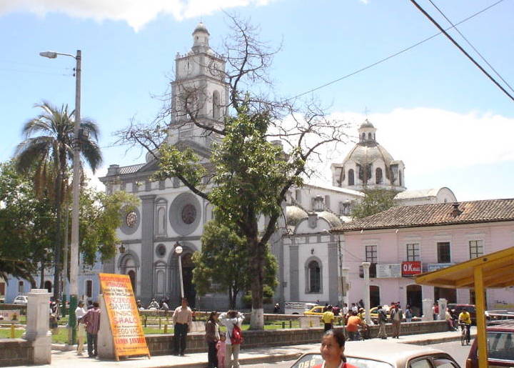
The city of Cayambe and its bizcochos
The town at the foot of the volcano, famous throughout Ecuador for its bizcochos with queso de hoja and dulce de leche.
At the foot of the volcano is the city of Cayambe, an obligatory food stop for anyone traveling the northern Sierra. Its greatest national fame rests on the bizcochos: dry, crunchy little breads, baked by hand, traditionally eaten with queso de hoja (a fresh cheese wrapped in leaves) and dulce de leche (manjar de leche). The Panamericana, where it passes through Cayambe, is lined with dozens of bizcocho shops where travelers pull over to buy and eat; it's a classic of any route through the area. Beyond the bizcochos, Cayambe is an important center for export roses (thanks to its equatorial light and its altitude, the area produces some of the best roses in the world) and dairy products. The city has the calm feel of an Andean town, with its church, its central park and its markets, and it's the base for exploring the volcano and the national park. Cayambe is also known for the Inti Raymi festival (the festival of the sun), one of the most important Indigenous celebrations in the northern Sierra, which fills the streets with music, dances, traditional dress and rituals tied to the solstice and the harvest, in June. Experiencing that festival, if it coincides with your trip, is an intense cultural experience. Getting there: the city is on the Panamericana, a little over an hour from Quito. Best time: any time for the bizcochos; June for Inti Raymi. Entry: free (the city). Tips: stopping to try bizcochos with queso de hoja and dulce de leche is an unmissable experience; buy roses if you're tempted.
ℹ️ Distance: The city of Cayambe, on the Panamericana, a little over 1 h from Quito · Best time to go: Any time; June for Inti Raymi · Entry: Free (the city) · Duration: 1 to 2 hours
4
Cayambe-Coca National Park
The enormous protected area running from snow-capped páramo to Amazonian forest, with lakes, wildlife and hot springs.
Cayambe volcano is only one part of the enormous Cayambe-Coca National Park, one of the largest and most diverse protected areas in Ecuador. The park stretches from the snowfields and high páramo of the Sierra, around Cayambe, down to the humid tropical forest of the Amazonian slope, taking in an astonishing variety of ecosystems and enormous biodiversity. It is also a key water source for the region. In its Andean sector, the park protects páramo, high-altitude lakes, and wildlife such as the condor, the spectacled bear, deer, the páramo wolf and high-altitude birds. There are sectors with beautiful lakes and walking trails. On its descent toward the east, the park includes areas of cloud forest and jungle, with waterfalls and very different wildlife. One of the best-known attractions in the lower part of the park is the Termas de Papallacta, famous hot springs in a mountain setting, hugely popular for unwinding (already on the slope toward the Amazon, on the Quito-Baeza road). Traveling Cayambe-Coca therefore lets you experience the contrast between the glacial cold of the heights and the humid heat of the lowlands, all within a single protected area. It's a perfect example of Ecuador's incredible diversity of ecological zones. Getting there: different access points depending on the sector (Cayambe for the volcano; Papallacta for the hot springs, on the road east). Best time: dry season for the páramo; the hot springs, year-round. Entry: park entry depending on the sector (ask locally). Tips: plan around which sector you want to see, because the distances are large.
ℹ️ Distance: A large park between the northern Sierra and the Amazon; several access points · Best time to go: Dry season for the páramo; hot springs year-round · Entry: Entry to Cayambe-Coca National Park is free in all its sectors. The Termas de Papallacta (Amazonian sector, on the way) do charge: baths from US$ 8–10; hotel spa from US$ 22–25 (2025) · Duration: Half a day to several days depending on the sector
5
The equator line on the volcano and the glacier landscape
The point where the equator crosses the snow peak, the permanent snow closest to the equator in the world.
One of the peculiarities that make Cayambe unique is that the equator (latitude 0°) crosses its high flanks, which makes it the only point on the planet covered in permanent ice and snow that sits on the equator. Somewhere on the mountain, at great altitude, glacial cold and latitude zero coincide, a geographical oddity found on no other snow peak in the world. This fact opens up a beautiful reflection on Ecuadorian geography: while at the nearby Mitad del Mundo the equator passes through a dry, sunny landscape, here, thanks to the sheer height of the volcano, that same parallel crosses a world of ice and snow. It's a perfect demonstration of how, in Ecuador, altitude rules over latitude when it comes to climate: on the equator it can be stifling on the coast, páramo-cold in the Sierra and perpetually icy on the summits. For the visitor, more than an exact marked point, what matters is the awareness and the landscape: standing before an equatorial glacier, seeing snow and ice in the middle of the tropics, and understanding why Ecuador is the 'country at the center of the world' on its summits too. The Cayambe landscape, with its glacier, its sand flats and its páramo, has an austere, imposing beauty. Getting there: the high sector is reached by climbing toward the refuge and the glacier (with an operator/suitable vehicle). Best time: clear days in the dry season, in the morning. Entry: included in park entry. Tips: the 'ice on the equator' fact is perfect for appreciating how singular the place is; combine it with the Mitad del Mundo.
ℹ️ Distance: The volcano's high flanks, toward the glacier (with an operator/suitable vehicle) · Best time to go: Clear days in the dry season, in the morning · Entry: Included in the free entry to Cayambe-Coca National Park · Duration: Part of the climb to the refuge/glacier
6
Cayambe from the northern Sierra (Otavalo, Cuicocha, Mitad del Mundo)
Cayambe as the axis of a route through the northern Sierra, combinable with Otavalo, Cuicocha lake and the Mitad del Mundo.
Beyond going up to the refuge, Cayambe is enjoyed as the backdrop to the whole northern Sierra and combines perfectly with the area's great attractions. A few kilometers away is Otavalo, with its famous Indigenous market of crafts and textiles —one of the best known in South America—, ideal for a morning of shopping and culture. Nearby are also the spectacular crater lake of Cuicocha and the city of Cotacachi, the leather capital. On the way between Quito and Cayambe, many travelers stop at the Mitad del Mundo, the monument and complex on the equator, a classic visit that connects symbolically with Cayambe's own record (the only snow peak in the world on the equator). The volcano thus becomes the centerpiece of a circuit joining mountains, markets, lakes and latitude zero. This combination lets you put together a 2-3 day getaway through the northern Sierra out of Quito, adding nature, Kichwa culture and craft shopping, with the snow-covered silhouette of Cayambe always there on the horizon.
ℹ️ Distance: Otavalo ~30-45 min from Cayambe; Mitad del Mundo on the route from Quito · Best time to go: Any time; Saturday for Otavalo's big market · Entry: Otavalo market free; Mitad del Mundo ~US$ 5 (complex) / from US$ 2 (monument); boat ride on Cuicocha US$ 3-5 (2025) · Duration: 1 to 3 days as a northern Sierra circuit
Advertisements
What nobody tells you

💵 Prices

Tickets

TypePrice
Cayambe-Coca National Park (entry)Free (open access; Ecuador's mainland protected areas charge no entry fee, MAATE policy 2025)
ASEGUIM certified mountain guide for the summit (compulsory above 5,000 m)Included in the summit tour; on its own, from ~US$ 150–250 per guide day (2025; verify)
Overnight at the Refugio Ruales-Oleas-Berge (4,600 m)US$ 10 daytime access (use of toilet and 24 h electricity); ~US$ 32 per person/day with dinner and breakfast; capacity 32 people, bring a sleeping bag (source: Cayambe Turismo GAD, verified July 2026)
4x4 / pickup transport up to the refugeUS$ 40–80 per trip from Cayambe depending on the vehicle (indicative 2025)
Termas de Papallacta (Amazonian sector of the park, on the way)Public baths from US$ 8–10; hotel-resort spa from US$ 22–25 (2025; verify when you visit)
🔄 updated monthlyOfficial / reference values · double-check when buying

Activities and tours

ActivityPriceDurationOperator
Day tour to the refuge and the flanks of CayambeUS$ 60–110 per person from Quito depending on the group (indicative 2025; transport and guide)Half a day to a full dayAgencies in Quito and Cayambe
Guided climb to the summit of Cayambe (2 days)US$ 299 per person (group of 3+) to US$ 480 (private, 1 person); includes ASEGUIM guide, transport from Quito, refuge, meals and technical equipment (verified July 2026)2 days (plus prior acclimatization)ASEGUIM certified mountaineering operators
Bizcocho food trail in CayambeBizcochos with queso de hoja and dulce de leche from US$ 2–6 per portion/bag (2025)1 to 2 hTraditional Cayambe shops along the Panamericana
Visit to the Termas de Papallacta (Cayambe-Coca)Entry from US$ 8–10 (baths) to US$ 22–25 (hotel spa); 2025Half a day to a full dayThe thermal complex and operators
Inti Raymi in Cayambe (festival of the sun, June)A free public celebration; specific events may chargeSeveral days (in June)Communities and the municipality
🔄 updated monthlyOfficial / reference values · double-check when buying
Advertisements

🚌 How to get there and distances

Getting around

ModePriceDurationNotes
Tour with transport from Quito or CayambeUS$ 60–110 per person (day trip to the refuge; depending on the group)Half a day to a full dayThe most comfortable option, above all because of the altitude and the final dirt road up to the refuge, which requires a suitable vehicle
Hired 4x4 / pickup to the refugeUS$ 40–80 per trip from Cayambe (indicative 2025)Approx. 1 to 1.5 h from CayambeThe final climb to the refuge is on dirt and can be in poor condition; a suitable vehicle or operator transport is advisable
Bus Quito → Cayambe (Coop. Flor del Valle)US$ 2.50–3 per person; paid IN CASH on boarding or at the ticket office1 h 30 min approx.Cooperativa Flor del Valle leaves from the La Ofelia terminal (north Quito) every 10-15 min, from 5:00 to 21:00. There are also departures from Carcelén. No cards or QR: cash, with small bills. From the city of Cayambe you have to arrange transport to the volcano separately (source: Cooperativa Flor del Valle, verified July 2026)
Taxi in Cayambe (the city)US$ 1.50–4 for a ride within the city (cash)VariableUseful for getting around the city and for arranging transfers; for the refuge you need a suitable 4x4/pickup. There's no Uber or Cabify: you flag them down in the street or the hotel calls one. Agree the fare beforehand
Real-time app and payment methodFree (apps)N/AThere is no app tracking the area's buses live. Google Maps helps locate the La Ofelia terminal and estimate the route to Cayambe; Moovit has good coverage of Quito's urban and interparish buses (useful for reaching the terminal), but it doesn't track Flor del Valle to Cayambe live. There is no public transport to the volcano: you book a tour or a 4x4. All local transport is paid in cash (source: Moovit Ecuador and Cooperativa Flor del Valle, verified July 2026)
🔄 updated monthlyOfficial / reference values · double-check when buying

How to get there

RouteAirlines / operatorsAvg. priceDuration
Quito → Cayambe (the city) by busCoop. Flor del Valle (from the La Ofelia terminal; also Carcelén)US$ 2.50–3 per person (cash)1 h 30 min approx.
Quito → Cayambe → the volcano refuge (tour or 4x4)Agencies and mountain operatorsUS$ 60–110 per person (day trip to the refuge)Half a day (combining legs)
Otavalo → Cayambe (bus)Intercity cooperativesUS$ 0.75–1.50 per personApprox. 30 to 45 min
Mariscal Sucre airport (UIO, Tababela) → CayambeTaxis/apps or a tourUS$ 30–45 by taxi (indicative 2025)Approx. 1 h
🔄 updated monthlyOfficial / reference values · double-check when buying

🏨 Where to stay

No exact prices: a scale from $ (budget) to $$$$$ (luxury), with 2-3 options per category.

CategoryPriceRecommended options
Budget guesthouses in Cayambe / Otavalo$$$$$US$ 12–30 per person; budget guesthouses and hotels in Cayambe and nearby Otavalo, good as a base for exploring the northern Sierra
Mid-range hotels and hosterías in Cayambe$$$$$US$ 35-70 a night. In the Ministry of Tourism's national registry, the canton of Cayambe has 130 registered establishments. The highest-category ones in town are the Plaza Hotel María Isolina (3-star hotel, 24 de Mayo y Av. Víctor Cartagena, tel. 099 956 5419) and, in the rural parish of Cangahua, El Torreal (3-star hotel, tel. 099 417 8343). In the center there are also a dozen 1-star guesthouses —Hostal Cayambe (Bolívar y Juan Montalvo), Hostal El Sol (Av. Rocafuerte y 29 de Septiembre), Hostal Miraflores (Av. Natalia Jarrín)— which are handled by phone and DO NOT PUBLISH A RATE. Ecuador has a downloadable national tourism registry, published by the Ministry of Tourism and updated in August 2026: 35,571 establishments with trade name, activity, classification, category (stars or forks), province, canton, parish, address, phone and email. It downloads as an Excel file from https://servicios.turismo.gob.ec/catastro-turistico/ (consulted on 08/08/2026). It's the way to confirm that a lodging is registered and in what category.
Historic haciendas of the northern Sierra$$$$$US$ 90-220 a night. The area preserves several colonial haciendas converted into hosterías, all registered in the national registry: Hacienda Guachalá (3-star hostería, Panamericana Norte on the road to Cangahua, Cangahua parish, tel. 096 911 0019), Molino San Juan Hacienda (3 stars, Panamericana Norte, San José de Ayora), Hacienda María Delfina (3 stars, on the road to Pambamarca, Otón) and Maimara (3 stars, Olmedo). ⚠️ WARNING ABOUT THE GUACHALÁ WEBSITE: the domain guachala.com published by the registry itself now appears BLOCKED as a suspicious site by network security filters (checked on 08/08/2026); do not open it, arrange the booking by phone. Ecuador has a downloadable national tourism registry, published by the Ministry of Tourism and updated in August 2026: 35,571 establishments with trade name, activity, classification, category (stars or forks), province, canton, parish, address, phone and email. It downloads as an Excel file from https://servicios.turismo.gob.ec/catastro-turistico/ (consulted on 08/08/2026). It's the way to confirm that a lodging is registered and in what category.
Mountain refuge (high-altitude overnight)$$$$$Refugio Ruales-Oleas-Berge (4,600 m): ~US$ 32 per person/day with dinner and breakfast, or US$ 10 daytime access. Basic overnight for mountaineers; very cold, bring a sleeping bag

🍴 Where to eat

Cayambe bizcocho shops
The obligatory stop in Cayambe. The national registry lists the bizcocho shops as cafés, with name and address: Paradero del Bizcocho (two-cup category, the highest in the canton, Víctor Cartagena, tel. 098 452 4446), Bizcochos San Pedro (Olmedo y Bolívar), Bizcochos Francisco (Víctor Cartagena y 24 de Mayo), Horno de Bizcochos Katherine (Av. Natalia Jarrín y Sucre), Cafetería Rey del Bizcocho (Av. Natalia Jarrín y Sucre) and Gran Bizcocho (Víctor Cartagena y 24 de Mayo). THEY DO NOT PUBLISH A MENU: they are counter shops, you pay per bag of bizcochos and ball of queso de hoja. Ecuador has a downloadable national tourism registry, published by the Ministry of Tourism and updated in August 2026: 35,571 establishments with trade name, activity, classification, category (stars or forks), province, canton, parish, address, phone and email. It downloads as an Excel file from https://servicios.turismo.gob.ec/catastro-turistico/ (consulted on 08/08/2026). It's the way to confirm that a lodging is registered and in what category.
Restaurants in the city of Cayambe
Typical highland dishes such as hornado, fritada, broths and local dairy, well regarded across the region
The refuge café
The refuge usually has hot drinks and snacks; restorative against the extreme cold at altitude
Cayambe dairy and cheeses
Cayambe is cattle and dairy country; its cheeses, yogurts and dulce de leche are highly regarded in Ecuador
Mid-range and hostería restaurants
The highest-rated restaurant in the canton in the national registry is the one at Hacienda La Compañía de Jesús (three forks), on the Panamericana Norte km 5.5, San José de Ayora parish: it's the flower hacienda visited for its rose gardens. CAREFUL: the domain haciendalacompania.com that appears in its contact email NO LONGER RESOLVES (checked on 08/08/2026); you have to call 099 950 6691. In town, the two-fork places are La Super Parrillada (Panamericana Norte y Mariana de Jesús) and El Bucanero (a seafood place, Alianza y Restauración). Ecuador has a downloadable national tourism registry, published by the Ministry of Tourism and updated in August 2026: 35,571 establishments with trade name, activity, classification, category (stars or forks), province, canton, parish, address, phone and email. It downloads as an Excel file from https://servicios.turismo.gob.ec/catastro-turistico/ (consulted on 08/08/2026). It's the way to confirm that a lodging is registered and in what category.
Advertisements

📖 History of Cayambe Volcano

Origins, formation and what the sources say.

The Kayambi people and the sacred mountain

Picture eternal snow and blue ice right on the line of the equator: Cayambe is the only glaciated point on the planet crossed by latitude zero, and so it holds on its summit the frozen place closest to the equator anywhere in the world. But long before that geographical record caught the attention of scientists and mountaineers, this mountain already had owners in spirit: the Kayambi people (or cayambi), one of the oldest Indigenous nations of Ecuador's northern Sierra, who have lived on this land since long before the Incas arrived and who gave it its name. For the Kayambis, the snow peak is a sacred mountain, a guardian presence tied to water, to the fertility of the land and to their identity as a people. The name 'Cayambe' designates at once the volcano, the city and the people who live at its feet, in a deep union between the people and the mountain.

The Kayambis developed a farming and herding society adapted to the páramo and the fertile high valleys, with their own organization, their language (today Kichwa) and their traditions. Their culture is still very much alive: the communities in the area preserve dress, music, dances, forms of communal work (the minga) and ancestral celebrations, especially those tied to the sun and the harvests. The region is one of the hearts of Indigenous culture in Ecuador's northern Sierra.

The sacred relationship with Cayambe continues to this day, and the volcano is a central part of its people's symbolic universe. This cultural dimension is key to understanding that Cayambe is not just a geographical record or a mountaineering objective, but a mountain with centuries of human, spiritual and communal history at its feet.

Cayambe: a people, a volcano and a city
The place name 'Cayambe' is associated with the Kayambi people, the area's ancestral inhabitants, and applies equally to the volcano, the canton and the city. The spelling varies between 'Cayambe' and 'Kayambi' depending on whether it refers to the place or to the people, reflecting the union between the community and its territory.
Source: https://es.wikipedia.org/wiki/Cayambe_(cant%C3%B3n)

The resistance to the Incas and the battle of Yahuarcocha

At the end of the 15th century, as the Inca Empire pushed north under the Inca Huayna Cápac, the peoples of Ecuador's northern Sierra —among them the Kayambis, alongside the Caranquis and others— put up fierce resistance. Unlike regions that fell relatively quickly, the north was one of the hardest fronts for Inca expansion, and the conquest of these territories cost years of war.

The most remembered episode of that resistance is the battle associated with the lake of Yahuarcocha, in the neighboring province of Imbabura. According to tradition and the chronicles, after a long and bloody campaign, the Incas finally managed to subdue the rebel peoples of the north in a confrontation whose outcome is said to have been so brutal that the lake was stained with blood, which is where its name would come from: 'Yahuarcocha' means 'lake of blood' in Kichwa. Although the figures and the details of that episode belong to the realm of tradition and should be treated with caution, they symbolize how hard these peoples' resistance was.

The incorporation of the northern Sierra into the Inca Empire was therefore late and conflictive, and it happened shortly before the Spanish arrived, who found a region only recently and precariously integrated into the Tahuantinsuyo. That history of resistance is part of the identity and pride of the peoples of the Cayambe area, and it shows in their culture and their memory.

Yahuarcocha, the 'lake of blood'
Tradition links the name of the lake of Yahuarcocha ('lake of blood') to a bloody battle in which the Incas are said to have crushed the resistance of the northern peoples (Caranquis, Cayambis and others) at the end of the 15th century. The casualty figures mentioned in some chronicles are considered exaggerated or legendary by historians, but the episode reflects how hard the conquest of the north really was.
Source: https://es.wikipedia.org/wiki/Yahuarcocha

The singular volcano: snow and ice on the equator

Geographically, Cayambe holds one of the most curious distinctions on the planet: it is the only point covered in permanent snow and ice crossed by the equator. Latitude 0° runs across its high flanks, so that somewhere on the mountain, at great altitude, glacier and equator coincide. There is no other snow peak in the world on that imaginary line, which makes Cayambe the permanently frozen place closest to the equator on the planet.

This rarity illustrates perfectly a fundamental principle of Ecuadorian geography: in the tropics, and especially on the equator, it is altitude —rather than latitude— that determines climate. That is why, on the same equatorial line, Ecuador has everything from the humid heat of the coast and the jungle to the cold of the páramo and the perpetual ice of summits like Cayambe. The mountain is living testimony to that logic of 'climatic tiers' that so fascinated naturalists like Humboldt.

Cayambe is an active stratovolcano, capped by a glacier, and forms part of the Cordillera Real of the Ecuadorian Andes. Although it has had no major eruptions in recent historical times, it is considered an active volcano under watch. Its glacier, like those of the other Ecuadorian snow peaks, has retreated significantly because of climate change, a phenomenon that causes concern for its impact on water and on the region's ecosystems.

The only permanent ice on the equator
Cayambe is cited as the only point of permanent snow/ice in the world crossed by the equator, and the frozen place closest to the equator on the planet. This distinction comes from its great altitude combined with its position almost exactly on latitude 0°.
Source: https://en.wikipedia.org/wiki/Cayambe_(volcano)

Whymper, the Carrels and mountaineering on Cayambe (1880)

Like many of Ecuador's great Andean volcanoes, Cayambe entered the history of mountaineering through the celebrated English climber Edward Whymper, famous for the first ascent of the Matterhorn in the Alps. During his expedition to the Ecuadorian Andes in 1880, Whymper, accompanied by the experienced Italian guides Jean-Antoine and Louis Carrel, made the first documented ascent of Cayambe's summit, on the same trip on which they crowned Chimborazo and other snow peaks.

Whymper's expedition had a double purpose: sporting and scientific. Besides conquering summits, the mountaineer made observations on the effects of altitude on the human body and on the geography and geology of the Ecuadorian volcanoes. His ascents and the book he wrote about his travels through the Andes of Ecuador spread word of the country's mountaineering riches internationally and opened the way to modern climbing in the region.

Since then, Cayambe has consolidated as one of the great objectives of Ecuadorian high-mountain climbing, with the particularity of a reputation as a technically demanding volcano because of the crevasses in its glacier. Today it is climbed by mountaineers from all over the world, always with the seriousness a glaciated mountain of almost 5,800 meters demands. The refuges and the mountain infrastructure recall those pioneers and keep alive the climbing tradition begun in the 19th century.

First documented ascent (1880)
The history of mountaineering attributes the first documented ascent of Cayambe to Edward Whymper and the guides Jean-Antoine and Louis Carrel in 1880, as part of his celebrated expedition through the Ecuadorian volcanoes. As on other mountains, an earlier presence of local inhabitants in the high areas cannot be ruled out, but the recorded summit corresponds to this expedition.
Source: https://en.wikipedia.org/wiki/Edward_Whymper

Cayambe-Coca National Park: from snow to jungle

Cayambe volcano is the Andean heart of one of Ecuador's largest and most biodiverse protected areas: Cayambe-Coca National Park. Created to protect this vast territory, the park has an astonishing feature: it stretches from the glaciers and páramo of the high cordillera, around Cayambe, down the eastern slope to the humid tropical forest of the Amazon, taking in an enormous variety of ecological tiers and ecosystems.

That diversity makes it a key refuge of biodiversity and a fundamental source of water for wide regions of the country. In its Andean sector it protects páramo, high-altitude lakes and species such as the condor, the spectacled bear and the páramo wolf; on its descent to the east, cloud forest and jungle with completely different fauna and flora. One of its most famous attractions is the Termas de Papallacta, in the transition zone toward the Amazon, well-known hot springs in a mountain setting.

The park is a perfect example of Ecuador's extraordinary geographical diversity, where within a few kilometers you go from eternal ice to the heat of the jungle. Protecting this area is essential not only for its natural richness but for its role in the water cycle and in regional climate regulation. Cayambe, with its glacier threatened by climate change, is at once the jewel and the sentinel of this great park that joins snow and jungle.

A park from páramo to jungle
Cayambe-Coca National Park stands out for its altitudinal gradient, running from Andean snow peaks and páramo to Amazonian tropical forest, which gives it exceptional biodiversity and a key role in the water cycle. It is one of the most frequently cited examples of Ecuador's diversity of ecosystems within a single protected area.
Source: https://es.wikipedia.org/wiki/Parque_nacional_Cayambe-Coca

Cayambe today: bizcochos, roses and Inti Raymi

At the foot of the volcano, the city of Cayambe is today a prosperous center of the northern Sierra, known throughout Ecuador for several marks of identity. The tastiest are its bizcochos: dry, crunchy little breads, baked by hand, eaten with queso de hoja and dulce de leche, sold in dozens of shops along the Panamericana. Stopping to buy bizcochos in Cayambe is almost a ritual for anyone traveling through the area.

Cayambe is also a major hub of the flower industry: thanks to the equatorial light, the altitude and the climate, the region produces some of the best roses in the world, exported across the planet. To that is added significant dairy production. This combination of farming, herding and flower growing sustains much of the local economy and coexists with the mountain and nature tourism tied to the volcano and the national park.

But perhaps what best expresses the soul of Cayambe is Inti Raymi, the festival of the sun, one of the most important Indigenous celebrations in the northern Sierra. Every year, around the June solstice, the Kayambi communities fill the streets with music, circle dances, traditional dress and rituals celebrating the sun and the harvest, in an intense and deeply rooted cultural expression. Inti Raymi links Cayambe's present with its ancestral past, a reminder that, under the gaze of the sacred volcano, the culture of the Kayambi people is still fully alive.

Inti Raymi in Cayambe
Inti Raymi (the festival of the sun) is an Andean celebration tied to the June solstice and to the harvests, very important among the Kayambi communities of the area. It combines pre-Hispanic roots with later elements; its specific forms and dates vary between communities, within a tradition shared across the whole northern Sierra.
Source: https://es.wikipedia.org/wiki/Inti_Raymi

📚 Bibliography

  • Wikipedia (ES) — «Cayambe (volcán)»: https://es.wikipedia.org/wiki/Cayambe_(volc%C3%A1n)
  • Wikipedia (EN) — «Cayambe (volcano)»: https://en.wikipedia.org/wiki/Cayambe_(volcano)
  • Wikipedia (ES) — «Cayambe (cantón)»: https://es.wikipedia.org/wiki/Cayambe_(cant%C3%B3n)
  • Wikipedia (ES) — «Parque nacional Cayambe-Coca»: https://es.wikipedia.org/wiki/Parque_nacional_Cayambe-Coca
  • Wikipedia (ES) — «Yahuarcocha»: https://es.wikipedia.org/wiki/Yahuarcocha
  • Wikipedia (EN) — «Edward Whymper»: https://en.wikipedia.org/wiki/Edward_Whymper
  • Wikipedia (ES) — «Inti Raymi»: https://es.wikipedia.org/wiki/Inti_Raymi
  • Ministerio del Ambiente del Ecuador (MAATE): https://www.ambiente.gob.ec/

❓ Frequently asked questions

What makes Cayambe so special?+
It's Ecuador's third-highest volcano (5,790 m) and, above all, the only point in the world covered in permanent snow and ice that is crossed by the equator. On its high flanks, on latitude zero, lies the frozen place closest to the equator on the planet. It's a unique geographical oddity, as well as an imposing snow peak in the northern Sierra.
Do you have to be a mountaineer to visit it?+
No. Plenty of people go up only as far as the Refugio Oleas-Berge (at around 4,600 m) to see the volcano, the glacier and the páramo, and walk a little higher, without doing any high-mountain climbing. Summiting, on the other hand, is a technical ascent over a crevassed glacier, considered one of the most demanding in Ecuador, only for mountaineers with experience, equipment, acclimatization and a compulsory certified guide.
How do I get to the Cayambe refuge?+
The easiest way is a tour or a hired 4x4/pickup, because the final road up to the refuge is dirt and is usually in poor condition, requiring a suitable vehicle. By bus you can reach the city of Cayambe (a little over an hour from Quito), but from there you have to arrange transport to the volcano separately.
What are Cayambe's bizcochos?+
They are the area's most famous food specialty: dry, crunchy little breads, baked by hand, eaten with queso de hoja (fresh cheese) and dulce de leche (manjar). Along the Panamericana, where it passes through Cayambe, there are dozens of shops where travelers stop to buy and try them. It's a classic stop.
How do I protect myself from the cold and the altitude?+
Acclimatize for a few days at altitude beforehand (Quito helps), go up slowly, drink plenty of water and watch for symptoms of altitude sickness (headache, dizziness, nausea). Bring plenty of mountain clothing, strong sun protection, sunglasses and water. The weather changes fast: it can go from sun to mist and wind in minutes, so come prepared.
When is the best time to go?+
The dry season, above all from June to September and December-January, offers the clearest skies and the best conditions for seeing the summit and for mountaineering. In the rainy season it's usually hidden by cloud. It's best to go in the morning, which is when it tends to be clearest. If your trip falls in June, you can also catch Inti Raymi.
What other places can I combine the visit with?+
Cayambe combines very well with a route through the northern Sierra: Otavalo and its market, Cuicocha lake, Ibarra and the nearby Mitad del Mundo. Quito or the city of Cayambe itself are the usual bases. It's an ideal destination to add to a trip through the northern Andes of the country.
How do I get to Cayambe from Quito, and how do you pay for the bus?+
On a Cooperativa Flor del Valle bus, which leaves from the La Ofelia terminal (north Quito) every 10-15 minutes, from 5:00 to 21:00, and also from Carcelén. The ticket costs around US$ 2.50–3 and the trip takes about an hour and a half. You pay in cash, with small bills: there's no card or QR. There is no app tracking the bus live; Moovit helps you get around Quito as far as the terminal, but there's no public transport to the volcano, so from the city of Cayambe you have to book a tour or a 4x4.
Sources consulted (17)
Still planning?
Explore more destinations in Ecuador
See all destinations →
Advertisements
Image credits
Photos from Wikimedia Commons, each under its own licence (CC BY, CC BY-SA or public domain). Open each file to see its author and licence.
Cayambe