Viajá con Gus
HomeEcuadorCotopaxi National Park
Cotopaxi National Park
🇪🇨 Ecuador · Sierra (Andean Highlands)

Cotopaxi National Park

Jump to what you need
📌Province
Cotopaxi National Park spreads across the provinces of Cotopaxi, Pichincha and Napo, in the heart of Ecuador's central Sierra, within the Avenida de los Volcanes. Its core is the Cotopaxi volcano, a snowcapped cone of about 5,897 meters that is one of the highest active volcanoes in the world and, for many, the most beautiful in the Ecuadorian Andes. The park protects a vast high Andean páramo, glacial lagoons and pine woods, and it is one of the most visited and best-loved protected areas in the country. The city of Latacunga, capital of Cotopaxi province, works as a service base, although the park is also easy to visit on a day trip from Quito.
📌Service city
Latacunga, about 90 km south of Quito on the Panamericana (E35), is the natural base for exploring the park: it has hotels, country lodges in the surrounding area, restaurants, ATMs, a bus terminal and agencies that organize excursions, climbs and bike outings. A great many travelers, however, visit Cotopaxi on a day trip from Quito (just over an hour from the northern entrance checkpoint). The park has two main entrances: the Caspi/northern checkpoint (the most used, near Machachi) and the southern entrance (via Ticatilín, toward Latacunga). In the surrounding area there are very characteristic high-altitude lodges that serve as a base camp for the páramo.
📌Best time to go
Cotopaxi can be visited all year, but choose according to the ever-changing high-altitude weather. The driest months with the clearest skies —ideal for seeing the snowcapped cone without cloud— usually run from June to September and, to a lesser extent, December and January; those are also the best months for mountaineering and the summit climb. The rainiest season runs roughly from February to May and from October to November, with more fog and the chance of snow. Whatever the month, it's cold on the páramo, the sun is fierce and the weather can change in minutes: always come prepared for four seasons in one day.
📌Suggested days
One full day is enough for the essentials: the interpretation center, the Limpiopungo lagoon, a drive across the páramo with wildlife spotting and the vehicle climb to the volcano's parking area, from where you walk up to the José Rivas refuge (~4,864 m). With two days you can add longer walks, mountain biking on the park's tracks and enjoy a high-altitude lodge at leisure to acclimatize. For anyone dreaming of the summit (5,897 m), the technical ascent with a high-mountain guide requires an extra day and night (rest in the refuge and a pre-dawn start), plus good prior acclimatization.
💱 USD exchange rate
Loading rate…
🌤️ Weather in Cotopaxi National Park
Loading weather…

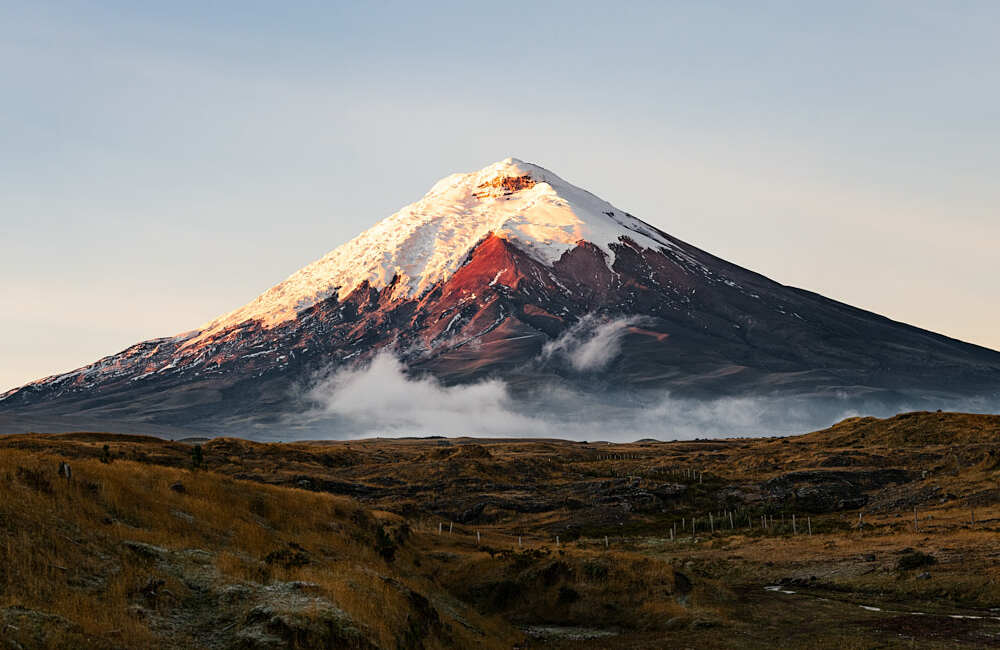
Few landscapes sum up the grandeur of the Ecuadorian Andes as well as Cotopaxi National Park. At the center of the so-called 'Avenida de los Volcanes', the perfect snowcapped cone of Cotopaxi —about 5,897 meters, one of the highest active volcanoes on the planet— rises above an immense golden páramo, dotted with glacial lagoons, herds of wild horses and the slow flight of condors. It's one of those places where nature feels enormous and you feel small and grateful.

The park, created in 1975, protects far more than the volcano: it is an extremely rich high-altitude ecosystem, with white-tailed deer, páramo wolves (Andean foxes), rabbits, condors and, around the Limpiopungo lagoon, surprising birdlife. Walking its trails, climbing to the José Rivas refuge at the edge of the glacier, pedaling downhill on its dirt tracks or simply looking at the snowcapped cone reflected in a lagoon are experiences that stay with you forever.

This guide covers Cotopaxi with a practical eye: how to get there from Quito or Latacunga, what to see inside the park, how to climb to the refuge, what a summit attempt takes, where to sleep and eat, and how to look after yourself at altitude and in the páramo's changeable weather. Admission to the park is free —it's a protected area of the Ecuadorian state— so with a little planning, warm clothing and respect for the mountain, Cotopaxi delivers one of the most memorable days of any trip through Ecuador.

📖 History of Cotopaxi National Park

Cotopaxi was a sacred mountain long before it had a name on European maps. Pre-Inca Andean peoples and, later, the Incas venerated it as a deity: its name, with Quichua roots, is usually interpreted as 'neck' or 'mass of the Moon' or 'soft throne', and myths about the fire of the earth grew up around it. Through history, the volcano periodically reminded everyone of its power with devastating eruptions: those of 1742, 1768 and, above all, that of 1877, whose lahars (avalanches of mud and melted ice) wiped out entire valleys and traveled dozens of kilometers, reaching the coast and the Amazon. European science bowed to its beauty: the naturalist Alexander von Humboldt tried to study and describe it at the start of the 19th century (around 1802), and in 1872 the German Wilhelm Reiss, together with the Colombian Ángel Escobar, made the first documented ascent to the summit. Recognition of its natural value culminated in 1975, when the Ecuadorian state created Cotopaxi National Park to protect the volcano, its glacier and the surrounding páramo. Since then it has been one of the country's symbols and one of its most visited protected areas. The full story is on our history page.

Read the full history ↓

🗺️ What to see

1
The Cotopaxi volcano and its snowcapped cone
The absolute star: one of the highest active volcanoes in the world, its almost perfect snowcapped cone dominating the páramo.
The Cotopaxi volcano is the heart and the reason for the park. At about 5,897 meters, it is one of the highest active volcanoes on the planet and, thanks to the almost perfect symmetry of its cone crowned with snow and glacier, one of the most photographed in the Andes. Seeing it clear of cloud, cut out against the páramo sky, is one of those images that justify the trip on their own. It is an active volcano and closely watched: through its history it has had major eruptions, and episodes of activity (such as in 2015) led to temporary closure of access to the cone. So before planning the climb, confirm the state of the volcano and access conditions with the park administration, as they can change. Most visitors enjoy it from the páramo and from the vehicle climb up to the high parking area (around 4,500 m), the starting point for the walk to the refuge. Anyone going for the summit must always do so with a certified high-mountain guide and proper acclimatization. Best time to see it clear: early in the morning and in the driest months (June to September, December–January), since clouds tend to cover it as the day goes on. Tip: bring warm layers, strong sun protection and go early to 'catch' the cone without cloud.
ℹ️ Distance: Center of the park; vehicle climb to the high parking area (~4,500 m) · Best time: Early morning and dry months (June-September, December–January); clouds cover it in the afternoon · Entry: Free (open access; admission to Cotopaxi National Park is free because it is a state protected area) · Duration: Variable: half a day from the páramo; 2 days for a summit attempt
2
José Rivas refuge (~4,864 m)
The mountain refuge at the edge of the glacier, goal of the classic walk and base camp for summit climbs.
The José Rivas refuge (José Ribas) stands on the volcano's flank, at around 4,864 meters, and is one of the great objectives of any visit to Cotopaxi. It works as a rest point for hikers walking up and as a base camp for mountaineers attempting the summit, setting out before dawn. The classic experience is to drive up to the high parking area (around 4,500 m) and from there walk between 30 and 60 minutes uphill, on a volcanic sand trail with a demanding gradient, to the refuge. It is not a technical walk, but the altitude makes it hard: go slowly, breathe deeply and enjoy every pause with the view of the páramo far below. The refuge usually has a space to rest, warm up and get something hot to drink. Those who are well acclimatized can continue a little higher, up to the edge of the glacier, always with caution. Best time: early morning and clear days. Tips: go up very slowly to avoid soroche (altitude sickness), bring water, warm layers, a hat, gloves and sun protection, and don't go up if you haven't acclimatized beforehand (ideally sleeping at a good altitude the night before).
ℹ️ Distance: 30 to 60 min walking uphill from the high parking area (~4,500 m) · Best time: Early morning and clear days; avoid without prior acclimatization · Entry: Free (open access inside the park); food and drink at the refuge are extra (hot chocolate ~US$ 2,50, locro ~US$ 6). Overnight at the refuge: US$ 33,60 per person with dinner, midnight coffee and breakfast (source: Refugio José Ribas, verified July 2026) · Duration: 2 to 3 hours (round trip from the parking area)
3
Limpiopungo lagoon (~3,800 m)
The páramo lagoon at the foot of Cotopaxi, ringed by a flat trail ideal for walking and birdwatching.
The Limpiopungo lagoon is one of the most serene and beautiful corners of the park: a sheet of water at about 3,800 meters, laid out in the middle of the páramo, with the Cotopaxi cone behind it (when the sky allows) and Cerro Rumiñahui standing guard on the other side. It's the easiest and most accessible postcard shot in the park, perfect for anyone who doesn't want to go so high. A flat trail several kilometers long skirts the lagoon and lets you walk it at ease, without great effort despite the altitude. It's one of the best places for birdwatching —ducks, Andean gulls, sandpipers and other wetland species— and for appreciating typical páramo vegetation, with its golden tussock grass and cushion plants. Around the lagoon it's also common to see horses grazing and, with luck, other páramo animals. It's an ideal spot to acclimatize with a gentle walk before going higher. Best time: morning, with good light and the volcano clearer. Tips: bring warm layers (a cold wind blows), sun protection and binoculars if you like birds; walk unhurried so you don't feel the altitude.
ℹ️ Distance: On the park's páramo, on the way to the volcano (vehicle access and a walking trail) · Best time: Morning for better light and a clearer volcano · Entry: Free (open access inside the park) · Duration: 1 to 2 hours (full loop of the lagoon)
4
The Andean páramo and its wildlife
Immense high-altitude grasslands where wild horses, deer and páramo wolves live and condors fly.
Beyond the volcano, Cotopaxi's great treasure is its páramo: a unique high-altitude ecosystem of golden tussock grass, cushion plants, small lagoons and an enormous silence barely broken by the wind. Crossing it —by vehicle, on foot or by bike— is entering a world of shifting light and endless horizons, with the snowcapped cone always as a backdrop. The park's páramo is home to surprising wildlife. It is famous for its semi-wild horses, which graze freely and are often seen; there are also white-tailed deer, rabbits, páramo wolves (the Andean fox) and, in the sky, the majestic Andean condor, along with caracaras and other birds of prey. Spotting a condor gliding over the volcano is an unforgettable experience. The vegetation, adapted to cold and altitude, includes the characteristic cushion plants, achupallas, tussock grass and the pine woods planted in some areas. It's a fragile landscape best explored along the marked trails and without leaving a trace. Best time: morning, for better light and more wildlife activity. Tips: move quietly, bring binoculars, dress in layers and keep your distance from the animals (especially the horses, which are wild).
ℹ️ Distance: The whole park; best covered by vehicle, on foot or by bike along the trails · Best time: Morning, with good light and more wildlife activity · Entry: Free (open access inside the park) · Duration: Half a day (can be combined with the lagoon and the refuge)
5
Interpretation center / Mariscal Sucre Museum
The park's visitor center, with information about the volcano, the páramo and its wildlife, ideal for starting the visit.
The park's interpretation center, linked to the name of Mariscal Antonio José de Sucre, is a good first stop on arrival: it helps you understand what you're about to see and make more of the visit. It explains the volcano's geological formation, its eruptive history, the páramo ecosystem and the wildlife and plants the park protects. It usually has displays, models, information panels and, sometimes, remains related to the volcano's activity, plus protected-area staff who can advise on trails, weather and conditions for the day. It is especially useful for families and for anyone visiting Cotopaxi for the first time. It is designed as a complement to the outing itself: a short visit before heading into the páramo, the lagoon and the climb to the refuge. Confirm hours and availability with the park administration, as they can change. Best time: at the start of the day, before touring the park. Tips: take the chance to ask about the state of the volcano, which trails are open and the safety recommendations for the day.
ℹ️ Distance: Inside the park, near the entrances (check the location on arrival) · Best time: At the start of the visit · Entry: Free (open access inside the park) · Duration: 30 to 45 minutes
6
Ascent to the Cotopaxi summit (5,897 m)
The great high-mountain challenge: the night climb up the glacier to the summit, only with a certified guide.
Reaching the summit of Cotopaxi (about 5,897 m) is one of the great dreams of mountaineering in Ecuador, but it is a serious high-mountain undertaking that should not be taken lightly. It requires very good fitness, prior acclimatization to altitude, technical gear (crampons, ice axe, harness, helmet) and, without exception, the company of a certified high-mountain guide. The classic ascent begins with a night's rest at the José Rivas refuge (~4,864 m). The summit push starts in the small hours (usually around midnight or one in the morning), to walk on snow that is still firm and reach the top at dawn, before the sun softens the glacier. It's several hours of climbing over ice and snow, roped up, on crevassed terrain that demands experience. The reward is enormous: the glacier summit and its crater, and a sunrise over the sea of páramo and the other Andean volcanoes. But the mountain decides: success depends on the weather, the state of the volcano (active and monitored) and each person's condition. You have to be willing to turn back if conditions don't cooperate. Best time: dry months (June to September, December–January). Tips: acclimatize for several days beforehand at altitude, hire a guide and gear from serious operators, and check the state of the volcano and the open routes before planning the climb.
ℹ️ Distance: From the José Rivas refuge (~4,864 m) to the summit (~5,897 m) · Best time: Dry months (June-September, December–January); night departure · Entry: The climb is mandatory with an ASEGUIM-certified high-mountain guide; 2-day summit tour US$ 350–700 per person depending on group and services (2025; includes guide, gear, refuge and transfers) · Duration: 2 days (night in the refuge + night climb)
7
Mountain biking in the park
Descents and rides on mountain bikes along the páramo's dirt tracks, one of the star activities.
Cotopaxi is one of the best places in Ecuador for mountain biking, and many excursions include it as the highlight of the day. The combination of dirt tracks, generous gradients and páramo landscapes with the volcano behind makes the bike descent fun and panoramic, and it works even for people who aren't expert cyclists. The most popular format is to go up by vehicle to a high point in the park (for example, near the volcano parking area or the lagoon) and come down pedaling —or letting gravity do the work— along the dirt roads, stopping to take photos and watch wildlife. There are also flatter loops around the lagoon for a gentle ride. Agencies in Latacunga and Quito usually provide the bike, helmet, protective gear and guide as part of the package. You don't need great technique, but you do need care with loose ground and the cold. Best time: dry, clear days, in the morning. Tips: always wear a helmet, bring warm layers and gloves (the wind on the descent is chilling), and check the bike and brakes before setting off.
ℹ️ Distance: The park's dirt tracks (descent from high points down to the páramo) · Best time: Dry, clear days, in the morning · Entry: Park admission free; bike, helmet and guide within the excursion package (US$ 45–70 per person; or added to the day trip) · Duration: 2 to 3 hours
8
Cerro Rumiñahui and páramo walks
The extinct volcano next door and its trails, a trekking option with great views of Cotopaxi.
Facing Cotopaxi, on the other side of the Limpiopungo lagoon, rises Rumiñahui (around 4,700 m), an old extinct volcano with a jagged summit and rocky appearance, very different from the snowcapped cone of its famous neighbor. Its slopes and trails offer some of the best walks in the park for those looking for more effort and spectacular views. The routes toward Rumiñahui start from the Limpiopungo area and cross the páramo, gaining height little by little. Reaching its summits is a mountain objective in itself, best tackled with a guide and good acclimatization, but even a stretch of the trail gives magnificent panoramas of Cotopaxi reflected in the lagoon. Besides Rumiñahui, the park has other páramo trails —of varying difficulty— ideal for walkers who want to feel the immensity of the Andean high plateau away from the crowds. These are routes of solitude, wind and open horizons. Best time: clear days, in the morning. Tips: for the summits, hire a guide; bring a GPS or map, warm layers and plenty of water, and tell someone your route. The páramo weather changes fast: be ready for fog and wind.
ℹ️ Distance: From the Limpiopungo lagoon area, on the park's páramo · Best time: Clear days, in the morning · Entry: Free (open access inside the park); a guide is recommended for the Rumiñahui summit (US$ 40–80 per group, indicative 2025) · Duration: Half a day to a full day (depending on the route)
9
High-altitude lodges and haciendas nearby
The classic páramo haciendas and lodges around the park, perfect for acclimatizing and living Andean life.
Around Cotopaxi National Park, above all in the northern sector (on the way to Machachi) and toward Latacunga, you'll find some of the most characteristic high-altitude lodges and haciendas in Ecuador. More than simple places to stay, they are an attraction in themselves: country manor houses, lit fireplaces, horses, Andean cooking and a páramo setting that invites you to slow down. Sleeping a night in one of these lodges also serves a key practical purpose: it helps you acclimatize to altitude before climbing to the refuge or attempting the summit, since many sit above 3,000 meters. They usually offer horseback rides, guided walks, birdwatching and excursions to the park. It's an ideal plan for couples, families and anyone who wants to combine the volcano's nature with rest and the warmth of highland hospitality. After a day of páramo and cold, there's nothing like a hot soup by the fire. Best time: all year (in the rainy season, the fireplace is even more appealing). Tips: book ahead in high season and on public holidays; ask whether they include park excursions and transfers.
ℹ️ Distance: In the area around the park (northern sector toward Machachi and toward Latacunga) · Best time: All year; ideal for acclimatizing · Entry: Paid accommodation: country lodges from US$ 60–120 a night; high-end haciendas US$ 150–350 (2025; check) · Duration: 1 to 2 nights
10
Latacunga, the base city
The provincial capital at the foot of the volcano, a service base and gateway to Cotopaxi and Quilotoa.
Latacunga, at about 2,760 meters on the Panamericana, is the capital of Cotopaxi province and the main service base for visiting the park. It's a quiet highland city, built largely from pale volcanic pumice, and it has been rebuilt several times after Cotopaxi's historic eruptions. Beyond its logistical role (hotels, restaurants, banks, bus terminal, agencies), Latacunga has a charm of its own: its historic center, its churches, its squares and its markets invite a stroll. It is famous for its Mama Negra festival, a colorful celebration mixing Indigenous, Spanish and African roots, declared part of Ecuador's heritage. The city is also the natural starting point not only for Cotopaxi but also for the Quilotoa lagoon and the famous 'Quilotoa Loop', which makes it a strategic base for exploring the central Sierra. Best time: any day; Mama Negra is held on set dates (check). Tips: take the chance to try 'chugchucaras' and other typical local dishes; excursions to the park and to Quilotoa are booked from here.
ℹ️ Distance: ~90 km south of Quito on the Panamericana (E35); base for the park · Best time: All year; the Mama Negra festival on set dates (check) · Entry: Free (walking the city is free) · Duration: Half a day (or as a base for several days)
Advertisements
What nobody tells you

💵 Prices

Tickets

TypePrice
Admission to Cotopaxi National ParkFree for nationals and foreigners. Access to Ecuador's mainland protected areas is free. Park hours: 8:00 to 15:00, with a maximum exit time of 17:00 (source: MAATE / Cotopaxi access guides, verified July 2026)
Interpretation center / Mariscal Sucre MuseumFree (inside the park; confirm hours, verified July 2026)
Limpiopungo lagoon and páramo trailsFree (open access inside the park, verified July 2026)
Walk to the José Rivas refugeFree (open access); food and drink at the refuge are extra: hot chocolate ~US$ 2,50, locro with avocado ~US$ 6 (source: Refugio José Ribas, verified July 2026)
Overnight at the José Rivas refuge (~4,800 m)US$ 33,60 per person with dinner, midnight coffee and breakfast; bed only ~US$ 20–30; a tent inside the refuge ~US$ 10. Limited capacity (~70 places), book ahead (source: Refugio José Ribas, verified July 2026)
Summit ascent (high-mountain guide mandatory)US$ 350–700 per person on a 2-day summit tour (ASEGUIM guide, gear, refuge and transfers; source: mountaineering operators, verified July 2026)
Mountain biking (bike + helmet + guide)US$ 45–70 per person (usually added to the day trip; source: adventure agencies, verified July 2026)
Organized day trip (from Quito or Latacunga)US$ 49–70 per person (transport, guide and sometimes lunch; source: Quito Tour Bus, Day Tours Ecuador, cotopaxitour.com, verified July 2026)
🔄 updated monthlyOfficial / reference values · double-check when buying

Activities and tours

ActivityPriceDurationOperator
Full-day trip to Cotopaxi (lagoon + refuge)US$ 49–70 per person (transport, guide and sometimes lunch; verified July 2026)Full dayAgencies in Quito and Latacunga
Summit ascent (5,897 m) with a high-mountain guideUS$ 350–700 per person depending on group and services (verified July 2026)2 days (night in the refuge + night climb)ASEGUIM-certified mountaineering operators
Mountain biking on the park's tracksUS$ 45–70 per person (verified July 2026)2-3 hAdventure agencies of the central Sierra
Guided walk / trekking on the páramo and to RumiñahuiUS$ 40–80 per group with a guide (indicative 2025)Half a day to a full dayLocal trekking guides
Horseback riding on the páramo and at high-altitude haciendasUS$ 25–60 per person (2025; depending on duration)2-4 hLodges and haciendas in the area
Bird and wildlife watching (condors, deer, horses)Free on your own; with a naturalist guide US$ 30–60 per half day (2025)Half a dayLocal naturalist guides
🔄 updated monthlyOfficial / reference values · double-check when buying
Advertisements

🚌 How to get there and distances

Getting around

ModePriceDurationNotes
4x4 vehicle / pickup to the high parking areaUS$ 25–50 per trip from the entrance checkpoint (indicative 2025)VariableThe park's internal roads are dirt; the climb to the volcano parking area (~4,500 m) is best done in a 4x4. Excursions usually include transport
Excursion with transport included (from Quito or Latacunga)US$ 49–70 per person (2025)Full dayThe most comfortable option if you don't drive: pickup at your accommodation, transport to the park and a combination of lagoon, refuge and sometimes bikes
Private rental carRental from US$ 45–70 a day; fuel extra (2025)VariableLets you visit at your own pace; a 4x4 is ideal for the dirt roads. Go in early and check the state of the internal roads
Taxi or hired transport from Latacunga / MachachiUS$ 40–70 for the day (agree beforehand; indicative 2025)VariableYou can negotiate a taxi or pickup for the day to reach the entrance checkpoint and tour the park. Agree the price in advance
Walking (park trails)FreeVariableInside the park, short hops between points (lagoon, viewpoints) and the climb to the refuge are done on foot. Remember the altitude tires you: go slowly
City bus in Latacunga (base city)US$ 0,30 a fare (US$ 0,15 reduced fare), paid in cash to the driver (source: Citibus and Sultana del Cotopaxi cooperatives / El Comercio, verified July 2026)VariableLatacunga's city transport is run by the Citibus and Sultana del Cotopaxi cooperatives; you pay in cash (there is still no electronic card or QR). It's useful for getting around town, not for entering the park
App for routes and bus locationFree (Google Maps / Moovit)To plan trips and check intercity bus timetables and to go from Quito to Latacunga, use Moovit or Google Maps. Inside Cotopaxi National Park there is NO scheduled public transport: access is by tour, your own car (a 4x4 is better) or a hired taxi/pickup (source: Moovit / Ecuador Travel, verified July 2026)
🔄 updated monthlyOfficial / reference values · double-check when buying

How to get there

RouteAirlines / operatorsAvg. priceDuration
Quito → park's northern entrance checkpoint (car/excursion)Organized excursions, rental car or hired transportDay trip US$ 49–70 per person; taxi/transfer US$ 60–90 per tripAbout 1 to 1.5 h (just over 1 h to the northern checkpoint)
Quito → Latacunga (bus on the Panamericana E35)Coop. Cotopaxi, intercity lines (Quitumbe Terminal)US$ 2–3 per personAbout 1.5 to 2 h (some 90 km)
Latacunga → southern entrance / park (taxi or hired transport)Local taxis and pickups, agenciesUS$ 30–60 round trip with waiting time (indicative 2025)About 1 h to the volcano area (depending on the point)
Arriving by plane in Quito (Mariscal Sucre airport, Tababela)International and domestic airlinesDepends on origin; transfer from the airport to the park area US$ 60–100Depends on origin; from the airport to the park area, ~1.5-2 h by road
Combined Cotopaxi + Quilotoa from LatacungaAgencies in Latacunga and QuitoUS$ 70–140 per person depending on the itinerary (2025)Depending on the itinerary (1 to several days)
🔄 updated monthlyOfficial / reference values · double-check when buying

🏨 Where to stay

No exact prices: a scale from $ (budget) to $$$$$ (luxury), with 2-3 options per category.

CategoryPriceRecommended options
Luxury high-altitude lodges and haciendas$$$$$US$ 150–350 a night; historic haciendas and high-end lodges around the park (northern sector and toward Latacunga), with fireplaces, horseback rides and Andean cooking (e.g. Hacienda San Agustín de Callo, Hacienda El Porvenir, Tierra del Volcán). Ideal for acclimatizing in comfort
Mid-range country lodges$$$$$US$ 60–120 a night; welcoming lodges around Cotopaxi, with warm rooms, home cooking and excursions to the park. A good nature-to-comfort balance for couples and families
Hotels in Latacunga (base city)$$$$$US$ 30–65 a night; city hotels in Latacunga, practical for their closeness to the terminal, restaurants and agencies, an ideal base for combining Cotopaxi and Quilotoa
Refuges, hostels and budget options$$$$$José Rivas refuge (US$ 33,60 per person with meals, for mountaineers; verified July 2026); hostels and budget guesthouses in Latacunga and Machachi from US$ 12–30 per person, popular with backpackers

🍴 Where to eat

TypePriceOptions / signature dish
Typical Sierra food (chugchucaras, locro, fritada)$$$$$US$ 6–15 a dish; highland restaurants in Latacunga with hearty dishes such as chugchucaras (the Latacunga specialty), fritada, potato locro and hornado, perfect after the cold of the páramo
Lodges and haciendas (country table)$$$$$US$ 12–25 a meal; the lodges nearby serve home-style country cooking by the fireplace, with hot soups, grilled meats and local produce, in a cozy páramo setting
José Rivas refuge (high-altitude drinks and snacks)$$$$$US$ 1–5; at the refuge, at nearly 4,900 m, there are usually hot drinks (tea, chocolate, coffee) and some snacks to warm up. A basic offering but very welcome in the cold
Cafés and fast food in Latacunga$$$$$US$ 2–6; cafés, bakeries and fast-food places in Latacunga for breakfast, afternoon snacks and cheap lunches before or after the excursion
Advertisements

📖 History of Cotopaxi National Park

Origins, formation and what the sources say.

The sacred mountain of the Andean peoples

Long before its name appeared on European maps, Cotopaxi was a sacred mountain for the Andean peoples. Its dominant silhouette and its perfect cone, crowned with snow and sometimes smoke, made it a powerful presence, associated with the forces of earth, fire and water. For the cultures living in the inter-Andean valleys, the great volcanoes were not simple mountains but living entities, deities or 'apus' who were respected and worshipped.

The name 'Cotopaxi' itself reflects that Andean root. Although its exact etymology is debated, it is usually linked to Quichua (Kichwa) words, and translations such as 'neck or throat of the Moon', 'soft throne', 'luminous mass' or 'summit of the Sun-Moon' have been proposed, readings that, whatever their linguistic accuracy, convey the mythical aura surrounding the volcano. Stories grew up around it about the inner fire of the earth and about the relationship between the volcano and the heavenly bodies.

With the Inca Empire's expansion northward in the 15th century, the Cotopaxi region was absorbed into Tahuantinsuyo, and the volcano remained an object of veneration within the rich Andean religious world. When the Spanish arrived in the 16th century, they found a mountain already loaded with sacred meaning for local people, a spiritual dimension that largely survives in the cultural memory of the Ecuadorian Sierra.

The meaning of the name 'Cotopaxi'
There is no definitive consensus on the etymology of the name. The most widely circulated proposals link it to Quichua words and offer translations such as 'neck or throat of the Moon', 'soft throne', 'summit of the Sun-Moon' or 'luminous mass'. The range of readings reflects both the age of the place name and its sacred character for the Andean peoples.
Source: https://es.wikipedia.org/wiki/Cotopaxi_(volc%C3%A1n)

An active giant: the historic eruptions and their lahars

Cotopaxi is not only one of the highest active volcanoes in the world: it is also one of the most dangerous in Ecuador, because of the scale of its historic eruptions and, above all, its lahars. A lahar is an avalanche of mud, melted ice, water and rock that forms when the heat of an eruption melts the summit glacier and that mass rushes down the valleys at enormous speed, destroying everything in its path. Because of its glacier and its height, Cotopaxi has an especially destructive lahar potential.

Over the centuries, the volcano produced several high-impact eruptions. Among the most remembered are those of 1742 and 1768, which caused serious damage in the region. But the most catastrophic on record was that of 1877: that year, the lahars generated by the eruption swept down the valleys at astonishing speeds, devastated inhabited areas nearby and traveled dozens of kilometers, reaching —according to the chronicles— both the Pacific coast and the Amazon basin. Cities such as Latacunga, at the foot of the volcano, suffered its effects repeatedly and had to be rebuilt more than once.

That eruptive history explains why Cotopaxi is today one of the most closely watched volcanoes in the country. The Instituto Geofísico of the Escuela Politécnica Nacional monitors its activity permanently. In 2015, a period of reactivation with ash emissions led the authorities to take preventive measures and temporarily restrict access to the upper part of the cone, reminding everyone that this is a sleeping but living giant.

The great eruption of 1877 and the reach of its lahars
Sources agree in identifying the 1877 eruption as one of Cotopaxi's most devastating in historic times, with lahars that traveled great distances down the valleys, toward the Pacific and the Amazon. Exact figures for reach and casualties vary between sources, so they should be taken as historical approximations.
Source: https://es.wikipedia.org/wiki/Cotopaxi_(volc%C3%A1n)
The 2015 reactivation
In 2015 Cotopaxi entered a period of increased activity, with ash emissions and seismic swarms, which prompted preventive measures and the temporary restriction of access to the upper zone. The Instituto Geofísico (IGEPN) keeps the volcano under permanent monitoring.
Source: https://www.igepn.edu.ec/cotopaxi

Humboldt and the gaze of science (19th century)

Cotopaxi did not only fascinate the Andean peoples: it also captivated the European explorers and scientists who, from the 18th and 19th centuries on, traveled the Ecuadorian Andes drawn by their volcanoes. The Sierra region, with its row of snowcapped giants, became a natural laboratory for the emerging sciences of geography and volcanology.

The most famous figure linked to the volcano is the Prussian naturalist and explorer Alexander von Humboldt, who traveled through Ecuador at the start of the 19th century (around 1802) as part of his great journey through equinoctial America. Humboldt observed, measured and described the Ecuadorian volcanoes —among them Cotopaxi and Chimborazo— and folded them into his revolutionary vision of nature as an interconnected system. Although he did not manage to summit Cotopaxi, his descriptions and drawings helped make these volcanoes known in Europe and awakened scientific interest in them.

Humboldt was followed by other travelers and scientists through the 19th century, who studied the geology, the activity and the high-altitude flora of the region. Their accounts, maps and measurements laid the foundations of modern knowledge about Cotopaxi and prepared the ground for the first great mountaineering expeditions that, a few decades later, would attempt to reach its frozen summit.

Humboldt and the Ecuadorian volcanoes
Sources agree that Alexander von Humboldt studied and described the Ecuadorian volcanoes during his American expedition at the start of the 19th century, integrating them into his global vision of nature. He did not reach the summit of Cotopaxi, but his observations drove scientific interest in these mountains.
Source: https://en.wikipedia.org/wiki/Cotopaxi

Conquering the summit: Wilhelm Reiss (1872)

For a long time, Cotopaxi's snowy summit seemed unreachable: the extreme cold, the altitude close to 5,900 meters, the crevassed glacier and the volcano's active character discouraged any attempt. Crowning one of the highest active volcanoes in the world was a formidable challenge for 19th-century explorers and mountaineers.

The first documented ascent to the summit was made on 28 November 1872, by the German geologist and explorer Wilhelm Reiss, accompanied by the Colombian Ángel Escobar. That feat opened the era of mountaineering on Cotopaxi and showed that its top could, despite everything, be reached. A few years later, other famous mountaineers —such as the Englishman Edward Whymper, known for his ascents in the Alps and the Ecuadorian Andes— added their own expeditions to these volcanoes, cementing Ecuador's fame as a destination for high-altitude climbing.

Since then, Cotopaxi has become one of the great mountaineering objectives in South America. Its combination of beauty, (relatively) accessible height and closeness to Quito turned it into a much sought-after summit, climbed today every year by mountaineers from all over the world who, always with certified guides and respecting the state of the volcano, set out before dawn from the refuge to watch the sun rise over the roof of the Andes.

The first ascent of 1872
Sources attribute the first documented ascent of Cotopaxi to Wilhelm Reiss and Ángel Escobar on 28 November 1872. Later, mountaineers such as Edward Whymper made ascents of the Ecuadorian volcanoes, contributing to the region's alpinist fame.
Source: https://en.wikipedia.org/wiki/Cotopaxi

The creation of Cotopaxi National Park (1975)

Through the 20th century, Cotopaxi's natural, scientific and symbolic importance was increasingly recognized. The volcano, its glacier and the extensive páramo around it form a unique high-altitude ecosystem, home to emblematic species such as the Andean condor, the white-tailed deer and the páramo wolf, and a water reserve essential to the region. Protecting all of that became a priority for the Ecuadorian state.

Cotopaxi National Park was created in 1975 as part of Ecuador's system of protected natural areas. Its aim is to conserve the volcano and its surroundings: the Andean páramo, high-altitude lagoons such as Limpiopungo, the specialized wildlife and plants, and the natural processes tied to the glacier and the volcano. Over time it became one of the most visited and best-loved national parks in the country, a symbol of Ecuadorian nature tourism.

Today the park is managed as a state protected area, with free access for visitors, under the Ministry of the Environment. It combines conservation with responsible tourism: trails, an interpretation center, wildlife watching, mountaineering and environmental education coexist with the task of protecting a fragile heritage. The permanent challenge is to balance the enormous flow of visitors with the care of the páramo and of the volcano itself, which remains active and monitored.

The park within the protected areas system
Cotopaxi National Park, created in 1975, is part of Ecuador's National System of Protected Areas, managed by the national environmental authority. Its purpose is to conserve the volcano, the glacier, the páramo and its wildlife and plants, combining protection with responsible tourism.
Source: https://es.wikipedia.org/wiki/Parque_nacional_Cotopaxi

Cotopaxi, symbol of the 'Avenida de los Volcanes'

Cotopaxi holds a central place in one of the most powerful images of Ecuadorian geography: the 'Avenida de los Volcanes' (Avenue of the Volcanoes). The expression, attributed to Alexander von Humboldt himself, describes Ecuador's inter-Andean corridor, flanked by two parallel mountain ranges between which a series of snowcapped volcanoes line up —Cotopaxi, Chimborazo, Cayambe, Antisana, Tungurahua and others— as if forming a grand avenue guarded by giants of ice.

Within that avenue, Cotopaxi stands out for the perfection of its cone and for its activity, which has made it one of Ecuador's visual symbols, present in photographs, paintings, banknotes and the national imagination. Its shape appears again and again as an emblem of the Sierra, of Andean nature and of the whole country. For Ecuadorians, Cotopaxi is much more than a mountain: it is part of their identity.

That symbolic weight coexists with a sense of respect. With its history of eruptions and its constant monitoring, the volcano is a reminder that the beauty of the Andes is born of immense and sometimes fearsome forces. Visiting Cotopaxi today means looking in on that meeting of the sacred, the scientific and the natural: a mountain venerated by ancient peoples, studied by science, conquered by mountaineering and protected as everyone's heritage. That long history is what gives depth to every clear sunrise over its snowcapped cone.

The origin of the 'Avenida de los Volcanes'
The expression 'Avenida de los Volcanes' is usually attributed to Alexander von Humboldt, describing Ecuador's inter-Andean corridor, flanked by volcanoes on both sides. Cotopaxi is one of its most famous examples and has become a national symbol of Ecuador.
Source: https://es.wikipedia.org/wiki/Avenida_de_los_Volcanes

📚 Bibliography

  • Wikipedia (ES) — «Cotopaxi (volcán)»: https://es.wikipedia.org/wiki/Cotopaxi_(volc%C3%A1n)
  • Wikipedia (ES) — «Parque nacional Cotopaxi»: https://es.wikipedia.org/wiki/Parque_nacional_Cotopaxi
  • Wikipedia (EN) — «Cotopaxi»: https://en.wikipedia.org/wiki/Cotopaxi
  • Wikipedia (ES) — «Laguna de Limpiopungo»: https://es.wikipedia.org/wiki/Laguna_de_Limpiopungo
  • Wikipedia (ES) — «Avenida de los Volcanes»: https://es.wikipedia.org/wiki/Avenida_de_los_Volcanes
  • Wikipedia (ES) — «Alexander von Humboldt»: https://es.wikipedia.org/wiki/Alexander_von_Humboldt
  • Instituto Geofísico de la Escuela Politécnica Nacional — «Volcán Cotopaxi»: https://www.igepn.edu.ec/cotopaxi
  • Ministerio del Ambiente, Agua y Transición Ecológica del Ecuador: https://www.ambiente.gob.ec/
  • Ecuador Travel (sitio oficial de turismo): https://ecuador.travel/

❓ Frequently asked questions

How much does it cost to enter Cotopaxi National Park?+
Admission to the park is free for nationals and foreigners: Cotopaxi is a protected area of the Ecuadorian state and access is free, as is parking. Entry hours are 8:00 to 15:00, with a maximum exit time of 17:00. What does cost money are the extra services: transport to the park, organized excursions (US$ 49–70 for a full day from Quito), mountain guides, bike rental or food and drink at the refuge (verified July 2026).
Is it better to visit Cotopaxi from Quito or from Latacunga?+
Both work very well. From Quito, the northern entrance checkpoint is just over an hour away, so a great many travelers do it as a day trip. Latacunga, on the other hand, is the ideal base if you want to take more time, sleep nearby, acclimatize at a high-altitude lodge and combine Cotopaxi with the Quilotoa lagoon. If the summit is your priority, stay close to acclimatize.
Do you need a guide to climb Cotopaxi?+
For the walk to the José Rivas refuge (~4,864 m) a guide is not required, although an organized excursion makes transport and logistics much easier. For a summit attempt (5,897 m), on the other hand, going with a certified high-mountain guide and technical gear is essential: it is a serious glacier ascent that should not be tackled on your own.
How does the altitude affect me and what do I do about soroche?+
The park is very high (the lagoon at ~3,800 m, the refuge at ~4,864 m), so altitude sickness or 'soroche' is common. To prevent it, acclimatize for a day or two at altitude beforehand (for example, sleeping in Quito or at a páramo lodge), go up very slowly, keep hydrated, avoid alcohol and eat light. If you get a bad headache, nausea or dizziness, stop climbing and descend. Coca or local herbal tea can help.
What's the best time to see the volcano clear of cloud?+
The driest months with the cleanest skies are usually June to September and, to a lesser extent, December and January: those are the best for seeing the snowcapped cone and for mountaineering. The rainiest, cloudiest season runs roughly from February to May and from October to November. In any case, go early: clouds tend to cover the summit as the day goes on.
What clothing and gear do I need?+
Dress in layers: it's cold and windy, but the páramo sun is fierce. Bring warm clothing, a waterproof windbreaker, hat, gloves, good hiking footwear, strong sun protection, sunglasses, water and a snack. For the refuge, extra warm layers; for the summit, technical gear (usually provided by the operator). The weather changes in minutes, so be ready for 'four seasons in one day'.
Is it safe? Is the volcano active?+
Cotopaxi is an active, closely monitored volcano; during episodes of activity (as in 2015) access to the cone can be temporarily restricted. Visiting the páramo and the lagoon is very safe with common sense. Before planning the climb to the refuge or the summit, confirm the state of the volcano and the open routes with the park administration or the Instituto Geofísico. Stick to the marked trails and follow the instructions.
Is there public transport to the park? How do you pay for the bus in Latacunga?+
No scheduled bus goes inside Cotopaxi National Park: the way to get there is on a tour with transport included, in your own car (a 4x4 is ideal for the dirt roads) or by hired taxi/pickup. In Latacunga, the base city, the city bus costs US$ 0,30 (US$ 0,15 reduced) and is paid in cash to the driver, with no card or QR; it's run by the Citibus and Sultana del Cotopaxi cooperatives. To check timetables and plan trips (for example the Quito–Latacunga bus), Moovit or Google Maps will do.
Sources consulted (21)
Still planning?
Explore more destinations in Ecuador
See all destinations →
Advertisements
Image credits
Photos from Wikimedia Commons, each under its own licence (CC BY, CC BY-SA or public domain). Open each file to see its author and licence.
Vólcan Cotopaxi