Viajá con Gus
HomeEcuadorBahía de Caráquez
Bahía de Caráquez
🇪🇨 Ecuador · Coast

Bahía de Caráquez

Jump to what you need
📌Province
Bahía de Caráquez is a city in the province of Manabí, on Ecuador's central coast, and the seat of the canton of Sucre. It sits on a narrow peninsula at the mouth of the Chone river, between the river and the Pacific, which gives it a singular geography, almost surrounded by water. It is known for its stately architecture, its tower blocks out on the point, its mangroves and its declaration as an 'eco-city', an environmental project it launched after two natural disasters in the late 1990s. It is a quiet, residential place with an elegant air, facing the busy port of San Vicente on the other side of the river
📌Service city
Bahía concentrates the area's services, connected to neighboring San Vicente (on the other side of the Chone river) by a long bridge. The nearest larger service center is Manta, with its airport and connections; Portoviejo, the provincial capital, is also a couple of hours away. Bahía has hotels, restaurants, banks, ATMs and a bus terminal with services to Manta, Portoviejo, Guayaquil and Quito. It is a base for visiting the mangroves of the Chone estuary, Isla Corazón, Canoa (to the north, via San Vicente) and the Manabí coast
📌Best time to go
The Manabí coast has a rainy season (January to April/May), hot and humid, with clear skies, strong sun and warmer sea (the best beach season), and a dry season (June to November/December), cooler, sometimes with overcast skies ('garúa' drizzle) and a breeze. For touring the mangroves and enjoying the quiet of the city, almost any time works. Between June and September/October, the Manabí coast offers humpback whale watching (easier to reach from Puerto López/Puerto Cayo, to the south)
📌Suggested days
One or two days are enough to get to know Bahía: walking the malecón and the point, seeing the architecture, touring the mangroves of the Chone estuary and Isla Corazón, and crossing to San Vicente. With 2 to 3 days, it is worth combining Bahía with nearby Canoa (a surf beach to the north, via San Vicente) and making a trip along the Manabí coast, using the area as a quiet base for exploring the estuary, the mangroves and the neighboring beaches
💱 USD exchange rate
Loading rate…
🌤️ Weather in Bahía de Caráquez
Loading weather…

Bahía de Caráquez is one of those cities with a character all its own. It settles on the tip of a narrow peninsula, almost surrounded by water, at the point where the broad Chone river meets the Pacific. That geography makes it unique: tower blocks looking out over the estuary and the sea, a peaceful malecón, sea breeze and the feel of a stately, quiet town, very different from the bustle of other coastal resorts. It is called, with reason, a city for slowing down.

But Bahía is also an environmental symbol. In the late 1990s, battered by the El Niño event of 1997-1998 and by a strong earthquake in 1998, the city decided to reinvent itself and declared itself an 'eco-city', driving projects of mangrove reforestation, recycling, organic farming and sustainable tourism. That green bet, along with its mangroves, Isla Corazón and the rich Chone estuary, turned it into an attractive destination for nature tourism and birdwatching.

This guide covers Bahía de Caráquez with a practical eye: its malecón and its architecture, the mangroves and the wildlife of the estuary, how to get around, how to cross to San Vicente and to nearby Canoa, and how to use the area as a quiet base for exploring the Manabí coast. Bahía is ideal if you want calm, nature and an unhurried pace facing the sea.

📖 History of Bahía de Caráquez

The Chone estuary region was inhabited in pre-Hispanic times by peoples of the Manabí coast, linked to the Bahía and Manteña cultures, who made the most of the wealth of the sea and the mangroves. The place name 'Caráquez' is usually associated with the ancient 'caras' or 'caráquez', a coastal people that tradition links to migrations said to have influenced the Ecuadorian Andes, although their exact history is debated among scholars. In colonial times, the estuary area was known as a point on the Manabí coast. The town of Bahía de Caráquez took shape in the 19th century and, thanks to its port on the estuary, had a period of prosperity tied to exporting Manabí products such as coffee, cacao and rubber, which shows in its stately architecture. Through the 20th century it was the seat of the canton of Sucre and a quiet, elegant seaside town. At the end of the century, two natural disasters marked its recent history: the devastating El Niño event of 1997-1998, with rain and flooding, and the earthquake of 4 August 1998 (magnitude 7.2, epicenter 3 km from the city) which seriously damaged the city. In response, on 23 February 1999 Bahía declared itself an 'eco-city' and set out on an ambitious environmental recovery project, driving mangrove reforestation and sustainable practices. The Manabí earthquake of April 2016 hit the region again, Bahía included, and it has been rebuilding ever since. The full story is on our history page.

Read the full history ↓

🏛️ Bahía de Caráquez is in Manabí

The heart of the central coast: cradle of the Valdivia and Manteño-Huancavilca cultures, land of tuna and of the montubio, of Machalilla National Park, of whale watching at Puerto López and of beaches such as Canoa, Los Frailes and Ayampe.

Read the history of Manabí →

🗺️ What to see

1
The malecón and the tip of the peninsula
Bahía's seafront promenade, on the point where the Chone river meets the sea, with its buildings and views over the estuary.
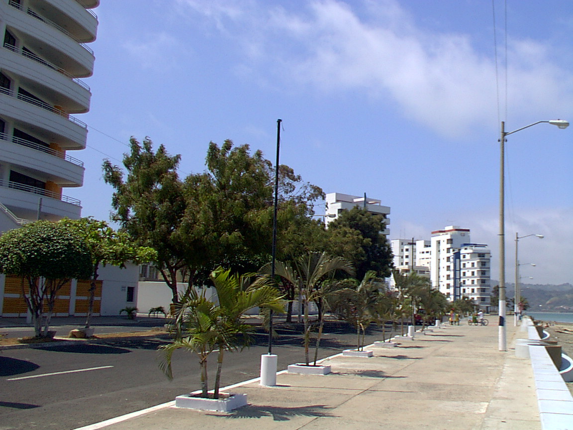
The malecón of Bahía de Caráquez runs along the edge of the city on its narrow peninsula, offering views of the Chone estuary, the bridge that links it to San Vicente and the Pacific. It is a peaceful walk, ideal for strolling, cycling, watching the sunset and enjoying the breeze, with benches, green spaces and a row of tower blocks that give Bahía a distinctive urban profile, unusual among the beach towns of the coast. The tip of the peninsula is one of the most photogenic corners: this is where the tallest buildings cluster, looking out over the water on almost every side, and where you can take in the singular geography of the city, all but surrounded by the river and the sea. The contrast between the calm of Bahía and the movement of the fishing port of San Vicente, on the other side of the river, is part of the charm of the place. The malecón also concentrates part of the city's social and food life, with restaurants and places to try Manabí seafood cooking facing the water. Getting there: it is in the city itself, reachable on foot. Best time to go: sunset, for the light over the estuary. Tips: pair the walk with a seafood meal facing the sea; it is a good spot for grasping Bahía's peculiar geography.
ℹ️ Distance: In the city itself (on foot) · Best time to go: Sunset, for the light over the estuary · Admission: Free (open promenade) · Length: 1 to 2 hours
2
Mangroves of the Chone estuary
The great mangrove ecosystem at the mouth of the Chone river, brought back by the eco-city, with birds and wildlife.
The Chone estuary, where Bahía sits, holds one of the most important mangrove ecosystems on Ecuador's central coast. After years of degradation from the spread of shrimp farms, Bahía launched, as part of its eco-city project, mangrove reforestation programs that brought back much of this vital environment, a refuge for enormous biodiversity. The mangroves are toured by boat or canoe with local guides, threading through tunnels of roots and vegetation. It is an ideal outing for watching birds (herons, frigatebirds, ibis, pelicans and many more), crabs, fish and estuary life, and for understanding the mangrove's role as a natural nursery and a barrier against erosion. These trips are usually run by local communities and associations that combine tourism with conservation. It is a quiet, rewarding experience, especially recommended for nature lovers and birdwatchers. Getting there: the trips leave from Bahía or from points on the estuary; you book them with local operators and communities. Best time to go: early morning or late afternoon, the best hours for wildlife; the tide shapes the routes (check). Tips: bring binoculars, sunscreen, repellent, water and a hat; choose responsible operators and communities.
ℹ️ Distance: Chone estuary, next to Bahía (departures by boat/canoe) · Best time to go: Early morning or late afternoon; depending on the tide (check) · Admission: Boat tour of the mangroves approx. US$ 15-30 per person (source: local operators and community tourism, verified July 2026) · Length: Half a day
3
Isla Corazón
A heart-shaped wildlife refuge in the estuary, famous for the largest frigatebird colony in the area.
Isla Corazón is a wildlife refuge in the Chone estuary, named for its shape seen from the air. It is one of the great natural attractions of the Bahía area and a site of great conservation value: it is covered in mangrove and holds an important bird colony, among them a large population of frigatebirds (the males display their inflated red throat pouch in the breeding season), along with herons and other species. The visit is made by boat or canoe from Bahía or from the community of Puerto Portovelo, and usually includes a walk along a raised wooden boardwalk about 400 meters long that heads in among the mangroves, plus a paddle through the tunnels of roots under the mangrove canopy, letting you see the wildlife and vegetation up close. The Isla Corazón project has been run since 1998 by the local fishermen's association (Asomanglar / Asociación de Servicios Turísticos Isla Corazón) and is one of the most cited examples of community tourism and mangrove conservation on the Ecuadorian coast. It is a must for anyone passing through Bahía who is keen on nature and birds. Getting there: by boat from Bahía or points on the estuary, with local operators and communities. Best time to go: depending on the tide and bird activity (ask locally); the frigatebird breeding season is especially striking. Tips: bring binoculars, repellent, sunscreen and comfortable shoes; follow the guides' instructions so as not to disturb the wildlife.
ℹ️ Distance: In the Chone estuary, opposite Bahía (by boat) · Best time to go: Depending on the tide and bird activity (ask); frigatebird breeding season · Admission: Entry to the refuge is free (open Mon-Sun 8:00-17:00); what you pay for is the community canoe/boat tour with a guide, approx. US$ 10-20 per person, which includes the paddle through the mangrove tunnels and the raised boardwalk. Trips leave from the community of Puerto Portovelo, crossing to San Vicente (source: Asociación de Servicios Turísticos Isla Corazón / Asomanglar and MAATE, market range, verified July 2026) · Length: Half a day
4
Stately architecture and the eco-city
Bahía's built heritage and its identity as an ecological city, with pioneering green projects.
Bahía de Caráquez keeps an architectural heritage that recalls its era of prosperity, tied to exporting Manabí products (coffee, cacao, rubber) through its port on the estuary. Old mansions, buildings and stately residences live alongside the modern towers on the point, giving the city an elegant, distinctive character within the Ecuadorian coast. But Bahía's great recent hallmark is its status as an 'eco-city'. After the disasters of the late 1990s (the El Niño of 1997-1998 and the 1998 earthquake), the city set out on a pioneering path of sustainability: mangrove reforestation, recycling programs, organic farming, community gardens and the promotion of ecological tourism. That bet made Bahía a reference point for environmentalism in Ecuador and drew travelers interested in responsible tourism. Walking the city lets you take in that double character: the stately seaside town of old and the community that chose to reinvent itself in a green key. Getting there: covered on foot around the city. Best time to go: any day; morning or late afternoon for pleasant walking weather. Tips: pair the architectural walk with a visit to the mangroves and Isla Corazón to understand Bahía's ecological identity.
ℹ️ Distance: In the city itself (on foot) · Best time to go: Any day; morning or late afternoon for walking · Admission: Free (open city walk) · Length: 1 to 2 hours
5
San Vicente and the bridge over the Chone river
The neighboring town on the other side of the estuary, linked to Bahía by one of the longest bridges in Ecuador.
Right opposite Bahía, on the other side of the mouth of the Chone river, is San Vicente, a town more given over to fishing and with a more working-class character. The two cities, once connected only by ferry barges (gabarras), are today joined by a long bridge over the estuary, one of the longest in the country, which is a remarkable piece of work in itself and offers magnificent views of the river, the sea and both shores. Crossing to San Vicente lets you see the contrast between peaceful, stately Bahía and the port and fishing life on the other bank. San Vicente is also the natural gateway to the north of the Manabí coast: from there the road leads to Canoa, the well-known beach and surf village, a short way off. The bridge replaced the traditional barge service that used to cross the estuary and transformed connectivity in the area, making tourism and trade easier. Getting there: the bridge links Bahía with San Vicente; you cross it by car, taxi or local transport. Best time to go: any day; at sunset, for the views from the bridge. Tips: use San Vicente as a springboard to Canoa; the views from the bridge over the estuary are among the best in the area.
ℹ️ Distance: On the other side of the Chone river, joined by the bridge (car/taxi) · Best time to go: Any day; sunset for the views from the bridge · Admission: Free (crossing the bridge) · Length: 1 to 2 hours (or passing through on the way to Canoa)
6
Trip to Canoa (beach and surf)
The relaxed beach village north of Bahía, with a long strip of sand and good waves for surfing.
Some 17 kilometers north of San Vicente (across the bridge from Bahía) lies Canoa, one of the best-loved beach villages on the Manabí coast and a classic to combine with a visit to Bahía. Canoa offers a long, wide sandy beach, surf suitable for boards (with schools and board rental), a relaxed backpacker atmosphere and cliffs framing the shore. It is an ideal destination for a day or a couple of nights: surfing, walking on the beach, watching the sunset, eating fresh seafood and enjoying a quiet, bohemian atmosphere. Near Canoa there are also caves in the cliffs that can be visited at low tide. Canoa has its own page in this guide; from Bahía it is a comfortable and highly recommended trip for adding beach and waves to your tour of the estuary. Getting there: crossing the bridge to San Vicente and then north by road (about 30-40 minutes in all from Bahía); by car, taxi or local transport. Best time to go: sunny days; for surfing, check the wave season. Tips: ideal for combining with Bahía on the same trip; bring sunscreen and, if you want to surf, ask the local schools.
ℹ️ Distance: Some 17 km north of San Vicente (30-40 min from Bahía via the bridge) · Best time to go: Sunny days; check the wave season for surfing · Admission: Free (public beach); surf lesson in Canoa approx. US$ 15-25 (source: Canoa surf schools, verified July 2026) · Length: Half a day or more
Advertisements
What nobody tells you

💵 Prices

Tickets

TypePrice
Malecón and city walk in BahíaFree (open promenade)
Tour of the mangroves of the Chone estuaryUS$ 15-30 per person by boat with a guide (source: local operators, verified July 2026)
Visit to Isla Corazón (wildlife refuge)US$ 10-20 per person, community boat tour (source: Asociación Isla Corazón y Fragatas, verified July 2026)
Crossing the Bahía–San Vicente bridge (Puente Los Caras)Free
Canoa beachFree (public beach)
Surf lesson in CanoaUS$ 15-25 per person (source: Canoa surf schools, verified July 2026)
🔄 updated monthlyOfficial / reference values · double-check when buying

Activities and tours

ActivityPriceDurationOperator
Tour of the mangroves of the Chone estuaryUS$ 15-30 per personHalf a dayOperators such as Nauticus and local communities of the estuary
Visit to Isla Corazón (frigatebird and bird watching)US$ 10-20 per personHalf a dayIsla Corazón community tourism
Whale watching (Jun-Sep, from the area)US$ 25-40 per person in season2-3 hLocal operators (Nauticus and others)
Surf and beach trip to CanoaSurf lesson US$ 15-25; transport US$ 1-3 by busHalf a day to a dayCanoa surf schools
Kayak or canoe outing on the estuaryUS$ 10-25 per person1-3 hLocal operators
🔄 updated monthlyOfficial / reference values · double-check when buying
Advertisements

🚌 How to get there and distances

Getting around

ModePriceDurationNotes
On footFreeVariableBahía is small and comfortably covered on foot: the malecón, the point and the center are a short distance apart. Ideal for walking and cycling
Taxi and mototaxiMototaxi US$ 1-2 in the city; taxi US$ 2-5 within Bahía; to San Vicente US$ 5-8 over the bridge (cash)VariableUseful for longer trips, for crossing to San Vicente or reaching the terminal. There is no Uber/Cabify: you flag them down in the street or your hotel calls one. Agree the fare before you get in; you pay in cash
Buses to San Vicente / Canoa (Coop. Costa Norte, San Vicente and others)US$ 0.35-0.75 to San Vicente; US$ 1-1.50 to Canoa; paid in cash only as you boardSan Vicente 10-15 min; Canoa 30-40 minCooperatives that cross the Puente Los Caras to San Vicente and carry on north to Canoa and the coast. They leave from the bus terminal and from central points, very frequently. They take no cards and no QR: coins or small notes
Real-time apps: Google Maps; Moovit for the Manta/Portoviejo legFree (the apps)N/ABahía has no live town-bus app. Google Maps is useful for locating the terminal and estimating interprovincial bus routes; Moovit has useful coverage in Manta and Portoviejo (the connecting hubs), but it does not track the local cooperatives crossing to San Vicente live. For real times, ask at the bus terminal or at your hotel (source: Moovit Ecuador and Terminales Ecuador, verified July 2026)
Crossing to San Vicente over the Puente Los CarasFree (there is no toll for crossing the bridge); by car/bus/taxi 5-6 min, on foot ~20 min along the pedestrian and cycle path5-6 min by vehicleSince 2010 the Puente Los Caras (1,980 m, the longest in Ecuador) has replaced the old barges that crossed the estuary. It has lanes for cars, a cycle path and a footway, with balcony lookouts. There is NO longer a regular barge service; the boats that remain are for mangrove and Isla Corazón tours, not for the everyday crossing (source: Ministerio de Transporte y Obras Públicas / Wikipedia Puente Los Caras, verified July 2026)
🔄 updated monthlyOfficial / reference values · double-check when buying

How to get there

RouteAirlines / operatorsAvg. priceDuration
Manta → Bahía de Caráquez (bus)Reina del Camino, Coactur and Manabí cooperativesUS$ 3-5 per personApprox. 2 to 2.5 h
Portoviejo → Bahía de Caráquez (bus)Local Manabí cooperativesUS$ 2.50-4 per personApprox. 1.5 to 2 h
Guayaquil → Bahía de Caráquez (bus)Reina del Camino, CoacturUS$ 6-9 per personApprox. 5 to 6 h
Quito → Bahía de Caráquez (bus)Reina del Camino and interprovincial cooperativesUS$ 10-14 per personApprox. 8 to 9 h
Canoa / San Vicente → Bahía (bus/taxi over the bridge)Local cooperatives and taxisUS$ 1-2 by bus; US$ 8-12 by taxi from CanoaApprox. 30-40 min from Canoa
🔄 updated monthlyOfficial / reference values · double-check when buying

🏨 Where to stay

No exact prices: a scale from $ (budget) to $$$$$ (luxury), with 2-3 options per category.

CategoryPriceRecommended options
Budget / hostels$$$$$Cheap guesthouses and hotels in Bahía and in nearby Canoa: approx. US$ 15-35 a night; chosen by backpackers and travelers working their way along the coast
Mid-range hotels in the city$$$$$Mid-range hotels and inns in the center and near the malecón: approx. US$ 35-70 a night; good value for the location if you want to explore the city and the mangroves
Ecological lodging / sustainable tourism$$$$$In tune with the eco-city identity, nature-oriented lodgings: approx. US$ 40-90 a night; e.g. Saiananda Adventure Eco Lodge, surrounded by nature
Higher-end / boutique hotels$$$$$Boutique and luxury hotels with sea views, a pool and a spa: approx. US$ 90-180 a night; e.g. Casa Ceibo Boutique Hotel & Spa, Buenavista Place Hotel

🍴 Where to eat

TypePriceOptions / signature dish
Typical Manabí food and local eateries$$$$$Manabí criollo cooking built on peanut, green plantain and fish: bollos, corviche, broths and set dishes of the day at eateries and markets: approx. US$ 3-7 a dish
Ceviche places and Manabí seafood cooking$$$$$Fish and shrimp ceviches, encebollado, viche and fresh fish from the estuary and the sea, on the malecón and in the center: approx. US$ 6-15 a dish
Restaurants with estuary views$$$$$Restaurants on the malecón and the point where you can eat seafood and criollo cooking with views over the Chone river: approx. US$ 8-18 a dish; e.g. Coco Bongo
Boutique hotel restaurants / healthy options$$$$$At boutique hotels and healthy or vegetarian places (in line with the eco-city): approx. US$ 15-28 a dish or set menu
Advertisements

📖 History of Bahía de Caráquez

Origins, formation and what the sources say.

The pre-Hispanic peoples of the Chone estuary

Few cities in Ecuador carry their history in the very name of an archaeological culture: the 'Bahía culture', which flourished on this coast more than two thousand years ago, is named precisely after this corner of the Chone estuary. Long before the Spanish arrived, the peninsula where Bahía de Caráquez stands today was inhabited by peoples of the Manabí coast, heirs to a long tradition of seafarers and sea traders. The area was part of the development zone of very ancient coastal cultures, among them the Bahía culture itself (which gives its name to an archaeological period on the Ecuadorian coast) and, later, the Manteña culture.

These peoples made the most of the extraordinary wealth of the estuary and the mangroves: they fished, gathered shellfish and crustaceans, and traded along the coast. The mangroves, today valued again for their ecological importance, were already then a natural larder and a key environment for the life of these communities. The Spondylus shell, so prized in the pre-Hispanic world, moved along these shores within the Manteña exchange networks.

The singular geography of the place —a peninsula between the river and the sea— offered abundant resources and a strategic position over the estuary at the same time, which explains the human presence in the area from very remote times.

The Bahía culture and the name of the archaeological period
The 'Bahía culture' is one of the archaeological cultures of the Ecuadorian coast, and its name comes precisely from this region. The exact relationship between the different coastal peoples (Bahía, Jama-Coaque, Manteña) and their continuity is a matter of archaeological study.
Source: https://es.wikipedia.org/wiki/Cultura_Bah%C3%ADa

The origin of the name: the 'caras' or 'caráquez'

The name 'Caráquez' points back to the ancient 'caras' or 'caráquez', a people of the Manabí coast that Ecuadorian historical tradition links to one of the most famous —and most debated— accounts of how the country's Andes were settled. According to that account, taken up by chroniclers and historians, the caras are said to have arrived by sea on these shores and, from here, to have migrated into the Andean interior, where they would join what is called the Kingdom of Quito of the Shyris. The bay of the estuary would have been, in that narrative, the landing point of that people.

This story, spread above all by the colonial chronicler Juan de Velasco in the 18th century, was for a long time part of the traditional account of the origins of pre-Hispanic Ecuador. Modern historiography, however, treats it with caution and considers it largely legendary or unproven archaeologically, so today it is presented more as tradition than as established fact.

What did stick was the place name: the region and the town inherited the name of those 'caráquez', and the city came to be called Bahía de Caráquez, keeping in its name the trace of that ancient coastal tradition.

The account of the caras and the Kingdom of Quito (Juan de Velasco)
The idea that the caras landed on this coast and migrated towards the Andes, joining the Kingdom of Quito of the Shyris, comes largely from the chronicle of the Jesuit Juan de Velasco (18th century). Current historiography considers this account largely legendary and lacking solid archaeological backing, so it should be taken with caution.
Source: https://es.wikipedia.org/wiki/Reino_de_Quito
The place name 'Caráquez'
The city's name derives from the 'caras' or 'caráquez', a coastal people of the region. Beyond the debate about the migrations, the place name became permanently attached to the bay and to the town.
Source: https://es.wikipedia.org/wiki/Bah%C3%ADa_de_Car%C3%A1quez

The port and the export prosperity of the 19th century

During the colonial period, the Chone estuary area was a secondary point on the Manabí coast, given over to fishing and small-scale trade. The town of Bahía de Caráquez took shape as a city above all in the 19th century, already in the republican era, when its port on the estuary became important for the regional economy.

Bahía then lived through a period of prosperity tied to exporting the products of Manabí farming: coffee, cacao and, at certain moments, rubber and other goods left through its port for other destinations. That boom left its mark on the city, which acquired old mansions, residences and stately buildings, a reflection of the families and the trade that flourished in the warmth of the export business.

The city became the seat of the canton of Sucre, within the province of Manabí, and settled into its profile as an elegant, quiet town, different from the busier ports of the coast. Its position on the tip of the peninsula, almost surrounded by water, finished defining its singular character within the Ecuadorian shoreline.

The export boom and the stately architecture
Bahía's prosperity in the 19th and early 20th centuries was tied to its port and to the export of Manabí products (coffee, cacao, rubber). That boom explains the city's stately architectural heritage. The exact volumes and periods of the export boom vary from source to source.
Source: https://es.wikipedia.org/wiki/Bah%C3%ADa_de_Car%C3%A1quez

The disasters of 1997-1998 and the birth of the eco-city

The most decisive stretch of the recent history of Bahía de Caráquez came in the late 1990s, when the city suffered two natural blows in a row. First, the devastating El Niño event of 1997-1998, which brought torrential rain, overflowing rivers, landslides and flooding to the Ecuadorian coast, with serious damage in the area. And shortly afterwards, on 4 August 1998, a strong magnitude 7.2 (Mw) earthquake, with its epicenter barely 3 km from the city, shook the region and seriously damaged buildings and homes: this was the 1998 Bahía de Caráquez earthquake.

Faced with that double disaster, instead of simply rebuilding what had been lost, part of the Bahía community pushed a novel idea: to refound the city under an ecological paradigm. So, on 23 February 1999, Bahía officially declared itself an 'eco-city' and began developing initiatives that were pioneering in Ecuador: programs to reforest the degraded mangroves of the estuary, waste separation and recycling, organic farming, community gardens and allotments, ecological taxis and the creation of the 'Bosque en Medio de las Ruinas', a small dry-forest reserve raised on the rubble left by El Niño.

That bet made Bahía a reference case for environmentalism in the country and gave it a particular identity, closely tied to the recovery of its natural setting. The mangrove reforestation and the creation of wildlife refuges such as Isla Corazón sit within that vision, which combines conservation, community participation and responsible tourism.

El Niño 1997-1998 and the 1998 earthquake as triggers
The sources agree that the disasters of the late 1990s were the trigger for the eco-city project in Bahía de Caráquez. The Instituto Geofísico of the Escuela Politécnica Nacional dates the earthquake to 4 August 1998, with a magnitude of 7.2 (Mw), an epicenter about 3 km from the city and an intensity of VIII on the Mercalli scale. Bahía declared itself an eco-city on 23 February 1999.
Source: https://www.igepn.edu.ec/servicios/noticias/457-sismo-de-bah%C3%ADa-de-car%C3%A1quez-4-de-agosto-de-1998

The 2016 earthquake and Bahía today

The history of Bahía de Caráquez crossed paths with the force of nature again on 16 April 2016, when a magnitude 7.8 earthquake, with its epicenter on the Manabí coast (the Pedernales-Cojimíes area), shook the whole province. The quake —the most destructive in Ecuador in decades— caused many deaths and severe damage in towns such as Pedernales, Manta, Portoviejo and Canoa, and also affected Bahía de Caráquez, which already carried the experience of the 1998 earthquake.

The region set out on a long process of reconstruction, with national and international help, to recover housing, infrastructure and tourism. Bahía, true to its quiet profile, gradually picked up its daily life again and its role as a peaceful destination of nature, mangroves and rest.

Today, Bahía de Caráquez combines several layers of its history: the legacy of the pre-Hispanic coastal peoples, the export prosperity reflected in its stately architecture, the eco-city identity born of the disasters of the 1990s and the resilience shown in the face of earthquakes. It is a city that invites you to slow down, to explore its mangroves and its estuary, and to understand how a coastal community chose to reinvent itself in a green key in the face of adversity.

The impact of the 2016 earthquake in Manabí
The earthquake of 16 April 2016 (magnitude 7.8) seriously affected the province of Manabí, with its epicenter in the Pedernales-Cojimíes area. Bahía de Caráquez, like other towns on the coast, suffered damage and took part in the reconstruction process. The figures for deaths and damage were refined over time in official reports.
Source: https://es.wikipedia.org/wiki/Terremoto_de_Ecuador_de_2016

📚 Bibliography

  • Wikipedia (ES) — «Bahía de Caráquez»: https://es.wikipedia.org/wiki/Bah%C3%ADa_de_Car%C3%A1quez
  • Wikipedia (ES) — «Cantón Sucre (Ecuador)»: https://es.wikipedia.org/wiki/Cant%C3%B3n_Sucre_(Ecuador)
  • Wikipedia (ES) — «Cultura Bahía»: https://es.wikipedia.org/wiki/Cultura_Bah%C3%ADa
  • Wikipedia (ES) — «Cultura manteña»: https://es.wikipedia.org/wiki/Cultura_mante%C3%B1a
  • Wikipedia (ES) — «Reino de Quito»: https://es.wikipedia.org/wiki/Reino_de_Quito
  • Wikipedia (ES) — «Terremoto de Ecuador de 2016»: https://es.wikipedia.org/wiki/Terremoto_de_Ecuador_de_2016
  • Wikipedia (ES) — «Terremoto de Bahía de Caráquez de 1998»: https://es.wikipedia.org/wiki/Terremoto_de_Bah%C3%ADa_de_Car%C3%A1quez_de_1998
  • Instituto Geofísico (EPN) — «Sismo de Bahía de Caráquez: 4 de agosto de 1998»: https://www.igepn.edu.ec/servicios/noticias/457-sismo-de-bah%C3%ADa-de-car%C3%A1quez-4-de-agosto-de-1998
  • Isla Corazón y Fragatas (turismo comunitario): https://www.islacorazonyfragatas.com/
  • Wikipedia (ES) — «Provincia de Manabí»: https://es.wikipedia.org/wiki/Provincia_de_Manab%C3%AD

❓ Frequently asked questions

Why do they call Bahía de Caráquez an 'eco-city'?+
After two natural disasters in the late 1990s (the El Niño event of 1997-1998 and a strong earthquake in 1998), Bahía decided to reinvent itself and declared itself an eco-city, driving pioneering sustainability projects: mangrove reforestation, recycling, organic farming, community gardens and ecological tourism. That green bet made it a reference point for environmentalism in Ecuador.
What is there to do in Bahía besides the beach?+
Bahía is more estuary and nature than open beach. The unmissable thing is touring the mangroves of the Chone river and visiting Isla Corazón, with its big colony of frigatebirds and other birds. It is also worth walking the malecón and the point, taking in the stately architecture, crossing the bridge to San Vicente and making a trip to the beach at Canoa, to the north.
How do I get to Canoa from Bahía?+
You have to cross the bridge over the Chone river to San Vicente and from there carry on by road some 17 kilometers north to Canoa: about 30-40 minutes in all. You can do it by local transport (buses/cooperatives), taxi or your own car. Canoa is a beach and surf trip well worth combining with Bahía.
Is Isla Corazón worth visiting?+
Yes, above all if you like nature and birds. Isla Corazón is a wildlife refuge in the estuary, covered in mangrove, famous for its frigatebird colony (the males inflate their striking red pouch in the breeding season) and other birds. You visit it by boat from Bahía, with a raised boardwalk among the mangroves, on a community tourism and conservation project.
Was Bahía affected by the 2016 earthquake?+
Yes. The earthquake of 16 April 2016 (magnitude 7.8), with its epicenter on the Manabí coast, affected the whole province, including Bahía de Caráquez, which had already suffered a major quake in 1998. The region has been rebuilding ever since, and the city still works as a quiet destination for nature and rest.
How many days is it worth staying in Bahía?+
One or two days are enough to see the city, the malecón, the mangroves and Isla Corazón. If you want to add beach and surf, 2 or 3 days lets you combine Bahía with Canoa and explore a bit more of the Manabí coast. It is a destination for slowing down, so many travelers enjoy staying a little longer for its quiet atmosphere.
How do you cross from Bahía de Caráquez to San Vicente?+
Over the Puente Los Caras, the longest bridge in Ecuador (1,980 m), opened in 2010. You cross it by car, taxi or bus in 5-6 minutes, or on foot in about 20 minutes along its footway and cycle path, and there is no toll to cross. Before the bridge you had to use gabarras (barges) that could take hours; today that crossing service no longer exists. A bus to San Vicente costs US$ 0.35-0.75 and a taxi about US$ 5-8, always in cash.
How do you pay for the bus in Bahía and is there an app to see it in real time?+
Transport is paid in cash: the local buses and the interprovincial cooperatives take no cards, QR or payment apps; you pay as you board, with coins or small notes. There is no app that tracks the local buses live; Google Maps helps you locate the bus terminal and estimate routes, and Moovit works for the Manta and Portoviejo legs. For exact times, the best thing is to ask at the Bahía bus terminal.
Sources consulted (18)
Still planning?
Explore more destinations in Ecuador
See all destinations →
Advertisements
Image credits
Photos from Wikimedia Commons, each under its own licence (CC BY, CC BY-SA or public domain). Open each file to see its author and licence.
Malecón de Bahía de Caráquez