Viajá con Gus
HomeArgentinaEl Calafate
El Calafate
🇦🇷 Argentina · Patagonia

El Calafate

Jump to what you need
📌Province
Santa Cruz, at the far south of Argentine Patagonia. El Calafate is the gateway to the southern sector of Los Glaciares National Park, declared a Unesco World Heritage Site in 1981. It sits on the shore of Lake Argentino, the largest lake in the country, right in the Patagonian steppe with the Andes rising alongside.
📌Service city
El Calafate works as the logistics base for visiting the Perito Moreno Glacier and for boat trips on Lake Argentino. Hotels, hostels, tour agencies, grills and shops are concentrated along Avenida del Libertador, its main artery. It has its own airport (FTE, Comandante Armando Tola) and daily connections with Buenos Aires. From here you can also drive to El Chaltén, the national trekking capital, about 215 km away.
📌Best time to go
The southern summer (December to March) brings the longest days, mild temperatures and every excursion running, but it's high season, with prices and demand at their peak. Spring (October-November) and autumn (April, with the lenga forests turning red) are excellent alternatives with fewer people. In winter (June-August) the pace slows, but the glacier is still visitable and the snowy landscapes are spectacular; bring warm clothes and check for reduced hours.
📌Suggested days
The reasonable minimum is 3 full days: one for the Perito Moreno Glacier and its walkways, another for a boat trip on Lake Argentino (the Upsala and Spegazzini glaciers) or the mini-trek on the ice, and a third for the town, the Glaciarium and the Laguna Nimez Reserve. If you add a side trip to El Chaltén to trek to Fitz Roy, set aside 5 to 7 days for the region.
💱 ARS exchange rate
Loading rate…
🌤️ Weather in El Calafate
Loading weather…

El Calafate is one of those destinations that justify a trip to Patagonia all on their own. Looking out over the turquoise water of Lake Argentino, this town in Santa Cruz province grew at the pace of tourism until it became the base from which almost everyone visits the famous Perito Moreno Glacier. Its name comes from a humble thorny shrub with blue berries, the calafate, and from an old Tehuelche legend promising that whoever eats its fruit will always return to Patagonia.

What makes El Calafate unique is how close it is to one of the most striking natural wonders on the planet: Los Glaciares National Park, a Unesco World Heritage Site. Barely 80 kilometers away, the face of the Perito Moreno rises some 70 meters above the water and, every so often, puts on the spectacle of ice blocks calving into the lake with an unforgettable roar. This is no ordinary glacier: it advances, dams an arm of the lake and, periodically, breaks its own ice bridge in a phenomenon that draws the curious from all over the world.

But El Calafate is much more than its glacier. It's sailing between icebergs toward the Upsala and Spegazzini glaciers, walking in crampons on the blue ice, wandering the Laguna Nimez Reserve among flamingos, learning glaciology at the modern Glaciarium museum and closing the day with spit-roasted Patagonian lamb and a glass of wine. A warm guide to help you make the most of every day in this corner of the end of the world.

📖 History of El Calafate

Long before the town existed, the land around Lake Argentino was the territory of the Tehuelche (Aónikenk), nomadic hunters who moved across the Patagonian steppe following the guanaco and the rhea. The lake was named "Argentino" by the explorer Francisco Pascasio Moreno on 15 February 1877. In the early 20th century the area was a crossing point for carters hauling wool to the port; near a large calafate shrub known as "la mata grande" (the big bush), the Pantín and Freile families set up a general store and lodging house around 1913, which gave rise to a waystation. The national government officially created the town by decree on 7 December 1927, the date taken as its founding, to consolidate settlement of the region. For decades El Calafate was a quiet ranching town, until the creation of Los Glaciares National Park (1937), its World Heritage designation (1981) and the tourism boom at the end of the century turned it into the main tourist center of southern Patagonia. The full story is on our history page.

Read the full history ↓

🏛️ El Calafate is in Santa Cruz

The immense province of southern Patagonia: Tehuelche land of the Cueva de las Manos, of the endless steppe and the sheep, of the tragic Patagonia Rebelde, of the glaciers of Perito Moreno and Fitz Roy, with El Calafate and El Chaltén as the gateways to a world of ice.

Read the history of Santa Cruz →

🗺️ What to see

1
Perito Moreno Glacier and the walkways
The absolute star. About 80 km from town, inside Los Glaciares National Park, this colossus of ice presents a face some 5 km wide and around 70 meters high above the water. A system of walkways and balconies on several levels, on the Magallanes Peninsula, lets you take it in head-on and hear the ice crack and the blocks fall into the Canal de los Témpanos. Give it several hours and be patient if you want to witness a calving.
The Perito Moreno Glacier is, quite simply, the reason half the world travels to this corner of Patagonia. About 80 km from El Calafate, inside Los Glaciares National Park, this living colossus rises with a face some 5 km wide and close to 70 meters high above the water (plus another 100 meters below the surface). What makes it unique isn't just its size but its dynamism: the ice advances several meters a day, and that constant movement is what produces the famous calvings, blocks the size of buildings crashing into the Canal de los Témpanos with a roar that echoes around the whole amphitheater. For decades it was considered one of the few glaciers in the world in balance, though since 2019 scientists have documented an accelerating retreat of its face (in 2025 it was some 385 meters, the largest on record), one more reason to see it sooner rather than later. The visit is made along a system of metal walkways and balconies spread over different levels on the Magallanes Peninsula, facing the glacier wall. There are close to 5 km of walkways divided into circuits (central, lower, shore and forest) that let you see it from multiple angles: the Main Balcony, a few meters from the entrance, gives the most striking head-on view of the north and south walls and of the dammed section. Walking all the circuits at an easy pace takes between 2 and 4 hours, and it's worth doing without rushing: the show is in listening and waiting. Calvings don't run to a timetable; you need patience, an attentive ear and your camera ready. To get there, Provincial Route 11 links El Calafate with the glacier over some 80 km of asphalt in good condition, passable all year. You can go on a scheduled agency transfer (the most convenient option if you don't rent a car), on a guided tour or in your own car. Entry to Los Glaciares National Park is paid separately and is almost never included in the transfer, with different rates for foreigners, Argentine residents and Santa Cruz residents; since the amounts in pesos change with inflation, check the current price on the official National Parks website before you travel. The best time to go is relative: in summer (December to March) there are more daylight hours, milder weather and every service running, but also more people; in autumn the lenga forests turn red and there are fewer tourists; in winter the glacier is still visitable, with spectacular snowy landscapes and fewer visitors. Always bring warm layers, a windbreaker and rain gear: the Patagonian weather changes in minutes, and it's always cold in front of the ice. Go very early or stay until mid-afternoon for better light and better odds of seeing ice fall.
ℹ️ Distance: ~80 km from El Calafate via RP11 (asphalt, year-round) · Face: ~5 km wide and ~70 m high above the water · Walkways: ~5 km of circuits on the Magallanes Peninsula; 2 to 4 hrs to walk · Park admission: Separate, not included in the transfer (check rates because of inflation)
2
Mini-trekking on the glacier
The most iconic ice-walking excursion. After crossing the Brazo Rico by boat and walking along the lateral moraine, you're fitted with crampons, helmet and poles to cross the glacier surface for about an hour and a half, discovering blue crevasses, moulins and small internal pools that change from day to day. Run by Hielo y Aventura; suitable for most visitors with basic fitness.
The Mini-trekking is, for many, the unforgettable El Calafate experience: walking on the Perito Moreno itself, crampons on your feet, listening to the ice crack under your boots. It's how you go from looking at the glacier to being inside it. The trip starts with a short crossing of the Brazo Rico of Lake Argentino, which in itself gives you a view of the glacier's south wall from the water, and lands on the far shore, at the foot of the ice. From there you walk along the lateral moraine (the stony path at the glacier's edge) to the point where the guides hand out and fit the crampons, helmet and poles, and explain the basic technique for walking on ice. Then come about an hour and a half up on the glacier, in small groups and always with guides, discovering a landscape that changes every day: deep blue crevasses, small streams running across the surface, moulins where the water plunges away with force, and internal pools of an unreal color. It usually ends with a toast of whisky over glacier ice, a classic. The activity is run exclusively by the concession holder Hielo y Aventura and is suitable for most visitors with basic fitness (walking for several hours, going up and down). There's a recommended age range (generally from teenagers up to a certain maximum) worth confirming when you book. No previous mountain experience is needed: the crampons and the technique are taught on the spot. It's a full day and worth booking ahead, especially in high season, because places are limited. The price is paid separately from National Park admission, which you also have to pay (amounts in ARS subject to inflation; check). Key recommendations: bring warm layers, a waterproof windbreaker, gloves, a hat, sunscreen and sunglasses (the glare off the ice is intense), sturdy trekking boots and some food, since you spend several hours outdoors. You can't do it in lightweight footwear or without the right clothing.
ℹ️ Walk on the ice: ~1 h 30 with crampons, helmet and guides · Operator: Hielo y Aventura (exclusive concession holder) · Total duration: Full day (boat crossing + moraine + trek) · Requirements: Basic fitness and an age range (confirm when booking)
3
Big Ice
The extended, demanding version of the glacier trek: close to 4 hours walking on the ice, pushing into the heart of the Perito Moreno among seracs, deep crevasses and formations of intense blue ice. It requires better fitness and has an age limit. For adventurers who want the fullest experience on the glacier.
Big Ice is the Mini-trekking's older, far more demanding sibling: instead of an hour and a half, it's close to 4 hours walking on the ice, pushing into the heart of the Perito Moreno, far from the shore, where the glacier shows its most imposing face. Here you cross seracs (ice towers), deep crevasses, ice caves (when conditions allow) and formations of intense blue that you only see once you're deep in the ice mass. It's the fullest and most spectacular experience on the glacier, designed for those who want to go further. Like the Mini-trekking, it's run by Hielo y Aventura and includes the crossing of the Brazo Rico and an approach walk, but the day is longer (it usually takes up most of the day, several hours of it on the ice). The physical effort is considerable: you have to walk and climb ice slopes for hours, so it requires good fitness and isn't for everyone. The restrictions are stricter than for the Mini-trekking. The age range is narrower (generally no one under a certain age nor over a limit worth confirming) and it isn't advisable for people with heart or mobility problems, or for pregnant women. The guides assess conditions and may adjust the route depending on the weather and the state of the ice. Since places are limited and demand is high, book well ahead. It's paid separately from National Park admission (amounts in ARS subject to inflation; check). The same recommendations on gear and clothing as for the Mini-trekking apply, but even more so: warm layers, rain gear, gloves, a hat, sunglasses and plenty of food, because you spend many hours in the cold and the glare off the ice wears you down. If it's your first time on a glacier and you're unsure of your fitness, the Mini-trekking is still the best way in.
ℹ️ Walk on the ice: ~4 hrs, pushing into the heart of the glacier · Operator: Hielo y Aventura (exclusive concession holder) · Difficulty: High; requires good fitness and falls within a narrow age range · Tip: Book well ahead; places are limited
4
Boat trip to the Upsala and Spegazzini glaciers
A full-day excursion (usually leaving from Puerto La Soledad / Punta Bandera) that sails Lake Argentino among huge icebergs to approach the imposing Upsala Glacier and the Spegazzini, which has the tallest face in the park. A different way to grasp the scale of the Southern Patagonian Ice Field, with landscapes of floating icebergs that change shape every season.
If the Perito Moreno is the glacier you walk on, the boat trip to the Upsala and Spegazzini glaciers is the excursion for grasping the true scale of the Southern Patagonian Ice Field, the third largest freshwater reserve on the planet. It's a full day aboard catamarans that sail from Punta Bandera (Puerto La Soledad), about 50 km from El Calafate, and cruise the northern arms of Lake Argentino among floating icebergs calved from the glaciers, which change shape, size and color every season, drifting like blue sculptures. The Upsala is one of the largest glaciers in South America and, although it has retreated considerably in recent decades, its face and the enormous icebergs it releases are still impressive; often the boat can't get too close because of the sheer amount of floating ice, which gives you a sense of its scale. The Spegazzini, by contrast, has the tallest face in the park (its walls comfortably exceed the Perito Moreno's in height) and the boat gets fairly close to it, in an amphitheater of mountains and forest. Unlike the Perito Moreno, you don't walk on the ice here: the experience is from the water, which makes it comfortable and suitable for all ages, including children and older travelers. Some versions of the trip combine the cruise with a walk or a visit to an estancia. The excursion takes practically the whole day, so bring food or check whether onboard service is included. You book it with the licensed boat operators on Lake Argentino, and National Park admission is paid separately (amounts in ARS subject to inflation; check). Recommendations: warm layers, a windbreaker and rain gear (it's very cold and windy on deck), sunscreen, sunglasses and a charged camera, because between the icebergs and the ice walls the photos never end. It's an excellent choice for a second day, complementing the Perito Moreno walkways.
ℹ️ Departure: Punta Bandera (Puerto La Soledad), ~50 km from El Calafate · Glaciers: Upsala (one of the largest in South America) and Spegazzini (tallest face in the park) · Duration: Full day; no walking on ice (suitable for all ages) · Bring: Warm layers, a windbreaker, sunglasses; park admission separate
5
Boat trip in front of the Perito Moreno (Safari Náutico)
Shorter trips (around 1 hour) that approach the south wall of the Perito Moreno by water, letting you appreciate its height and color from lake level, at a safe distance from the calvings. A good complement to the walkways.
The Safari Náutico is the perfect, accessible complement for anyone visiting the Perito Moreno walkways who also wants to see it from the water. These are short trips, around 1 hour, leaving from Puerto Bajo de las Sombras (a few kilometers from the walkway area, inside the National Park) and approaching the glacier's south wall across the lake, always keeping a safe distance because of the calvings. What this trip adds is the view from below: being at water level in front of a 70-meter wall of ice lets you really grasp its height, appreciate the deepest blues in the crevasses and see up close the icebergs floating after calving. It's a different experience from the walkways, where you look at the glacier from solid ground and from above. The activity is short, comfortable and suitable for all ages, since it only involves boarding the catamaran and enjoying the ride. Because it's brief, it combines very easily with a visit to the walkways on the same day: many travelers do the Safari Náutico first and then spend the rest of the day walking the balconies, or the other way round. You book it with the licensed operators and, as with all the other activities, National Park admission is paid separately (amounts in ARS subject to inflation; check). Bring warm layers and a windbreaker, because on the water and in front of the ice it's always cold, even on a sunny day. It's a good alternative for those not doing the Mini-trekking who still want closer contact with the glacier than the walkways give.
ℹ️ Departure: Puerto Bajo de las Sombras (inside the park, next to the walkways) · Duration: Around 1 hour · What it adds: A view of the Perito Moreno at water level, from below · Ideal: Combine it with the walkways on the same day; suitable for all ages
6
Glaciarium - Patagonian Ice Museum
A modern museum a few kilometers from the center devoted to glaciology and the Southern Patagonian Ice Field. Interactive displays explain how glaciers form, advance and retreat, and why the Perito Moreno is so special. It also has the GlacioBar, an ice bar. Open all year, with reduced hours in the winter months. Ideal for understanding what you see in the park.
The Glaciarium is one of those museums that transforms a visit to a destination: after coming here, you look at the Perito Moreno and the glaciers with different eyes. It's a modern glaciology museum, the only one of its kind in Argentina, about 6 km from the center of El Calafate, in a designed building that evokes a block of ice on the steppe. It's devoted entirely to the Southern Patagonian Ice Field and the world of glaciers. Through rooms with interactive displays, models, audiovisuals and a 3D cinema, it explains clearly and entertainingly how glaciers form, why they advance and retreat, what an ice field is, how the famous rupture cycle of the Perito Moreno works and what glaciers tell us about climate change. It's ideal for understanding what you see in the park, and especially worth doing before you visit the glacier, so you arrive with the context in place. One of its most enjoyable attractions is the GlacioBar, a bar built entirely of ice (walls, counter, glasses and sculptures), which you enter bundled in a thermal cape and gloves provided by the museum, at below-freezing temperature, to have a drink in ice glasses. It's an experience that tends to delight children and adults alike, and it's paid separately from general admission. The Glaciarium is open all year, with reduced hours in the winter months, and has its own admission (amounts in ARS subject to inflation; check its website). It offers a free or low-cost transfer service from the center of El Calafate, which makes it very accessible without a car. It's a 1 to 2 hour visit, perfect for a day of bad weather or for complementing the glacier excursions with the scientific and educational side.
ℹ️ What it is: A glaciology museum of the Southern Patagonian Ice Field · Location: ~6 km from the center; with a transfer from El Calafate · Plus: The GlacioBar, an ice bar (separate admission) · Duration: 1 to 2 hrs; open all year (reduced hours in winter)
7
Laguna Nimez Nature Reserve
Steps from the center, on the shore of Lake Argentino, this wetland reserve is a paradise for birdwatching: Chilean flamingos, black-necked swans, ducks, geese and ibises along a flat, quiet trail circuit. Perfect for a relaxed walk at dusk and for lovers of nature and photography.
The Laguna Nimez Nature Reserve is El Calafate's green secret, steps from the center and often overlooked amid all the glacier excursions. It's a protected wetland area on the shore of Lake Argentino, just north of town, that works as a bird refuge and as a pocket of quiet nature you can walk to from the center in about 15 to 20 minutes. It's a paradise for bird and photography lovers. Across its lagoons and grasslands you'll see Chilean flamingos (their pink shapes on the water with the Andes behind is one of the local postcards), black-necked swans, ducks of several species, geese, ibises, lapwings and, with luck, a bird of prey. The trail circuit is flat, well signposted and takes one to two hours, with viewpoints and interpretive signs that help identify the species. The best thing about Laguna Nimez is how accessible and calm it is: you don't need a tour or a vehicle, it's suitable for all ages and it's perfect for a relaxed walk, especially at dusk, when golden light washes over the lagoon and the birds gather. It's an excellent way to fill half an afternoon, to rest from the intense excursions or simply to enjoy the lake without leaving town. The reserve has a low-cost admission that usually includes a bird guide leaflet (amounts in ARS subject to inflation; check at the entrance) and opening hours worth confirming, since they can vary with the season and the daylight. Recommendations: bring binoculars if you have them, warm layers and a windbreaker (the wind off the lake is cold), and comfortable shoes. It's one of those places that prove El Calafate is much more than its glacier.
ℹ️ What it is: A wetland reserve and bird refuge on Lake Argentino · Location: 15-20 min on foot from the center · Wildlife: Flamingos, black-necked swans, ducks, geese and ibises · Tip: Best at dusk; bring binoculars and warm layers; low-cost admission
8
Bahía Redonda and the Lake Argentino waterfront
The edge of Lake Argentino beside town, where the waterfront invites you to walk, photograph the turquoise water with the Andes behind and watch birds. It's the easiest place for a first contact with Argentina's largest lake without leaving the center.
Bahía Redonda is El Calafate's balcony onto Lake Argentino, the largest lake in the country, and the easiest and cheapest way to make first contact with this enormous glacial body of water. It's the shoreline area beside town, where a promenade and footpaths run along the water's edge, with benches, viewpoints and signs, ideal for an effortless walk and for photographing the turquoise water with the snowy Andes behind. The bay is part of the same wetland system as the Laguna Nimez Reserve and is, in fact, another excellent spot for birdwatching: you'll see flamingos, black-necked swans, ducks and other water species that frequent the shore. The lake's characteristic milky turquoise comes from 'glacial flour', the extremely fine rock dust that glaciers grind out and keep suspended in the water. It's a perfect plan for the end of the day: the dusk light on the lake and the mountains produces some of the best photos in El Calafate, and since it's right by the center you can walk there in minutes. There's no admission to pay and nothing to book; just head to the waterfront and enjoy it. One tip: the Patagonian wind blows hard and cold on the lakeshore almost all year, so bring warm layers and a windbreaker even if it's sunny. It's a quiet, accessible, free place to rest between excursions or to close out the day looking at the water.
ℹ️ What it is: The promenade and shore of Lake Argentino beside town · Access: Free, a few minutes on foot from the center · Ideal for: Walking, photos at dusk and birdwatching
9
The center and Avenida del Libertador
The main avenue is packed with restaurants, grills, chocolate shops, regional produce stores, travel agencies and craft shops. It's the social heart of town, with its wood and stone architecture, ideal for an evening stroll, for buying souvenirs and for tasting calafate preserves and liqueurs.
Avenida del Libertador General San Martín is the backbone of El Calafate and the social heart of town. Along its few central blocks almost all the life is concentrated: restaurants and grills serving Patagonian lamb, chocolate shops, regional produce stores, travel agencies, craft and mountain clothing shops, wine shops and cafés. This is where the town's pulse beats, especially in the late afternoon, when people come out to stroll, eat and shop. What characterizes the avenue is its wood and stone architecture, Patagonian-alpine in style, with warm facades that give it the air of a mountain town despite sitting in open steppe. Wandering here without rushing, going into the chocolate shops to try truffles and into the regional produce stores to taste calafate preserves and liqueurs (the blue fruit that gives the place its name and which, according to the Tehuelche legend, brings whoever eats it back to Patagonia), is part of the experience. It's the ideal place to buy souvenirs: textiles, leather and silver crafts, products bearing the glacier's image, and the inevitable calafate and other berry preserves, jams and liqueurs to take home as gifts. Almost all the central accommodation is a few blocks from the avenue, so you can cover it all on foot. At night the avenue fills with movement and it's time to go out for spit-roasted lamb or to try contemporary Patagonian cooking. You don't need anything special to enjoy it, just the urge to walk and browse; do book a table at the most sought-after restaurants in high season, though. It's the perfect urban and culinary counterpoint to the days spent in nature.
10
Patagonian estancias
In the surrounding area you can visit traditional estancias that combine rural history, horseback rides, shearing demonstrations and, above all, the classic spit-roasted Patagonian lamb. A way to get to know the ranching life of the steppe and the hospitality of Santa Cruz.
Visiting a Patagonian estancia means glimpsing the rural soul of Santa Cruz, the one that existed long before tourism discovered the glaciers. Around El Calafate there are traditional estancias — many of them a century old, built by pioneers who filled the steppe with sheep in the early 20th century — that open their gates to visitors to share a 'day in the country' with history, landscape and criollo food. The typical experience combines several things: a tour of the ranch house and its buildings, a demonstration of shearing or of herding sheep with sheepdogs, horseback rides or walks across the steppe, and, above all, the signature dish: spit-roasted Patagonian lamb, cooked slowly on a cross by the fire for hours, served with salads, homemade bread and wine. For many travelers, that lamb is one of the best food memories of the trip. Beyond the food, an estancia lets you understand ranching life in Patagonia: the immensity of the steppe, the constant wind, the solitude of the outposts, the work with wool and the plain hospitality of country people. Some estancias are on the road to the glacier or near the lake, and others combine with boat trips or walks, so they can be worked into other excursions. You visit by prior booking, either for the day or staying over (several estancias also work as country lodges). Prices are handled separately and are in ARS subject to inflation, so ask and book ahead, especially in high season. Recommendations: bring warm layers and a windbreaker (on the steppe the wind shows no mercy), sunscreen and the urge to switch off. It's a different experience, slower and more human, balancing the days of ice and mountains with the warmth of the fire and a shared table.
Advertisements
What nobody tells you

💵 Prices

Tickets

TypePrice
Los Glaciares NP - General rate (non-resident foreigners)ARS 50,000 per person, equivalent to about US$ 35-40 (official APN rate in force since 1 June 2026; source: Argentina.gob.ar/parquesnacionales, verified July 2026). The access fee is paid online, by QR code or at the entrance gate. Check the current amount on the National Parks website before you travel
Los Glaciares NP - Argentine residents (not from Santa Cruz)ARS 25,000 per person; Argentine students ARS 15,000 (source: APN, rate table in force since 1 June 2026, verified July 2026; amounts subject to updating)
Los Glaciares NP - Santa Cruz residentsARS 8,000 per person (APN provincial resident rate since June 2026, with documentation; verified July 2026). Local residents of the park area are exempt
Los Glaciares NP - Flexipass passes3-day Flexipass: ARS 100,000 foreigners / ARS 50,000 Argentines (you pay for 2 days); 7-day Flexipass: ARS 175,500 foreigners / ARS 87,500 Argentines (you pay for 3.5 days), source APN, rates from June 2026 (verified July 2026). There's also a 50% discount on a second entry within 72 h
Los Glaciares NP - Free admissionChildren under 6, Argentine retirees and pensioners (with DNI and a receipt up to 3 months old) and people with disabilities (with a CUD certificate): free admission (APN policy, verified July 2026). Foreign retirees pay the general rate
Glaciarium - Patagonian Ice MuseumGeneral admission ARS 20,000 adults, ARS 10,000 under-12s, ARS 15,000 retirees (source: Glaciarium/WhichMuseum, verified July 2026); the GlacioBar (ice bar) is paid separately. Free transfer from the center, departures every hour from 12 to 5pm
🔄 updated monthlyOfficial / reference values · double-check when buying

Activities and tours

ActivityPriceDurationOperator
Visit to the Perito Moreno walkways (round-trip transfer)Scheduled transfer US$ 30-50 per person (range based on El Calafate agencies, verified July 2026); National Park admission (ARS 50,000 for foreigners, rate from June 2026) is paid separatelyFull day / half day depending on the scheduleMultiple El Calafate agencies (scheduled transfer) or your own car
Mini-trekking on the Perito Moreno GlacierUS$ 150-180 (Hielo y Aventura excursion, about 4.5 h with 90 min on the ice; equivalent to ARS 320,000-384,000 depending on whether the transfer is included, source: calafate.tours/machupicchu.org, verified July 2026); park admission is paid separatelyFull day (about 1h30 walking on the ice)Hielo y Aventura (exclusive concession holder)
Big Ice (long trek on the glacier)US$ 240-280 (an 8-9 h excursion with 3.5 h on the ice; equivalent to ARS 490,000-554,000 depending on whether the transfer is included, source: calafate.tours, verified July 2026); park admission is paid separately. Limited places: book aheadFull day (about 3h30 to 4h walking on the ice)Hielo y Aventura (exclusive concession holder)
Upsala and Spegazzini glaciers boat trip (Todo Glaciares)US$ 239 adult, US$ 224 ages 6-16, US$ 44 children 3-5 (source: operators such as Nomades/Todo Patagonia, verified July 2026); park admission is paid separatelyFull day (about 9 hours)Licensed boat operators (Punta Bandera / Puerto La Soledad)
Boat trip / Safari Náutico in front of the Perito MorenoUS$ 55-90 per person for a ~1 h trip (range based on licensed operators, verified July 2026); park admission is paid separatelyAbout 1 hourLicensed boat operators from Puerto Bajo de las Sombras
Visit to the Glaciarium (ice museum)ARS 20,000 adults, ARS 10,000 children, ARS 15,000 retirees (source: Glaciarium, verified July 2026); GlacioBar separate1 to 2 hoursGlaciarium (with an optional free transfer from the center)
Day in the country / spit-roasted lamb at an estanciaUS$ 60-120 per person depending on the estancia and what's included: asado, horseback ride, demonstrations (range based on estancias in the area, verified July 2026)Half day or full dayEstancias in the area and local agencies
🔄 updated monthlyOfficial / reference values · double-check when buying
Advertisements

🚌 How to get there and distances

Getting around

ModePriceDurationNotes
On foot around the centerFreeThe town center is compact and walkableAvenida del Libertador and most hotels, restaurants and agencies are all a short distance apart. The Laguna Nimez Reserve is also within walking distance.
Transfer / scheduled excursion to the Perito MorenoUS$ 30-50 per person round trip (range based on local agencies, verified July 2026); park admission is paid separatelyAbout 1h15 to 1h30 each way (80 km)Agencies run a scheduled round-trip transfer to the walkways; park admission is paid separately. It's the most convenient option if you don't rent a car.
Car rentalUS$ 50-90 a day depending on category and season (range based on rental aggregators, verified July 2026)FlexibleGives you the freedom to go to the glacier at your own pace, visit the Glaciarium and drive to El Chaltén. Paved roads in good condition. Book ahead in high season.
Taxi / remís around town and to the airportAirport-to-center transfer US$ 12-25; trips around town US$ 4-8 (range based on traveler forums, verified July 2026)The airport is about 20-25 km from the centerThere are taxi, remís and shuttle services between the airport and hotels. Arrange the transfer ahead of time in high season.
🔄 updated monthlyOfficial / reference values · double-check when buying

How to get there

RouteAirlines / operatorsAvg. priceDuration
Buenos Aires (AEP/EZE) to El Calafate by planeAerolíneas Argentinas, JetSMART, Flybondi (depending on the season)US$ 67-152 one way depending on how far ahead you book and the season; the cheapest average is in July, around US$ 91 (source: Skyscanner/Momondo, verified July 2026)About 3 hours on a direct flight. Comandante Armando Tola Airport (FTE)
El Chaltén to El Calafate by road (bus or car)Marga Taqsa, Chaltén Travel, Caltur and others (bus); also by private carBus US$ 34-43 each way (source: Busbud/CheckMyBus, verified July 2026)About 2h40 to 3 hours (around 215 km on paved roads)
Long-distance bus connections (Río Gallegos, Puerto Natales/Chile and others)Marga Taqsa, Cootra and Patagonian/Chilean companies depending on the routeUS$ 25-60 depending on the origin, e.g. Puerto Natales or Río Gallegos (range based on ticket aggregators, verified July 2026)Varies by origin; check frequencies and the border crossing if it applies
🔄 updated monthlyOfficial / reference values · double-check when buying

🏨 Where to stay

No exact prices: a scale from $ (budget) to $$$$$ (luxury), with 2-3 options per category.

CategoryPriceRecommended options
Budget (hostels and guesthouses)$$$$$US$ 15-40 per person for a hostel bed; US$ 40-70 for a private room in family B&Bs and simple guesthouses, many near Avenida del Libertador (range based on Booking/Hostelworld, verified July 2026). A good option for backpackers and for travelers using the town only as a base.
Mid-range (3-star hotels and cabins)$$$$$US$ 80-160 a night in mid-range hotels, apart-hotels and cabins with good value for money, several with views over Lake Argentino or the steppe (range based on Booking, verified July 2026). The category most chosen by couples and families. Book ahead in high season.
Upmarket (4-5 star, lodges and estancias)$$$$$US$ 200-500+ a night in boutique hotels, luxury lodges with spas and upscale Patagonian estancias, some with privileged views over the lake and the Andes (range based on Booking/Tripadvisor, verified July 2026). For those after comfort and premium experiences right in Patagonia.
Specific establishments (verified names)$$$$$The El Calafate Tourism Secretariat publishes the full register, with star ratings, at https://www.elcalafate.tur.ar/alojamiento-en-el-calafate.htm. Among the listed establishments: Calafate Parque Hotel, Cerro Calafate Hotel, Bahía Redonda, Altos del Lago, Altos de Manantiales, Casa del Lago, Aonikenk, Amancay Hostal Patagónico, América del Sur and Calafate Hostel for tight budgets, plus a long list of cabins and apart-hotels (Cabañas del Arroyo, Cabañas Las Marías, Cabañas Aike, Apart de Lourdes, Condor Patagonia Aparts). The register also marks which are open all year, which accept pets and which have adapted rooms. NO RATE IN THE REGISTER.

🍴 Where to eat

TypePriceOptions / signature dish
Grills and spit-roasted Patagonian lamb$$$$$US$ 20-45 per person (range based on Tripadvisor, verified July 2026). Patagonian lamb spit-roasted over wood is the signature dish. Classics such as La Tablita (open since 1968) are the reference point, alongside other traditional grills. Book in high season (December to February).
Patagonian and contemporary cooking$$$$$US$ 25-60 per person (range based on Tripadvisor, verified July 2026). Restaurants that reinterpret regional produce: lamb, trout, venison and wild boar, sides from the Patagonian kitchen garden and desserts made with calafate. Contemporary cooking along the main avenue and in upmarket hotels.
Cafés, chocolate shops and regional produce$$$$$US$ 6-18 per person (estimated range based on local prices, verified July 2026). Coffee shops, tea houses, chocolate shops and regional produce stores where you can taste and buy preserves, liqueurs, craft beers and calafate conserves. Ideal for an afternoon snack or edible souvenirs.
Specific venues (verified names)$$$$$The same agency publishes the restaurant register at https://www.elcalafate.tur.ar/gastronomia-en-el-calafate.htm, divided by category: La Tablita and Casimiro Biguá Parrilla, the two classic grills for Patagonian lamb; La Zaina Restaurant; La Candelaria Steak House; Isabel Cocina al Disco; La Oveja Negra Bar de Tapas; Enishi, for Japanese food; the breweries La Zorra and Cervecería Patagonia; and Chocolates Patagonia and Benjamín Pan y Dulce for an afternoon snack. The register also flags the venues suitable for coeliacs. no menu published on the establishment'S WEBSITE.
Advertisements

📖 History of El Calafate

Origins, formation and what the sources say.

The first inhabitants: Tehuelche on the steppe

There's a town in Patagonia whose name is a promise: whoever eats the blue fruit of the calafate, a Tehuelche legend says, always returns. Travelers today taste it in preserves and liqueurs almost as a farewell ritual, without knowing they're repeating a thousand-year-old gesture: long before the town of El Calafate existed, the land around Lake Argentino was the territory of the Tehuelche, also known as the Aónikenk. They were nomadic hunters who crossed the immensity of the Patagonian steppe following their prey, mainly the guanaco and the rhea (choique), from which they got food, and hides for their shelters and clothing.

They lived in close relationship with a harsh environment of constant wind and long winters. The calafate, that thorny blue-berried shrub that would later give the town its name, was already part of their diet and their culture: they gathered it for food and loaded it with meaning through stories passed down from generation to generation.

The arrival of explorers and then European settlers at the end of the 19th century and the start of the 20th transformed that world forever. The advance of the wool estancias, disease and displacement drastically reduced the Indigenous peoples of the area, whose memory survives today in the place names, in the region's Tehuelche toponymy and in legends such as that of the calafate.

Thousands of years of continuous human occupation
Human presence in southern Patagonia goes back thousands of years, as archaeological sites in the south attest (among them the region's rock paintings). The Tehuelche/Aónikenk would be the heirs of that long occupation by hunter-gatherers adapted to the steppe.
Source: https://en.wikipedia.org/wiki/El_Calafate
The calafate as an ancestral food
For the Indigenous peoples the calafate fruit was no minor detail: they ate it as food and folded it into their cultural heritage, which is why the legend that 'whoever eats calafate returns' is associated with the Tehuelche and other peoples of the far south.
Source: https://laderasur.com/articulo/calafate-de-fruto-ancestral-a-superalimento/
interpatagonia.com · Historia ien.wikipedia.org · El Calafateladerasur.com · Calafate de fruto ancestral a superalimento

The calafate: the shrub and the legend of returning

The town's name comes from a shrub: the calafate, whose scientific name is Berberis microphylla. It's a thorny plant typical of Argentine and Chilean Patagonia, roughly 1 to 1.5 meters tall, with yellow flowers and small dark blue berries that are edible and much prized. They're made into preserves, liqueurs and conserves that are now a classic local souvenir.

Patagonia's most famous legend revolves around this fruit: it's said that whoever eats calafate always returns. The spell is held in the berries, so the traveler who tastes them is destined to come back to the land where they did. The myth is Tehuelche in origin (and also associated with the Selk'nam of the south) and was taken up by Argentine and Chilean folklore.

There are several versions of the story. One tells of Koonex, an elderly Tehuelche healer who, unable to follow her people on the winter migration, is left behind and turns into a calafate shrub that offers food and shelter to the birds returning each spring. Another version tells of a forbidden love between a young woman named Calafate and a boy from another people, separated by a sorcerer who turns her into a thorny shrub. Whichever version, they all end the same way: the calafate calls you back.

The Koonex version, the elderly healer
One of the most widespread versions tells that Koonex, an elderly Tehuelche healer, was left behind when her people migrated in winter. Abandoned, she turned into a calafate shrub whose fruit gave food and shelter to the birds returning in spring: hence the promise of return.
Source: https://19640noticias.com/contenido/7889/leyenda-tehuelche-el-que-come-calafate-siempre-vuelve
The forbidden love version
Another version tells of the impossible love between Calafate, a young Tehuelche woman, and a young man from an enemy people (the Selk'nam). To separate them, a shaman turns the girl into a thorny shrub; its blue fruit keeps the spell that compels whoever tastes it to return.
Source: https://es.wikipedia.org/wiki/Leyenda_de_Calafate
The calafate as a superfood
Beyond the myth, the calafate fruit stands out today for having one of the highest antioxidant activities recorded among the planet's edible fruits, which has made it an object of scientific and culinary interest as a Patagonian 'superfood'.
Source: https://laderasur.com/articulo/calafate-de-fruto-ancestral-a-superalimento/
es.wikipedia.org · Leyenda de Calafateen.wikipedia.org · Berberis microphylla19640noticias.com · Leyenda tehuelche el que come calafate…laderasur.com · Calafate de fruto ancestral a superalimento

The founding of the town and Lake Argentino

The great lake on whose shore the town grew was named by the explorer Francisco Pascasio Moreno, one of the towering figures of Argentine exploration, who on 15 February 1877 gave it the name Lago Argentino. With a surface of some 1,415 km², it's the largest lake in Argentina; its water, a characteristic turquoise from the suspended glacial flour, is fed by meltwater from glaciers such as the Perito Moreno and the Upsala.

At the start of the 20th century the area was a crossing point for carters hauling wool to the ports. Near a large calafate shrub that served as a landmark and that the carters called 'la mata grande' (the big bush) or simply 'el calafate', the trader Armando Guillón had put up an adobe shack. Around 1913, the Pantín family, immigrants from La Coruña (Spain), and the Freile family bought the place and set up a general store and lodging house, giving rise to a waystation that in time became a settlement.

The official founding came by National Government decree on 7 December 1927, when it was ordered that several new towns be created to consolidate settlement of the region and the former National Land Directorate ordered the town plan to be laid out in the valley of the Calafate stream, south of the Santa Cruz river, on Lake Argentino. That date is taken today as El Calafate's anniversary. For several decades it was a quiet ranching town in the Santa Cruz interior.

The 'mata grande' as the origin of the town's name
Near the first settlement stood a large calafate shrub that the carters used as a landmark and called 'la mata grande' (the big bush) or 'el calafate'. The town's name derived spontaneously from that natural landmark.
Source: https://www.interpatagonia.com/elcalafate/historia_i.html
Founding by the 1927 decree
On 7 December 1927, by National Government decree, the creation of several new towns was ordered and the town plan was laid out in the valley of the Calafate stream. That's the date considered the official founding of El Calafate.
Source: https://www.elcalafate.tur.ar/historia-de-el-calafate.htm
elcalafate.tur.ar · Historia de el calafateinterpatagonia.com · Historia ien.wikipedia.org · Argentino Lakeen.wikipedia.org · El Calafate

Los Glaciares National Park and the Perito Moreno

El Calafate's fate was tied forever to Los Glaciares National Park, created in 1937 to protect an extraordinary system of glaciers, lakes and Andean-Patagonian forest. In 1981 Unesco declared it a World Heritage Site. The park covers some 600,000 hectares and forms part of the Southern Patagonian Ice Field, one of the largest freshwater reserves on the planet, which feeds dozens of glaciers.

The jewel of the park, and the reason millions of people visit El Calafate, is the Perito Moreno Glacier. Its face measures around 5 km wide and rises some 70 meters above the surface of Lake Argentino, with considerable depth below the water. Unlike most of the world's glaciers, it historically stayed in relative balance: it advances under the gravitational force of the ice coming down from above, gaining mass at a rate similar to the rate it loses it, and its surface moves toward the face at up to about two meters a day. That constant movement causes enormous blocks of ice to calve and crash into the lake, the spectacle visitors come to the walkways for.

But what makes the Perito Moreno truly famous is the phenomenon of the ice bridge rupture. When the glacier's face crosses the lake and touches the Magallanes Peninsula, it forms a natural dam that separates the Brazo Rico from the rest of Lake Argentino and cuts off its drainage. The water in the arm, fed by rivers and streams such as the Mitre, the Rico and others, builds up and rises. Over time the water seeps through a subglacial channel that grows as the ice melts, until a tunnel forms and then an arch or 'bridge' of ice over the Canal de los Témpanos. When that bridge collapses, the water flows freely again and the levels even out. It's a natural cycle that has repeated many times through history.

The mechanism of the dam and the rupture
The glacier's face crosses Lake Argentino until it touches the Magallanes Peninsula, forming a dam that blocks the drainage of the Brazo Rico. The water builds up, rises, seeps through a subglacial channel that widens by melting, forms a tunnel and an ice bridge that finally collapses, evening out the levels. It's the natural cycle behind the famous ruptures.
Source: https://es.wikipedia.org/wiki/Rompimiento_del_glaciar_Perito_Moreno
Documented historic ruptures
Ruptures were recorded in years such as 1917, 1935, 1940, 1947, 1952, 1956, 1960, 1966, 1972, 1975, 1977, 1980, 1984, 1988, 2004, 2006, 2008, 2012, 2013 (twice), 2016 and March 2018. The one in March 2018 was considered the largest of the 21st century, with the Brazo Rico reaching a level difference of about 14.4 meters.
Source: https://es.wikipedia.org/wiki/Rompimiento_del_glaciar_Perito_Moreno
Its origin in the Southern Patagonian Ice Field
The Perito Moreno is one of the many glaciers fed by the Southern Patagonian Ice Field, an enormous mass of ice in the Andean system and one of the largest freshwater reserves in the world, which explains the glacier's volume and dynamics.
Source: https://en.wikipedia.org/wiki/Perito_Moreno_Glacier
es.wikipedia.org · Rompimiento del glaciar Perito Morenoen.wikipedia.org · Perito Moreno Glacieren.wikipedia.org · Argentino Lakeglaciarium.com · Glaciar perito moreno

From ranching town to major tourist center

For much of the 20th century, El Calafate was a quiet town in the Santa Cruz interior, tied to sheep ranching and the slow pace of the steppe. The transformation came through tourism. The designation of Los Glaciares National Park as a World Heritage Site in 1981, better roads and, above all, the nature tourism boom of the late 20th and early 21st centuries turned the Perito Moreno into a global icon and El Calafate into its gateway.

The opening of Comandante Armando Tola airport (FTE) in the early 2000s was decisive: it brought the destination within a three-hour direct flight of Buenos Aires and multiplied the arrival of domestic and international visitors. The town grew fast, adding hotels, hostels, restaurants, travel agencies and services along Avenida del Libertador, its backbone.

Today El Calafate lives on tourism: mini-trekking on the ice, boat trips among icebergs toward the Upsala and Spegazzini glaciers, the Glaciarium museum, the Laguna Nimez Reserve and the cuisine of spit-roasted Patagonian lamb draw travelers from all over the world. At the same time, the scientific community is watching the Perito Moreno closely: after decades of stability, since 2019 an accelerated retreat of its face has been documented — in 2025 it was some 385 meters, the largest in the historic series, and the thinning went from 0.34 to more than 5 meters a year — a process that could make the famous ice bridge ruptures rarer and rarer and that keeps the future of one of the planet's most famous glaciers under study.

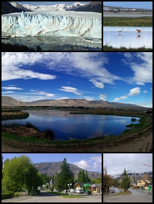
Tourism as the engine of growth
The park's designation as a World Heritage Site (1981), the opening of FTE airport and the rise of nature tourism transformed El Calafate from a ranching town into the main tourist center of southern Patagonia in just a few decades.
Source: https://en.wikipedia.org/wiki/El_Calafate
Signs of change in the glacier
After a long period of apparent balance, since 2019 measurements have shown thinning, mass loss and an accelerated retreat of the Perito Moreno's face: in 2025 the frontal retreat was some 385 meters, the largest on record, and the loss of height at the face went from 0.34 m/year (2000-2019) to 5.5 m/year (2019-2024). Glaciologists are studying whether it will be able to re-anchor at a narrowing of the valley about 700 meters from the current face.
Source: https://www.greenpeace.org/argentina/blog/problemas/climayenergia/alerta-despues-de-anos-de-estabilidad-el-glaciar-perito-moreno-comienza-a-retroceder-a-ritmo-acelerado/
en.wikipedia.org · El Calafateflightradar24.com · FTEes.wikipedia.org · Rompimiento del glaciar Perito Moreno

📚 Bibliography

  • El Calafate Turismo — «Historia de El Calafate»: https://www.elcalafate.tur.ar/historia-de-el-calafate.htm
  • Interpatagonia — «El Calafate: historia y leyendas»: https://www.interpatagonia.com/elcalafate/historia_i.html
  • Wikipedia (EN) — «El Calafate»: https://en.wikipedia.org/wiki/El_Calafate
  • Wikipedia (ES) — «Leyenda de Calafate»: https://es.wikipedia.org/wiki/Leyenda_de_Calafate
  • Wikipedia (EN) — «Berberis microphylla»: https://en.wikipedia.org/wiki/Berberis_microphylla
  • Ladera Sur — «Calafate: de fruto ancestral a superalimento»: https://laderasur.com/articulo/calafate-de-fruto-ancestral-a-superalimento/
  • 19640 Noticias — «Leyenda tehuelche: el que come calafate siempre vuelve»: https://19640noticias.com/contenido/7889/leyenda-tehuelche-el-que-come-calafate-siempre-vuelve
  • Wikipedia (ES) — «Rompimiento del glaciar Perito Moreno»: https://es.wikipedia.org/wiki/Rompimiento_del_glaciar_Perito_Moreno
  • Wikipedia (EN) — «Perito Moreno Glacier»: https://en.wikipedia.org/wiki/Perito_Moreno_Glacier
  • Wikipedia (EN) — «Argentino Lake»: https://en.wikipedia.org/wiki/Argentino_Lake
  • Glaciarium — «Glaciar Perito Moreno»: https://glaciarium.com/es/2022/12/22/glaciar-perito-moreno/
  • Flightradar24 — «El Calafate International Airport (FTE)»: https://www.flightradar24.com/data/airports/FTE
  • Greenpeace Argentina — «El glaciar Perito Moreno comienza a retroceder a ritmo acelerado»: https://www.greenpeace.org/argentina/blog/problemas/climayenergia/alerta-despues-de-anos-de-estabilidad-el-glaciar-perito-moreno-comienza-a-retroceder-a-ritmo-acelerado/

❓ Frequently asked questions

Why does the Perito Moreno Glacier advance and break its own ice bridge?+
The Perito Moreno is fed by the Southern Patagonian Ice Field and advances under the gravitational force of the ice coming down from above. When its face crosses Lake Argentino and touches the Magallanes Peninsula, it forms a natural dam separating the Brazo Rico from the rest of the lake. Water builds up in the arm and rises until it seeps under the ice, opening a tunnel that grows and forms an ice bridge. When that bridge collapses, the water flows again and the levels even out. It's a natural cycle that has repeated many times through the 20th and 21st centuries; the last big rupture witnessed by the public was in March 2018. A caveat: after decades of stability, since 2019 the glacier has entered a phase of accelerated retreat (some 385 meters of frontal retreat in 2025, according to glaciologists), so these ruptures could become rarer and rarer if the face pulls away from the peninsula.
How many days do I need in El Calafate?+
Three full days is the recommended minimum: one for the Perito Moreno walkways, another for a boat trip on Lake Argentino or the mini-trek on the ice, and a third for the town, the Glaciarium and the Laguna Nimez Reserve. If you want to add El Chaltén and the trek to Fitz Roy, set aside 5 to 7 days for the whole region.
When is the best time to visit El Calafate?+
Summer (December to March) has long days and every excursion running, but it's high season, with more people and higher prices. Spring (October-November) and autumn (April, with the forests turning red) are very good options with less tourism. In winter the glacier is still visitable and the snowy landscapes are beautiful, though some services cut their hours; bring good warm clothing whatever the time of year, because the Patagonian weather is changeable.
Is National Park admission included in the excursions?+
Normally not. Most transfers and excursions charge the access fee for Los Glaciares National Park separately: ARS 50,000 for non-resident foreigners, ARS 25,000 for Argentine residents, ARS 15,000 for students and ARS 8,000 for Santa Cruz residents (APN rate table in force since 1 June 2026; source: Argentina.gob.ar/parquesnacionales, verified July 2026). Children under 6, Argentine retirees and people with disabilities don't pay. Ask when you book and check the current amounts on the official National Parks website, since they're updated periodically.
What's the difference between the Mini-trekking and Big Ice?+
Both are walks in crampons on the Perito Moreno run by Hielo y Aventura. The Mini-trekking lasts around an hour and a half on the ice and is suitable for most visitors with basic fitness. Big Ice is much more demanding: close to 4 hours walking, pushing into the heart of the glacier, with fitness requirements and an age limit. If it's your first time on a glacier, the Mini-trekking is usually the better choice.
What does the name 'calafate' mean, and what's the legend about returning?+
The calafate (Berberis microphylla) is a thorny shrub typical of Patagonia, with yellow flowers and small edible dark blue berries. An old Tehuelche legend says that whoever eats its fruit will always return to Patagonia. The town took its name from a large calafate shrub that served as a landmark for the carters, known as 'la mata grande', the big bush.
Can El Calafate be combined with El Chaltén?+
Yes, and it's very common. Both are within the Los Glaciares National Park region and about 215 km of paved road separate them (roughly 3 hours by bus or car). El Calafate is the base for the glacier and the boat trips, and El Chaltén is the national trekking capital, with trails to Cerro Fitz Roy and Laguna de los Tres. Many travelers spend a few days in each.
Sources consulted (29)
Still planning?
Explore more destinations in Argentina
See all destinations →
Advertisements
Image credits
Photos from Wikimedia Commons, each under its own licence (CC BY, CC BY-SA or public domain). Open each file to see its author and licence.
El Calafate Montaje