Viajá con Gus
HomeArgentinaEl Chaltén
El Chaltén
🇦🇷 Argentina · Patagonia

El Chaltén

Jump to what you need
📌Province
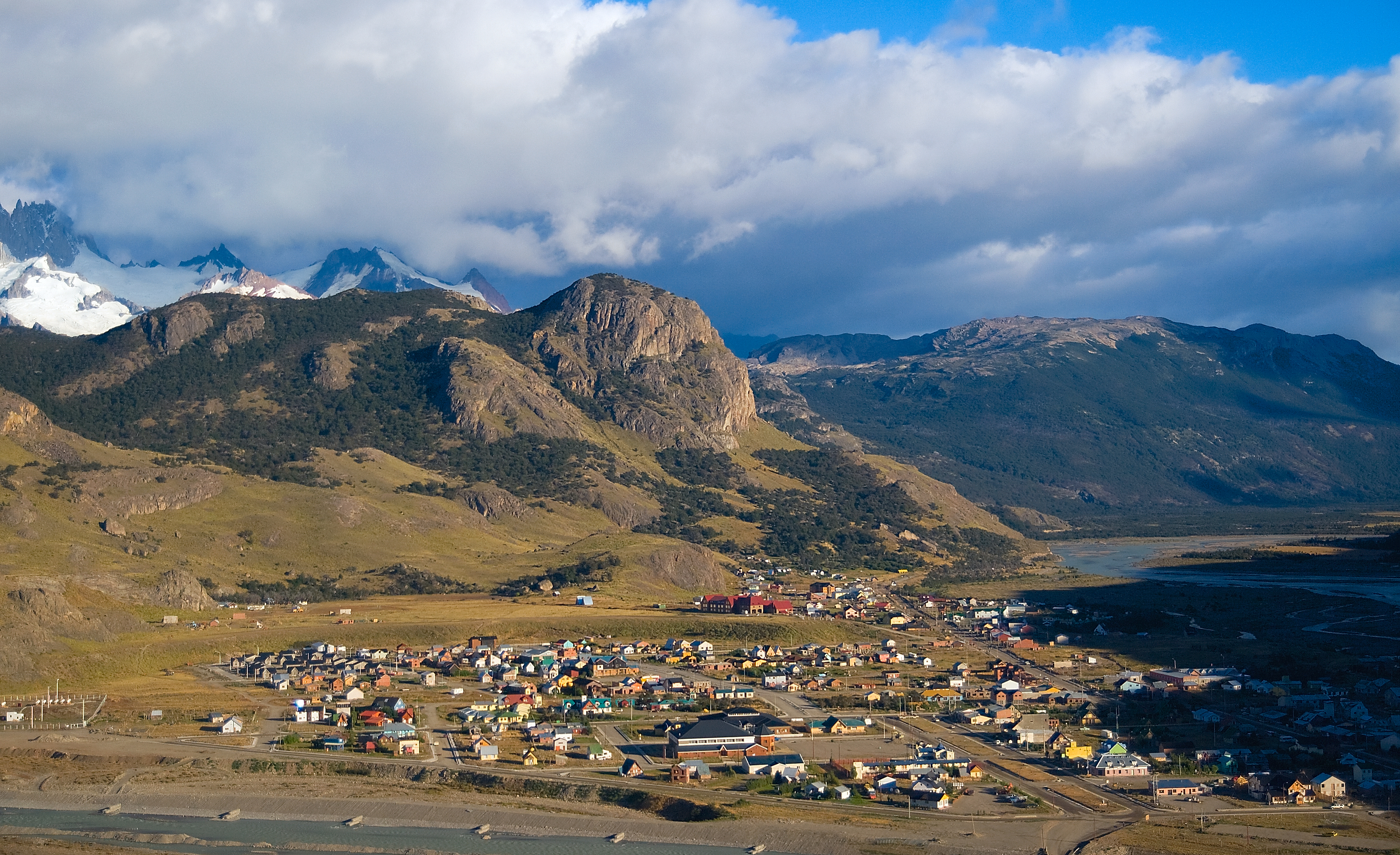
Santa Cruz, at the far south of Argentine Patagonia. El Chaltén sits in the northwest of the province, at the foot of the Fitz Roy massif and inside the northern sector of Los Glaciares National Park, declared a UNESCO World Heritage Site. It's the youngest town in Santa Cruz: it was founded only in 1985, on the bank of the Río de las Vueltas and very close to the Chilean border.
📌Service city
El Calafate is the usual gateway: it has the nearest airport (Comandante Armando Tola, code FTE) and the buses to El Chaltén leave from its terminal, about 215 km away via RN 40 and RP 23. The town of El Chaltén itself is the service base for every trail: it has the National Park office, shops, breweries, hostels and gear rental, though it's small, so bring cash and book ahead in high season.
📌Best time to go
The Patagonian summer, November to March, is the trekking season: long days, open trails and huts running. December, January and February are the busiest months and have the relatively best weather, though strong wind is constant all year. October and April are quieter shoulder months. In winter (June to September) many services close, bus frequency drops and several trails are under snow.
📌Suggested days
A minimum of 2 to 3 nights lets you do the two classics: Laguna de los Tres (Fitz Roy) and Laguna Torre. With 4 or 5 days you can add walks such as Loma del Pliegue Tumbado, the Mirador de los Cóndores, the Chorrillo del Salto and a trip to Lago del Desierto. Leave some slack for the weather: wind and rain can hide the mountains, so having a spare day greatly improves your chances of seeing Fitz Roy clear.
💱 ARS exchange rate
Loading rate…
🌤️ Weather in El Chaltén
Loading weather…

El Chaltén is a mountain town in the heart of Argentine Patagonia, known worldwide as the National Trekking Capital. It sits at the foot of Cerro Fitz Roy and Cerro Torre, two of the most coveted and difficult granite spires on the planet, inside the northern sector of Los Glaciares National Park. Despite its fame, it's still a small place, with gravel streets, little infrastructure and a lot of nature all around.

What makes El Chaltén unique is that its most famous trails start literally from town and are, for the most part, self-guided and open to the public: you can walk to the base of Fitz Roy or Cerro Torre without a compulsory guide or major costs, just with good boots, warm clothes and respect for the weather. That democratized the mountains and turned the town into a magnet for backpackers, climbers and families alike.

The name 'Chaltén' comes from the Indigenous Tehuelche (Aonikenk) languages and is usually translated as 'smoking mountain' or 'mountain that smokes', for the clouds that almost always crown the summit of Fitz Roy and look like smoke. It's also a town with a very recent and very political history: it was born in 1985, almost overnight, in the middle of a border dispute with Chile over the Lago del Desierto area.

📖 History of El Chaltén

El Chaltén is one of the youngest towns in Argentina: it was officially founded on 12 October 1985 by the province of Santa Cruz, largely for geopolitical reasons, to assert Argentine sovereignty in a border area disputed with Chile, that of Lago del Desierto, where in 1965 there had been an armed clash with one man killed. Before that, the place had only a few isolated settlers and ranchers at the foot of Fitz Roy, the mountain that the explorer Francisco P. Moreno had named in 1877 in honor of the sailor Robert FitzRoy, captain of the Beagle. After the 1994 arbitration ruling, which found in Argentina's favor over Lago del Desierto, and the consolidation of Los Glaciares National Park, the town reinvented itself as a world-famous mountain destination and was declared the National Trekking Capital. The full story is on our history page.

Read the full history ↓

🏛️ El Chaltén is in Santa Cruz

The immense province of southern Patagonia: Tehuelche land of the Cueva de las Manos, of the endless steppe and the sheep, of the tragic Patagonia Rebelde, of the glaciers of Perito Moreno and Fitz Roy, with El Calafate and El Chaltén as the gateways to a world of ice.

Read the history of Santa Cruz →

🗺️ What to see

1
Laguna de los Tres and Cerro Fitz Roy
This is El Chaltén's star trek and the best postcard of Fitz Roy. The classic trail starts from town, passes the Río Blanco viewpoints and the Capri and Poincenot campsites, and ends with a brutally steep final stretch of about 400 meters of ascent over loose ground, up to a turquoise glacial lake right at the foot of the spires. It usually runs 20-22 km there and back and 8 to 10 hours; difficulty is medium-high, mainly because of that last kilometer.
Laguna de los Tres is, without argument, the icon of El Chaltén and one of the most famous walks in all of Patagonia. The name honors the three French mountaineers — led by Lionel Terray and Guido Magnone, who summited Fitz Roy in 1952 — and the reward is a turquoise glacial lake that opens up right at the foot of the granite spires: Fitz Roy (3,405 m) in the center, flanked by the Poincenot, Saint-Exupéry and Mermoz spires. When the sky is clear and the walls turn red at dawn, the scene is hard to match anywhere in the world. The great draw is that the trail starts on foot from the town itself, with no need for transport or a guide. It's around 20 to 22 km there and back, with some 750 to 950 meters of cumulative ascent and 8 to 10 hours of walking at an easy pace, with stops for photos and rest. The route is gradual and fairly manageable for most of the way — with viewpoints such as the one over the Río de las Vueltas, the Capri area and the Poincenot campsite — but the last kilometer is another story altogether: a brutally steep climb over loose rock and moraine that gains almost all the height at once and demands legs and patience. You don't need a vehicle to reach the trailhead: the entrance is at the end of Avenida San Martín, at the northern edge of El Chaltén, a few blocks from the center. Anyone wanting to start closer can take a transfer to Hostería El Pilar, on the road to the Río Eléctrico, and climb by a longer but equally beautiful variant. The great majority, though, set off on foot from town very early. The best season is the Patagonian summer, November to March, when long days and snow-free trails give you plenty of daylight. It's worth leaving between 6 and 8 in the morning for two reasons: to beat the crowds on the final stretch and to improve your chances of seeing Fitz Roy clear, since the clouds tend to cover it by mid-morning. Sunrise at the lake, with the spires lit orange, is the biggest prize for the earliest risers. Practically: bring at least 1.5 to 2 liters of water (you can refill from the meltwater streams, they're drinkable), warm layers, a windbreaker, a hat and gloves even in summer, sunscreen and good trekking boots with a firm sole for the last stretch. The Patagonian wind is constant and can be very strong up top, so add a waterproof jacket. Since late 2024 the northern sector of Los Glaciares National Park has charged for access, paid online or by QR code and by card only; check the current rates (they change with inflation) before you set out.
ℹ️ Distance: 20-22 km there and back · Ascent: 750-950 m cumulative · Duration: 8 to 10 hours · Difficulty: Medium-high (the last km is very steep) · Trailhead: End of Av. San Martín, in town
2
Laguna Torre and Cerro Torre
The other great classic, flatter and more accessible than Laguna de los Tres. The path follows the Río Fitz Roy valley to a lake dotted with icebergs at the foot of the Grande glacier, with the unmistakable silhouette of Cerro Torre and its ice 'mushroom' behind. It's around 18-20 km there and back, low-to-medium difficulty, ideal for a first day or for anyone after a more moderate effort.
If Laguna de los Tres is the most famous postcard, Laguna Torre is the other unmissable classic of El Chaltén, and many choose it as their first trek because it's flatter and less demanding. The destination is a glacial lake dotted with icebergs at the foot of the Grande glacier, with the sharp, unmistakable silhouette of Cerro Torre (3,128 m) cut out behind it, crowned by its famous ice 'mushroom', a rime formation that makes it one of the technically hardest peaks on the planet for climbers. The route follows the Río Fitz Roy valley among lenga and ñire forest, with a first gentle climb to the Cerro Torre viewpoint and then a mostly flat and very pleasant path. It's some 18 to 20 km there and back, with close to 250 meters of ascent and 6 to 8 hours of easy walking. Difficulty is low to medium: the main challenge isn't the terrain but the distance and the wind, which on the last exposed stretch in front of the lake can be ferocious. The trailhead is inside town, at the western edge, a few blocks from the center; no vehicle or guide needed. Along the way you pass the De Agostini campsite (also called Bridwell), a historic climbers' base, from which a short climb up the moraine takes you to the edge of the lake and its panoramic viewpoint. The best season, as everywhere in El Chaltén, is November to March. Cerro Torre is even more elusive than Fitz Roy: it spends many days under cloud, so seeing its summit clear is a matter of luck and patience. That's why it's worth having a spare day in your trip and, if the forecast promises a clear morning, using it for this walk. Practically, the same advice applies as for the other trails: water (refillable from streams), warm layers, a sturdy windbreaker, sun protection and comfortable footwear. Being a flat trail with lower physical demands, it's a good option for families with older children or for an acclimatization day. It's also inside the park's northern sector, with paid access via QR code or website (check rates because of inflation).
ℹ️ Distance: 18-20 km there and back · Ascent: ~250 m cumulative · Duration: 6 to 8 hours · Difficulty: Low-medium · Trailhead: Western edge of town
3
Mirador de los Cóndores and Mirador de las Águilas
Two short, very accessible viewpoints reached from the Ceferino Fonzo Visitor Center at the entrance to town. The Cóndores one gives a panoramic view of El Chaltén and the Río de las Vueltas valley; the Águilas one looks out toward Lago Viedma and the steppe. It's a walk of under an hour there and back, perfect for your first sunset or for bad-weather days.
These two viewpoints make the perfect walk for your first day in El Chaltén, for an afternoon when time is short, or for a bad-weather day when the big summits are hidden. They're short, well-signposted trails requiring very little effort, offering a different panorama from the one you get at the lakes: here the star isn't the granite spires but the immensity of the steppe, the valley and Lago Viedma. The Mirador de los Cóndores, about 20-30 minutes of gentle climbing, gives a panoramic view of the whole of El Chaltén from above, with the Río de las Vueltas valley, the Río Fitz Roy and, if the day cooperates, the Fitz Roy massif behind. It's also a good place to watch Andean condors riding the air currents. The Mirador de las Águilas, a little further along the same circuit, looks south, toward the open steppe and the waters of the huge Lago Viedma. Doing both usually takes 1 to 2 hours there and back. The trail starts at the Ceferino Fonzo Visitor Center (the National Park office), at the entrance to town as you come from El Calafate, across the bridge over the Río Fitz Roy. It's a short walk from the center, so no vehicle is needed. It's worth combining the visit with an information talk at the center itself. Being a short, low-difficulty outing, it can be done at any time of day, but it's especially good at dusk, when golden light washes the valley and the clouds tend to open up a little. It's ideal for families, for those who've just arrived and want to stretch their legs, or as a backup plan if wind or rain rules out the long treks. Practically, comfortable shoes, water and a windproof layer are enough: the Patagonian wind hits hard up there. No special preparation needed. It's a good first contact with the landscape and a lovely way to take the town's pulse from above.
4
Loma del Pliegue Tumbado
A more demanding and less-walked route that delivers the best panorama in the area: from the top you see Fitz Roy, Cerro Torre, Laguna Torre and the valleys all at once. It has roughly 1,100 meters of ascent and usually takes 7 to 9 hours there and back; the final stretch is marked with yellow stakes. An enormous reward for anyone after a full day in the mountains.
Loma del Pliegue Tumbado is the connoisseurs' favorite walk and a relatively well-kept secret: less walked than the lakes, but with what is arguably the best panorama in the whole region. From its top, at about 1,500 meters, you see the Fitz Roy range, Cerro Torre, Laguna Torre, the Grande glacier, Lago Viedma and the immensity of the steppe all at once. It's the only walk from which you take in the entire massif in a single sweep, in a 360-degree amphitheater. The route is demanding, above all because of the sustained ascent: some 1,100 meters of climbing over about 20-21 km there and back, taking 7 to 9 hours. It crosses different environments — lenga forest, high steppe and, on the final stretch, a stony plain marked with yellow stakes because the path fades out. There are no technical or dangerous sections, but the climb is relentless and the summit is very exposed to the wind. The trail begins next to the Ceferino Fonzo Visitor Center, at the entrance to town, the same point the Cóndores and Águilas viewpoints start from. No transport or guide required, though given how demanding it is you'll want some fitness and an early start. The best season is summer (November to March), when the top is free of snow and long days give you daylight to spare. Since the reward depends entirely on the weather — there's no shelter up top and the view is everything — this is the trek to save for the best-forecast day of your trip. Under a clear sky, the panorama justifies every step. Practically, it's essential to carry plenty of water (you can refill from streams on the lower section, but there's none up top), serious warm clothing and a windproof, waterproof jacket, because at the summit the wind is very strong and the temperature drops several degrees. Add sun protection, a hat, gloves, energy snacks and firm trekking boots. Set out early enough to get back in daylight. Like the rest of the northern sector trails, access is charged (check rates because of inflation).
ℹ️ Distance: 20-21 km there and back · Ascent: ~1,100 m cumulative · Duration: 7 to 9 hours · Difficulty: High (sustained climb) · Trailhead: Ceferino Fonzo Visitor Center
5
Chorrillo del Salto
A waterfall of about 20 meters very close to town, on the Río de las Vueltas, beside RP 23. The trail is short, almost flat (about 3 km there and back from the end of the street) and you can also get close to the falls by bike or car. Ideal for a quiet afternoon or for days when time is short.
The Chorrillo del Salto is the easiest walk and the closest to town, which is why many choose it as their first contact with El Chaltén's trails or as a backup plan for an afternoon with little time or bad weather. It's a waterfall of about 20 to 25 meters dropping over a rock wall in the middle of lenga forest, fed by the stream of the same name, a tributary of the Río de las Vueltas. It doesn't have the drama of the big lakes, but the spot is cool, shaded and very photogenic, with the water tumbling through the green. The route crosses a pleasant low hillside forest and ends at the foot of the falls, where you can go up to the base and feel the spray. It's a low-effort outing, with no technical sections or significant climbing, suitable for children, families and older visitors. Its main appeal is how accessible it is and how quickly it's done. There are two ways to get there. On foot, the path starts at the end of Avenida San Martín, at the same trailhead as Laguna de los Tres, but taking the right-hand branch; it's about 3 km one way (around 6-7 km there and back if you walk the whole thing) and about 45 minutes each way. The other option is to go by bike or car along RP 23 to a small parking area beside the road and, from there, walk barely 15 minutes to the waterfall. It can be done at any time of year and any time of day, though being in the forest it looks best in even light and without too much wind. It's ideal for stretching your legs on arrival day, for a short mid-afternoon outing or for combining with a bike ride through the Río de las Vueltas valley. Practically it needs almost nothing: comfortable shoes, water and a windproof layer are enough. Being so accessible it tends to get busy in high season, so to enjoy it more peacefully go early or near dusk. It's in the park access sector, so it's worth asking at the National Park office whether at that moment it falls inside or outside the trail charge (check current rates because of inflation).
ℹ️ Distance: ~6-7 km there and back on foot (or 15 min from the parking area) · Ascent: Almost none · Duration: 1 h 30 to 2 h there and back · Difficulty: Low · Trailhead: End of Av. San Martín (right-hand branch) or the parking area on RP 23
6
Fitz Roy viewpoint (on RP 23)
A panoramic viewpoint on the access road, before reaching town coming from El Calafate, where you get your first sight of the Fitz Roy massif cut out above the valley. It's a classic stop for buses and cars to take the welcome photo; no walking required.
The Fitz Roy viewpoint on RP 23 is El Chaltén's welcome postcard: the place where, coming from El Calafate along the road, the whole massif first appears cut out on the horizon. After kilometers of monotonous steppe, the range opens up all at once with Fitz Roy in the center, flanked by Cerro Torre, the Poincenot spire and company, and below it the Río de las Vueltas valley and the town peeking out among the mountains. It's one of those panoramas that makes everyone stop. It's not a trail and requires no walking: it's a panoramic point at the roadside, with space to park, where the scheduled buses usually stop for a few minutes so passengers can take the photo and where private cars pull over without trouble. From the viewpoint you take in at a glance the whole range you'll be walking through over the following days, which makes it a lovely introduction to the destination. It's on RP 23, on the final approach before crossing the bridge over the Río Fitz Roy and entering town. Anyone arriving by bus gets it as part of the journey; anyone driving just needs to watch for the signs and the widening of the road. There are usually welcome signs in the area too, plus smaller viewpoints toward the Viedma glacier and Lago Viedma. The best moment is, simply, whenever the sky is clear: as everywhere in El Chaltén, Fitz Roy is covered by cloud very often, so if it's visible when you arrive, take the photo, because it can disappear in minutes. Afternoon light, warmer and low-angled, usually flatters the shot. Practically, all you need is to wrap up when you get out of the vehicle — the wind hits hard and sideways — and to have your camera or phone handy. It's a stop of a few minutes, free and on the way, meant more to mark your arrival than to linger: the real show starts afterwards, walking out from town.
7
Lago del Desierto
A long, deep lake about 37 km north of town, surrounded by Andean-Patagonian forest, with a view of Fitz Roy from the water. It was the heart of the border dispute with Chile that prompted the founding of El Chaltén. You can walk its shore, take a catamaran to the northern end and, from there, connect with crossings into Chile (Villa O'Higgins). The access road (RP 23) is gravel and follows the Río de las Vueltas.
Lago del Desierto is El Chaltén's great full-day excursion that doesn't involve a long trek, and one of the most beautiful: a long, narrow lake — some 12 km long by 2 wide — hemmed in between mountains and ringed by dense Andean-Patagonian forest that reaches down to the shore. From the water, looking south, the north face of Fitz Roy stands out, a different perspective on the mountain from the classic one seen from town. Beyond the scenery, the lake carries enormous historical weight: it was the heart of the border dispute with Chile that in 1965 left one man dead and that ultimately prompted the founding of El Chaltén in 1985; only the 1994 arbitration ruling settled it definitively in Argentina's favor. There are several ways to enjoy it. The most popular is to combine the catamaran crossing from shore to shore — around an hour heading to the northern end, where the Gendarmerie post is — with short walks: from the north pier you can climb to the Cono/Centinela viewpoint to see the lake end to end with Fitz Roy behind, or walk to the Huemul glacier and its small iceberg-dotted lagoon. You can also cover part of the southern shore on foot, without a boat, on trails through the forest. From the northern end, too, the famous international crossing to Villa O'Higgins (Chile) begins, combining barges, boats and walking, in summer only. To get there you cover some 37 km north of town on RP 23, a gravel road that follows the canyon of the Río de las Vueltas between forests and viewpoints; the trip by car or shuttle takes around 1 to 1.5 hours given the state of the road. You don't need your own vehicle: there are regular transfer and shuttle services leaving from town, and many agencies sell the excursion combined with the boat trip. Book ahead, especially in high season. The best season is summer (November to March), when the boats and crossing services are running and the long days give you room to combine transport, boat and walking in a single day. It's an ideal outing for a day when the forecast doesn't suit the big treks, or simply to vary the scenery and rest your legs. Practically, allow a full day and bring a packed lunch, water, warm layers and a windproof jacket, because on the water and at the pier it's cold even in sunshine. Access to the Lago del Desierto area is usually handled with a fee or ticket separate from the National Park, and the catamaran is paid separately; ask and book ahead (check current rates because of inflation). Bring cash just in case, since there's no connectivity in the area.
ℹ️ Distance from town: ~37 km north on RP 23 (gravel) · Access: Car, shuttle or transfer; ~1 to 1 h 30 of travel · Lake dimensions: ~12 km long by 2 wide · Excursion duration: Full day (with the boat trip and walks) · Difficulty: Low (the walks around it are short)
8
Río de las Vueltas and the access valley
The river that shapes the valley El Chaltén sits in, glacier-colored, follows almost the entire road between town and Lago del Desierto. It's a landscape of steppe, lenga and ñire forest and mountain viewpoints; ideal to cover by car or bike, stopping at the Chorrillo del Salto and in the Río Eléctrico area.
The Río de las Vueltas is the river that shapes the valley El Chaltén sits in and, more than a single attraction, it's a scenic route enjoyed on the way to Lago del Desierto. Glacial gray and winding — hence its name, 'river of the bends' — it comes down from the north and follows almost the whole of RP 23 between town and the lake. The landscape shifts from lenga and ñire forest to open steppe, with mountain viewpoints, rock walls, and the silhouette of Fitz Roy appearing and disappearing with the clouds. The nice thing about this valley is that it lines up several stops along one axis and you can put it together as you like: the Chorrillo del Salto a few kilometers from town, the viewpoints over the river canyon, the turnoff to the Río Eléctrico gate (Piedra del Fraile) and, at the end, Lago del Desierto. It's a route to take slowly, stopping wherever the scenery invites, rather than a destination with a single end point. The usual way to cover it is by private or rental car, or by bike for the sections closest to town, since RP 23 is gravel and follows the river practically the whole way. For cycling, bear in mind the Patagonian wind, which can be very strong and head-on, and the state of the gravel. You can also combine it with the transfer to Lago del Desierto, which takes the same road. The best season is summer (November to March), when the road is in better condition, the days are long and transport services run regularly. In the shoulder seasons the autumn forest (April) gives very photogenic reds and golds, though services run less often. Practically, if you're driving, fill up in El Calafate or in town before setting out, bring water and food, and drive carefully on the loose gravel. On a bike, add a windproof layer, plenty of water and allow extra time for the wind. There are no services along the way, so leave El Chaltén with everything you need sorted.
ℹ️ Route: RP 23 between town and Lago del Desierto (~37 km, gravel) · Suggested stops: Chorrillo del Salto, the canyon viewpoints, the Río Eléctrico gate · How to do it: Car, bike (nearby sections) or transfer · Difficulty: Low (scenic; medium by bike because of wind and gravel)
9
Piedra del Fraile and Río Eléctrico
A valley further north, entered via the Río Eléctrico gate, about 16 km from town. From there trails run to Piedra del Fraile, the Piedras Blancas lagoons and the north face of Fitz Roy, as well as multi-day routes to the Marconi glacier and the ice field. It's the favorite area of climbers and long-distance trekkers.
The Río Eléctrico valley, with Piedra del Fraile as its star destination, is the northernmost part of the sector and the favorite of climbers and long-distance trekkers looking for less crowded corners. The walk climbs along the bank of the turquoise Río Eléctrico, through beautiful lenga forest, to the Piedra del Fraile hut, set beside the river at the foot of Fitz Roy's north face. It's a wilder, more intimate setting than the classic trails, with granite walls, hanging glaciers and far fewer people. The main trail is a little under 8 km one way (close to 15-16 km there and back) with moderate ascent, about 2 hours of climbing and low to medium difficulty: what's demanding isn't the gradient but the distance and the wind. At the Piedra del Fraile hut there's camping, dormitory beds and a small food service; ten minutes away is the natural Piedra del Fraile viewpoint, a short steep climb with a view over the valley. Several more objectives open up from the area: the Pollone glacier, the Piedras Blancas lagoon, and to the west the multi-day crossings to the Marconi glacier, the Paso del Viento and the Patagonian ice field, which is mountaineers' terrain. Access is via the Río Eléctrico gate, on the road north of town, about 16-17 km from El Chaltén; the trailhead is next to the red bridge over the Río Eléctrico. You don't need a vehicle: there are regular shuttle and transfer services that drop you at the gate and come back at agreed times; you can also drive in by private car along the gravel RP 23. The best season is summer (November to March), when the trail is clear of snow, the huts are running and transport is frequent. Given its profile, it's ideal for anyone who has already done the classics and wants a different, quieter day, or as a base for longer crossings toward the ice field (those do require a guide and experience). Practically, bring water (refillable from the river and streams), warm layers, a windproof and waterproof jacket, sun protection and food. If you plan to stay overnight at the hut or campsite, book ahead in high season. This area falls within the park's northern sector, with paid access via QR code or website at the gate, by card only (check current rates because of inflation).
ℹ️ Distance: ~15-16 km there and back to the hut · Ascent: Moderate · Duration: ~2 h of climbing; 5 to 7 h there and back · Difficulty: Low-medium · Trailhead: Río Eléctrico gate, ~16-17 km north of town
10
The Visitor Center and the National Park trails
The Los Glaciares National Park office (the Ceferino Fonzo information center) is an essential stop on arrival: they give introductory talks, maps, trail conditions and the safety and forest protection rules. Go on your first day to plan your walks and check the forecast, since the weather changes very fast.
The Ceferino Fonzo Visitor Center is the Los Glaciares National Park office in El Chaltén and the first recommended stop on reaching town, before tackling any walk. It's much more than an information point: the rangers give a short introductory talk on the park's northern sector, hand out maps, report the condition and status of each trail, the state of the campsites and, above all, the safety rules and the rules protecting the forest and wildlife. In a destination where the weather changes in minutes, coming here on your first day is the best way to plan your trip properly. Beyond its information role, the center works as a trail hub: walks such as the Mirador de los Cóndores and Mirador de las Águilas and the demanding Loma del Pliegue Tumbado start from just outside it, so it's a key reference point within town. There are usually interpretive panels on the geology, flora and history of the area, including the formation of the Fitz Roy massif and the Lago del Desierto border dispute. It's at the entrance to town coming from El Calafate, across the bridge over the Río Fitz Roy, a short walk from the center: no vehicle needed. Anyone arriving by bus passes it almost on the way, and the visit can be combined with the climb to the nearby viewpoints. The ideal is to go on your first day, as soon as you arrive, to build your walking plan around the forecast — worth checking daily, because it determines which trek to do each day — and to clear up any questions about paid park access. Having the distances, times and trail conditions clear before you set out avoids nasty surprises and walks ruined by bad weather. Practically, entry to the center and the talks are free. It's a good moment to ask about the northern sector's trail charging system — paid online or by QR code, by card only — and to check the current rates, which change with inflation. It's also the place to find out about the rules for free camping, waste handling (everything you carry in, you carry out) and the fire ban, all key to looking after this ecosystem.
Advertisements
What nobody tells you

💵 Prices

Tickets

TypePrice
Northern Zone trails of Los Glaciares NP (Laguna de los Tres, Laguna Torre, Pliegue Tumbado, Cóndores, etc.)Paid access per day: foreigners AR$ 50,000 (~US$ 47), Argentine residents AR$ 25,000, students AR$ 15,000, Santa Cruz residents AR$ 8,000 (source: National Parks Administration, rates in force since 1 June 2026, verified July 2026). There are 3-day and 7-day Flexipasses and an annual pass (exact amounts only on the sales portal). Exempt from payment: retirees, children aged 0 to 5, people with disabilities, local residents and Malvinas veterans. Payment is only online or by QR code at the gates (Los Cóndores, Base Fitz Roy, Río Eléctrico), by card only, no cash (source: argentina.gob.ar/interior/ambiente/parquesnacionales/losglaciares/tarifas, verified July 2026).
Ceferino Fonzo Visitor Center (talks and information)Free (source: National Parks Administration, verified July 2026)
Fitz Roy viewpoint on RP 23 and Chorrillo del Salto (access sector)Free; the Chorrillo del Salto lies outside the paid gates of the Northern Zone (source: trekkingelchalten.com/cobro-de-acceso-a-los-senderos, verified July 2026)
Lago del Desierto (access via RP 23) and the catamaran tripAccess to the Lago del Desierto area is handled separately from the National Park. The catamaran trip to Punta Norte/the Vespignani reserve costs AR$ 16,000 (~US$ 12), paid in cash on the day at the pier; the crossing takes about 45-50 min (source: howlanders.com and local boat operators, verified July 2026).
🔄 updated monthlyOfficial / reference values · double-check when buying

Activities and tours

ActivityPriceDurationOperator
Self-guided trek to Laguna de los Tres (Fitz Roy)Public-use trail; you only pay for access to the park's Northern Zone (foreigners AR$ 50,000 / ~US$ 47 per day; source: APN, verified July 2026). Optional guides US$ 60–120 per person (range based on local trekking agencies in El Chaltén, verified July 2026)8 to 10 hours, a full daySelf-guided; optional local guides and agencies available
Self-guided trek to Laguna TorrePublic-use trail; only access to the park's Northern Zone (AR$ 50,000 / ~US$ 47 for foreigners per day; source: APN, verified July 2026). Optional guides US$ 50–100 per person (range based on local agencies, verified July 2026)6 to 8 hoursSelf-guided; optional guides
Guided treks and multi-day crossings (ice field, Paso del Viento, Huemul)US$ 150–250 per day per person on guided crossings with gear; 3-4 day circuits US$ 500–900 (range based on El Chaltén mountain agencies such as Fitz Roy Expediciones and Patagonia Aventura, verified July 2026)1 to 4 days depending on the circuitLicensed El Chaltén mountain agencies and guides
Ice climbing and glacier trekking (Viedma glacier / ice field sector)US$ 180–350 per person, full day with gear and guide (range based on El Chaltén glacier and mountaineering operators, verified July 2026)Full dayLicensed glacier and mountaineering operators
Catamaran trip on Lago del DesiertoBoat trip AR$ 16,000 (~US$ 12), paid in cash on the day of the excursion (source: howlanders.com and local operators, verified July 2026); full-day excursion with transfer from El Chaltén US$ 60–110 per person (range based on agencies such as Patagoniachic and Zona Austral Turismo, verified July 2026)About 50 min on the water, half day to full day including transfersExploradores Lago del Desierto and other operators
Horseback rides through the valleys and estancias of the areaUS$ 40–90 per person, half day to full day (range based on El Chaltén horseback riding agencies, verified July 2026)Half day to full dayLocal riding outfits and estancias
Mountain biking on RP 23 (Chorrillo del Salto, Río de las Vueltas valley)Bike rental US$ 15–30 a day (range based on rental shops in town, verified July 2026)Half dayBike rental shops in town
Fly fishing (rivers and Lago del Desierto)Guided outing US$ 150–350 per person; requires a Santa Cruz fishing permit, about US$ 30 a day for foreigners (range based on local fishing guides and the Santa Cruz Agrarian Council, verified July 2026)Half day to full dayLicensed fishing guides
🔄 updated monthlyOfficial / reference values · double-check when buying
Advertisements

🚌 How to get there and distances

Getting around

ModePriceDurationNotes
On footFree (verified July 2026)You can cross the town on foot in 15-20 minutesEl Chaltén is very compact and most trails start from the town itself or very close by; walking is the natural way to get around.
Transfer / shuttle to the trail gates (Río Eléctrico, Lago del Desierto)US$ 15–40 round trip depending on the destination (range based on El Chaltén transfers and local agencies, verified July 2026)20 to 60 minutes depending on the destinationRegular shuttle services run to the more distant trailheads, such as Río Eléctrico (Piedra del Fraile) and Lago del Desierto; book ahead.
Bicycle (rental)US$ 15–30 a day; by the hour from US$ 4–6 (range based on rental shops in town, verified July 2026)By the hour or by the dayUseful for the Chorrillo del Salto and for riding RP 23; bear in mind the strong wind and the gravel.
Private or rental carRental US$ 50–90 a day plus fuel (range based on rental agencies in El Calafate and El Chaltén, verified July 2026)VariesThere's a service station in town, but it's better to fill up in El Calafate. The roads to Lago del Desierto and Río Eléctrico are gravel.
Local taxi / remísShort trips US$ 5–15 (range based on local remís firms, verified July 2026)Short tripsLimited availability; useful for getting to trailheads or the bus terminal.
🔄 updated monthlyOfficial / reference values · double-check when buying

How to get there

RouteAirlines / operatorsAvg. priceDuration
El Calafate (bus terminal and FTE airport) → El Chaltén by bus via RN 40 and RP 23TAQSA, Chaltén Travel, Cal-Tur, Lengas, among othersAR$ 50,000 (~US$ 47) each way, plus a municipal fee of AR$ 2,000 (source: elchalten.com/v4/es/transporte-buses-en-el-chalten.php, verified July 2026)About 3 hours (between 2 h 40 and 3 h depending on the service); some 215 km
El Calafate airport (Comandante Armando Tola, FTE) → El ChalténThe buses leaving El Calafate's terminal stop at the airport to pick up passengers; Lengas offers a door-to-door transfer; there are private transfers tooBus AR$ 50,000 (~US$ 47) each way; private transfer US$ 200–350 per vehicle (range based on El Calafate transfer agencies, verified July 2026)About 3 hours from the airport
Buenos Aires → El Calafate (FTE) by plane, then bus to El ChalténAerolíneas Argentinas, JetSMART, Flybondi to El Calafate; then bus or transferFlight US$ 90–250 one way (range depending on the airline and how far ahead you book, verified July 2026) + bus AR$ 50,000 (~US$ 47)A flight of about 3 h 15 to El Calafate + 3 h by bus
International crossing from Villa O'Higgins (Chile) via Lago del DesiertoA combination of barges, boats and walking/transport (seasonal services)US$ 80–150 per person for the full crossing, boats plus transport (range based on local operators and traveler forums documenting the route, verified July 2026)A full-day crossing, summer season only and weather permitting
🔄 updated monthlyOfficial / reference values · double-check when buying

🏨 Where to stay

No exact prices: a scale from $ (budget) to $$$$$ (luxury), with 2-3 options per category.

CategoryPriceRecommended options
Boutique and upper-category hotels$$$$$US$ 180–400+ a night (range based on Booking.com and Expedia for boutique hotels and mountain lodges, verified July 2026). Fitz Roy views and higher-comfort services, on the slopes above town. The upmarket offering is limited by the size of the town; book well ahead in high season.
Mid-range hotels and inns$$$$$US$ 80–170 a night (range based on Booking.com and Expedia, verified July 2026). Most of the accommodation is mid-range inns, cabins and family hotels, many along Av. San Martín and Av. Lago del Desierto, with breakfast and good access to the trails. The most common choice for couples and families.
Bed & breakfasts, cabins and apart-hotels$$$$$US$ 60–130 a night (range based on Booking.com and Airbnb, verified July 2026). B&Bs, apartments and short-term rental cabins abound, ideal for those staying several days who want to cook. Many are steps from the trailheads.
Hostels and bunkhouses$$$$$US$ 15–35 per person in a shared dorm; private rooms from US$ 50 (range based on Hostelworld and Booking.com, verified July 2026). A strong hostel scene with shared kitchens and a traveler atmosphere; the classic base for trekkers and climbers on a tight budget.
Camping and mountain huts$$$$$Organized camping in town US$ 8–15 per person (range from local campsites and trekking blogs, consulted in July 2026). The free campsites inside Los Glaciares National Park (Poincenot, De Agostini/Laguna Torre) are free to use and have no services: you must carry out all your rubbish and respect the ban on campfires. In the Río Eléctrico sector is the Piedra del Fraile hut, one of the oldest in the area, run by Refugios de Patagonia (refugiosdepatagonia.com, reservas@refugiosdepatagonia.com). Details published by the operator itself: it can only be reached on foot, from the Río Eléctrico bridge — 16 km from town via RP 41, with regular transport from El Chaltén — along a low-difficulty trail of about 2 hours. It offers camping, two shared rooms for four people and one for six, shared bathrooms and a café, and serves as a base for Piedra Negra, Paso del Cuadrado, Lago Eléctrico and Laguna Pollone. Availability is checked by WhatsApp. It publishes no rates on its website (no rate published on the establishment'S WEBSITE, verified August 2026) and the «Reservá acá» button on the Piedra del Fraile page leads by mistake to the booking engine of another hut run by the same operator, Puesto Cagliero, so confirm by WhatsApp before taking anything as booked.
Specific establishments (verified names)$$$$$The El Chaltén Tourism Secretariat publishes its register by category at https://elchalten.tur.ar/category/alojamiento/. Hotels: Lunajuim (https://lunajuim.com), Los Cerros Boutique Hotel, Destino Sur, Chaltén Suites, Cumbres Nevadas, Desierto Suites, Explora, De Los Tres, Lago del Desierto and Las Piedras. Inns: El Puma, El Barranco, Nunataks, Alma Patagonia, Confín Patagónico, El Álamo, Don Galle, San Antonio, Magna B&B and Don't Atilio. The register also has sections for hostels, apart-hotels and cabins, estancias and camping. WARNING: destinosur.com, the domain associated with Hotel Destino Sur, is today FOR SALE on GoDaddy (verified in a browser on 08/08/2026): the hotel appears in the municipal register, but that domain is no longer its website.

🍴 Where to eat

TypePriceOptions / signature dish
Craft breweries and gastropubs$$$$$US$ 12–25 per person, pint US$ 4–7 (range from TripAdvisor and traveler blogs, consulted in July 2026). El Chaltén is famous for its craft breweries, serving pizzas, pasta, salads and stews: the classic post-trek ritual. The reference point is La Cervecería Chaltén, at Av. San Martín 320 (IG @lacerveceriachalten, tel. +54 9 2962 493109, lacerveceria.chalten@gmail.com): a brewpub that has brewed its own beer on site since 1999 — pilsner, bock, amber lager and wheat beer — and which in August 2026 was still advertising on its own profile hours of 12:30pm to midnight, every day. It publishes no menu with prices on any of its own channels. The most popular places fill up fast after sunset.
Grills and Patagonian cooking$$$$$US$ 18–40 per person (range from TripAdvisor and Google Reviews, consulted in July 2026). Restaurants serving Patagonian meats, lamb, stews and generous plates to refuel on. One case with its own published menu and prices: La Vinería Grill, at Andreas Madsen 71 (elchalten.com/lavineriagrill, reservations by WhatsApp on 02966 15 44-8001), a meat house that grills its cuts over red quebracho wood and also does pasta and vegetarian options. It opens evenings only, from 6pm to 11:30pm, and takes direct reservations. Prices from its own menu (August 2026, in Argentine pesos): beef, lamb, guanaco or quinoa empanadas and blood-sausage bites $6,000; soup of the day, bruschetta and vegetable skewers $12,000; guanaco carpaccio, smoked trout or dry-aged ribeye $20,000; sweetbreads and provoleta $22,000; prawn skewers $25,000; sides $13,000–20,000; pasta $25,000–58,000; grilled mains $34,500–63,500; dry-aged meats $58,500–77,000. Salads $15,000–20,000. Watch out for the name: guides use «La Vinería», «La Vinería Grill» and «La Viñeria Grill & Pasta» interchangeably; the venue's own website uses La Vinería Grill.
Wine bars and contemporary cooking$$$$$US$ 25–55 per person (range from TripAdvisor and food blogs, consulted in July 2026). Wine bars and more refined kitchens, with sharing boards, reworked regional dishes and a good wine selection, ideal for a quiet end to the day. The largest wine list any establishment in town claims on its own website is that of La Vinería Grill (Andreas Madsen 71): a cellar with more than 100 labels from Argentina's main wine regions, with bilingual staff and views of the Fitz Roy range (verified on its website, August 2026).
Cafés, bakeries and chocolate shops$$$$$US$ 5–15 per person (range based on TripAdvisor, verified July 2026). Specialty coffee shops, bakeries and chocolate shops that open early, perfect for a big breakfast before walking or for buying trail food.
Takeaway delis, pizzerias and budget options$$$$$US$ 6–15 per person (range based on TripAdvisor and backpacker forums, verified July 2026). Takeaway delis, pizzerias and food to go that sort out quick, cheap dinners, much used by those staying in hostels or cooking little; there are vegetarian options too.
Specific venues (verified names)$$$$$From the same register, food section. Grills: La Vinería Grill, El Muro, Parrilla Oveja Negra, Butch, Paso del Torre and The Asadores. Breweries and bars: La Zorra, La Birre, Andreas, Espacio Soda, Bourbon Smokehouse, Don Guerra, Fresco Bar, Nómade and Burger Fitz. The register also has tea houses, chocolate shops, bakeries, ice cream parlors and vegetarian kitchens, which matter in El Chaltén because on many days you head out walking with a packed lunch. no menu published on the establishment'S WEBSITE.
Advertisements

📖 History of El Chaltén

Origins, formation and what the sources say.

The Tehuelche and the name Chaltén: the mountain that smokes

There's a mountain in Patagonia that seems to be permanently on fire: its summit gives off 'smoke' 365 days a year. It isn't a volcano — it's pure granite — but the Tehuelche, who revered it, called it Chaltén, 'the mountain that smokes', deceived by the clouds the wind hangs eternally from its peak. Long before the town existed, the valley at the foot of Fitz Roy and Cerro Torre was the territory of those Indigenous peoples of southern Patagonia, the Aónikenk or southern Tehuelche, hunter-gatherers who moved across the steppe and the forests following the guanaco and the rhea. For them, the great granite spire that dominates the landscape wasn't 'Fitz Roy' but 'Chaltén'.

The word 'Chaltén' comes from the Aonikenk (Tehuelche) language and is usually translated as 'mountain that smokes' or 'smoking mountain'. The name describes a very concrete, everyday phenomenon: the summit is almost always wrapped in a lenticular cloud or in shreds of cloud dragged along by the Patagonian wind, giving the impression that the mountain is permanently giving off smoke.

Deeper interpretations grew out of that phenomenon too. In some Indigenous accounts, the Chaltén was a sacred mountain, a volcano or the dwelling place of forces and deities, and the 'smoke' from its summit had a spiritual meaning, not just a meteorological one. When the new town needed a name in 1985, 'El Chaltén' was chosen precisely to recover the mountain's Indigenous place name over the European name of the peak.

'Mountain that smokes', because of the clouds
The most widespread and accepted interpretation is that 'Chaltén' means 'mountain that smokes' or 'smoking' in the Tehuelche/Aonikenk language, referring to the clouds that almost always crown the summit of Fitz Roy and that, dragged along by the wind, look like smoke or steam coming off the mountain.
Source: https://es.wikipedia.org/wiki/Monte_Fitz_Roy
The sacred mountain, or the 'volcano'
There's an idea that the Indigenous peoples considered the Chaltén a sacred mountain and that some accounts associated it with a volcano, precisely because of that smoking-summit appearance. Whatever the geological facts (it isn't an active volcano), it reflects the reverence the mountain held for the original inhabitants.
Source: https://www.elchalten.gob.ar/el-chalten/
es.wikipedia.org · Monte Fitz Royelchalten.gob.ar · El chaltenen.wikipedia.org · El Chaltén

The explorers and the naming of Fitz Roy (1877)

Through the 19th century, southern Patagonia was crossed by scientific and exploratory expeditions that gradually attached European names to the geography. In 1877, the Argentine explorer and naturalist Francisco Pascasio Moreno, the famous 'Perito Moreno', during his travels along the Santa Cruz river and through the Andean region, gave the imposing Cerro Chaltén the name 'Fitz Roy'.

The tribute was to Robert FitzRoy, the British sailor who had commanded HMS Beagle on its second voyage, the one that carried Charles Darwin. FitzRoy had explored the Fuegian channels and traveled part of the way up the Santa Cruz river in the 1830s, so Moreno thought it fitting to attach his name to the most imposing mountain in the area. Over the years the peak came to be known internationally as Fitz Roy, while the original name 'Chaltén' remained as the local term and later gave the town its name.

That border region took a long time to be settled. After the 1881 boundary treaty between Argentina and Chile, the actual demarcation in the Andes was left to surveyors from both countries, among them Francisco Moreno himself for Argentina and Diego Barros Arana for Chile, toward the end of the 1890s. Cerro Chaltén/Fitz Roy, at some 3,405 meters, ended up serving as a binational boundary marker, but the area immediately to the north, that of Lago del Desierto, would remain unresolved for almost the whole of the 20th century.

Why it's called 'Fitz Roy'
The name was given by the explorer Francisco P. Moreno in 1877 in tribute to Robert FitzRoy, captain of HMS Beagle, the ship that explored the channels of Tierra del Fuego and the Santa Cruz river and that carried Charles Darwin on his famous voyage. That's why, although the mountain already had a Tehuelche name ('Chaltén'), it came to be known worldwide as Fitz Roy.
Source: https://es.wikipedia.org/wiki/Monte_Fitz_Roy
Chaltén or Fitz Roy: two names side by side
Today both names coexist: the cartographic, international 'Fitz Roy' and the original 'Chaltén', claimed as the mountain's historic name and adopted by the town in 1985. In practice they're used interchangeably, though some prefer 'Chaltén' for its Tehuelche root.
Source: https://en.wikipedia.org/wiki/El_Chalt%C3%A9n
es.wikipedia.org · Monte Fitz Royen.wikipedia.org · El Chalténelchalten.com · Resenia historia el chalten

The border conflict with Chile and the hurried founding of 1985

El Chaltén wasn't born out of tourism but out of geopolitics. For much of the 20th century, the Lago del Desierto area, a long lake north of Fitz Roy, was disputed between Argentina and Chile, because the boundary treaty had not clearly resolved where the border ran between Lake O'Higgins/San Martín and the Fitz Roy massif.

Tension escalated dramatically on 6 November 1965, when an armed clash between Argentine gendarmes and Chilean carabineros in the Lago del Desierto area ended with the death of the Chilean lieutenant Hernán Merino Correa and several carabineros detained. The so-called 'Lago del Desierto incident' left a deep diplomatic wound and reinforced, on the Argentine side, the conviction that sovereignty had to be asserted with a permanent civilian presence on that still-undefined border.

In that context, on 12 October 1985, the province of Santa Cruz officially founded El Chaltén, almost from nothing and in a hurry, largely to 'plant the flag' and consolidate effective occupation of the disputed territory. The town started with very few inhabitants, no services and in extremely harsh conditions. Years later the conflict was resolved peacefully: on 21 October 1994 an international arbitration tribunal ruled in favor of the Argentine position over the disputed Lago del Desierto area (some 481 km²), and in 1995 it dismissed Chile's appeals. So the town founded for reasons of sovereignty ended up definitively in Argentine territory.

A founding for the sake of sovereignty
The most accepted historical account is that El Chaltén was founded on 12 October 1985 by the province of Santa Cruz mainly for geopolitical reasons: to establish a permanent civilian population in a border area disputed with Chile (Lago del Desierto) in order to strengthen Argentina's position ahead of the arbitration. Tourism came much later.
Source: https://en.wikipedia.org/wiki/El_Chalt%C3%A9n
The 1965 incident as the key precedent
The clash of 6 November 1965 at Lago del Desierto, with the death of the Chilean lieutenant Hernán Merino, is pointed to as the episode that crystallized the dispute and sharpened Argentina's urgency to occupy the area, which helps explain the 'hurried' founding of the town two decades later.
Source: https://es.wikipedia.org/wiki/Disputa_de_la_laguna_del_Desierto
The 1994 ruling: a peaceful close
The dispute was finally settled by international arbitration: on 21 October 1994 the tribunal ruled by majority in Argentina's favor over the Lago del Desierto area, and in 1995 it rejected Chile's appeals for review and interpretation. That's the outcome that consolidated Argentine sovereignty over the territory where El Chaltén had been born.
Source: https://es.wikipedia.org/wiki/Disputa_de_la_laguna_del_Desierto
es.wikipedia.org · Disputa de la laguna del Desiertoen.wikipedia.org · Laguna del Desierto incidenten.wikipedia.org · El Chalténelchalten.gob.ar · El chalten

The northern Los Glaciares National Park and the epic of climbing

El Chaltén lies in the northern sector of Los Glaciares National Park, created in 1937 and declared a UNESCO World Heritage Site in 1981. While the park's southern sector is famous for the Perito Moreno glacier (near El Calafate), the northern sector is the realm of high mountains: the granite spires of Fitz Roy and Cerro Torre, the Southern Patagonian Ice Field and a handful of glaciers, lakes and valleys that made the area a sanctuary of world mountaineering.

Cerro Torre, in particular, is at the center of one of climbing's most contested stories. In 1959, the Italian Cesare Maestri, together with the Austrian Toni Egger and his compatriot Cesarino Fava, attempted the east face; Egger was swept away and killed by an avalanche on the descent and Maestri claimed to have reached the summit, though the only proof reportedly disappeared with Egger's camera. The climbing community never fully accepted that ascent. In 1970, Maestri returned and equipped the rock using a gas-powered compressor to place hundreds of bolts, the famous and disputed 'compressor route', which didn't convince either, because the anchors stopped short of the summit. The first undisputed ascent of Cerro Torre came only in 1974, by the Italian 'Ragni di Lecco' team (Daniele Chiappa, Mario Conti, Casimiro Ferrari and Pino Negri).

That epic, together with the extreme difficulty of the vertical walls battered by wind, made El Chaltén a mythical destination for climbers from all over the world. But alongside elite climbing something equally important grew: a dense network of trekking trails that puts those same mountains within reach of any walker, with no need for ropes or technical experience.

The Cerro Torre enigma of 1959
Cesare Maestri's claim to have climbed Cerro Torre in 1959 with Toni Egger is one of the most famous controversies in mountaineering. Since Egger died on the descent and the camera that would have held the proof was lost, much of the climbing community never accepted that ascent as valid. Egger's body only appeared in 1975.
Source: https://www.desnivel.com/escalada-roca/el-dia-que-cesare-maestri-dijo-haber-escalado-el-cerro-torre/
The 'compressor route' (1970)
In 1970 Maestri returned and used a gas-powered compressor to drive hundreds of bolts into the rock, opening the disputed 'compressor route'. Years later it was established that those anchors stopped some 60 meters below the true summit, which fueled the debate over whether he reached the top even further.
Source: https://revistadigital.culturademontania.org.ar/articulo/65a7e52ea9d1762245817de8
The first undisputed ascent (1974)
The historical consensus attributes the first indisputable ascent of Cerro Torre to the Italian 'Ragni di Lecco' team (Daniele Chiappa, Mario Conti, Casimiro Ferrari and Pino Negri) in 1974, by the west face. It's the ascent the climbing community recognizes without reservation.
Source: https://en.wikipedia.org/wiki/Cerro_Torre
en.wikipedia.org · Cerro Torredesnivel.com · El dia que cesare maestri dijo haber…revistadigital.culturademontania.org.ar · 65a7e52ea9d1762245817de8

The National Trekking Capital and tourism today

El Chaltén's great turn came when sovereignty stopped being the central issue and the town discovered its real capital: the mountains. In 1994, the same year as the Lago del Desierto ruling, El Chaltén was declared the National Trekking Capital, a title that sums up what it offers: public-use trails that start from the town itself and lead to the base of Fitz Roy and Cerro Torre with no compulsory guide and no major financial barriers.

That accessibility is what sets El Chaltén apart from other mountain destinations. Walks such as Laguna de los Tres, Laguna Torre, Loma del Pliegue Tumbado or the Cóndores and Águilas viewpoints are self-guided and well signposted, which meant the mountains stopped being the exclusive preserve of climbers and opened up to families, backpackers and walkers of every level. The town grew around that tourism: hostels, craft breweries, mountain agencies and guides, gear rental and an intense seasonal life through the Patagonian summer.

That growth also brought conservation challenges. The large flow of visitors puts pressure on trails, campsites and forests, which is why in recent years access to the Northern Zone of Los Glaciares National Park was reorganized, becoming chargeable and controlled at specific gates. Today El Chaltén combines its identity as a young, frontier, adventurous town with that of a world-famous nature destination, where the watchword is still the same: head out walking and look up, toward that mountain that seems to smoke.

The declaration as National Trekking Capital (1994)
El Chaltén was declared the 'National Trekking Capital' in 1994, a recognition that consolidated its tourist profile built on a network of accessible mountain trails within the northern sector of Los Glaciares National Park. It's the identity that distinguishes it nationally and internationally.
Source: https://www.welcomeargentina.com/elcalafate/el-chalten-village.html
Public-use trails and the democratization of the mountains
A central feature of El Chaltén is that most of its classic treks are self-guided and open to the public: they require no guide and no technical experience. That democratized access to mountains that used to be for climbers only and explains much of the town's tourist growth.
Source: https://elchalten.com/v4/es/laguna-de-los-tres-el-chalten.php
The recent introduction of access charges
Faced with a growing flow of visitors and the need for conservation, access to the trails of the Northern Zone of Los Glaciares National Park became chargeable and controlled at gates (from late 2024, reintroduced in October 2025), a significant change from the historic free access to the walks.
Source: https://trekkingelchalten.com/cobro-de-acceso-a-los-senderos/
welcomeargentina.com · El chalten villageelchalten.com · Laguna de los tres el chaltentrekkingelchalten.com · Cobro de acceso a los senderos

📚 Bibliography

  • Wikipedia (es) — «El Chaltén»: https://es.wikipedia.org/wiki/El_Chalt%C3%A9n
  • Wikipedia (en) — «El Chaltén»: https://en.wikipedia.org/wiki/El_Chalt%C3%A9n
  • Wikipedia (es) — «Monte Fitz Roy»: https://es.wikipedia.org/wiki/Monte_Fitz_Roy
  • Wikipedia (en) — «Cerro Torre»: https://en.wikipedia.org/wiki/Cerro_Torre
  • Wikipedia (es) — «Disputa de la laguna del Desierto»: https://es.wikipedia.org/wiki/Disputa_de_la_laguna_del_Desierto
  • Wikipedia (en) — «Laguna del Desierto incident»: https://en.wikipedia.org/wiki/Laguna_del_Desierto_incident
  • Municipalidad de El Chaltén — «El Chaltén»: https://www.elchalten.gob.ar/el-chalten/
  • ElChalten.com — «Reseña histórica de El Chaltén»: https://elchalten.com/v4/es/resenia-historia-el-chalten.php
  • Desnivel.com — «El día que Cesare Maestri dijo haber escalado el Cerro Torre»: https://www.desnivel.com/escalada-roca/el-dia-que-cesare-maestri-dijo-haber-escalado-el-cerro-torre/
  • Revista Cultura de Montaña — «El polémico ascenso de la ruta del compresor del Cerro Torre»: https://revistadigital.culturademontania.org.ar/articulo/65a7e52ea9d1762245817de8
  • Welcome Argentina — «El Chaltén, la Capital del Trekking»: https://www.welcomeargentina.com/elcalafate/el-chalten-village.html
  • Trekking El Chaltén — «Cobro de acceso a los senderos»: https://trekkingelchalten.com/cobro-de-acceso-a-los-senderos/

❓ Frequently asked questions

Do you need a guide for the treks in El Chaltén?+
Not for the classic trails. Laguna de los Tres (Fitz Roy), Laguna Torre, Loma del Pliegue Tumbado and the viewpoints are self-guided, well-signposted, public-use trails: you can do them without a guide, just with good boots, warm clothes, water and caution about the weather. You do want a guide for crossings to the ice field, for climbing or for activities on the glacier.
Do you pay admission to walk in El Chaltén?+
Historically the trails were free, but since late 2024 the northern sector of Los Glaciares National Park (where almost all the walks are) has charged for access, reintroduced from October 2025. You pay per day at the gates (Los Cóndores, Base Fitz Roy and Río Eléctrico), online or by QR code and by card only; since 1 June 2026 the general rate for foreigners is AR$ 50,000 (source: National Parks Administration, verified July 2026). The amounts change with inflation, so check them before your trip.
How do I get to El Chaltén?+
The most common way is to fly to El Calafate (FTE airport) and take a bus from there to El Chaltén, a journey of around 3 hours via RN 40 and RP 23. TAQSA, Chaltén Travel, Cal-Tur and Lengas operate the route, among others; the buses stop at the airport. You can also arrive by car or via the international crossing from Villa O'Higgins (Chile) through Lago del Desierto, in summer only.
When is the best time to visit El Chaltén?+
The Patagonian summer, November to March, is the trekking season, with long days and open trails; December to February are the busiest months. October and April are quieter shoulder months. In winter activity drops a lot. At any time of year the wind is strong and the weather changes fast, so leave a spare day to catch Fitz Roy clear.
What does 'Chaltén' mean, and why is the town called that?+
'Chaltén' is a word from the Indigenous Tehuelche (Aonikenk) languages usually translated as 'smoking mountain' or 'mountain that smokes', for the clouds that almost always wrap the summit of Fitz Roy and look like smoke. The mountain was later named Fitz Roy by the explorer Moreno in 1877, but the town, founded in 1985, took the mountain's Indigenous name.
How many days is it worth staying?+
Two or three nights are enough for the two classics (Laguna de los Tres and Laguna Torre). With 4 or 5 days you can add Loma del Pliegue Tumbado, the viewpoints, the Chorrillo del Salto and a trip to Lago del Desierto. Given the changeable weather, adding a spare day greatly improves your chances of seeing the mountains clear.
Are there ATMs and phone signal in El Chaltén? Should you bring cash?+
The town is small and banking and connectivity services are limited and can fail. Arrive with cash from El Calafate and don't rely on cards or ATMs alone. For trail access, on the other hand, payment is by card only (online or QR code), so it's best to have both options covered.
Sources consulted (29)
Still planning?
Explore more destinations in Argentina
See all destinations →
Advertisements
Image credits
Photos from Wikimedia Commons, each under its own licence (CC BY, CC BY-SA or public domain). Open each file to see its author and licence.
El Chaltén