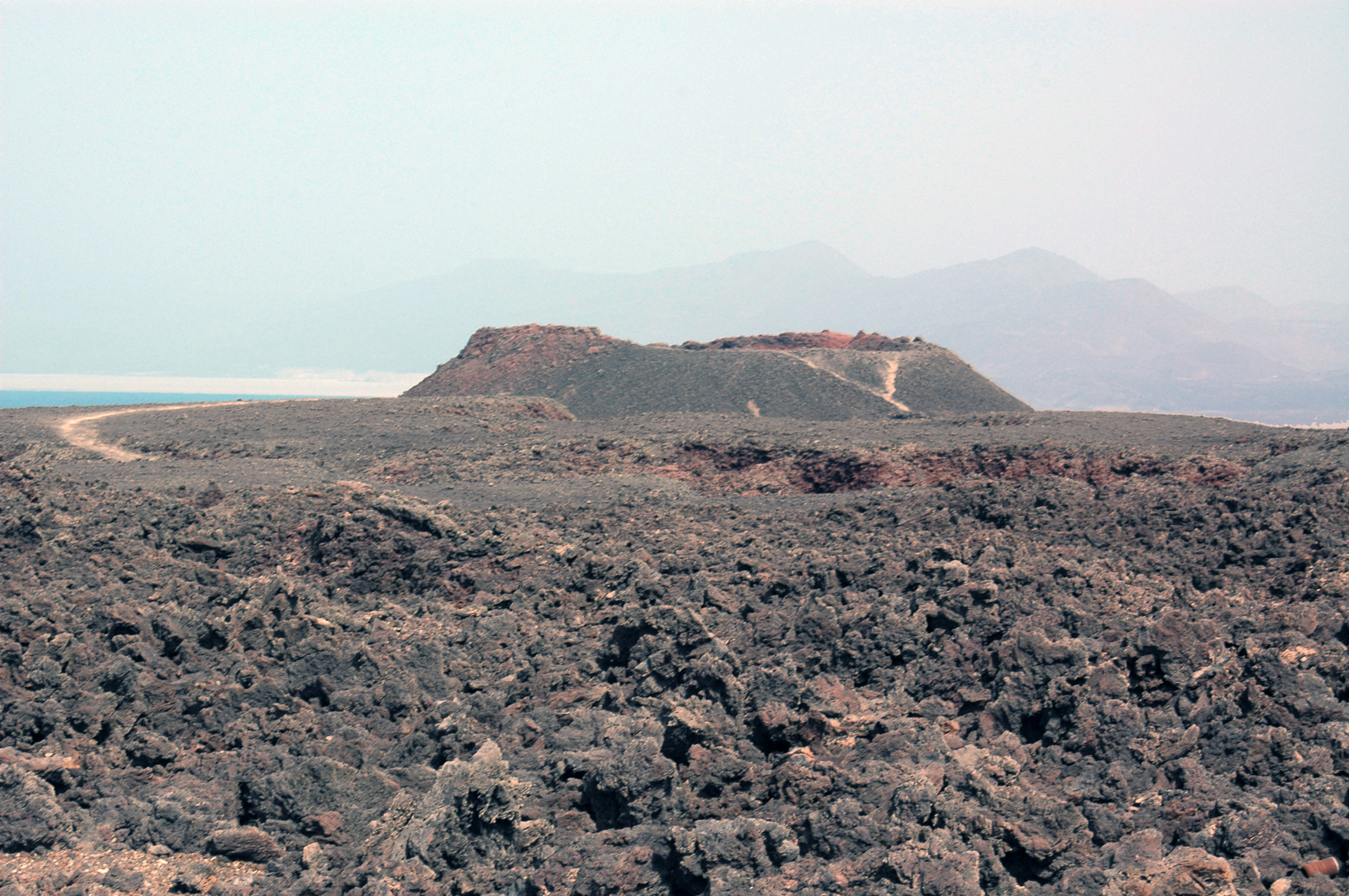
Ardoukôba Volcano is one of the most impressive geological experiences in Africa. It was born almost overnight: between 7 and 14 November 1978, after a series of earthquakes, the ground split open in the Asal Rift and lava fountains burst out, building a new cone in barely a week. It was a 'seven-day volcano' that scientists could watch almost live, an extremely rare event that put Djibouti on the map of world volcanology.
But what makes Ardoukôba unique is not just the cone, it is the ground around it. Here visitors walk among open cracks and faults, fresh lava flows and shifted blocks, right on the boundary between two tectonic plates. In this corner of the Afar Triangle, the Earth's crust is stretching and breaking, and the African continent is slowly separating from the Arabian Peninsula. It is, quite literally, the place where a future ocean is starting to open up.
This guide explains how to visit Ardoukôba from Djibouti City: how to get there along the coastal road, what to see on the cone and in the fissure field, how to combine it with Lake Assal and the Bay of Ghoubbet, when to go to avoid the extreme heat, and what precautions to take when walking on sharp lava in one of the youngest and most active landscapes on the planet.
Ardoukôba emerged in the eruption of 7 to 14 November 1978, a brief but historic episode in the Asal Rift, within the Afar Triangle, where the African and Arabian plates are pulling apart. Preceded by strong earthquakes, the eruption opened a fissure about 500 metres long from which lava fountains burst out and scoria cones formed; it was the first volcanic activity in the area in about 3,000 years. The event allowed scientists to measure the opening of the rift in real time. The full geological history is on our history page.
Read the full history ↓In the middle of the rift, where Africa is splitting from Arabia, Lake Assal marks the lowest point on the continent and the young Ardoukoba volcano is a reminder that the earth here is still opening up.
Read the history of The Great Rift: salt lakes and volcanoes →No exact prices: a scale from $ (budget) to $$$$$ (luxury), with 2-3 options per category.
Origins, formation and what the sources say.
To understand Ardoukôba, you need to look at the tectonic map of the Horn of Africa. Djibouti sits on the Afar Triangle, the point where three great fractures in the Earth's crust meet: the Red Sea ridge, the Gulf of Aden ridge and the Great African Rift Valley. Here, three plates (the African or Nubian, the Somali and the Arabian) are slowly pulling apart, stretching and thinning the crust. The Asal rift, between Lake Assal and Ghoubbet Bay, is the exposed segment of the Red Sea ridge: the only place in the world where you can walk on that ocean ridge on dry land.
In this setting, volcanism is the natural result of the fracturing. When the crust stretches and breaks, basaltic magma rises through the fissures and, every so often, reaches the surface. The floor of the Asal rift is covered in young eruptive fissures and cinder cones, evidence that the ground here is constantly renewing itself. Ardoukôba is the most recent and most famous of them all, because science watched it being born.
Dating shows that the most recent lava flows in the area are much younger than some sediments carbon-14 dated to around 5,300 years before present, and they are thought to be less than 3,000 years old. In other words, before 1978 the rift had gone about three millennia without a visible eruption. The fracture kept moving and building up stress until, in November that year, the energy was released all at once.
The Ardoukôba eruption began abruptly. On 7 and 8 November 1978, the region was shaken by two main earthquakes of magnitude greater than 5 and by some eight hundred smaller tremors. It was the sign that magma was forcing its way through the rift. After a brief phase of gas emission, lava fountains began along a newly opened fissure about 500 metres long, and several spatter cones formed on top of it.
The activity was intense but short. In the first hours, huge volumes of lava were extruded, up to half a million cubic metres per hour at peak flow. The rate dropped quickly, though, and by the fifth or sixth day it had fallen sharply. On 14 November, just a week after it began, the eruption died out. Because it was so brief, geologists nicknamed it the 'seven-day volcano', the 'seven-day wonder' of the Afar Triangle. What remained from that episode was the Ardoukôba cone and its black lava flows, which today are the visible heart of the site.
What was truly extraordinary was not so much the amount of lava, which was modest compared with other eruptions, as what it revealed about plate movement. During and after the event, the floor of the rift shifted: the two sides of the fracture suddenly moved more than a metre apart and the floor sank. It was like watching, squeezed into a few days, the process that takes centuries on ocean ridges. That is why the 1978 eruption became a classic case study in extensional tectonics.
The Ardoukôba eruption came at a time when the Asal rift was already being studied internationally. Since the 1970s, geologists and geophysicists had set up measuring networks in the area to monitor how the plates were separating. Many of them were French, given France's colonial ties with Djibouti and the cooperation that followed. The 1978 event was a unique opportunity: it made it possible to measure in real time how a fracture opens, how a magma dike intrudes and how the ground deforms. These data confirmed and refined the models of how oceans are born.
Since then, the Asal rift has been one of the most important natural laboratories in the world for studying crustal spreading. Every year, precision instruments record the two sides of the rift moving one or two centimetres apart, the same speed at which fingernails grow. Extended over geological time, this imperceptible movement means that millions of years from now the sea could flood the Afar depression and separate the Horn of Africa from the rest of the continent, creating a new ocean basin. Ardoukôba is a window onto that distant future.
For visitors, all this adds up to an unusual experience: walking on rock that formed in our grandparents' lifetime, looking into fissures that mark the boundary between two plates and understanding, with your feet on the lava, that the planet is alive and moving. Few volcanoes tell a story as clear and as recent as this low black cone lost in the Djibouti desert.
Today Ardoukôba is part of the great natural circuit of the Asal rift, together with Lake Assal and Ghoubbet Bay, which Djibouti promotes as its main tourist attraction. There are no facilities and no admission tickets: the site is a wild landscape you reach by 4x4 and explore on foot, ideally with a guide who knows the fissures and the terrain. The visit is almost always combined with a swim in Lake Assal and a stop to take in Ghoubbet, as a full-day trip from the capital.
The volcano is also a destination for geological hiking and adventure. Some operators offer longer walks through the rift, among lava flows, cones and fumaroles, for those who want to take time to understand the landscape. The nearby lowest point in Africa, the contrast with the salt of Lake Assal and the feeling of standing on a tectonic boundary make this area hard to forget.
Like the whole rift, the area around Ardoukôba is fragile and extreme. Summer heat can be deadly, the lava is sharp and there is no water or shade. Authorities and guides recommend visiting in the cool season, early in the day, with proper gear, keeping vehicles on the tracks, and without taking rocks or leaving rubbish. That way, this newborn volcano will remain one of the planet's great geological spectacles for a long time to come.