Viajá con Gus
HomePeruOllantaytambo
Ollantaytambo
🇵🇪 Peru · The Highlands and the Andes

Ollantaytambo

Jump to what you need
📍Region
Cusco, province of Urubamba, at the western end of the Sacred Valley (around 2,792 m above sea level)
📌Service town
The town of Ollantaytambo itself (fully serviced); Cusco and Urubamba as larger bases
📌Best time to go
Dry season from May to October (sunny days, cold nights). Rain from November to March
📌Suggested days
Half a day for the archaeological site; 1 or 2 days to enjoy the town and acclimatize before the train to Machu Picchu
💱 PEN exchange rate
Loading rate…
🌤️ Weather in Ollantaytambo
Loading weather…

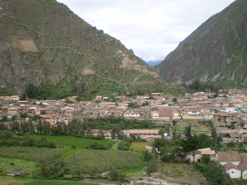
Ollantaytambo is one of the most extraordinary places in the Sacred Valley: at once an imposing Inca archaeological site and a living town on a pre-Hispanic street plan that is still inhabited. It sits at the western end of the valley, some 60-70 km from Cusco, on the Urubamba river, and is often called the 'Living Inca City' because its cobbled streets, water channels and blocks (the Inca canchas) keep the original layout from more than five centuries ago.

The archaeological complex climbs the hillside in a run of monumental terraces crowned by the unfinished Temple of the Sun, with its huge blocks of perfectly worked pink granite. It was a royal estate of the Inca Pachacútec and, during the conquest, the scene of one of the few Inca victories in open battle: in 1536-1537, Manco Inca held off the Spanish cavalry's attack from here.

For the traveler, Ollantaytambo plays two roles. It's an unmissable visit in its own right -the site, the town, the lookouts- and it's also the main departure point for trains to Aguas Calientes (Machu Picchu). Many choose to sleep here: it's lower than Cusco, it helps you acclimatize and it lets you catch the train at a relaxed pace the next morning. To enter the archaeological site you use the Cusco Tourist Ticket. Bring layers, sunscreen, water and good shoes: there's a fair bit of climbing up stone steps.

📖 History of Ollantaytambo

Ollantaytambo was one of the most important royal estates of the Inca Pachacútec, in the 15th century, and served agricultural, religious, administrative and military purposes. Its Temple of the Sun was left unfinished, possibly because the conquest broke in. In 1536-1537, Manco Inca turned the site into a stronghold of the resistance and defeated Hernando Pizarro's cavalry there, in one of the few Inca victories in open battle. More detail on the history page.

Read the full history ↓

🏛️ Ollantaytambo is in Cusco

The 'navel of the world': capital of the Inca empire and today the archaeological capital of the Americas, gateway to Machu Picchu, the Sacred Valley and the Vilcanota range.

Read the history of Cusco →

🗺️ What to see

1
Temple of the Sun (the six monoliths)
The most famous sector: an unfinished wall of six huge pink granite blocks weighing tens of tons each, fitted together with astonishing precision.
The Temple of the Sun is, without question, the image of Ollantaytambo you'll take home. It stands at the top of the ceremonial sector, and its great centerpiece is a wall made of six pink granite monoliths set side by side, separated by thin stone shims that worked as a kind of earthquake buffer. Each block is enormous: they're reckoned to be around four meters tall and to weigh tens of tons apiece. What leaves everyone speechless isn't just the size but the precision with which they were cut and joined, with no mortar in between. The fact that you're standing in front of an unfinished work, mid-construction when the Inca world broke apart, gives it a special aura: it's like looking at a photograph stopped in time. The most interesting thing about this sector is reading the clues about how it was built. You'll see blocks half set in place, others with bosses and knobs used to maneuver them with ropes, and remains of the ramp the stones came up from the valley on. The pink granite isn't from just around here: it came from the Cachicata quarry, on the other side of the Urubamba river, which gives you a sense of the brutal effort it took to move such masses uphill. If you go with a guide, ask them to point out the details of the joins and the tool marks, because they're easy to miss and they're the most impressive thing about the place. To get there you have to climb the whole terrace staircase from the complex entrance: it's the high point of the visit, so save some energy for the end. From the town of Ollantaytambo you're a few minutes' walk from the ticket office, and from Cusco you come through the Sacred Valley by shared car, van or taxi. The climb is up stone steps and you feel the altitude, so take it slowly and stop to rest. The best time to appreciate it is the dry season, May to October, when skies are clear and the pink stone catches the light. If you can, arrive early in the morning or close to closing time: fewer people, nicer light for photos and less heat. Bring water, a hat and sunscreen, because high-altitude sun is strong even when it isn't hot. To enter you use the Cusco Tourist Ticket; check the current rate, as the figures on file are for reference only.
ℹ️ Material: Pink granite brought from the Cachicata quarry, on the other side of the valley · The monoliths: Six large blocks in a row, several meters tall and tens of tons each · Condition: An unfinished work, probably interrupted by the Spanish conquest · Location: At the top of the ceremonial sector, at the end of the terrace staircase · Admission: Cusco Tourist Ticket (check the current rate)
2
Monumental terraces
The great staircase of terraces climbing the hillside, a symbol of Inca power and engineering; the climb gives spectacular views of the valley.
The first thing you see when you stand in front of Ollantaytambo is that great staircase of terraces climbing the hillside like a giant amphitheater. These are the monumental terraces, and beyond their farming function they carried enormous symbolic weight: they announced the Inca's power and served as a ceremonial approach to the Temple of the Sun crowning the summit. The stones of the retaining walls are so well worked and the scale so imposing that you understand why many consider them one of the finest pieces of engineering in the Andean world. It's worth taking a moment at the bottom, before you start climbing, just to look at the whole thing. As you go up, the reward opens out: each flight of steps gives a wider view of the town of Ollantaytambo, the Urubamba river and the mountains closing off the valley. On the terraces you can still make out the canal system and the water management the Incas mastered like few others, and you notice how they used the different levels and microclimates. It's a climb to do slowly, stopping for photos and to catch your breath, because the altitude is felt and the steps are high. The terraces are the only way up to the ceremonial sector and the Temple of the Sun, so the climb is a natural part of visiting the complex. From town it's a few minutes' walk to the entrance; from Cusco you come through the Sacred Valley. There's no easier alternative route: the charm is precisely in going up on foot and gaining height step by step. Best tackled in the dry season, May to October, and first thing in the morning or at dusk, when low light picks out the relief of the terraces and there are fewer people. Shoes with good grip, water and sun protection are essential. If you arrive somewhat acclimatized to the altitude, the climb is far more enjoyable; if you've just come up from low ground, take it patiently and breathe deeply at every stop.
ℹ️ What they are: Farming and ceremonial terraces in a monumental staircase up the hillside · Purpose: Farming, water management and symbolic approach to the Temple of the Sun · The draw: Wider and wider views of the town, the Urubamba river and the valley as you climb · Effort: A climb up high steps; the altitude is felt, best taken slowly
3
Enclosure of the Ten Niches (Inca Watana)
Finely cut stone walls in the upper ceremonial sector, with the trapezoidal niches typical of elite Inca architecture.
The Enclosure of the Ten Niches is one of those gems you'll walk right past if you're in a hurry, but that rewards anyone who looks closely. It sits in the upper ceremonial sector, near the Temple of the Sun, and you recognize it by its finely cut stone walls with a row of large trapezoidal niches -the hornacinas- perfectly aligned. Those niches, typical of elite Inca architecture, held ritual objects, offerings or images of deities, and their trapezoidal shape isn't decorative: it helped the walls stand up to earthquakes. The quality of the stonework here is first rate, reserved for the complex's most sacred spaces. This area is also associated with the Inca Watana, a space tied to astronomical observation, where priests tracked the movement of the sun and the stars to mark solstices and equinoxes. Walking among these walls you'll notice the difference from the rest of the site: the blocks are polished and fitted with a neatness that invites you to run a hand over them and understand why this was a space of worship and power. It's a good place to stop, slow down and let a guide explain the details you'd otherwise miss. You reach it on the same climb through the archaeological complex, once you top the terraces and enter the ceremonial sector. No special access is needed: it's on the visitor route. From the town of Ollantaytambo it's all on foot, and from Cusco you come as you would for the rest of the site, through the Sacred Valley. The best time is still the dry season, May to October, with good light for appreciating the texture of the stone. Since it's up top, you'll get here after a good stretch of steps, so pace yourself. Take it slowly, bring water and sunscreen, and set aside some time for this corner: it's one of the best displays of the mastery of Inca stonemasons.
ℹ️ What it is: A ceremonial enclosure with polished walls and a row of ten trapezoidal niches · What the niches were for: Holding ritual objects, offerings or sacred figures · Inca Watana: An area associated with observing the sun and stars to mark solstices and equinoxes · Location: Upper ceremonial sector, close to the Temple of the Sun
4
The Inca town of Ollantaytambo (the canchas)
The old town of blocks, cobbled streets and original water channels; one of the few settlements on an Inca street plan still inhabited.
If the archaeological site leaves your jaw on the floor for its scale, the town of Ollantaytambo wins you over with something more intimate: it's still being lived in. It's one of the very few settlements on an Inca street plan still inhabited, which is why they call it the 'Living Inca City'. The heart is the Qosqo Ayllu neighborhood, with its grid of perfect blocks called canchas: courtyards ringed by houses that keep their Inca base walls, on top of which families kept building over the centuries. Walking these narrow, straight cobbled streets is a trip into town planning from more than five centuries ago that never stopped being used. What surprises most is the detail of the water channels running through the streets: they're the same Inca aqueducts, still working, carrying clean water through town as they did hundreds of years ago. Step into one of the open canchas, look at the stone doorways, at the walls with their characteristic trapezoidal shapes and at how daily life -people, animals, weaving workshops- goes on among pre-Hispanic walls. It's an open-air museum that breathes. Take a slow wander, sit in the square, try something at the market and let the town's pace drop you down a gear. Best of all, walking the town is free: you don't need a ticket to get lost in its streets, unlike the archaeological site. You're right at the foot of the complex, so it combines perfectly: many people visit the ruins and then come down to walk the old town, or the other way round. From Cusco you get here through the Sacred Valley by shared car, van or taxi, and the town is small and very walkable. Any time of year works for a wander, though the dry season from May to October gives friendlier days. One big advantage: since it's lower than Cusco, sleeping here helps you acclimatize to the altitude and leaves you within reach of the train to Machu Picchu. Wear comfortable shoes for the cobbles, respect the fact that these are lived-in houses -not every courtyard is open to visitors- and make the most of dusk, when the light turns the stone golden and the town looks especially good.
ℹ️ Nickname: 'Living Inca City', one of the few towns on an Inca street plan still inhabited · Main neighborhood: Qosqo Ayllu, laid out in a grid of blocks called canchas · Water channels: Original Inca aqueducts still carrying water through the streets · Access: Free: walking the town's streets costs nothing · Advantage: It's lower than Cusco; ideal for acclimatizing before the train to Machu Picchu
5
Pinkuylluna (granaries on the mountainside)
Old storehouses (qollqas) clinging to the opposite slope; you climb up for free on a trail and get magnificent views of the site.
Pinkuylluna is Ollantaytambo's best-kept secret and, on top of that, free. These are the old Inca granaries -the qollqas- hanging off the mountain directly opposite the main archaeological site. The Incas built them high up on purpose: the cold, dry wind on the slope helped preserve the maize, potatoes and other produce stored inside. Today they look like rectangular stone buildings set into the hillside, and climbing up to them gives you one of the best views of the town and of the fortress seen from the other side of the valley. It's the ideal attraction for anyone who wants a bit of adventure and movie-grade views without spending a sol. The walk is short but steep: reckon on 30 to 45 minutes going up, depending on your pace and how often you stop for photos. The trail starts in town, on Qosqo Ayllu street, where a sign marks the turnoff to the colcas. It's a well-marked dirt and rock path, but watch every step, no headphones and no looking at your phone, because there are stretches beside sheer drops. Once you're up, take your time to walk among the different qollqas and find the best angle on the archaeological site across the way: you'll grasp the scale of the complex like from nowhere else. You don't need transport to get there: it all starts on foot from the square in Ollantaytambo. It's usually open during daylight hours (roughly morning to mid-afternoon) and admission is free, though you're generally asked to sign a visitors' book at the trailhead. Check the current opening times on the spot, since they can vary. The best time, again, is the dry season from May to October: in rain the trail turns slippery and dangerous, so don't go up if it's wet. Bring water, a hat, sunscreen and shoes with good grip, and tackle the climb early or late in the afternoon to dodge the strongest sun and get the nicest light. It's an hour and a half well spent that plenty of people miss simply because they don't know it's there.
ℹ️ What they are: Inca granaries (qollqas) on the hillside, used to store and preserve food · The walk: A steep climb of about 30 to 45 minutes from town · Starting point: Qosqo Ayllu street, with a sign marking the turnoff to the colcas · Admission: Free; you're usually asked to sign the visitors' book (check current opening times) · Watch out: Stretches beside sheer drops; don't go up in rain or on wet ground
6
The Cachicata quarry and the 'tired stones'
Across the valley, the quarries the blocks came from; stones left half-hauled still lie along the route.
The Cachicata quarry is the answer to the question everyone asks in front of the Temple of the Sun: where did those enormous monoliths come from? From here, from the slopes on the other side of the Urubamba river, several kilometers from town. It's a fascinating site because it shows you the start of the chain: where the pink granite was cut, how the blocks were roughed out at the quarry itself and which route took them down to the valley to be hauled up the ramp to the fortress afterward. For anyone interested in Inca engineering and logistics, walking Cachicata is what really makes you understand the feat of building Ollantaytambo. The big draw is the famous 'tired stones' (saicusca in Quechua): blocks already cut that were abandoned along the route, half-hauled, when the work stopped. Seeing them lying right on the trail, some of them colossal, is one of the site's most eloquent images: it makes you grasp the weight, the distance and the human effort behind every stone. On the way you'll also find remains of Inca roads, old chullpas (tombs) and splendid panoramic views of the Sacred Valley and the range. Getting there takes more determination than the other attractions: the usual way is as a half-day or full-day hike from Ollantaytambo, ideally with a guide or on an organized outing, because the terrain is open and it helps to know the route. Some stretches cross the river and climb the slope, so it's not a town stroll but a mountain outing. It isn't the typical visit for someone who's only here to catch the train, but it is a gem for anyone with a spare day who likes walking. The dry season, May to October, is clearly the best: in rain the paths get tricky and the views cloud over. Set out early, bring plenty of water, food, a hat, sun protection and hiking shoes, and tell someone your plan or go with company. For its distance and difficulty, Cachicata rewards the curious traveler who wants to go beyond the most-visited spots.
ℹ️ What it is: The Inca quarry the pink granite of Ollantaytambo was cut from · Location: Across the Urubamba river, several kilometers from town · 'Tired stones': Blocks already cut (saicusca) abandoned along the route, half-hauled · You'll also see: Remains of Inca roads, chullpas and panoramic views of the valley · How to visit: A half-day to full-day hike, better with a guide or on an organized outing
7
The 'face' of Wiracocha (Tunupa)
A natural rock formation on the mountain facing the site that many read as a carved or outlined face, tied to Andean mythology.
Facing the archaeological site, on Pinkuylluna hill, is one of those curiosities that make a visit magical: the so-called 'face' of Wiracocha or Tunupa. Looking at the slope carefully -and with a bit of imagination- you can make out the profile of an enormous face, many meters tall, formed by the rock's natural clefts and outcrops. Hollows in the mountain mark the eyes and forehead, while a jutting rock serves as the nose; some even see a beard and a bundle over the shoulder, as if it were carrying a sack. For many, the Inca structures at the summit act as a kind of crown on the figure's head. What's interesting is the mythology behind it. The figure is associated with Wiracochan or Tunupa, the messenger of the creator god Wiracocha, a civilizing character in the Andean worldview credited with teaching people how to grow, process and store food -it's no coincidence that he 'watches over' precisely the hill of the Pinkuylluna granaries. Whether it's an entirely natural formation or one enhanced at some point by human hands, what's certain is that for the ancient inhabitants this stone face was a guardian of the valley, and seeing it helps you understand how the Incas read the sacred into the landscape itself. You don't need any special access or ticket to see it: it's visible from several points in the town and the archaeological site of Ollantaytambo, and even better if you climb the Pinkuylluna trail, since the face is on that same hill. Ask a local or your guide to point it out the first time, because it's hard to spot on your own; once you've seen it, you can't unsee it. It works at any time of day, though morning light, hitting the slope from the side, brings out the features better and makes the profile easier to recognize. It's a free, evocative detail, perfect to combine with the walk up to the granaries and with discovering the symbolic weight every hill carried in the Andean world.
ℹ️ Where it is: On Pinkuylluna hill, facing the archaeological site · What it's said to depict: Wiracochan or Tunupa, messenger of the creator god Wiracocha · How it's formed: By natural clefts and outcrops in the rock that trace eyes, forehead and nose · Access: Free; visible from the town and better still from the climb up Pinkuylluna · Best moment: Morning light, when the low side sun picks out the features
8
The Fountain and Bath of the Ñusta (Princess)
A finely worked stone ceremonial fountain, with water still running through the Inca channels.
The Bath of the Ñusta -or Bath of the Princess- is a small marvel that shows just how far the Incas took the everyday into the realm of art. It's a ceremonial fountain carved from granite, with an aesthetic sensibility that catches your eye the moment you see it: the stepped motif (a hinted Andean chacana), the layered levels and the shapes worked into the sides make clear this was no ordinary fountain but a space loaded with symbolism. Tradition says the ñusta, the Inca's daughter or princess, bathed here in purification rituals, which is where the name comes from. Beyond the legend, what you see is the standing water held as a source of life. The detail that wins visitors over is that the water is still running, just as it was centuries ago. The fountain is part of a system of Inca aqueducts and channels that still works, and it flows from its outlets with a surprisingly steady stream. There's a classic trick many guides show: run a finger along the edge of the stone channel and the jet of water cuts off cleanly, proof of how refined the carving is. Take a moment to study the fine stonework, listen to the sound of the water and appreciate that you're looking at hydraulics and engineering from more than five hundred years ago, still alive. You reach the Bath of the Ñusta on the archaeological complex route, in the lower part of the sector, so you'll come across it without leaving the visitor path. From the town of Ollantaytambo it's all on foot to the site entrance, and from Cusco you come through the Sacred Valley as for the rest of the complex. It's covered by the Cusco Tourist Ticket; check the current rate. The dry season, May to October, gives the nicest light for taking in the detail of the stone. It's an ideal stop to do slowly, without the effort of the climb up the terraces, and it fits well with the rest of the visit. Bring the camera: the play of water on carved granite makes for lovely photos, especially in mid-morning.
ℹ️ What it is: An Inca ceremonial fountain carved in granite, tied to purification rituals · Name: Baño de la Ñusta or Bath of the Princess, after the Inca's daughter · Curiosity: The water still runs; run a finger along the edge and the jet cuts off · Location: Inside the archaeological complex, in the lower part of the ceremonial sector · Admission: Covered by the Cusco Tourist Ticket (check the current rate)
9
Ollantaytambo train station
The departure point for many trains to Aguas Calientes; handy for combining the visit with Machu Picchu.
Ollantaytambo train station isn't a 'monumental' attraction like the rest, but it's a key piece of the trip and it's worth knowing how it works, because most people heading to Machu Picchu pass through here. It's the most used station on the run to Aguas Calientes -the town at the foot of the citadel- and the one with the most trains toward the sanctuary. Two companies operate, PeruRail and Inca Rail, with several departures a day and different service classes, from the cheapest options to panoramic and luxury carriages. The train ride to Aguas Calientes takes roughly an hour and a half to two hours, following the Urubamba river through scenery that's already part of the show. The big advantage of leaving from Ollantaytambo rather than Cusco is that you skip the longest, earliest stretch: you sleep in town, which is lower and helps you acclimatize, and catch the train at a relaxed pace the next morning. The station is inside the town itself, very close to the center, so you get there on foot, by mototaxi or by taxi with your luggage in a few minutes from the square. There's a ticket office on site, but don't count on it: having your ticket booked in advance is the way to go. Coming from Cusco, the usual route is by road through the Sacred Valley -by shared car, van or taxi, around two hours- and then the train from there. Many people arrange their Sacred Valley tour to end in Ollantaytambo precisely to connect with the train at the end of the day or the next morning. It's convenient logistics, worth planning ahead. The most important practical point is booking: in high season (May to October) the trains fill up, so buy your tickets in advance. Fares vary a lot by company, departure time and class; check current prices directly with PeruRail or Inca Rail, as they change often. Get to the station with time to spare, check the baggage rules (suitcase size is usually limited) and have your ID and ticket to hand.
ℹ️ Purpose: The departure station for Aguas Calientes (Machu Picchu), the most used on the route · Companies: PeruRail and Inca Rail, with several departures and service classes · Train journey time: Approximately 1 h 30 to 2 h to Aguas Calientes · Location: Inside the town of Ollantaytambo, a few minutes from the square · Booking: Best bought in advance in high season; check current fares
Advertisements
What nobody tells you

💵 Prices

Tickets

TypePrice
Cusco Full Tourist Ticket (BTCI, 10 days; covers the Ollantaytambo Archaeological Park and 15 other sites on circuits I, II and III)S/ 130 foreign adult; S/ 70 foreign student; S/ 70 Peruvian visitor; S/ 40 Peruvian student (official COSITUC rate sheet; COSITUC is the committee that runs the ticket)
Partial Tourist Ticket, Circuit III — Sacred Valley (covers Ollantaytambo, Pisaq, Chinchero and Moray)S/ 70 foreign visitor, valid 2 days; S/ 40 Peruvian visitor, valid 1 day (official COSITUC rate sheet)
Opening hours of the Ollantaytambo Archaeological Park07:00 to 16:30, all year, according to the official record in MINCETUR's National Inventory of Tourist Resources. It has been run by the Cusco Decentralized Directorate of Culture (Ministry of Culture) since 1983
Cusco locals and residentsFree entry on showing a national ID card, according to the official MINCETUR record
Pinkuylluna (granaries)Free; open trail, not included in the Tourist Ticket and with no ticket office
The Inca town and lookoutsFree access: walking the town's streets costs nothing
🔄 updated monthlyOfficial / reference values · double-check when buying

Activities and tours

ActivityPriceDurationOperator
Visit to the Ollantaytambo archaeological siteIncluded in the Cusco Tourist Ticket (S/ 130 full or S/ 70 Sacred Valley circuit)1.5 to 2.5 hOn your own or with a local guide at the entrance
Local guide at the siteS/ 40-80 for a small group (source: accredited guides at the gate, verified July 2026)~1.5 hAccredited guides at the complex gate
Classic Sacred Valley tour (includes Ollantaytambo)US$ 20-45 per person + the tourist ticket separately (source: Cusco agencies, verified July 2026)Full dayCusco agencies
Walk up to the Pinkuylluna granariesFree~1.5 h round tripSelf-guided trail from the town
🔄 updated monthlyOfficial / reference values · double-check when buying
Advertisements

🚌 How to get there and distances

Getting around

ModePriceDurationNotes
Shared car/combi Urubamba → OllantaytamboS/ 2-5 per person (source: valley operators and viajesmachupicchu.travel, verified July 2026)~25-40 minThey leave often from the Urubamba stop; the cheapest way to move around the valley. Paid in cash (soles) straight to the driver or conductor: no card and no QR.
Mototaxi within the townS/ 2-5 a ride (source: visitor reports, verified July 2026)A few minutesUseful between the train station and the square if you have luggage. Cash payment; agree the fare before getting in.
Taxi Ollantaytambo → nearby stations/sitesS/ 10-30 depending on the ride (source: local taxi drivers, verified July 2026)VariableHandy for getting to the station with suitcases or combining with Maras/Moray. Uber and Cabify don't operate in the Sacred Valley: it's local taxis and shared cars, in cash.
App for planning the routeFree-In Cusco and the Sacred Valley the go-to app for seeing shared-car and combi routes in real time is Moovit (the 'Rutas Urbanas, Cusco' line); Google Maps also works for getting your bearings. In Cusco city the taxi apps InDrive and, more patchily, Uber also work; there's no coverage in the valley (source: Moovit and Cusco transport guides, verified July 2026).
Train Ollantaytambo → Aguas Calientes (Machu Picchu)From US$ 80 round trip in economy class (PeruRail Expedition / Inca Rail Voyager); US$ 140-180 round trip in mid class (Vistadome / 360°) (source: perurail.com and incarail.com via exploorperu.com, verified July 2026)~1 h 30 to 2 hOperated by PeruRail and Inca Rail; paid by card online or at the ticket office. Book ahead in high season (May-October).
🔄 updated monthlyOfficial / reference values · double-check when buying

How to get there

RouteAirlines / operatorsAvg. priceDuration
Lima → Cusco (plane)LATAM, Sky, JetSMART, Star PerúUS$ 45-215 depending on airline, how far ahead you book and the season (source: flight search engines, verified July 2026)~1 h 25-30 flying time
Cusco → Ollantaytambo (direct shared car/van, leaving from calle Pavitos)Valley shared cars and vans (calle Pavitos stop, near Av. Grau)S/ 10-20 per person in cash (source: Cusco transport guides, verified July 2026)~1 h 45 to 2 h
Cusco → Urubamba → OllantaytamboShared cars (change in Urubamba)S/ 8-15 in total, in cash (source: valley operators, verified July 2026)~2 h with the change
Private taxi Cusco → OllantaytamboTaxis and tourist transfersS/ 80-150 (source: taxi drivers and agencies, verified July 2026)~1 h 45
🔄 updated monthlyOfficial / reference values · double-check when buying

🏨 Where to stay

No exact prices: a scale from $ (budget) to $$$$$ (luxury), with 2-3 options per category.

CategoryPriceRecommended options
Boutique / high end$$$$$US$ 150-350 a night. The highest-rated registered hotel in town is the Pakaritampu (Ferrocarril 852), a few steps from the train station. WATCH THE LINK: the domain MINCETUR publishes for it, pakaritampu.com, no longer belongs to the hotel: it redirects to dubucmotors.com, an online betting site in Indonesian (verified on 08/08/2026). The hotel's registration is current; the domain is hijacked and should not be cited. Also at the high end, Tierra Viva Ollantaytambo (Ferrocarril 852) and the Tunupa Lodge (Ferrocarril 816). no rate published in an official source.
Mid range$$$$$US$ 60-120 a night. With current registration: Sol Natura Hotel (Ferrocarril 633), Intitambo (Coya Rumiyoc 215), Samanapaq (Cien Ventanas), Ccapaq Inka Ollanta (urbanización San Isidro) and La Orquídea Ollantaytambo Inn (Ferrocarril 406). no rate published in an official source.
Guesthouses with character$$$$$US$ 30-60 a night. Guesthouses with character in the Inca old town, all with current registration: Café Hospedaje Kiswar (Plaza de Armas), Hostal Iskay (Patacalle 722), Sol Miranda Boutique (Ventiderio), Andean Moon (Del Medio), Inka King (Chaupicalle 418) and Los Andenes (Ventiderio). no rate published in an official source.
Budget / backpacker$$$$$S/ 40-90 a night. Simple places with current registration: Wayra's Hostal (Ferrocarril), Tambo de Ollantay (Ferrocarril), Hostal Sauces (Ventiderio), Sol Ollantay (Ventiderio 226) and Inka Paradise (Mascabamba). no rate published in an official source.

🍴 Where to eat

TypePriceOptions / signature dish
Andean and novoandina cooking$$$$$S/ 40-70 a dish. In the town of Ollantaytambo, MINCETUR lists only two categorized restaurants: Sara Mama (Cachiccata bridge) and Restaurant Pizzería Mijunapaq (Convención s/n). The rest of what's on offer around the square is not in the national register. no rate published in an official source.
Traditional Peruvian food$$$$$S/ 20-35 a dish; set-menu restaurants with lomo saltado, ají de gallina, soups and trout from the Urubamba
Cafés and traveler-friendly options$$$$$S/ 12-25; handy cafés and pizzerias before catching the train, with good high-altitude coffee
Market and local food$$$$$S/ 8-15 for the set menu; stalls at the town market for cheap home cooking
Advertisements

📖 History of Ollantaytambo

Origins, formation and what the sources say.

A royal estate of Pachacútec in the Sacred Valley

In January 1537, Spanish cavalry charged uphill at Ollantaytambo and came apart: the Incas, dug in on the terraces, opened the channels, flooded the flat ground and the horses bogged down. It was one of the very few times an Andean army beat the conquistadors in open battle, and it happened at a place that had never even been conceived as a fortress. Ollantaytambo stands at the western end of the Sacred Valley, where the Urubamba river narrows between mountains on its way to the jungle. The site we admire today was largely built in the 15th century, during the reign of Pachacútec (Pachacuti Yupanqui, c. 1438-1471), the ruler who turned Cusco into the center of an expanding empire. After conquering the region, Pachacútec made it one of his royal estates and had the place reconfigured as a great center with agricultural, religious, administrative and military functions.

The name 'tambo' (tampu) points to its role as a resting, storage and control point on the Inca road network. That's why the complex combines very different elements: crop terraces climbing the hillside, food stores (qollqas) hanging on the mountain, administrative buildings, ceremonial fountains and a sacred sector at the top, presided over by the Temple of the Sun.

The engineering of Ollantaytambo still astonishes. The large pink granite blocks of the ceremonial sector were cut at quarries in Cachicata, on the other side of the valley several kilometers away. Moving those masses of tens of tons, crossing the river and hauling them up the slope was a logistical feat that combined ramps, human strength and an extraordinary command of stonework.

The Temple of the Sun and the six monoliths

The jewel of Ollantaytambo is the so-called Temple of the Sun, in the upper part of the complex. Its standout feature is a wall of six enormous pink granite blocks, perfectly cut and fitted, separated by thin stones acting as joints. The quality of the work -polished surfaces, millimeter-precise joins, barely hinted reliefs- belongs to the elite architecture reserved for the most sacred spaces of the Inca world.

One detail stands out: many stones were left half set in place and, along the route from the quarry, there are still abandoned blocks that locals call 'tired stones'. The most accepted explanation is that construction of the temple stopped abruptly, most likely because of the Spanish conquest and the war that broke out a few years later. That unfinished work is, paradoxically, one of the things visitors find most fascinating: it lets you picture the building process frozen in time.

From the Temple of the Sun and the upper terraces, the view of the town, the valley and the mountains is overwhelming. Opposite, on the far slope, stands Pinkuylluna, the group of Inca stores that used cold high-altitude winds to preserve food. The whole site works as an integrated system: production, storage, worship and control of the route toward the jungle.

Cachicata: the logistics behind the masterpiece

To grasp the scale of what was built at Ollantaytambo you have to cross the Urubamba river and reach the Cachicata quarry, several kilometers from the site, on the opposite slope of the valley. There Inca quarrymen found an outcrop of excellent pink granite and developed extraction techniques that combined dampened wooden wedges -which expanded as they dried until the rock split along its natural veins- with harder stone hammers for the initial roughing out of the blocks.

Once cut, the blocks had to travel several kilometers of rough ground, cross the Urubamba and climb the steep slope to the ceremonial sector. Archaeologists have identified the remains of ramps, paved roads and systems of rollers or logs probably used to slide the stones, as well as anchors carved into the blocks themselves -small bosses- for tying the ropes they were hauled with. It's reckoned that hundreds of coordinated workers were needed to move each of the large monoliths.

The so-called 'tired stones' (saicusca), blocks abandoned halfway between the quarry and the site, are the most eloquent testimony to this interrupted process. Studying them has let archaeologists reconstruct with remarkable precision how the production chain worked: from selecting the rock at Cachicata to the final assembly at the Temple of the Sun, a process that reveals a level of planning and labor organization comparable to the great public works of any ancient civilization.

Ollantaytambo and Manco Inca's resistance

Ollantaytambo holds a special place in the history of the conquest. In 1536, after rising against the Spaniards who had seized Cusco, Manco Inca turned the Sacred Valley into the stage of the resistance and made Ollantaytambo one of his strongholds. From the top of the terraces, the Incas commanded the flat ground any attack had to cross.

In January 1537, a Spanish cavalry expedition under Hernando Pizarro -Francisco's brother- tried to take the site. The Incas held out from the terraces, hurling stones, arrows and projectiles, and -according to the chronicles- diverted the water from the channels to flood the plain and stop the riders, whose horses bogged down. It was one of the few Inca victories in open battle against the Spanish, and it forced Hernando Pizarro to fall back toward Cusco.

The victory, though, was a breather rather than a turning point. Aware that he couldn't hold the position indefinitely against Spanish reinforcements, Manco Inca eventually withdrew to the Vilcabamba region, where the Inca state survived a few more decades as a rebel holdout. Today that episode makes Ollantaytambo not only a masterpiece of Inca engineering but also a symbol of Andean resistance.

Fortress, temple, or both?
Ollantaytambo is often called a 'fortress' because of its role in the war against the Spanish, but specialists stress that it wasn't conceived as a military fort in the strict sense. Its design answers above all to the agricultural, religious and administrative functions of an Inca royal estate; the andenes are first and foremost crop terraces and the base of the ceremonial site. That it worked so well as a defensive position in 1537 was less its original purpose than a use made of its commanding position over the valley.
Source: Cusco Perú — Ollantaytambo, Sacred Valley archaeological centers: https://www.cuscoperu.com/en/travel/sacred-valley-of-the-incas/archaeological-centers/ollantaytambo/

From colonial town to 'Living Inca City'

After Manco Inca withdrew to Vilcabamba, Ollantaytambo became part of Spanish-controlled territory, but unlike other Inca cities rebuilt on a new colonial grid, the town at the foot of the archaeological site kept its original Inca urban plan almost intact. The Qosqo Ayllu neighborhood held onto its grid of blocks (canchas) -courtyards ringed by houses-, its narrow, straight cobbled streets, and the channel system that distributed clean water throughout the settlement.

Across the colonial and republican centuries, Ollantaytambo families kept building on the original Inca foundations and walls, adding roofs, doors and later elements without destroying the pre-Hispanic base. That continuity, uncommon among the great Inca sites -most of which were abandoned or radically transformed-, is what allows Ollantaytambo to be called the 'Living Inca City' today: one of the few places in the world where an urban layout more than five centuries old is still inhabited and in full daily use.

In the 20th and 21st centuries, the growth of tourism to Machu Picchu turned Ollantaytambo into an unavoidable stop, thanks to its rail station serving Aguas Calientes. That new economic role brought the challenge of balancing the daily life of its residents -who still use the original canchas, channels and streets- with the growing flow of visitors, in a town that combines, as few in the world do, living archaeological heritage and contemporary life.

📚 Bibliography

  • Boleto Machu Picchu — Ruinas de Ollantaytambo: https://www.boletomachupicchu.com/ruinas-de-ollantaytambo/
  • Boleto Machu Picchu — Ollantaytambo: https://www.boletomachupicchu.com/ollantaytambo/
  • Wikipedia (ES) — «Templo del Sol (Ollantaytambo)»: https://es.wikipedia.org/wiki/Templo_del_Sol_(Ollantaytambo)
  • Wikipedia (ES) — «Batalla de Sacsayhuamán»: https://es.wikipedia.org/wiki/Batalla_de_Sacsayhuam%C3%A1n
  • Cusco Perú — Ollantaytambo, Sacred Valley archaeological centers: https://www.cuscoperu.com/en/travel/sacred-valley-of-the-incas/archaeological-centers/ollantaytambo/
  • Cocatambo — Sitio arqueológico de Ollantaytambo: https://cocatambo.com/blog/sitio-arqueologico-de-ollantaytambo
  • Andino Perú Tours — Historia del centro arqueológico de Ollantaytambo: https://www.andinoperutours.com/blog/historia-del-centro-arqueologico-de-ollantaytambo/
  • Wikipedia (ES) — «Ollantaytambo»: https://es.wikipedia.org/wiki/Ollantaytambo
  • Wikipedia (ES) — «Manco Inca Yupanqui»: https://es.wikipedia.org/wiki/Manco_Inca_Yupanqui

❓ Frequently asked questions

How much time do I need for Ollantaytambo?+
For the archaeological site reckon on 1.5 to 2.5 hours, because there's a fair bit of climbing up steps. Add more time to walk the Inca town, its streets and channels, and possibly to climb up to the Pinkuylluna granaries for free. If you sleep here, you can take it far more slowly and make the most of morning or evening light.
Which ticket do I need?+
To enter the archaeological site you use the Cusco Tourist Ticket, either the full one (several days, covering sites in Cusco and the valley) or the partial Circuit III, specific to the Sacred Valley. Walking the town and climbing to the Pinkuylluna granaries costs nothing.
Is it worth sleeping in Ollantaytambo?+
For many travelers, yes. It's lower than Cusco (around 2,800 m), so it helps you acclimatize to the altitude, and it's the departure point for many trains to Aguas Calientes. A classic formula is to tour the Sacred Valley, sleep in Ollantaytambo and take the train to Machu Picchu the next day, without such an early start.
Does the train to Machu Picchu leave from here?+
Yes. Ollantaytambo is the most used station for getting to Aguas Calientes, the town at the foot of Machu Picchu. PeruRail and Inca Rail operate, with several departures a day and different service classes. Book ahead, above all in high season (May to October).
Why do they say the Temple of the Sun is 'unfinished'?+
Because several of its stones were left half set in place and there are large blocks abandoned along the route from the quarry (the famous 'tired stones'). The most widespread reading is that the work stopped with the Spanish conquest, though the site still impresses for the scale and precision of the six pink granite monoliths.
Is the climb physically demanding?+
It takes some effort: there are a lot of stone steps and the altitude is felt. If you go slowly, take breaks and are somewhat acclimatized, most people manage it. Bring water, a hat and sunscreen; high-altitude sun is strong even when it isn't hot.
Can it be combined with Maras and Moray?+
Yes, many people combine them in a day through the valley: Pisac or Chinchero in the morning, Maras and Moray at midday and Ollantaytambo in the afternoon, ending by catching the train. Note that the Maras salt pans are paid separately; they aren't in the Tourist Ticket.
How do I get around the Sacred Valley and how do I pay for transport?+
The cheapest option is shared cars and combis: for Ollantaytambo they leave from the calle Pavitos stop (near Av. Grau) in Cusco, or from Urubamba, and cost S/ 8-20. They're always paid in cash (soles) to the driver or conductor: no card and no QR in the valley. Within Ollantaytambo you get around on foot or by mototaxi (S/ 2-5). To see routes and times in real time use the Moovit app (the 'Rutas Urbanas, Cusco' line) or Google Maps. Taxi apps such as Uber or InDrive work in Cusco city, but not in the valley.
Sources consulted (10)
Still planning?
Explore more destinations in Peru
See all destinations →
Advertisements
Image credits
Photos from Wikimedia Commons, each under its own licence (CC BY, CC BY-SA or public domain). Open each file to see its author and licence.
Ollantaytambo 2