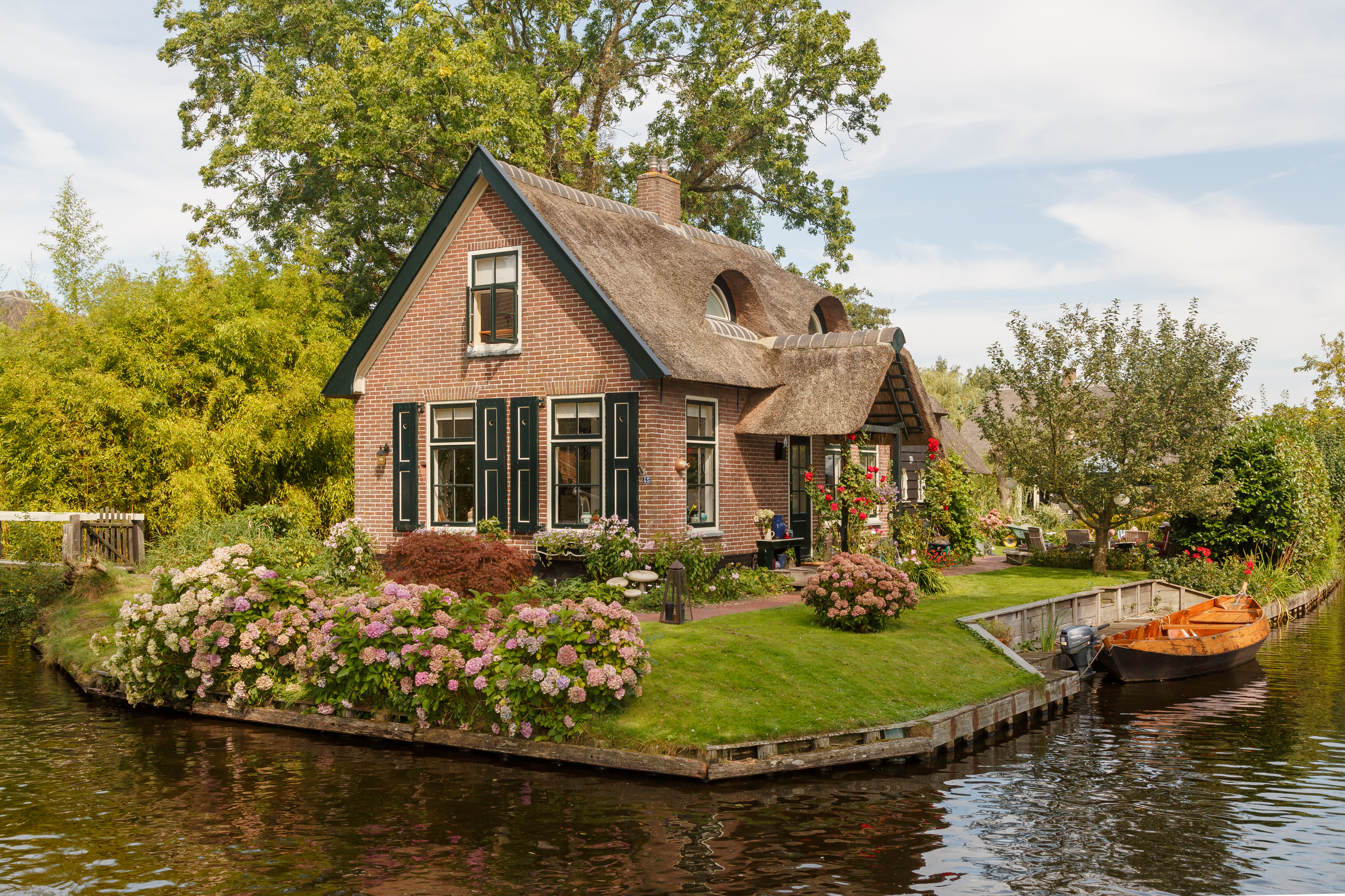
Giethoorn is one of those postcards that look too pretty to be real: a village with no streets, where reed-thatched houses are spread over green islets linked by more than 180 little wooden bridges, and where the silence is broken only by the lapping of water and the barely audible hum of electric boats. They call it the 'Dutch Venice' or 'the village with no roads', and there are no cars in the old centre: many houses can be reached only on foot or by boat. It lies in the north of the country, in the heart of Weerribben-Wieden National Park, the largest peat bog in northwestern Europe.
Giethoorn's charm is not a stage set: it is the direct result of its history. The maze of canals that enchants visitors today was dug, unintentionally, by the peasants who for centuries cut peat out of these bogs to use as fuel. By opening ditches to move the material, they gradually traced the network of water that shaped the village, while the land left between one canal and the next turned into islands. With patience, timber and reeds, the inhabitants built one of the most singular rural landscapes in the Netherlands on top of it.
This guide covers Giethoorn with a practical, honest eye: how to get there (which has its trick, because there is no train), how to navigate its canals in a whisper boat, what to see and which museum to visit, and — very important — how to avoid the tourist saturation trap that in high season can ruin the experience. Because Giethoorn, visited calmly and at the right hour, is still one of the most magical corners of Holland; visited at midday in the middle of August, it can be a parade of launches. Here is how to see it properly.
Giethoorn was founded, according to tradition, around 1230, when a group of settlers — remembered as flagellants, a medieval penitential sect, arriving according to legend from southern Europe — settled in this area of bogs and peat. Digging the ground they found large quantities of wild goat horns, remains probably washed in by a great flood in 1170; so they called the place 'Geytenhoren' ('goat horn' in old Dutch), which over time became Giethoorn. For centuries the village lived from cutting peat (the 'fuel' of the era): by opening ditches to extract and move the peat, the inhabitants gradually created the network of canals, and the land left between them became islets. The large excavations also gave rise to the lakes in the area. It was also a land of Mennonite (Anabaptist) communities, which left their mark on the sober, hard-working character of the place. Giethoorn was a poor, isolated village until, in 1958, the Dutch filmmaker Bert Haanstra shot his celebrated comedy 'Fanfare' there, which showed its canal landscape to the whole country and launched its fame as a destination. The full history is on our history page.
Read the full history ↓The extremes of the Netherlands: Maastricht, the Roman city of the south where the treaty that created the European Union was signed in 1992; the lake village of Giethoorn; Groningen, the Hanseatic city of the north transformed by gas; and Friesland, with a language of its own, and the Wadden Islands, a natural World Heritage Site.
Read the history of South and north →If you book from here we earn a commission and you pay no more. Prices and availability come from Civitatis.
No exact prices: a scale from $ (budget) to $$$$$ (luxury), with 2-3 options per category.
Origins, formation and what the sources say.
The name Giethoorn conceals one of the most curious origin stories in the Netherlands, half legend and half geology. According to tradition, around 1230 a group of settlers established themselves in this marshy area in the north of what is today the province of Overijssel. They are remembered as flagellants — a penitential sect of medieval Europe whose members whipped themselves as an act of devotion — who, legend says, came from the south of the continent fleeing persecution.
As they began to cut peat from these bogs, those first settlers came across an enormous quantity of wild goat horns buried in the ground. They are thought to have been the remains of animals killed and washed there by a great flood in 1170, one of the many water disasters that struck the Dutch low countries in the Middle Ages. Impressed by the find, they called the place 'Geytenhoren' ('goat horn', in old Dutch). Over the centuries the name shifted — Geythorn, Gietho(o)rn — until it settled as today's Giethoorn.
However much of the flagellant story is legend, what is certain is that Giethoorn began as a humble settlers' community in a very harsh environment: a landscape of water, reeds and peat, cut off from the rest of the country, where life depended entirely on what could be taken out of the marsh. That environment, and the work of generations on it, would end up shaping the unique village we know today.
The feature that makes Giethoorn a marvel — its maze of canals, islets and bridges, without a single street in the old centre — was designed by nobody. It is, literally, the by-product of centuries of exhausting labour: peat cutting. Understanding that is understanding the village.
Peat (in Dutch, 'veen' or 'turf') is half-decomposed plant matter that builds up in boggy ground and, once dry, burns as fuel. For centuries it was the great fuel of the Netherlands, in a land with barely any timber or coal. From the thirteenth century, and with an enormous boom from the seventeenth century onwards, Giethoorn's economy revolved around cutting peat out of these bogs. The inhabitants dug long ditches to drain the ground, cut the peat into blocks and left it to dry on raised strips of land before selling it.
Moving those blocks to buyers required waterways, so they gradually widened the ditches and opened canals. As the peat was emptied out, the ground sank and fragmented: the firm land left between one canal and the next became a succession of islets, each just big enough for a house and its vegetable garden. So, with no plan at all, the structure of the village 'with no streets' was born, where everything is connected by water.
The process had its destructive side too. Two great floods, in 1776 and in 1825, swept away the fragile strips where the peat was dried and inundated wide areas: from them came many of the lakes that surround Giethoorn today, such as the Bovenwijde, and much of the watery landscape of today's Weerribben-Wieden National Park, the largest continuous peat bog in northwestern Europe. Nature and human labour combined, over centuries, to sculpt this amphibious territory.
For centuries Giethoorn was a poor, isolated village deeply marked by water. There were no roads connecting it to the world, and all of daily life was organised around the canals: people went to church, to market, to school or to a funeral by boat; house moves, livestock, milk, peat and even the bride and groom on their wedding day travelled by water. The postman delivered by boat, as he still does across much of the old village. That total dependence on water forged a very particular culture and set of customs.
The silent protagonist of that life was the 'punter', Giethoorn's traditional boat: a long, narrow wooden craft (about 6 metres long by little more than a metre wide), flat-bottomed, propelled by pole or sail, and the village's universal vehicle. Peat, hay, cows and people all travelled by punter. The traditional boatyards that built them ('punterwerf') are part of the local heritage, and they are still made and used today.
Giethoorn was also a land of Mennonite (Anabaptist) communities, a Protestant current that emerged in the sixteenth century preaching a sober, pacifist faith based on work and simple living. The Mennonites left their mark on the austere, hard-working, communal character of the area, and they had a significant presence here for generations. All of that life — that of the bog farmer and fisherman, with their reed-thatched houses, their box beds and their tools — is what the Het Olde Maat Uus museum recreates today, set in a genuine village farmhouse, so visitors understand that behind the idyllic postcard lie centuries of humble work and effort.
Giethoorn might have gone on being a lost and unknown corner of the Netherlands had it not been for a film. In 1958 the Dutch filmmaker Bert Haanstra — one of the great names of his country's documentary and fiction cinema — chose the village of canals as the setting for his comedy 'Fanfare'. In the film, Giethoorn appears under the fictional name of 'Lagerwiede'.
The story of 'Fanfare' is an ensemble comedy of manners: in a small village, a dispute between the owners of two rival cafés ends up splitting the local brass band (the 'fanfare') in two, and the rivalry between the two resulting bands gets out of hand, with a courting couple from opposing sides caught in the middle, in an almost Romeo and Juliet key but with a happy ending. Shot in Giethoorn's unmistakable landscape of canals, bridges and thatched houses, the film was an enormous hit: it remains one of the best-loved and highest-grossing Dutch comedies in history.
The impact on the village was immense. 'Fanfare' showed the whole country — and later foreigners — that magical place where people travelled by boat instead of by car, and it set off curiosity and tourism. What had been a poor community of peat cutters began, little by little, to turn into one of the most photographed destinations in the Netherlands, the celebrated 'Dutch Venice' or 'Venice of the north'.
It took barely a few decades to go from forgotten peat-cutting village to global phenomenon. In the twenty-first century Giethoorn became a world-famous destination, driven by social media, guidebooks and, very particularly, enormous popularity in Asia: the village became a magnet for Chinese and other Asian visitors, who include it as an obligatory stop on their European tours. Added to that are the crowds of day trippers arriving every day from Amsterdam and other cities.
That fame has a dark side, which is worth telling honestly. In high season — the summer months and fine-weather weekends — Giethoorn suffers heavy tourist saturation: a village of fewer than 3,000 inhabitants sometimes receives hundreds of thousands of visitors a year, and in the middle of the day the narrow canals get congested with boats and the pedestrian path fills with people. At those moments much of the charm and calm that made the place famous simply vanishes, and for the residents who live there the pressure is considerable. It is the classic 'overtourism' dilemma: the same tourism that gives the village its economic life threatens to strip it of its character.
The good news is that Giethoorn can still be enjoyed at its best, and the key is timing. Visiting early in the morning or late in the afternoon, midweek or outside high season, and heading out by boat towards the canals and lakes of Weerribben-Wieden National Park, brings back the quiet, silent, magical village of old: the one of reflections in the water, wooden bridges, flowering gardens and the barely audible hum of an electric boat gliding between the thatched houses. It is still, without exaggeration, one of the most singular and beautiful corners of the Netherlands; you just have to know when to go.