Viajá con Gus
HomeUnited StatesMartha's Vineyard
Martha's Vineyard
🇺🇸 United States · New England

Martha's Vineyard

Jump to what you need
📌State
Martha's Vineyard is an island in the Atlantic Ocean belonging to the state of Massachusetts (New England), off the southern coast of Cape Cod, from which it is separated by the Vineyard Sound strait. Together with the nearby island of Chappaquiddick and the Elizabeth Islands, it forms Dukes County. It is the largest island in New England and is organized into six towns: Edgartown, Oak Bluffs and Vineyard Haven (the three 'Down-Island' ones, the more touristy) and West Tisbury, Chilmark and Aquinnah (the 'Up-Island', more rural). The island is a summer destination famous for its beaches, lighthouses, gray-shingled houses and for having been a retreat for presidents and celebrities.
📌Service town
Vineyard Haven (in the town of Tisbury) and Oak Bluffs are the main ferry arrival ports and concentrate services, shops and lodging; Edgartown is the historic and most elegant center. The island has a small airport, Martha's Vineyard Airport (MVY), with regional flights (more frequent in summer). The most common way to arrive is by ferry, above all from Woods Hole (on Cape Cod), with the Steamship Authority, and also from Hyannis, Falmouth, New Bedford and, in season, from other points. The region's great air gateway is Boston's Logan Airport (BOS), from where you combine with a ferry or a regional flight.
📌Best time
Summer (from late June to early September) is the classic high season: warm weather, beaches in full swing, every business open and plenty of activity, but also plenty of people and high prices; you have to book lodging and ferry (especially if you are bringing a car) well in advance. Autumn (September and October) is for many the best time, with pleasant weather, fewer crowds, foliage and better prices. Spring is quiet and full of flowers. In winter the island turns into a snug, silent place, with several businesses closed, ideal for anyone looking for peace.
📌Suggested days
With 2 days you cover the essentials: the historic center of Edgartown and its lighthouse, the famous 'gingerbread cottages' and the carousel in Oak Bluffs, and a beach. With 3 to 5 days you enjoy the whole island at an easy pace, adding the colored clay cliffs of Aquinnah (Gay Head) with their lighthouse, the Up-Island beaches, a bike ride along the flat paths, a trip on the little ferry to Chappaquiddick island and time to eat seafood by the harbor. Martha's Vineyard is best enjoyed unhurried, alternating towns, beaches and rural landscapes.
💱 USD exchange rate
Loading rate…
🌤️ Weather in Martha's Vineyard
Loading weather…

Martha's Vineyard is one of those islands that seem made for summer. Set off the southern coast of Cape Cod, in Massachusetts, it is the largest island in New England and a destination that combines sandy beaches, white lighthouses, colored clay cliffs, houses of salt-weathered gray shingles and towns with a classic New England charm. Presidents summered here —Barack Obama chose the island on several occasions— along with celebrities, but it is also a place of fishing communities, farmers and families who come back generation after generation.

The island has two halves with distinct characters. The 'Down-Island', with the towns of Edgartown, Oak Bluffs and Vineyard Haven, is the liveliest and most touristy area: Edgartown dazzles with its white whaling captains' mansions and its lighthouse; Oak Bluffs surprises with its neighborhood of colorful little wooden houses trimmed with lacework, the famous 'gingerbread cottages', its historic carousel and its lively harbor. The 'Up-Island', with West Tisbury, Chilmark and Aquinnah, is more rural and quiet, of farms, woods, ponds and the spectacular clay cliffs of Aquinnah (Gay Head), territory of the Wampanoag people.

This guide tours Martha's Vineyard with a practical, warm eye: how to arrive by ferry and get around the island, which towns and lighthouses to visit, where the best beaches are, how to explore it by bicycle and where to eat lobster and fresh oysters. The island can be enjoyed without a car if you organize yourself, combining bike, bus and ferry, and it gives you quiet days of sea, landscape and postcard towns.

📖 History of Martha's Vineyard

Long before the Europeans arrived, Martha's Vineyard was the territory of the Wampanoag people, who called it 'Noepe' (sometimes translated as 'land amid the currents') and lived off fishing, shellfishing, hunting and farming. In 1602, the English explorer Bartholomew Gosnold sailed these waters and gave the island the name 'Martha's Vineyard', by tradition in honor of a Martha in his family (possibly his daughter or his mother-in-law) and for the wild grapevines he found there. English colonization began around 1642 with Thomas Mayhew, whose family governed the island for generations and kept, unlike other areas, relatively less violent relations with the Wampanoag, many of whom converted to Christianity. In the 18th and 19th centuries, the island prospered on fishing and, above all, on whaling, which made Edgartown rich and filled its streets with captains' mansions. In the mid-19th century, Oak Bluffs was born as the site of huge open-air Methodist religious camp meetings, whose tents turned over time into the celebrated 'gingerbread' wooden cottages. With the decline of whaling, the island reinvented itself as a summer destination, a role it keeps to this day. The Wampanoag people of Aquinnah (Gay Head) maintain their identity and their land at the western end of the island. The full story is on our history page.

Read the full history ↓

🏛️ Martha's Vineyard is in Massachusetts

The cradle of the nation: Wampanoag land where the Mayflower pilgrims landed, stage of the Revolution in Boston, home of Harvard and of the summer season on Cape Cod and Martha's Vineyard.

Read the history of Massachusetts →

🗺️ What to see

1
Edgartown and the Edgartown Lighthouse
The island's elegant historic town, with white whaling captains' mansions, cobbled streets and its lighthouse beside the harbor.
Edgartown is the oldest and most elegant town on Martha's Vineyard, and the one that best preserves the mark of the golden age of whaling. In the 19th century, the whaling captains who grew rich on the high seas built imposing white mansions here in the Federal and Greek Revival styles, with manicured gardens, white fences and columned porches. Walking its streets, especially North and South Water Street, is like touring an open-air museum of that maritime prosperity. The town has a compact center that is a pleasure to explore on foot, full of boutiques, galleries, restaurants and cafés, plus white-steepled churches and the Martha's Vineyard Museum (which tells the island's story). Its harbor, busy with sailboats and yachts in summer, is one of the prettiest in New England. At the harbor entrance stands the Edgartown Harbor Light, a small, photogenic white lighthouse you reach by walking along a beach, and one of the most photographed spots on the island, above all at sunset. Edgartown is also where the little 'On Time' ferry leaves, crossing in a few minutes to Chappaquiddick island, a quiet corner of wild beaches and nature reserves. How to get there: Edgartown is in the southeast of the island; you reach it by car, bus or bike from the ports of Vineyard Haven and Oak Bluffs. Best time: summer for the atmosphere; sunset for the lighthouse. Tips: parking downtown is limited in season, so it is better to arrive by bus or bike. Combine the walk through the historic center with the lighthouse and, if you have time, a trip over to Chappaquiddick.
ℹ️ Distance: Southeast of the island; bus or bike from Vineyard Haven and Oak Bluffs · Best time: Summer for the atmosphere; sunset for the lighthouse · Admission: The town and the lighthouse (from the outside) are free; Martha's Vineyard Museum approx. US$ 18 adults, US$ 9 children (2025; check when you visit) · Duration: Half a day
2
Oak Bluffs: the gingerbread cottages and the carousel
The island's most colorful and festive town, with its 'gingerbread' wooden cottages and the oldest carousel in the United States.
Oak Bluffs is the most cheerful and singular town on Martha's Vineyard, and it has a very particular origin: it was born in the mid-19th century as the site of Methodist religious camp meetings. Every summer, thousands of the faithful camped in tents around a tabernacle to attend prayer gatherings. Over time, the tents were replaced by small wooden houses, lavishly decorated with lacework trim and filigree painted in bright colors, which look like storybook or gingerbread houses: these are the famous 'gingerbread cottages' of the Martha's Vineyard Camp Meeting Association, today a charming and highly photogenic neighborhood around its iron Tabernacle. The town also has a lively harborside promenade, full of restaurants, ice cream parlors and shops, and an atmosphere more bustling and diverse than the rest of the island. Its great attraction for children and adults alike is the Flying Horses Carousel, considered the oldest operating carousel in the United States (from the 1870s), with hand-carved wooden horses and the classic game of grabbing the brass ring. Oak Bluffs is also known for its historic African American community of summer residents, which for more than a century has made the island —and especially this town and Inkwell Beach— a place of gathering and memory. At night, Oak Bluffs is the town with the most nightlife on the island. How to get there: it is one of the ferry ports, so you arrive directly by boat, or by bus/bike from the rest of the island. Best time: summer, when the atmosphere is in full swing. Tips: walk through the gingerbread cottage neighborhood with respect (they are lived-in homes), ride the carousel and enjoy the sunset by the harbor. It pairs very well with a day at a nearby beach.
ℹ️ Distance: Northeast of the island; ferry port, bus and bike · Best time: Summer for the atmosphere and the nightlife · Admission: The neighborhood is free; the Flying Horses Carousel costs approx. US$ 3,50 per ride (2025; check when you visit) · Duration: Half a day
3
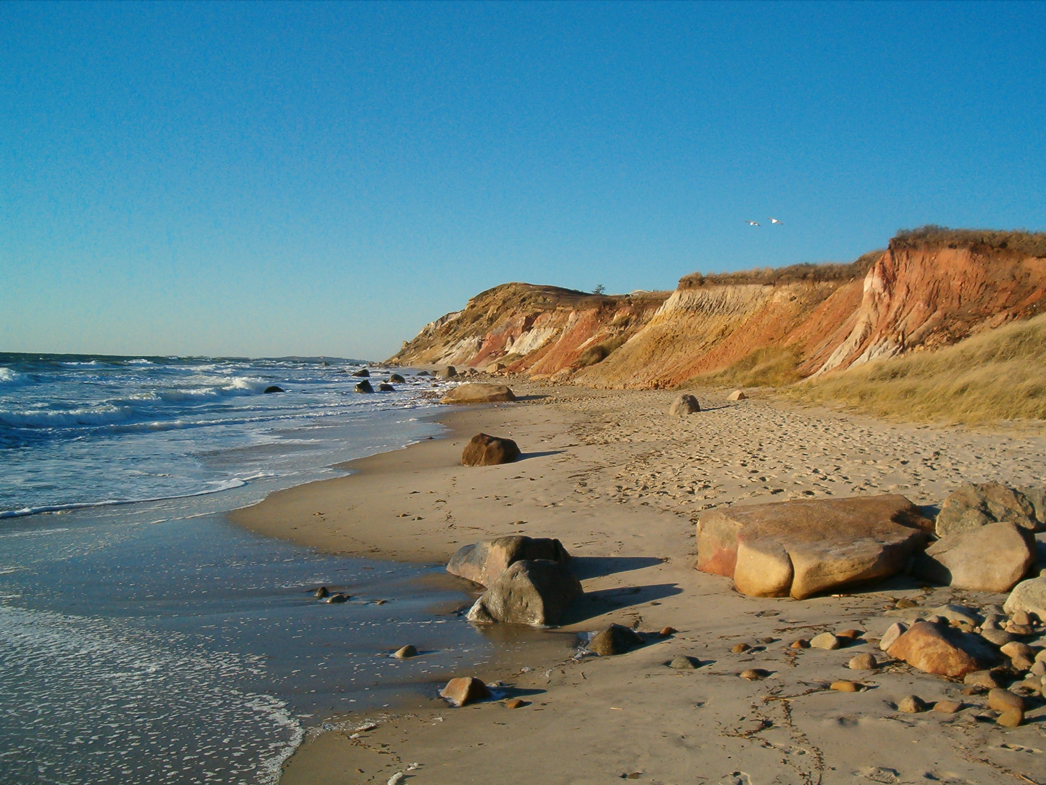
The Aquinnah (Gay Head) cliffs and lighthouse
The spectacular colored clay cliffs at the western end of the island, with their lighthouse, in the territory of the Wampanoag people.
The Aquinnah Cliffs, also known by their old name of Gay Head, are one of the most impressive landscapes on Martha's Vineyard and a National Natural Landmark. They are tall clay cliffs at the western end of the island, whose geological layers, exposed by the erosion of the sea, unfold a palette of colors —ochres, reds, oranges, grays and whites— that shifts with the light of day and is especially beautiful at sunset, when the sun sets them ablaze. The clays hold fossils that tell millions of years of geological history. This area is the heart of the Wampanoag people of Gay Head (Aquinnah), one of the recognized tribal communities of Massachusetts, which keeps its land and identity here. The cliffs are a sacred place for them, so taking the clay or going down into certain areas is forbidden; always respect the signs. Up top there are viewpoints with spectacular views over the ocean and, on clear days, of the Elizabeth Islands. Above the cliffs stands the Gay Head Light, a red brick lighthouse, the oldest on the island, which was also moved inland a few years ago to save it from erosion. Beside the viewpoints there is a small cluster of craft and food stalls run by the community. Below, Aquinnah beach (Moshup Beach) is one of the wildest and most beautiful on the island. How to get there: it is Up-Island, at the western end; you reach it by car or bus from the Down-Island (it is a long trip, worth planning). Best time: sunset is magical for the cliffs; the morning for the beach. Tips: respect the ban on touching or taking the clay, bring water and comfortable shoes for the walk down to the beach, and check the lighthouse visiting hours.
ℹ️ Distance: Aquinnah, western end (Up-Island); car or bus from the Down-Island · Best time: Sunset for the cliffs; morning for the beach · Admission: Viewpoints free; Aquinnah parking approx. US$ 15–20 per day in summer; climbing the Gay Head Light approx. US$ 12 adults (2025; check when you visit) · Duration: Half a day (with the trip there)
4
The beaches of Martha's Vineyard
From the calm beaches on the sound to the wild Atlantic ones, with pale sand and water for every taste.
The beaches are one of the great attractions of Martha's Vineyard, and the island offers variety for every taste. On the north side, facing Vineyard Sound (the strait that separates it from Cape Cod), the water is calmer, warmer and family-friendly: that is the case with the beaches near Vineyard Haven and Oak Bluffs, such as the historic Inkwell Beach. On the south side, open to the Atlantic Ocean, the beaches are broader and wilder, with surf and a rougher character. Among the most famous are South Beach (Katama), a long strip of sand near Edgartown, very popular in summer for its waves; Joseph Sylvia State Beach, between Oak Bluffs and Edgartown, known for its calm waters (and for having been a location for the film 'Jaws', shot on the island in 1974); and Moshup Beach, at the foot of the Aquinnah cliffs, one of the most spectacular. Chappaquiddick island, across from Edgartown, also hides beaches and nature reserves with very few visitors. Keep in mind that some beaches are public and freely accessible, while others are reserved for residents or require a parking permit, above all Up-Island. In summer, the parking beside the most popular beaches fills up early, which is why many visitors arrive by bike, bus or shuttle. Watch out for the currents on the ocean beaches and respect the lifeguards' signs. How to get there: depending on the beach, by car, bus, bike or shuttle from the towns. Best time: summer for swimming; spring and autumn for walking. Tips: find out in advance which ones are freely accessible and where you can park; bring water, shade and sunscreen, and on the southern beaches, mind the waves and currents.
ℹ️ Distance: Spread across the whole island (calm north, oceanic south) · Best time: Summer for swimming; spring and autumn for walking · Admission: Several beaches are free; some are restricted to residents or have paid parking of approx. US$ 15–20 per day in season (2025; check when you visit) · Duration: Half a day or more
5
Vineyard Haven (Tisbury)
The island's main port, with its lively center, traditional sailboat yards and seafaring atmosphere.
Vineyard Haven, in the town of Tisbury, is the main gateway port of Martha's Vineyard and the one where most ferries arrive all year round. It is a town with a strong seafaring character, with a working harbor, traditional boatyards where wooden sailboats are still built and repaired, and a pleasant shopping center around Main Street, full of shops, bookstores, cafés and restaurants. Unlike Edgartown (more elegant) and Oak Bluffs (more festive), Vineyard Haven has a more everyday, authentic air, the feel of a town where life goes on all year. It is a good place to start getting to know the island, do some shopping, rent bicycles or catch the bus to other towns and beaches. The harbor, full of sailboats, is very pretty and keeps the tradition of classic sailing alive, with regattas and gatherings of wooden vessels in summer. The town also has a notable cultural life, with its historic theater and bookstores, and it has been home to numerous writers and artists drawn by the island's quiet. Nearby are the north-side beaches, with calm water, and trails for walking or biking. How to get there: it is the main ferry port (above all from Woods Hole); buses and bikes head out from here to the rest of the island. Best time: any time of year, since it is the most active town outside the season. Tips: if you arrive by ferry on foot, you can rent a bike or catch the bus right here; take the chance to see the harbor and the boatyards before moving on to other towns.
ℹ️ Distance: North-center of the island; main ferry port · Best time: All year round (an active town outside the season) · Admission: Walking around the town and the harbor is free · Duration: 2 to 3 hours
6
Chappaquiddick (the island of 'Chappy')
A small, quiet island across from Edgartown, with wild beaches and nature reserves, a short hop away on the 'On Time' ferry.
Chappaquiddick, affectionately called 'Chappy', is a small island lying just across from Edgartown, separated from the main island by a narrow channel. You get there in a few minutes aboard the 'On Time', a picturesque platform ferry that crosses the channel continuously carrying cars, bikes and pedestrians (its name is a local joke, because it has no fixed timetable: it leaves when it is full). Crossing to Chappy is like stepping into an even quieter and wilder world. The island is mostly rural and natural, with dirt roads, houses scattered among the vegetation and some of the most untouched beaches and reserves on Martha's Vineyard. Standouts include nature reserves such as Wasque and Cape Poge, managed by conservation organizations, with dunes, marshes, a lighthouse (Cape Poge Light) and nearly deserted beaches, ideal for walking, birdwatching or fishing. Reaching some of the more remote areas requires off-road vehicles with a permit or organized excursions. Chappaquiddick is also known, sadly, for the 1969 accident in which Senator Edward (Ted) Kennedy was involved and in which a young woman passenger died, an episode that marked the political history of the United States. Today, though, the island is above all a refuge of nature and calm. How to get there: on the 'On Time' ferry from Edgartown (a very short crossing); then on foot, by bike or by car around the island. Best time: summer for the beach; any time of year for nature and quiet. Tips: if you want to reach the more remote reserves, find out about permits or excursions; bring everything you need (there are very few services) and enjoy the silence.
ℹ️ Distance: Across from Edgartown; 'On Time' ferry (short crossing) · Best time: Summer for the beach; all year for nature · Admission: Chappy Ferry approx. US$ 5 round trip per pedestrian, US$ 8 per bike and US$ 17 per car with driver (as of August 2025); the Trustees reserves charge approx. US$ 5–10 for non-members (check when you visit) · Duration: Half a day
7
Touring the island by bicycle
A network of flat, well-signposted paths connecting the towns and the beaches, the best way to discover the island.
Martha's Vineyard is an ideal destination to explore by bicycle. The island has an extensive network of paved, well-signposted bike paths, mostly flat in the Down-Island area, linking the three main towns —Vineyard Haven, Oak Bluffs and Edgartown— with one another and with several beaches, crossing woods, ponds and fields. It is a healthy, cheap and very pleasant way to get around without a car. One of the classic routes is the one joining Oak Bluffs with Edgartown along the coast, passing State Beach, with views of the sea on one side and the ponds on the other. Those after more of a challenge can venture Up-Island, toward West Tisbury, Chilmark and Aquinnah, where the terrain is hillier and more rural, with landscapes of farms and woods, though there are fewer dedicated paths there and you have to share stretches of road. There are numerous bike rental points in the towns and beside the ferry ports, with options for all ages, including electric bikes that make the distances and the climbs easier. Combining the bike with the public bus (which takes bikes on racks) lets you get far without wearing yourself out. How to get there: you rent the bike in the towns or at the ports and set off directly along the signposted bike paths. Best time: spring, summer and autumn are ideal; in summer it is best to head out early to avoid the heat and the crowds. Tips: bring a helmet, water and sunscreen, plan the route according to your fitness (the Up-Island is more demanding) and follow the traffic rules on the stretches shared with cars.
ℹ️ Distance: A network of paths across the whole island; rentals in the towns and ports · Best time: Spring, summer and autumn · Admission: Using the paths is free; bike rental approx. US$ 25–40 per day (standard bike) or US$ 50–80 (electric) (2025; check when you visit) · Duration: From 1 hour to a full day
8
The rural Up-Island (West Tisbury, Chilmark, Menemsha)
The rural, quiet half of the island, with farms, lighthouses, the picturesque fishing harbor of Menemsha and legendary sunsets.
While the Down-Island concentrates the bustle and the tourist towns, the Up-Island —the western half of Martha's Vineyard, with the towns of West Tisbury, Chilmark and Aquinnah— holds the island's most rural, quiet and authentic side. Here the landscape is one of farms, stone walls, woods, ponds and winding roads, with scattered houses and a far slower pace of life. West Tisbury keeps the charm of a rural New England village, with its historic general store (Alley's General Store), white churches and, in season, a busy agricultural fair and farmers' markets where you can buy local produce. Chilmark is even more rural and exclusive, with farms, wineries and restricted beaches, and it is home to the picturesque fishing harbor of Menemsha, a corner of boats, nets and fishermen's shacks that seems frozen in time. Menemsha is famous for two things: for its stands where you can buy the freshest seafood and lobster to eat at the water's edge, and for its sunsets, considered among the best on the island, when people gather on the beach to applaud as the sun sinks into the sea (scenes from 'Jaws' were also shot here). The Up-Island is ideal for anyone after nature, peace and a more genuine contact with island life, away from the crowds. Its beaches (several restricted to residents) and nature reserves round out the appeal. How to get there: by car or bus from the Down-Island; the distances are longer and worth planning. Best time: summer for the Menemsha sunsets and the markets; autumn for the quiet. Tips: go to Menemsha at sunset with some seafood bought at the stands to live the ritual; check which beaches are freely accessible and plan the way back (transport is less frequent than in the Down-Island).
ℹ️ Distance: Western half of the island; car or bus from the Down-Island · Best time: Summer for the Menemsha sunsets; autumn for the calm · Admission: Touring is free; some beaches restricted; in Menemsha, a lobster roll runs around US$ 25–35 and a whole lobster US$ 35–55 depending on weight (2025; check when you visit) · Duration: Half a day to a full day
Advertisements
What nobody tells you

💵 Prices

Tickets

TypePrice
Steamship Authority ferry (Woods Hole) — passengerUS$ 11 one way / US$ 22 round trip adults; US$ 5,75 / US$ 11,50 children 5–12; under 5 free (source: steamshipauthority.com, verified July 2026)
Steamship Authority ferry — car (reservation required)US$ 127–178 one way depending on the day and the length of the vehicle, in season (2025; check when you visit)
Flying Horses Carousel (Oak Bluffs)US$ 3,50 per ride approx. (2025; check when you visit)
Martha's Vineyard Museum (Edgartown / Vineyard Haven)US$ 18 adults, US$ 9 children approx. (2025; check when you visit)
Climbing the lighthouses (Edgartown, Gay Head, East Chop in season)US$ 6–12 per person as a contribution to the local associations (2025; check when you visit)
Beach parking (some beaches, in season)US$ 15–20 per day depending on the beach and the town (2025; check when you visit)
'On Time' ferry (Chappy Ferry) to ChappaquiddickUS$ 5 round trip pedestrian, US$ 8 bike, US$ 17 car with driver (as of August 2025) (source: chappyferry.com, verified July 2026)
Bicycle rentalUS$ 25–40 per day (standard bike); US$ 50–80 (electric) (2025; check when you visit)
Walking around the towns, seeing the lighthouses (from the outside), the Aquinnah viewpoints and the public beachesFree (open access)
🔄 updated monthlyOfficial / reference values · double-check when buying

Activities and tours

ActivityPriceDurationOperator
A day at the beach (South Beach, State Beach, Moshup Beach)Beaches free; parking US$ 15–20 per day depending on the beach (2025)Half a day or moreThe island's public beaches
Bike ride along the bike pathsRental US$ 25–40 per day (standard); US$ 50–80 (electric) (2025)Half a dayLocal bike rental shops (Anderson's, Martha's Bike Rentals)
Guided island tour by van (towns, lighthouses and the Aquinnah cliffs)US$ 50–80 per person approx. (2 to 3 h, 2025)Half a dayIsland Transport / local tour operators
Boat trip, sailing or sunset cruise on the soundUS$ 60–120 per person depending on the departure (2025)2 to 3 hBoating operators in Vineyard Haven and Oak Bluffs
Kayaking or stand-up paddle on ponds and calm shoresRental US$ 25–40 per hour; guided excursion US$ 50–90 (2025)2 to 3 hLocal outfitters
Visiting the Chappaquiddick nature reserves (Wasque, Cape Poge)Access US$ 5–10 for non-members; Cape Poge 4x4 tour US$ 45–60 per person (2025)Half a dayThe Trustees of Reservations
Sunset and seafood at Menemsha harborLobster roll US$ 25–35; whole lobster US$ 35–55 (2025)1 to 2 hMenemsha seafood stands (Larsen's, Menemsha Fish Market)
Oyster and seafood food tourOysters US$ 2,50–3,50 each at raw bars; seafood plate US$ 25–45 (2025)VariesRestaurants and raw bars around the island
🔄 updated monthlyOfficial / reference values · double-check when buying
Advertisements

🚌 How to get there and distances

Getting around

ModePriceDurationNotes
Martha's Vineyard Transit Authority (VTA) — busesFREE: the fare-free program funded by the state of Massachusetts is in force at least until May 2026 (the VTA is negotiating to extend it to September 2026); if the fare returns, it is US$ 2 per town in season / US$ 1,25 out of season, with 1-, 3- and 7-day passes (source: vineyardtransit.com, verified July 2026)VariesA bus network connecting the six towns and many beaches all year round, far more frequent in summer; it takes bicycles on racks. To see the bus in real time: the official VTA tracker (vta.mytransitride.com) and the Transit and Moovit apps, both with timetables and the bus's live location. When there is a fare, you pay with the official VTA Pay app (credit card), in cash on board or by buying the pass at the Steamship Authority terminals and at the Edgartown visitor center
Bicycle (bike paths and rentals)Rental US$ 25–40 per day (standard); US$ 50–80 (electric) (2025)VariesExcellent for getting around the Down-Island on the flat paths; the electric ones help Up-Island. One of the best ways to tour the island
Own or rental carRental on the island from approx. US$ 80–150 per day in summer; plus fuel and ferry (2025)VariesConvenient for the Up-Island and for families, but taking the car on the ferry is expensive (US$ 127+ one way) and requires booking ahead; parking in the towns in summer is difficult. Many people prefer to come without a car
Taxi and appsShort trips from approx. US$ 15–25; rides between towns US$ 25–50 (2025)VariesThere are taxis and, in season, app services, useful for one-off or late-night trips; there is less of it on offer than in a big city
'On Time' ferry (Chappy Ferry) to ChappaquiddickUS$ 5 round trip pedestrian, US$ 8 bike, US$ 17 car with driver (fares in force as of August 2025) (source: chappyferry.com, verified July 2026)A few minutesA small platform ferry that crosses continuously from Edgartown to Chappaquiddick island, for pedestrians, bikes and cars; it runs all year and has no fixed timetable (it leaves when it is ready). You pay the operator in cash or by card
Seasonal shuttles and trolleysCovered by the VTA system (free while the fare-free program is in force) (source: vineyardtransit.com, verified July 2026)VariesIn summer the VTA adds frequencies and seasonal routes covering towns and beaches; there is no separate private tourist trolley, the VTA public bus itself fills that role and today it is free
🔄 updated monthlyOfficial / reference values · double-check when buying

How to get there

RouteAirlines / operatorsAvg. priceDuration
Woods Hole (Cape Cod) → Martha's Vineyard (ferry)Steamship Authority (the only one that carries cars)Passenger US$ 11 one way; car US$ 127+ one way with a reservation (2025)Approx. 45 min
Hyannis (Cape Cod) → Martha's Vineyard (fast passenger ferry)Hy-Line CruisesApprox. US$ 38–46 round trip adults (2025)Approx. 55 min
Falmouth / New Bedford → Martha's Vineyard (seasonal ferries)Falmouth Ferry, SeaStreakApprox. US$ 45–75 round trip depending on the origin (2025)Depending on the origin (approx. 1 to 1.5 h)
Boston Logan Airport (BOS) → Woods Hole (car/bus) + ferryRental car or bus (Peter Pan) + ferryBoston–Woods Hole bus from approx. US$ 35 + ferry (2025)Approx. 1.5 to 2.5 h to Woods Hole + ferry
Regional flights to Martha's Vineyard Airport (MVY)Cape Air, JetBlue and Delta (seasonal) and others (more frequent in summer)From Boston approx. US$ 100–250 one way; from New York pricier (2025)Depending on the origin (Boston, New York, etc.)
🔄 updated monthlyOfficial / reference values · double-check when buying

🏨 Where to stay

No exact prices: a scale from $ (budget) to $$$$$ (luxury), with 2-3 options per category.

CategoryPriceRecommended options
High-end hotels and inns on the water$$$$$US$ 500–1.200+ a night in high season; historic inns and luxury hotels in Edgartown and beside the harbors (e.g. Harbor View Hotel, The Charlotte Inn, Winnetu Oceanside). Book far in advance
Charming inns, B&Bs and historic houses$$$$$US$ 300–550 a night in summer; inns and bed & breakfasts in whaling captains' mansions in Edgartown, Victorian houses in Oak Bluffs and lodgings with character in Vineyard Haven
Mid-range hotels and inns$$$$$US$ 200–350 a night in summer (far less outside the season); mid-range hotels and family-run inns in the Down-Island towns, practical as a base for touring the island by bus and bike
Budget options and campgrounds$$$$$HI Martha's Vineyard hostel near West Tisbury from approx. US$ 50–70 per bed; Martha's Vineyard Family Campground in Vineyard Haven from approx. US$ 60–90 per site (2025). In summer they fill up fast

🍴 Where to eat

TypePriceOptions / signature dish
Lobster and fresh seafood (lobster roll, raw bars)$$$$$Lobster roll US$ 25–35; whole lobster US$ 35–55; oysters US$ 2,50–3,50 each; in harbor restaurants and at the Menemsha stands (Larsen's, The Net Result), where you buy the seafood to eat at the water's edge
New England clam chowder and shore cooking$$$$$US$ 8–14 for a bowl of clam chowder; catch-of-the-day fish dishes US$ 24–38; on the menu at almost every restaurant in the towns
Restaurants in Edgartown and Oak Bluffs$$$$$US$ 30–55 per main course at the elegant tables of Edgartown; US$ 18–32 at the more casual and festive options in Oak Bluffs, which is also where the nightlife is
Farmers' markets, ice cream parlors and casual food$$$$$US$ 6–16 per item; local produce at the farmers' markets (above all in West Tisbury), artisan ice cream parlors (Mad Martha's), bakeries and casual food along the Main Streets
Advertisements

📖 History of Martha's Vineyard

Origins, formation and what the sources say.

Noepe: the island of the Wampanoag

Long before any European gave it a name, the island we now call Martha's Vineyard was 'Noepe' to its inhabitants, the Wampanoag people, speakers of an Algonquian language. The place name 'Noepe' is usually translated as 'land amid the currents' or 'land surrounded by waters', a reference to the strong currents that ring the island. The Wampanoag also lived on nearby Cape Cod, the Elizabeth Islands and Nantucket, forming a network of related communities across the southeast of what is now Massachusetts.

On the island, the Wampanoag lived from a combination of fishing, shellfishing, hunting and farming. They made the most of the abundance of the sea —fish, clams, oysters— and grew corn, beans and squash, as well as gathering fruits and plants. Their life was organized around the cycles of the seasons and around a deep knowledge of the marine and land environment, passed down from generation to generation through oral tradition.

The area of the Gay Head (Aquinnah) cliffs, at the western end of the island, was and remains a central place for the Wampanoag, charged with spiritual meaning. Despite centuries of colonization, disease, dispossession of land and pressure to assimilate, the Wampanoag people of Aquinnah (Gay Head) did not disappear: today they are one of the recognized tribal communities, they keep their land and identity on the island and they keep the memory of Noepe alive, a reminder that the history of Martha's Vineyard begins long before the European ships arrived.

The meaning of 'Noepe'
The Wampanoag name of the island, 'Noepe' (with various spellings), is commonly translated as 'land amid the currents' or 'land surrounded by waters', alluding to the sea currents that ring it. As happens with many Algonquian place names, the translations and spellings vary between sources.
Source: https://en.wikipedia.org/wiki/Martha%27s_Vineyard

The name 'Martha's Vineyard' (Gosnold, 1602)

The island's current name was born in 1602, when the English explorer Bartholomew Gosnold sailed these waters aboard the ship Concord, on the same voyage in which he christened Cape Cod for the abundance of codfish. Landing on the island, Gosnold found plentiful wild grapevines and, by tradition, gave it the name 'Martha's Vineyard'. The 'Vineyard' part alludes to those vines; the 'Martha' part, to a woman in his family.

There is some historical debate about which Martha the name referred to. The most widespread explanation holds that it was in honor of his young daughter, named Martha; another version proposes that it honored his mother-in-law (or another relative) of the same name. What is certain is that the place name stuck and, over time, came to prevail over the Indigenous name Noepe in official use, although the latter was never entirely forgotten.

Gosnold founded no permanent settlement; his voyage was one of exploration and reconnaissance. But, as with Cape Cod, his names stayed on the map. Curiously, for a while the name came close to losing its apostrophe and its exact form varied in documents, until it settled as 'Martha's Vineyard'. Today, the name evokes both that Elizabethan exploration and the wild vines that surprised the English sailors more than four centuries ago.

Which Martha gave the island its name?
Sources agree in attributing the name to Bartholomew Gosnold in 1602, for the island's wild grapevines ('vineyard'), but they differ on the identity of 'Martha': the most common version says it was his young daughter, while others mention his mother-in-law or another relative of the same name. There is no absolute certainty on the point.
Source: https://en.wikipedia.org/wiki/Martha%27s_Vineyard

Thomas Mayhew and English colonization (from 1642)

The permanent English colonization of Martha's Vineyard began around 1642, when Thomas Mayhew, an English merchant who had obtained the rights over the island (and over Nantucket and the Elizabeth Islands), established a settlement in what is now Edgartown, then called Great Harbor. The Mayhew family would govern the island as a kind of manor for several generations.

One distinctive feature of the island's colonization, compared with other parts of New England, was that relations between the Mayhews and the Wampanoag were, comparatively speaking, less violent. Thomas Mayhew Jr. and other missionaries devoted efforts to evangelizing the Wampanoag, and many of them converted to Christianity, forming communities of 'praying Indians'. This did not, however, prevent the progressive loss of land and autonomy of the Indigenous peoples, nor the devastating impact of European diseases. Notably, during King Philip's War (1675-1676), which ravaged the mainland, the island stayed relatively clear of the armed conflict.

Over the following centuries, the English population grew and the island was organized into the towns we know today. The economy rested on fishing, farming and maritime activity, laying the foundations of the prosperous whaling era that would follow. The mark of that colonial period is still visible in the names of the towns, in the layout of Edgartown and in the persistence of the Wampanoag community of Aquinnah, which held on to its identity throughout the colonization.

A comparatively less violent colonization
Various sources point out that, unlike other parts of New England, the relationship between the colonists led by the Mayhew family and the island's Wampanoag was relatively less conflictive, with missionary efforts and the island mostly clear of King Philip's War. This did not prevent the loss of land and the impact of the epidemics on the Indigenous population.
Source: https://en.wikipedia.org/wiki/Martha%27s_Vineyard

The whaling era and the prosperity of Edgartown (18th-19th centuries)

Between the late 18th century and the middle of the 19th, Martha's Vineyard lived through its period of greatest economic prosperity thanks to whaling, the region's great industry along with neighboring Nantucket and the mainland port of New Bedford. The whalers set sail on voyages of months or years to the world's oceans in search of whales, whose oil was an extremely valuable product, used for lighting and as a lubricant, at a time when industrial petroleum did not yet exist.

Edgartown was the great beneficiary of that boom. The whaling captains and shipowners who made fortunes invested their earnings in building the imposing white mansions in the Federal and Greek Revival styles that still line its streets today, especially those facing the harbor. Those houses, with their columns, their white fences and their gardens, are the visible testimony of the wealth the sea brought to the island, and they give Edgartown the elegant, stately air it keeps.

The whaling era went into decline around the middle of the 19th century, hit by the overhunting of whales, by disasters such as shipwrecks and by the arrival of petroleum (kerosene began to replace whale oil after the first oil wells of 1859). The island, like so many whaling ports, had to reinvent itself. But the legacy of that era —the mansions, the captains' names, the museums and the seafaring culture— remains a fundamental part of the identity of Martha's Vineyard.

The decline of whaling
Historians attribute the decline of the whaling industry in the mid-19th century to a combination of factors: the overhunting of whales, the loss of ships and, decisively, the arrival of petroleum and kerosene after 1859, which replaced whale oil. This forced the whaling ports, Martha's Vineyard among them, to reorient their economy toward tourism.
Source: https://en.wikipedia.org/wiki/Whaling_in_the_United_States

Oak Bluffs: from the Methodist camp meetings to the gingerbread cottages

One of the island's most singular stories is that of the town of Oak Bluffs, born out of a religious phenomenon. From the middle of the 19th century (from 1835), a Methodist congregation began to organize large open-air summer religious gatherings at this point on the island, the so-called 'camp meetings'. Thousands of the faithful arrived each season and camped in tents around a central preaching space, in days of prayer, singing and sermons that went on for days.

As the years went by, those temporary tents were replaced by small permanent wooden houses, built on the same tiny lots the tents had occupied. Their owners decorated them with elaborate fretwork trim —filigree, lacework and motifs recalling the 'Carpenter Gothic' style— and painted them in bright colors, giving rise to the celebrated little houses known as 'gingerbread cottages' for their look of decorated confectionery. At the center of this neighborhood rose a great iron tabernacle that still presides over the whole today.

The success of the gatherings and the beauty of the place drew secular summer visitors, and around the camp a prosperous tourist settlement grew that ended up being constituted as the town of Oak Bluffs. The gingerbread cottage neighborhood, run by the Martha's Vineyard Camp Meeting Association, survives today as one of the most endearing and most photographed ensembles on the island, testimony to that singular religious origin. Oak Bluffs has also been, for more than a century, a prominent summering place for the African American community, with Inkwell Beach as one of its symbols.

From tents to cottages: the origin of the gingerbread cottages
Sources agree that the decorated cottages of Oak Bluffs evolved out of the tents of the Methodist religious camp meetings begun around 1835: the tent lots were gradually replaced by small wooden houses in the 'Carpenter Gothic' style, lavishly ornamented, which gave rise to the present-day neighborhood.
Source: https://en.wikipedia.org/wiki/Oak_Bluffs,_Massachusetts

The summering island: presidents, film and culture

With the decline of whaling and the rise of the summer gatherings, Martha's Vineyard was transformed over the 19th and 20th centuries into one of the most celebrated summer destinations on the east coast of the United States. The arrival of steamships and, later, the ease of the ferries brought the island closer to the cities, and its beaches, lighthouses and towns attracted well-off families, artists, writers and, in time, public figures and celebrities in search of quiet and discretion.

The island became especially tied to the presidency of the United States when Barack Obama chose Martha's Vineyard as his summer holiday spot on several occasions during and after his term, adding to a long list of personalities who frequented it. That fame as a summer refuge of the elite coexists, however, with the everyday life of fishermen, farmers and year-round residents, and with a solid tradition of historic communities, among them the African American community of Oak Bluffs.

Popular culture also put the island on the world map: in 1974 the director Steven Spielberg shot the film 'Jaws' here, using the island's landscapes —renamed in the fiction as 'Amity Island'— and locations such as State Beach and Menemsha harbor. The film turned Martha's Vineyard into a recognizable setting for millions of viewers. Today, the island keeps its double soul: that of the postcard tourist destination, with its beaches, lighthouses and colorful cottages, and that of a place with a history and a community of its own, where the mark of the Wampanoag, the whalers and the summer visitors overlaps in a single landscape of sea and light.

'Jaws' and the island's worldwide fame
The shooting of the film 'Jaws' on Martha's Vineyard in 1974, with the island turned into the fictional 'Amity Island', is cited as a milestone that gave the island landscape worldwide exposure. Locations such as State Beach and Menemsha are still recognizable to fans of the film.
Source: https://en.wikipedia.org/wiki/Jaws_(film)

📚 Bibliography

  • Wikipedia (EN) — «Martha's Vineyard»: https://en.wikipedia.org/wiki/Martha%27s_Vineyard
  • Wikipedia (ES) — «Martha's Vineyard»: https://es.wikipedia.org/wiki/Martha%27s_Vineyard
  • Wikipedia (EN) — «Wampanoag»: https://en.wikipedia.org/wiki/Wampanoag
  • Wikipedia (EN) — «Bartholomew Gosnold»: https://en.wikipedia.org/wiki/Bartholomew_Gosnold
  • Wikipedia (EN) — «Thomas Mayhew»: https://en.wikipedia.org/wiki/Thomas_Mayhew
  • Wikipedia (EN) — «Edgartown, Massachusetts»: https://en.wikipedia.org/wiki/Edgartown,_Massachusetts
  • Wikipedia (EN) — «Oak Bluffs, Massachusetts»: https://en.wikipedia.org/wiki/Oak_Bluffs,_Massachusetts
  • Wikipedia (EN) — «Aquinnah, Massachusetts»: https://en.wikipedia.org/wiki/Aquinnah,_Massachusetts
  • Wikipedia (EN) — «Whaling in the United States»: https://en.wikipedia.org/wiki/Whaling_in_the_United_States
  • Wikipedia (EN) — «Jaws (film)»: https://en.wikipedia.org/wiki/Jaws_(film)

❓ Frequently asked questions

How do you get to Martha's Vineyard?+
Mostly by ferry. The most common way is from Woods Hole (on Cape Cod) with the Steamship Authority (the only one that carries cars), in about 45 minutes. There are also passenger ferries from Hyannis, Falmouth and New Bedford. Another option is the regional flights to the island's airport (MVY), more frequent in summer. The region's great air gateway is Boston.
Is it worth taking the car to the island?+
Not always. Taking the car on the ferry is expensive and requires booking well in advance, and parking in the towns in summer is difficult. Many visitors prefer to come without a car and get around with the VTA bus, by bicycle (the island has a large network of flat paths) and on foot. If you are going to cover a lot of the rural Up-Island or you are traveling with family, the car can be worth it.
What is the best time to visit?+
Summer (late June to early September) is beach season, with everything in full swing, but also with more people and high prices. Autumn (September and October) is, for many, the best time: pleasant weather, fewer crowds and better prices. Spring is quiet and full of flowers, and in winter the island turns very inward, with several businesses closed.
How many days do I need?+
With 2 days you see the essentials (Edgartown and its lighthouse, the gingerbread cottages and the Oak Bluffs carousel, and a beach). With 3 to 5 days you enjoy the whole island at an easy pace, adding the Aquinnah cliffs, the Up-Island and Menemsha, a trip over to Chappaquiddick and time to ride around by bike and eat seafood.
Are the beaches freely accessible?+
It depends. Several beaches are public and freely accessible (such as South Beach or State Beach), while others, above all Up-Island (Chilmark, Aquinnah), are restricted to residents or require a parking permit. It is worth finding out in advance which ones are public and where you can park, and considering arriving by bus or bike.
Which town is best to stay in?+
It depends on what you are after. Edgartown is elegant and historic, ideal for anyone wanting charm and to be close to the lighthouse; Oak Bluffs is more festive, with nightlife and the gingerbread cottages; Vineyard Haven is practical and authentic, next to the main ferry port. The Up-Island (Chilmark, West Tisbury) is for anyone after rural quiet. The three Down-Island towns are well connected by bus and bike.
What is so special about Aquinnah (Gay Head)?+
The colored clay cliffs of Aquinnah are one of the most beautiful landscapes on the island and a National Natural Landmark, especially spectacular at sunset. It is the territory of the Wampanoag people of Gay Head, a sacred place, so taking the clay is forbidden and you must respect the signs. Up top there is a historic lighthouse and viewpoints looking out over the ocean.
How does public transport work on Martha's Vineyard and how much does the bus cost?+
The island moves on the buses of the Martha's Vineyard Transit Authority (VTA), which connect the six towns and many beaches all year round, more frequently in summer. Good news: thanks to a state-funded fare-free program, the bus is FREE at least until May 2026 (the VTA is trying to extend it to September 2026); if the fare were to return, it is US$ 2 per town in season. To see where the bus is in real time, use the official VTA tracker (vta.mytransitride.com) or the Transit and Moovit apps. When there is a fare, you pay with the VTA Pay app (card), in cash on board or with a day pass. Round out the bus with a bicycle along the flat bike paths.
Sources consulted (17)
Still planning?
Explore more destinations in United States
See all destinations →
Advertisements
Image credits
Photos from Wikimedia Commons, each under its own licence (CC BY, CC BY-SA or public domain). Open each file to see its author and licence.
Gay Head cliffs MV