Viajá con Gus
HomeBrazilPorto Velho
Porto Velho
🇧🇷 Brazil · North (Amazon)

Porto Velho

Jump to what you need
📌State
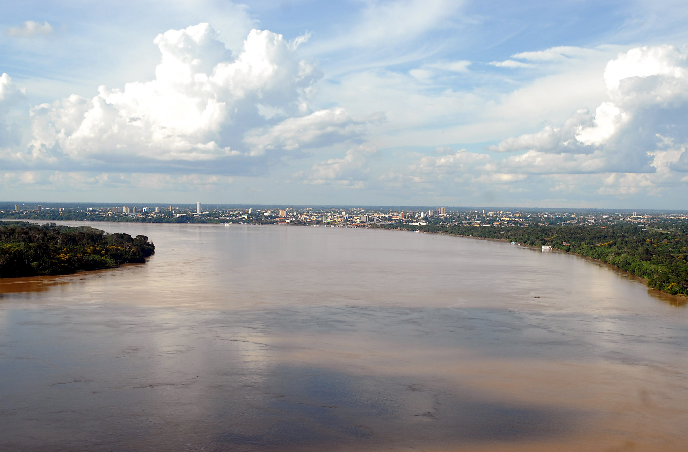
Rondônia (Brazil), North region (Amazon). Porto Velho is the capital of the state of Rondônia, in the southwest of the Brazilian Amazon, on the bank of the Madeira river, the main tributary of the Amazon. With around half a million inhabitants, it's the largest city in the state and the gateway to the western Amazon, close to the Bolivian border. Its history is marked by the legendary Madeira-Mamoré railway, the rubber cycle and, more recently, the big hydroelectric dams on the Madeira.
📌Service city
Porto Velho is itself the service city and the state capital. It has Governador Jorge Teixeira de Oliveira International Airport (PVH), with flights to Brasília, São Paulo, Manaus, Cuiabá and other cities. It's a junction on the BR-364 highway, which links it with Cuiabá and the Centre-West, and with Rio Branco (Acre) to the west. It has hotels, hospitals, universities, banks and an active river port on the Madeira. It's a base for seeing the Madeira-Mamoré heritage and for travel along the river and around the region.
📌Best time to go
The best time to visit Porto Velho and Rondônia is the dry season, roughly May/June to September/October, when there is less rain, the roads are in better condition and getting around the region is easier. The rainy season (November to April) brings heavy downpours, heat and humidity, and rises in the Madeira. The climate is equatorial, hot and humid all year, with high temperatures. Given the latitude, there are no great seasonal contrasts beyond the rainfall pattern.
📌Suggested days
Porto Velho is usually seen in 1 to 2 days, enough to take in the historic heritage tied to the Madeira-Mamoré railway: the railway complex and museum, the locomotives, the riverfront on the Madeira and the centre. With 3 to 4 days you can add trips around the area —cachoeiras, river bathing spots, the Santo Antônio and Jirau dams with their visitor side— or use the city as a stopover on a wider trip through the western Amazon or towards Bolivia.
💱 BRL exchange rate
Loading rate…
🌤️ Weather in Porto Velho
Loading weather…

Porto Velho is the capital of Rondônia and one of the big cities of the western Amazon, looking out over the imposing Madeira river, the largest tributary of the Amazon. It's a young, thriving city, born and grown in the heat of one of the most epic and tragic episodes in Brazilian history: the building of the Madeira-Mamoré railway, the 'devil's railway', a colossal undertaking raised in the middle of the jungle at the start of the 20th century at the cost of thousands of lives.

Today that history is the heart of its heritage: the old locomotives, the sheds and the railway museum, alongside the riverfront on the Madeira, tell the epic of rubber, of immigrants from half the world and of the struggle against the jungle. Porto Velho is also a frontier and transit city, a gateway to Bolivia, to Acre and to the Amazon interior, with the mixed energy of regions that grew fast in the heart of the forest.

This guide covers Porto Velho with a practical eye: what to see in the city and its surroundings, how to get there and get around, when to travel and how to use it as a base or a stopover on a trip through the western Amazon. It's not a destination of classic postcards, but anyone who knows how to look finds here one of the most fascinating stories of the conquest of the jungle and of daily life on the Madeira.

📖 History of Porto Velho

The Madeira river region was inhabited by various indigenous peoples long before the Europeans arrived. Porto Velho as a city was born at the start of the 20th century, inseparably tied to the building of the Madeira-Mamoré railway, the line raised to get around the cachoeiras (rapids) of the Madeira and allow Bolivian rubber and rubber from the western Amazon to reach the Atlantic. The work, taken up again by American businessmen between 1907 and 1912, drew thousands of workers from all over the world and cost an enormous number of lives to malaria, yellow fever and the brutal conditions of the jungle, earning it the nickname 'the devil's railway'. Around the railhead grew the settlement of Porto Velho ('old port'), which became a city. After the decline of rubber and, later, the closure of the railway, the region went through new economic cycles: mineral extraction (gold and tin/cassiterite), the migration driven by the opening of the BR-364 highway, which populated Rondônia, and the turning of Porto Velho into a state capital when the territory was raised to statehood in 1981. In the 21st century, the building of the big Santo Antônio and Jirau hydroelectric dams on the Madeira transformed the region again, amid heated environmental and social debate. The full story is on our history page.

Read the full history ↓

🏛️ Porto Velho is in Rondônia

The western Amazon state opened up in the twentieth century: land of rubber and of the Madeira-Mamoré 'devil's railway', which cost thousands of lives. It bears the name of Marshal Rondon, protector of Indigenous peoples, and it was the great destination of the state-directed Amazon colonization of the 1970s and 1980s.

Read the history of Rondônia →

🗺️ What to see

1
Madeira-Mamoré Railway Complex and Museum (EFMM)
The historic ensemble of the legendary 'devil's railway', with locomotives, sheds and a museum on the bank of the Madeira.
Porto Velho's great heritage treasure is the complex of the Estrada de Ferro Madeira-Mamoré (EFMM), the legendary 'devil's railway'. On the bank of the Madeira, where the head of the line stood, the ensemble of sheds, workshops, the old station and a park with steam locomotives and historic carriages is preserved, telling the epic of one of the most extreme and tragic engineering works in Brazilian history. The railway was built at the start of the 20th century (its definitive stretch was laid between 1907 and 1912) to get around the dozens of cachoeiras (rapids) that made the upper Madeira unnavigable, and so allow rubber from the western Amazon and from Bolivia to reach the Atlantic. The work drew thousands of workers from half the world and cost an enormous number of lives to malaria, yellow fever, accidents and the inhuman conditions of the jungle, earning it the nickname 'the devil's railway' or 'the railway of the dead'. The complex houses a railway museum displaying machines, tools, photographs and documents that tell this story, alongside the imposing restored locomotives. It's the perfect place to understand why Porto Velho exists and to learn about one of the most striking chapters of the rubber cycle. Getting there: it's in the riverfront/downtown area, on the Madeira; you can walk from the centre or take a taxi/app. Best time: any day; check the museum's opening times and any restoration work. Tips: combine the visit with a walk along the riverfront at dusk; ask whether tourist train rides are running.
ℹ️ Distance: Riverfront/downtown area of Porto Velho, on the Madeira (on foot or by taxi) · Best time to go: Any day; check the museum's opening times · Entry: Free; the Complexo reopened on 4 May 2024 after a major revitalization. You book a day and time at no cost through the Sympla system; there are guided and self-guided visits. Museum open Wednesday to Sunday (source: Prefeitura de Porto Velho, verified July 2026) · Duration: 1 to 2 hours
2
Riverfront (Orla) and the Madeira river
The waterfront promenade on the imposing Madeira, beside the railway heritage, ideal at sunset.
Porto Velho's riverfront (the Orla, in the area of the Espaço Alternativo and the railway complex) is one of the best places to feel the city's pulse and take in the imposing Madeira river, the main tributary of the Amazon. From here you watch the wide river run, the movement of boats and, on the bank, the remains and monuments of railway history. It's a pleasant walk, especially at dusk, when the sun drops over the river and the day's heat starts to ease. The area usually has green spaces, monuments, open-air locomotives and places where the people of Porto Velho spend their leisure time. The Madeira river, named for the huge amount of trunks and timber it drags along in its floods, is the great protagonist of the landscape. Nearby are Porto Velho's cathedral and the historic centre, with buildings that recall the era of the railway and of rubber. It's a good area to start exploring the city, combining history, river and local life. Getting there: right in the centre/riverside area; on foot or by taxi/app. Best time: dusk, for the light and cooler weather. Tips: combine it with the railway complex, which is right next door; bring sunscreen and water because of the heat; watch your belongings as in any urban area.
ℹ️ Distance: Centre/riverside area of Porto Velho (on foot or by taxi) · Best time to go: Dusk, for the light and the weather · Entry: Free (open access) · Duration: 1 to 2 hours
3
Sacred Heart of Jesus Cathedral and the historic centre
The main church and the old quarter of Porto Velho, with traces of the rubber and railway era.
Porto Velho's historic centre preserves the memory of the railway and rubber years. Its landmark is the Sacred Heart of Jesus Cathedral (Catedral de Porto Velho), a church of sober lines that presides over the city's religious life and is worth seeing along with the rest of the old quarter. Walking the centre you can see buildings and houses that recall the architecture of the early and mid 20th century, tied to the region's period of prosperity, as well as squares, markets and the lively commercial life of an Amazonian capital. The Mercado Cultural and the popular markets are good places to get to know regional food and produce. Porto Velho isn't a city of great colonial monuments —it's young, born in the 20th century— but its centre has the flavour of Amazonian cities that grew fast, with a mix of people from all over Brazil and the world. It's a good complement to the railway heritage and the river. Getting there: in the city centre; on foot or by taxi/app. Best time: by day, during business hours, when the centre is busy. Tips: combine it with the riverfront and the railway complex; take the chance to try local food in the markets.
ℹ️ Distance: Centre of Porto Velho (on foot) · Best time to go: By day, during business hours · Entry: Cathedral and squares free (open access); public museums with cheap or free entry (around R$ 0–10; verified July 2026) · Duration: Half a day
4
Cachoeira de Santo Antônio and the Madeira dams
The old rapids of the Madeira and the big Santo Antônio and Jirau hydroelectric plants, with their visitor side.
Upstream of Porto Velho, the Madeira historically presented a succession of cachoeiras (rapids) that made it unnavigable and that were, precisely, the whole reason for the Madeira-Mamoré railway. The most famous was the Cachoeira de Santo Antônio, tied to the origins of settlement in the area and to the history of the railway. In the 21st century, those rapids were transformed by the building of two big hydroelectric plants on the Madeira: Santo Antônio, very close to Porto Velho, and Jirau, further upstream. They are works on an enormous scale that completely changed the river's landscape and generated heated environmental and social debate over their impact on the forest, aquatic wildlife and local communities. Some of these plants have visitor centres or a visitor side where you can take in the scale of the work and how it functions. The Santo Antônio area is also of historical interest as one of the region's original settlement cores. Visiting it lets you understand the transformation of the Madeira over a century: from rapids that killed men and boats to today's gigantic dams. Getting there: a few kilometres from Porto Velho; by taxi/app, car or organized trip. Best time: dry season for better road conditions. Tips: check whether the plants offer visits and what they require; combine with river bathing spots in the area.
ℹ️ Distance: Near Porto Velho, upstream on the Madeira (car/organized trip) · Best time to go: Dry season (May to October) · Entry: Access to the historic area of Santo Antônio is free; visits to the plants (when offered) are usually free with a prior booking through their community relations programmes; guided trips around R$ 80–200 per person (verified July 2026) · Duration: Half a day
5
Bathing spots and cachoeiras around the city
The river swimming holes and waterfalls of the Porto Velho region, locals' refuge from the Amazon heat.
Like every Amazonian capital, Porto Velho and its surroundings offer several river bathing spots and cachoeiras (waterfalls) where locals and visitors go to cool off from the region's intense heat. These pockets of nature, spread along the igarapés (creeks) and rivers of the area, are the favourite weekend plan of the people of Porto Velho. Among the options there are usually bathing spots with swimming areas, kiosks and services, and more natural cachoeiras in rural Rondônia. Some are a short distance from the city and others require a longer drive across the region. The dry season is the best time to enjoy them, since the water is clearer and the roads in better condition. It's a good way to combine the historical visit to the city with a more relaxed contact with Amazonian nature, in a less touristy, more authentic setting than other Amazon destinations. Ask locally which ones are accessible and in good condition at the time. Getting there: by car, taxi/app or organized trip, depending on the spot. Best time: dry season (May to October). Tips: ask locals which bathing spots are best right now; bring cash, sunscreen, insect repellent and food or drink depending on the place.
ℹ️ Distance: Around Porto Velho and rural Rondônia (car/organized trip) · Best time to go: Dry season (May to October) · Entry: Many river bathing spots are free or cheap (around R$ 0–20 per person); some clubs/kiosks charge a minimum spend; verified July 2026 · Duration: Half a day to a full day
6
Markets and the Amazonian cooking of Rondônia
The regional flavour of Porto Velho: fish from the Madeira, Amazonian fruit and the mixed cooking of the frontier.
One of the best ways to get to know Porto Velho is through its food, the fruit of the mix of peoples who settled Rondônia: indigenous groups, northeasterners, southerners who came with the BR-364, bolivianos from over the border and migrants from all over Brazil. The markets and regional eating houses are the ideal place to dive into that blend of flavours. The great protagonist is fish from the Madeira and the Amazon: species such as tambaqui, tucunaré, pirarucu, dourado and jaraqui, grilled, fried, in caldeirada or in soup. You'll also find dishes with influences from across the region and Amazonian fruits such as cupuaçu, açaí and bacuri, in juices, ice creams and sweets. The popular markets and the Mercado Cultural let you see and taste local produce, and are a window onto daily life in this frontier city. Pairing good fish with a caipirinha or an Amazonian fruit juice, looking out at the river, is a perfect way to end the day. Getting there: markets and restaurants in the centre and the riverside area; on foot or by taxi/app. Best time: any day; the markets are busiest in the morning. Tips: try the regional fish and the Amazonian fruit juices; check the markets' opening times.
ℹ️ Distance: Centre and riverside area of Porto Velho (on foot or by taxi) · Best time to go: Any day; markets busiest in the morning · Entry: Free access to the markets; food and drink extra · Duration: 1 to 2 hours
Advertisements
What nobody tells you

💵 Prices

Tickets

TypePrice
Madeira-Mamoré Railway Complex and MuseumFree; the Complexo reopened in May 2024 after its revitalization. You book a day and time at no cost through Sympla; guided and self-guided visits (source: Prefeitura de Porto Velho, verified July 2026)
Riverfront (Orla) and the Madeira riverFree (open access)
Cathedral and downtown squaresFree (open access)
Visit to the Santo Antônio area / hydroelectric plantsFree access to the historic area; visits to the plants (when offered) free with a prior booking; guided trips around R$ 80–200 per person (verified July 2026)
Bathing spots and cachoeiras around the cityMany free or cheap (around R$ 0–20 per person); some clubs/kiosks charge a minimum spend (verified July 2026)
Markets and foodFree access; food and drink extra
🔄 updated monthlyOfficial / reference values · double-check when buying

Activities and tours

ActivityPriceDurationOperator
Visit to the Madeira-Mamoré complex and museumFree (booking at no cost through Sympla, verified July 2026)1-2 hComplexo da Estrada de Ferro Madeira-Mamoré (Prefeitura de Porto Velho)
Historic city tour of Porto VelhoAround R$ 80–180 per person depending on the operator (verified July 2026)Half a dayLocal agencies and guides
Trip to the Santo Antônio area and the damsAround R$ 80–200 per person depending on the operator (verified July 2026)Half a dayLocal agencies
Boat trip on the Madeira riverAround R$ 40–120 per person depending on the trip and its length (verified July 2026)VariesBoatmen and operators at the Complexo Madeira-Mamoré
A day at a bathing spot / cachoeira nearbyAccess around R$ 0–20 per person; transport on an organized trip around R$ 50–150 (verified July 2026)Half a day to a full dayYour own transport or an organized trip
🔄 updated monthlyOfficial / reference values · double-check when buying
Advertisements

🚌 How to get there and distances

Getting around

ModePriceDurationNotes
Taxi and apps (Uber, 99)City trips around R$ 12–30; to the airport around R$ 40–60 (verified July 2026)VariesThe most comfortable way to get around the city, to the airport and to the surroundings; recommended at night
City busFare around R$ 4,40–5 (verified July 2026)VariesA network of city buses; cheap, but at night a taxi/app is preferable; buses to the airport usually run once an hour
Car rentalAround R$ 120–250 a day depending on category (verified July 2026), plus fuelVariesUseful for touring the surroundings, the dams and bathing spots, and for trips along the BR-364 to other cities
MototaxiShort trips around R$ 8–20 (verified July 2026)VariesCommon in the region for short trips; cheap
River boat (Madeira river)Short trips around R$ 40–120 per person; scheduled crossings to Manaus vary by destination and class (hammock/cabin); verified July 2026VariesFor trips and crossings along the Madeira; scheduled boats connect with other Amazon points
🔄 updated monthlyOfficial / reference values · double-check when buying

How to get there

RouteAirlines / operatorsAvg. priceDuration
Flight to Porto Velho (PVH airport) from Brasília, São Paulo, Manaus, CuiabáLATAM, GOL, AzulBrasília–Porto Velho return from around R$ 720; usually R$ 900–2.000 depending on how far ahead you book and the season (verified July 2026)Depends on the origin (Brasília about 2 h 30)
PVH airport → centre of Porto VelhoTaxis, apps and busesTaxi/app around R$ 40–60; city bus around R$ 4,40–5 (verified July 2026)About 20 to 30 min
By the BR-364 from Cuiabá (Mato Grosso) or Rio Branco (Acre)Eucatur, Rondônia and other bus companies; your own vehicleCuiabá–Porto Velho bus around R$ 350–550; Rio Branco–Porto Velho around R$ 120–220 (verified July 2026)Long distances across the Amazon (Cuiabá ~24 h; Rio Branco ~8 h)
River crossing / connection along the MadeiraAmazon shipping companiesPorto Velho–Manaus on a regional boat around R$ 250–500 in a hammock, more in a cabin (verified July 2026); several days of travelDepends on the destination (to Manaus, 3 to 4 days)
🔄 updated monthlyOfficial / reference values · double-check when buying

🏨 Where to stay

No exact prices: a scale from $ (budget) to $$$$$ (luxury), with 2-3 options per category.

CategoryPriceRecommended options
Business hotels / upper category$$$$$Hotels aimed at business travellers downtown and nearby (e.g. Intercity, Larick Hotel): around R$ 280–500 a night (verified July 2026), with good facilities
Mid-range hotels downtown$$$$$A good choice of mid-range hotels downtown, near the railway heritage and the riverfront: around R$ 180–320 a night (verified July 2026)
Budget hotels and pousadas$$$$$Cheap options and pousadas for travellers passing through and backpackers: around R$ 100–180 a night (verified July 2026)
Lodging near the airport / highways$$$$$Practical places to stay for anyone arriving or leaving by air or on the BR-364: around R$ 150–300 a night (verified July 2026)

🍴 Where to eat

TypePriceOptions / signature dish
Fish from the Madeira (tambaqui, tucunaré, pirarucu, dourado)$$$$$Restaurants specializing in river fish, grilled, fried or in caldeirada (e.g. Caravela do Madeira, Peixaria Cabôca): around R$ 60–140 a dish; a whole fish to share R$ 100–200 (verified July 2026)
The mixed cooking of Rondônia and the frontier$$$$$Places with dishes that reflect the mix of peoples (northeasterners, southerners, Bolivians, indigenous groups): around R$ 35–90 a dish (verified July 2026)
Popular markets and cheap regional food$$$$$Markets and lanchonetes for eating cheaply and trying Amazonian fruit and juices: around R$ 15–40 per person (verified July 2026)
Bars and kiosks on the riverfront$$$$$Bars and kiosks beside the Madeira for petiscos and drinks at dusk: sharing plates around R$ 35–80; beer/drink R$ 8–18 (verified July 2026)
Advertisements

📖 History of Porto Velho

Origins, formation and what the sources say.

The Madeira river and the original peoples

The history of Porto Velho is inseparable from the Madeira river, the largest tributary of the Amazon and one of the highest-volume rivers in the world. Its name, 'Madeira' (timber, in Portuguese), refers to the huge quantity of trunks and vegetation the river drags along during its floods. Its water, loaded with Andean sediment, makes it a 'white water' river, very different from black-water rivers such as the Rio Negro.

Long before the Europeans arrived, the Madeira basin was inhabited by numerous indigenous peoples, belonging to different language families, who lived from fishing, hunting, gathering and farming along the banks and tributaries of the river. The region, in the southwest of the Amazon, was a territory of great natural wealth and complex settlement networks, part of which survives today in the indigenous lands of Rondônia.

The upper course of the Madeira presented a decisive natural obstacle to navigation: a long succession of cachoeiras (rapids and falls) that made it impossible to go upriver by boat beyond a certain point. That geographical feature, which for centuries limited penetration and trade, would be precisely the reason that gave rise, at the start of the 20th century, to one of the most epic undertakings in Brazilian history and to the city of Porto Velho itself.

The origin of the name of the Madeira river
The most widespread explanation attributes the name of the Madeira river to the great quantity of trunks and timber it drags along in its floods, especially visible at certain times of year. It's a white-water river because of the Andean sediment it carries. The finer points about the origin of the place name can vary between sources.
Source: https://es.wikipedia.org/wiki/R%C3%ADo_Madeira

The Madeira-Mamoré railway: the 'devil's railway' (1907–1912)

The birth of Porto Velho is inseparably tied to one of the most tragic epics in the history of engineering: the building of the Estrada de Ferro Madeira-Mamoré (EFMM). The aim of the work was to bypass by land the dozens of cachoeiras that made the upper Madeira unnavigable, so that rubber produced in the western Amazon and, above all, in Bolivia could reach the Atlantic. The question had a geopolitical dimension: after Bolivia ceded Acre to Brazil (Treaty of Petrópolis, 1903), Brazil undertook to build the railway as compensation, to give Bolivia an outlet for its goods.

The definitive construction of the railway was carried out between 1907 and 1912, led by American businessmen and engineers. The work drew a veritable Babel of workers: thousands of men of dozens of nationalities —Caribbean, European, Asian, Brazilians from every region— came to the jungle to lay the rails. Conditions were hellish: malaria, yellow fever, dysentery, accidents and the merciless climate killed an enormous number of workers. The popular legend —which says there was 'one dead man for every sleeper' of the track— exaggerates the figures, but reflects the scale of the tragedy that earned the railway the nickname 'the devil's railway' or 'the railway of the dead'.

Around the head of the railway, on the Madeira, a camp grew that turned into a settlement and then a city: Porto Velho ('old port'). The historical irony is that, by the time the railway was completed in 1912, the Amazon rubber cycle was already deep in crisis, brought down by competition from the plantations of Southeast Asia. The work that had cost so many lives was born, to a large extent, obsolete.

The death toll and the legend of the 'sleeper'
The famous line about 'one dead man for every sleeper' of the railway is a popular exaggeration. Historians estimate thousands of deaths during construction, but the exact figures vary widely depending on the source and the periods considered (there were earlier attempts at the work in the 19th century). What is beyond dispute is that mortality was extremely high because of tropical disease and working conditions.
Source: https://es.wikipedia.org/wiki/Ferrocarril_Madeira-Mamor%C3%A9
The Treaty of Petrópolis and the geopolitical origin
The commitment to build the Madeira-Mamoré is linked to the Treaty of Petrópolis (1903), by which Bolivia ceded Acre to Brazil in exchange, among other things, for the building of a railway that would give its goods an outlet past the cachoeiras of the Madeira. The details of the clauses and how they were honoured are a matter for historical study.
Source: https://en.wikipedia.org/wiki/Madeira-Mamor%C3%A9_Railroad

From the rubber boom to the closing of the railway

Once completed in 1912, the Madeira-Mamoré railway ran for several decades, but it never met the economic expectations that had justified building it, largely because the collapse of Amazon rubber had ruined its whole reason for existing. Even so, Porto Velho, born as its railhead, established itself as an urban centre and the hub of the Madeira region.

Through the first half of the 20th century, the city and its surroundings lived to the rhythm of the ups and downs of the Amazon economy. There was a brief rubber revival during the Second World War —when the Allies, cut off from Asian rubber occupied by Japan, pushed Amazon extraction again with the so-called 'rubber soldiers'— which partly reactivated the region and the railway. But once the war was over, decline returned.

The Madeira-Mamoré railway was finally shut down and closed in the 1960s-1970s, ending more than half a century of history. Its locomotives, sheds and stations, far from disappearing entirely, remained as testimony to that epic and are today Porto Velho's main historic heritage, turned into a complex and museum. The memory of the 'devil's railway' is still the soul of the city's identity.

The 'rubber soldiers' and the Second World War
During the Second World War, with Southeast Asia under Japanese occupation, the Allies pushed a new round of rubber extraction in the Amazon, recruiting thousands of workers from northeastern Brazil (the 'soldados da borracha'). This temporarily reactivated the Madeira region. The scale and the social consequences of this episode are a matter for historical study.
Source: https://pt.wikipedia.org/wiki/Soldados_da_borracha

The BR-364, migration and Rondônia as a state (1981)

The great transformation of Porto Velho and of the whole region came in the second half of the 20th century with integration by land. The opening and, later, the paving of the BR-364 highway, which links Porto Velho with Cuiabá and the Centre-West, unleashed a process of colonization and mass migration into the former Federal Territory of Rondônia, driven by policies to occupy the Amazon and by the promise of land.

Between the 1970s and 1980s, hundreds of thousands of migrants —especially from the south and southeast of Brazil— arrived along the BR-364 looking for land and opportunity, in one of the fastest settlement processes in the Amazon. That migration multiplied the population, transformed the landscape (with farming and cattle advancing into the forest) and gave Porto Velho and Rondônia their characteristic mix of people from all over the country, alongside the indigenous peoples and the Bolivians of the border.

That growth led to political and administrative reorganization: in 1981, the Federal Territory of Rondônia was raised to the status of a state of the Brazilian federation, and Porto Velho became its capital. Rapid colonization brought development, but also serious problems: deforestation, land conflicts, pressure on indigenous peoples and speculation. Porto Velho thus consolidated its role as the capital of a young, dynamic state shot through with the tensions typical of the Amazon frontier.

The BR-364 and the colonization of Rondônia
Sources agree that the opening and paving of the BR-364 drove mass migration into Rondônia between the 1970s and 1980s, with rapid population growth and a sharp advance in deforestation. The environmental and social impact of this process, financed in part with international support, is widely debated.
Source: https://en.wikipedia.org/wiki/Rond%C3%B4nia

The Madeira dams and the contemporary environmental debate

In the 21st century, a new cycle transformed the river and the region once again: the building of big hydroelectric plants on the Madeira. The Santo Antônio dam, very close to Porto Velho, and the Jirau dam, further upstream, were raised to generate power on a large scale as part of Brazil's electricity expansion plans. The works, on an enormous scale, completely altered the regime of a river that for centuries had been defined by its cachoeiras.

Building these mega-dams in the middle of the Amazon generated —and still generates— heated environmental and social debate. Among the concerns are the impact on aquatic wildlife (especially fish migration, the basis of the riverside economy and diet), the flooding of land, the effects on displaced communities, indigenous peoples and traditional populations, and the changes in the river's dynamics. The arrival of works on that scale also caused sharp population and urban growth in Porto Velho.

So the history of Porto Velho traces a fascinating arc: from the cachoeiras that killed men and justified the 'devil's railway' to the gigantic dams that tamed them a century later. The city embodies, as few do, the successive cycles of the conquest and transformation of the Amazon —rubber, the railway, migration, mining, the dams— with everything they hold of epic, of progress and of conflict. Today Porto Velho looks to the future between development and the challenge of preserving the forest around it.

The impact of the Santo Antônio and Jirau dams
Sources agree that the Santo Antônio and Jirau plants, built in the 21st century on the Madeira river, transformed the river and the region, and generated debate over their environmental and social impact (fish migration, displaced communities, indigenous peoples). Weighing the costs against the benefits remains a matter of controversy between the energy sector, environmentalists and the affected populations.
Source: https://en.wikipedia.org/wiki/Santo_Ant%C3%B4nio_Dam

📚 Bibliography

  • Wikipedia (ES) — «Porto Velho»: https://es.wikipedia.org/wiki/Porto_Velho
  • Wikipedia (EN) — «Porto Velho»: https://en.wikipedia.org/wiki/Porto_Velho
  • Wikipedia (PT) — «Porto Velho»: https://pt.wikipedia.org/wiki/Porto_Velho
  • Wikipedia (ES) — «Ferrocarril Madeira-Mamoré»: https://es.wikipedia.org/wiki/Ferrocarril_Madeira-Mamor%C3%A9
  • Wikipedia (EN) — «Madeira-Mamoré Railroad»: https://en.wikipedia.org/wiki/Madeira-Mamor%C3%A9_Railroad
  • Wikipedia (ES) — «Río Madeira»: https://es.wikipedia.org/wiki/R%C3%ADo_Madeira
  • Wikipedia (EN) — «Rondônia»: https://en.wikipedia.org/wiki/Rond%C3%B4nia
  • Wikipedia (PT) — «Soldados da borracha»: https://pt.wikipedia.org/wiki/Soldados_da_borracha
  • Wikipedia (EN) — «Santo Antônio Dam»: https://en.wikipedia.org/wiki/Santo_Ant%C3%B4nio_Dam
  • Wikipedia (EN) — «Jirau Dam»: https://en.wikipedia.org/wiki/Jirau_Dam

❓ Frequently asked questions

What is there to see in Porto Velho?+
The unmissable one is the Madeira-Mamoré railway complex and museum, the legendary 'devil's railway', with its locomotives and its tragic story from the rubber cycle. It goes together with the riverfront on the Madeira, the historic centre with the cathedral, the dams and the Santo Antônio area, and the bathing spots and cachoeiras nearby.
What's the best time to visit?+
The dry season, roughly May/June to September/October, is the best: less rain, roads in better condition and easier going around the city and its surroundings. The rainy season (November to April) brings heavy downpours, heat and humidity. The climate is hot and humid all year.
How many days do I need in Porto Velho?+
In 1 to 2 days you can see the historic heritage (the Madeira-Mamoré, the riverfront, the centre). With 3 to 4 days you can add the dams, the Santo Antônio area and the bathing spots and cachoeiras nearby, or use the city as a stopover on a wider trip through the western Amazon or towards Bolivia.
What was the Madeira-Mamoré railway?+
It was a railway built at the start of the 20th century (its definitive stretch between 1907 and 1912) to get around the cachoeiras of the Madeira and allow rubber from the western Amazon and from Bolivia to reach the Atlantic. The work drew thousands of workers and cost an enormous number of lives to malaria and the extreme conditions of the jungle, which is why it's known as the 'devil's railway'. Porto Velho grew up around its railhead.
Is it safe to travel to Porto Velho?+
Porto Velho is a frontier city with the dynamics of Amazonian capitals; take the usual precautions: watch your belongings, don't carry much cash in view, avoid quiet areas at night and use a taxi/app to get around. The central and tourist areas by day are fine with common sense.
What do you eat in Porto Velho?+
The star is fish from the Madeira and the Amazon (tambaqui, tucunaré, pirarucu, dourado, jaraqui), grilled, fried or in caldeirada. The cooking reflects the mix of peoples who settled Rondônia, and comes with Amazonian fruits such as cupuaçu, açaí and bacuri in juices and sweets. The markets are ideal for trying all of it.
Does Porto Velho work as a base or a stopover?+
Yes. It's a transport hub for the western Amazon: an airport with flights to several capitals and the BR-364 highway linking it with Cuiabá and the Centre-West on one side and with Rio Branco (Acre) on the other, close to the Bolivian border. It's a common stopover on trips through the western Amazon.
Sources consulted (10)
Still planning?
Explore more destinations in Brazil
See all destinations →
Advertisements
Image credits
Photos from Wikimedia Commons, each under its own licence (CC BY, CC BY-SA or public domain). Open each file to see its author and licence.
Portovelho11062007