Viajá con Gus
HomeBrazilPalmas
Palmas
🇧🇷 Brazil · North

Palmas

Jump to what you need
📌State
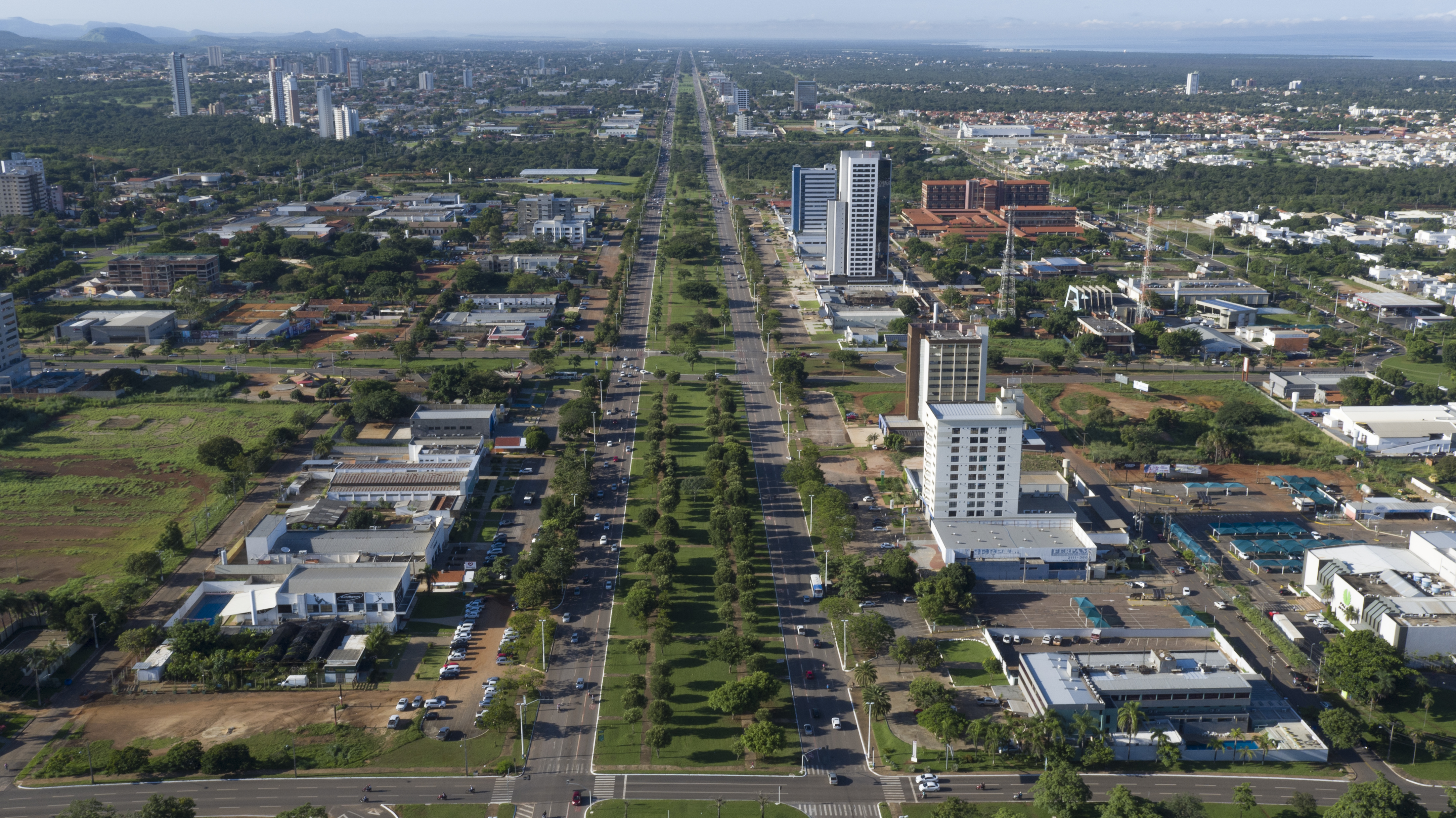
Palmas is the capital of the state of Tocantins, in the North region of Brazil. It's the youngest state capital in the country: it was planned and founded in 1989, after the creation of the state of Tocantins (split off from Goiás). It sits on the banks of the Tocantins river, on the large lake of the Luís Eduardo Magalhães hydroelectric dam. It's a planned city, with wide avenues and blocks (the 'quadras') ordered by a coordinate system, in a transition zone between the cerrado and the Amazon
📌Service city
Palmas itself holds the services. It has an airport (Aeroporto de Palmas–Brigadeiro Lysias Rodrigues, PMW), with flights to Brasília, São Paulo, Goiânia and other capitals; a long-distance bus terminal; hotels, hospitals, universities and shopping centres. It's the most convenient service base for organising a trip to the Jalapão, the great ecotourism destination of Tocantins, although going deep into the Jalapão starts from Mateiros and nearby villages
📌Best time to go
The climate is tropical, warm all year, with two clearly marked seasons. The dry season (May to September/October) is the best time to visit: clear skies, dry heat, rivers and roads in good shape, ideal for combining with the Jalapão (whose best season coincides). The rainy season (November to April) brings humid heat, afternoon storms and dirt roads that can turn tricky. The heat is intense almost all year, so drink plenty and protect yourself from the sun
📌Suggested days
One or two days are enough for the city itself: the Palácio Araguaia and the Praça dos Girassóis, the freshwater beaches on the lake (Praia da Graciosa), the viewpoints and the planned architecture. The usual thing is to use Palmas as a gateway and pair it with a 3 to 5 day expedition to the Jalapão, which adds up to roughly a week. If you only want the city and its river beaches, a weekend is enough
💱 BRL exchange rate
Loading rate…
🌤️ Weather in Palmas
Loading weather…

Palmas is an oddity within Brazil: a state capital entirely planned and built from scratch in the late 20th century. Founded in 1989 when the state of Tocantins was created, it's the youngest capital in the country, a city of extremely wide avenues, blocks ordered by coordinates and a lot of open sky, raised on the banks of the Tocantins river, beside an enormous artificial lake. Its modern, geometric layout recalls, on a smaller scale, the planning spirit of Brasília.

But beyond its curious urban design, what puts Palmas on the traveller's map is its role as the gateway to the Jalapão, one of Brazil's great ecotourism destinations: a landscape of orange dunes, fervedouros of crystal-clear water, waterfalls and wild cerrado. Palmas is the logical base for flying in, stocking up and organising the expedition to that remote corner of the country.

The city also has its own quiet charm: freshwater beaches on the lake, wide sunsets over the water, regional cooking with river fish and the gentle heat of the interior. This guide covers the practical side of Palmas —how to get there, what to see, where to sleep and eat— treating it both as a destination in itself and as a springboard to the Jalapão.

📖 History of Palmas

Palmas is the youngest state capital in Brazil. It was born with the creation of the state of Tocantins, which the 1988 Constitution split off from northern Goiás to give autonomy to a historically neglected region. Since no existing city met the conditions to be the capital, the decision was made to build a new, planned one on a site chosen on the banks of the Tocantins river. The foundation stone was laid in 1989 and the city grew very fast in the following decades, with a modern layout of wide avenues and numbered blocks. Its name evokes the old district of São João da Palma, tied to the history of the region. Before it was founded, the territory of today's Tocantins had a long history linked to the 18th-century gold cycle (with settlements such as Natividade and Monte do Carmo) and to the struggle for the separation of northern Goiás. Today Palmas combines its character as a planned capital with its role as the gateway to the Jalapão. The full story is on our history page.

Read the full history ↓

🏛️ Palmas is in Tocantins

The youngest state in Brazil, created in 1988: the former northern half of Goiás, settled by gold-seeking bandeirantes and carrying a long dream of autonomy that goes back to 1821. A land of Cerrado between two great rivers, with the planned capital of Palmas and the dunes, waterfalls and crystalline waters of Jalapão.

Read the history of Tocantins →

🗺️ What to see

1
Praça dos Girassóis and Palácio Araguaia
The civic heart of Palmas: one of the largest urban squares in Brazil, with the seat of government and monuments.
The Praça dos Girassóis is the symbolic and geographic centre of Palmas and one of the largest urban squares in Brazil, with an enormous footprint suited to a planned capital. Around it are the buildings of state power in Tocantins, starting with the Palácio Araguaia, the seat of the state government, modern and monumental in style. The square is dotted with monuments and works that tell the identity of Tocantins: the Monumento aos Dezoito do Forte de Copacabana, the sundial (one of the largest in the world), the Memorial Coluna Prestes and references to the struggle to create the state. Its scale, its gardens and its esplanade make it a good place to start understanding the planned spirit of the city. It's an easy walk, though the heat is worth bearing in mind: the best times are first thing in the morning or at sunset. For its scale and its symbolism, it's the civic postcard of Palmas and a point of orientation within the city's layout. Getting there: it's in the centre of Palmas, reachable by car, taxi/app or on foot from the central hotels. Best time: early or at sunset because of the heat. Tips: bring sunscreen, water and a hat; pair it with a visit to the museums and monuments around it and ask whether there are tours or events at the Palácio.
ℹ️ Distance: Central Palmas (on foot, taxi/app or car) · Best time: Early morning or at sunset (because of the heat) · Admission: Free (public space) · Duration: 1 to 2 hours
2
Praia da Graciosa (freshwater beach on the lake)
The most popular urban beach in Palmas, pale sand and fresh water on the great lake of the Tocantins river.
One of the big surprises of Palmas is that, despite being deep inland, it has beaches. The hydroelectric dam that holds back the Tocantins river formed an enormous freshwater lake beside the city, and urban beaches of pale sand were laid out along its shores, the Praia da Graciosa being the best known and busiest. The Graciosa is a leisure spot with sand, calm water for swimming, kiosks, bars and restaurants, packed with locals at weekends and in the dry season. It's where the city goes to cool off from the heat, have a drink, listen to music and enjoy the sunsets over the water, which are wide and very photogenic. Around the lake there are other beaches and swimming spots, and you can pair the visit with boat trips or water sports. It's an ideal plan to add to a stay in the city, above all to rest between the long drives to or from the Jalapão. Getting there: it's in the lake area, a few minutes by car or taxi/app from central Palmas. Best time: dry season, and especially sunset. Tips: bring small notes for the kiosks, sunscreen and insect repellent; check the state of the water and the beach depending on the season (the lake level varies).
ℹ️ Distance: Lakeshore, a few minutes from the centre (car or taxi/app) · Best time: Dry season; sunsets over the lake · Admission: Free (public beach); food and drink at the kiosks (fish portions R$ 40–90, beer R$ 8–15, verified July 2026) · Duration: Half a day
3
Gateway to the Jalapão
Palmas as the base for the great Jalapão expedition: dunes, fervedouros and waterfalls of the Tocantins cerrado.
The main reason many travellers come to Palmas is the Jalapão, one of the most impressive ecotourism destinations in Brazil. Palmas works as the gateway: it's where you land, book the expeditions, stock up and put together the trip to that vast cerrado landscape in the east of the state. The Jalapão is famous for its orange sand dunes in the middle of the green, its fervedouros (pools of crystal-clear water and springs where the upward push of the water keeps you from sinking), its waterfalls (such as the Cachoeira da Velha) and its clear rivers perfect for floating. It's a remote destination of dirt roads and long distances, so it's almost always visited on organised 4x4 expeditions setting out from Palmas or from villages such as Ponte Alta do Tocantins and Mateiros. The expeditions usually last 3 to 5 days and include transport, rustic accommodation and a guide. Because of the remoteness, the logistics and the state of the roads, it's strongly advisable to book with specialist operators and not head off on your own without experience. (The Jalapão has its own guide on this site.) Getting there: from Palmas on an organised 4x4 expedition to the Jalapão (several hours on the road). Best time: dry season (May to September/October). Tips: book the expedition ahead, carry cash (in the interior there may be no signal or ATMs), light clothing, strong sun protection and footwear for sand and water.
ℹ️ Distance: The Jalapão lies east of Palmas; several hours on dirt roads (4x4 expedition) · Best time: Dry season (May to September/October) · Admission: Organised 4x4 expedition: R$ 3,118 per person on normal dates and R$ 3,353 on public holidays (4 days departing from Palmas, with 3 nights' accommodation, full board, fees, guide and insurance; source: operator Desviantes, verified July 2026) · Duration: 3 to 5 days (expedition)
4
Viewpoints and the city's planned architecture
Taking in the singular urban design of Palmas: avenues, numbered quadras and viewpoints over the lake and the sierra.
Palmas is, in itself, an object of urban curiosity. As a capital planned and built from scratch in 1989, its layout is organised with wide avenues and a system of blocks (the 'quadras') identified by coordinates, something that surprises and, at first, disorients visitors. Getting around the city means understanding a form of modern planning in the Brazilian interior, heir to the spirit of Brasília. The city has a few viewpoints and high spots from which to take in its extent, the lake of the Tocantins river and, in the background, the Serra do Lajeado, which frames Palmas to the east. Those spots are good for sunset and for grasping the scale of the city in the middle of the cerrado. It's also worth walking the avenues, the parks and the public spaces that structure the city. Among the urban points of interest are the Praça dos Girassóis itself, the memorials, the government buildings and some cultural venues. It's a calm route, ideal to do by car given the long internal distances and the heat. Getting there: by car or taxi/app, given the scale of the city and the distances between points. Best time: sunset for the viewpoints; morning for getting around with less heat. Tips: keep the coordinate system in mind to orient yourself; use GPS, stay hydrated and protect yourself from the sun.
ℹ️ Distance: Within the city; long distances (car or taxi/app recommended) · Best time: Sunset for viewpoints; morning for getting around · Admission: Free (public spaces) · Duration: Half a day
5
Serra do Lajeado and waterfalls nearby
The range that frames Palmas, with waterfalls, freshwater swimming spots and cerrado trails close by.
East of Palmas rises the Serra do Lajeado, part of the Parque Estadual do Lajeado, which offers nature and a cool-off very close to the city. The area, in and around the range, hides waterfalls, freshwater swimming spots and cerrado trails, an alternative for those who don't make it out to the distant Jalapão but want contact with the nature of Tocantins. Around here there are several swimming spots in rivers and waterfalls, some fitted out with kiosks and rest areas, popular with locals in the dry season and on hot weekends. They're places to cool off, take a short walk and enjoy the cerrado landscape, with its characteristic vegetation. The range also gives panoramic views over the city and the lake, and makes a good half-day plan. Ask locally which swimming spots and waterfalls are open and in good condition depending on the season, since the flow depends on the rains. Getting there: by car or on a tour, towards the Serra do Lajeado and the swimming spots near Palmas. Best time: dry season for the roads; the waterfall flows are best towards the end of the rainy season. Tips: check access and whether the spots are open, bring suitable footwear, water, insect repellent and small notes.
ℹ️ Distance: Serra do Lajeado and surroundings, east of Palmas (car or tour) · Best time: Dry season for access; flows are better at the end of the rains · Admission: Free access or a fee depending on the spot (approx. R$ 10–40 per person at the private ones, verified July 2026) · Duration: Half a day
6
Parque Cesamar
The great urban park of Palmas: a reserve with a lake, artificial waterfalls, cerrado wildlife and trails, right in the middle of the city.
The Parque Cesamar, created in 1998, is the main urban park in Palmas and one of the public spaces locals love most. Across its nearly 97,000 m² of reserve it works as a genuine green lung in the middle of the planned city: it holds a lake in the Brejo Comprido stream basin, artificial waterfalls, shaded trails and abundant cerrado wildlife living free or semi-free —macaws, parrots, monkeys, capybaras, armadillos— which makes it ideal for a quiet walk or a family outing. The park has a walking and running track, sports and skate areas, restaurants and the Casa Saçuapara, the former seat of the first city hall of Palmas, today a small museum. There are pedalinho (pedal boat) rides on the lake. It's one of the best free plans in the city, above all early in the morning or at sunset, when the heat eases and the wildlife is more active.
ℹ️ Distance: In the Plano Diretor Sul, within the city (car or taxi/app) · Opening hours: Daily, generally from 5:00/6:00 a.m. to 11 p.m. (source: Prefeitura de Palmas and Turismo Tocantins, verified July 2026) · Admission: Free (open access); pedalinho for a small charge (~R$ 10–20 per ride, verified July 2026) · Duration: 1 to 3 hours
Advertisements
What nobody tells you

💵 Prices

Tickets

TypePrice
Praça dos Girassóis and Palácio Araguaia (exterior)Free (public space)
Praia da GraciosaFree (public beach); food and drink at the kiosks: fish portions R$ 40–90, beer R$ 8–15 (verified July 2026)
Parque CesamarFree (open access); pedalinho for a small charge (~R$ 10–20, verified July 2026)
Jalapão expedition (4 days, from Palmas)R$ 3,118 per person on normal dates / R$ 3,353 on public holidays (includes 4x4, 3 nights' accommodation, full board, fees, guide and insurance; source: operator Desviantes, verified July 2026)
Swimming spots and waterfalls of the Serra do LajeadoFree access or a fee depending on the spot (approx. R$ 10–40 per person at the private ones, verified July 2026)
Viewpoints and city walksFree (public spaces)
🔄 updated monthlyOfficial / reference values · double-check when buying

Activities and tours

ActivityPriceDurationOperator
4x4 expedition to the Jalapão (dunes, fervedouros, waterfalls)R$ 3,118–3,353 per person (4 days, all in; source: Desviantes, verified July 2026)3 to 5 daysEcotourism operators in Palmas and the Jalapão (Desviantes, Jalapão Expedições, TataTur, etc.)
Beach day and sunset at the Praia da GraciosaFree (food and drink on top)Half a day
City tour of planned Palmas (square, monuments, viewpoints)Approx. R$ 100–250 per person (verified July 2026)Half a dayLocal guides and agencies
Boat trip / water sports on the Tocantins lakeApprox. R$ 50–150 per person (verified July 2026)1-3 hWater sports operators on the lake
Waterfalls and swimming spots of the Serra do LajeadoR$ 10–40 per person (admission to private spots); guided tour R$ 100–250 (verified July 2026)Half a dayLocal tours
🔄 updated monthlyOfficial / reference values · double-check when buying
Advertisements

🚌 How to get there and distances

Getting around

ModePriceDurationNotes
Taxi and apps (Uber, 99)UberX within the city R$ 10–30; airport → centre ~R$ 30–40 (taxi ~R$ 70), verified July 2026VariesThe most convenient way to move around a city of long distances and widely spaced blocks, above all in the heat
Rental carApprox. R$ 120–250 a day (verified July 2026); 4x4 costs moreVariesVery practical given the scale of Palmas and for reaching the lake beaches and the Serra do Lajeado. A 4x4 is advisable if you plan to enter the Jalapão on your own (not recommended without experience)
City bus~R$ 4–5 a ride (verified July 2026)VariesMunicipal bus network; cheap, but the long distances and the heat mean many visitors prefer taxi/app or a car
🔄 updated monthlyOfficial / reference values · double-check when buying

How to get there

RouteAirlines / operatorsAvg. priceDuration
Flights to Palmas (PMW) from Brasília, São Paulo, Goiânia, etc.LATAM, GOL, AzulAirfare varies with origin and how far ahead you bookDepends on origin
Palmas airport (PMW) → centre / hotelsTaxis/apps (Uber, 99) and transfersUber ~R$ 30–40; taxi ~R$ 70 (verified July 2026; the airport is ~18 km from the centre)~20-30 minutes
Arriving by long-distance bus (Terminal Rodoviário de Palmas)National bus companiesVaries with origin (e.g. from Brasília or Goiânia, approx. R$ 150–300, verified July 2026)Depends on origin (Brasília, Goiânia, Belém, etc.)
Palmas → Jalapão (Ponte Alta, Mateiros)Organised 4x4 expeditionsIncluded in the expedition package (R$ 3,118–3,353 for 4 days, verified July 2026)Several hours on dirt roads
🔄 updated monthlyOfficial / reference values · double-check when buying

🏨 Where to stay

No exact prices: a scale from $ (budget) to $$$$$ (luxury), with 2-3 options per category.

CategoryPriceRecommended options
Business hotels / upper-mid range$$$$$Approx. R$ 300–500 a night (verified July 2026). E.g.: Vivence Suítes, Pousada Aldeia da Serra (from ~R$ 344). Hotels geared to business travel and to government work, with a pool, sauna and a central location. Comfortable as a base before or after the Jalapão
Mid-range hotels in the centre$$$$$Approx. R$ 200–300 a night (verified July 2026). E.g.: Pousada dos Girassóis (from ~R$ 210), Hotel Palmas Tocantins. Plenty of choice in the central quadras, practical for getting around the city and reaching the airport and the bus terminal
Budget / hostels and guesthouses$$$$$Approx. R$ 85–150 a night (verified July 2026). E.g.: Pousada Braga (from ~R$ 125). Guesthouses and cheap options for travellers on a tight budget, many of them passing through on the way to the Jalapão
Rustic accommodation in the Jalapão (expedition base)$$$$$Usually included in the expedition package (R$ 3,118–3,353 for 4 days with full board, verified July 2026). In Mateiros and Ponte Alta there are simple pousadas and campsites. Far from urban comfort, but part of the adventure

🍴 Where to eat

TypePriceOptions / signature dish
River fish (a regional tradition)$$$$$R$ 50–110 a main course (verified July 2026; many serve 2 people). Tucunaré, pintado and tambaqui, grilled, fried or in moquecas and broths. Restaurants on the lakeshore and in the city
Kiosks and bars at the Praia da Graciosa$$$$$Fish portions R$ 40–90, beer R$ 8–15, caipirinhas R$ 15–25 (verified July 2026). A relaxed setting looking out at the water, ideal for sunset
Cerrado cooking and regional food$$$$$R$ 40–90 per person (verified July 2026). Dishes from the interior with cerrado ingredients, meat, cassava and regional fruit (such as pequi in season), at traditional restaurants
Restaurants and pay-by-weight buffets in the centre$$$$$R$ 30–60 per person or per kilo (verified July 2026). The central quadras have pay-by-weight restaurants, lanchonetes and cheap options, practical and varied, much used at lunchtime
Advertisements

📖 History of Palmas

Origins, formation and what the sources say.

Before Palmas: northern Goiás and the old separatist longing

The history of Palmas makes no sense without the history of the territory that is now Tocantins. For centuries, this vast region of central-northern Brazil was the north of the state of Goiás: an enormous area, thinly populated, far from the Goiás capital and from the centres of power, which felt neglected and abandoned by the south of the state. Out of that feeling came, as early as the 19th century, a long-running desire for autonomy and separation.

The region did have a rich history, though. During the 18th-century gold cycle, the discovery of gold deposits gave rise to mining settlements such as Natividade, Monte do Carmo, Arraias and Porto Nacional, some with valuable colonial heritage that survives today. Once the gold ran out, the economy turned to cattle and farming, and the region was left relatively isolated and lagging behind.

Over time several movements emerged demanding a state of their own for northern Goiás. Figures such as Joaquim Teotônio Segurado, as early as the start of the 19th century, embodied those first autonomist impulses, which would resurface again and again. The dream of a state independent from northern Goiás took almost two centuries to come true, but it finally found its moment with the new Brazilian Constitution.

Historical roots of northern separatism
The sources agree that the idea of separating northern Goiás has roots going back to the 19th century, with precedents such as the movement linked to Joaquim Teotônio Segurado. The sense of being neglected by southern Goiás fed successive autonomist movements until the creation of Tocantins in 1988.
Source: https://pt.wikipedia.org/wiki/Tocantins

The creation of the state of Tocantins (1988 Constitution)

The old dream came true with the Federal Constitution of 1988, the 'citizens' Constitution' that sealed Brazil's return to democracy after the military dictatorship. That text, promulgated on 5 October 1988, created the state of Tocantins, definitively splitting off the north of the state of Goiás. A new unit of the federation was born, the youngest in Brazil, named after the great river that crosses it: the Tocantins.

The creation of the state answered underlying reasons: the enormous size and isolation of northern Goiás, the difficulty of administering it from the distant Goiás capital and the conviction that self-government would drive the development of a historically lagging region. The first governor, Siqueira Campos, was a key figure in the process of creating and organising the new state, and became the great driving force behind the construction of its capital.

One of the first and biggest challenges was precisely deciding where the capital would be. None of the existing cities —not Porto Nacional, not Araguaína, not Gurupi— on its own met the conditions and the consensus to lead the new state. The decision was as bold as the one taken for Brasília decades earlier: build a new capital, planned from scratch, on a site chosen on the banks of the Tocantins river.

Tocantins, the youngest state
The sources agree that Tocantins was created by the 1988 Constitution, splitting off from Goiás, which makes it the youngest state in Brazil. Siqueira Campos is identified as the first governor and the main political architect of its creation and of the founding of Palmas.
Source: https://es.wikipedia.org/wiki/Tocantins

A capital from scratch: the founding and planning of Palmas (1989)

Once the decision to build a new capital was made, a site was chosen on the banks of the Tocantins river, in an area of cerrado at the foot of the Serra do Lajeado, within the municipality of Porto Nacional. There, on 20 May 1989, the foundation stone of Palmas was laid, formally beginning the construction of the city. It was the first planned state capital in Brazil built after Brasília, and heir, in a way, to that same modernising spirit.

The name 'Palmas' recalls the old district of São João da Palma, tied to the history and the autonomist movements of the region. The city was designed with a planned layout of wide avenues, large blocks (the 'quadras') organised by a coordinate system and generous open space, conceived for a capital that would grow fast. At its heart the enormous Praça dos Girassóis was laid out, one of the largest urban squares in the country, ringed by the buildings of state power.

Palmas grew at a remarkable speed. From open ground in the cerrado it became, within a few decades, a city of hundreds of thousands, drawing migrants from all over Brazil who came to work in and populate the new capital. That fast growth gave it a young population and a rate of expansion few Brazilian cities have known in so little time.

The founding date: 20 May 1989
The sources agree that the foundation stone of Palmas was laid on 20 May 1989, on a site chosen on the banks of the Tocantins river within the former municipality of Porto Nacional, to serve as the planned capital of the new state.
Source: https://pt.wikipedia.org/wiki/Palmas_(Tocantins)
The origin of the name 'Palmas'
The name of the city is usually linked to the old district of São João da Palma, tied to the history and the autonomist hopes of northern Goiás. There are nuances in the explanations, so it is best taken as a historical reference.
Source: https://es.wikipedia.org/wiki/Palmas_(Tocantins)

Planned urban design: a small heir to Brasília

Palmas shares with Brasília the status of a city planned and built from scratch to be a capital, but on a different scale and in a different era. Its layout, designed in the late 1980s, went for wide avenues, an orderly block system and a rational organisation of space, meant to take fast growth and a swelling number of cars.

The feature that most surprises visitors is the coordinate naming system: the 'quadras' are identified by a combination of letters and numbers indicating their position relative to the city's axes. This system, logical on paper, tends to disorient first-time arrivals until you learn to 'read' the code of the addresses. It's one of those traits that make Palmas a peculiar city within Brazil.

Like any planned city, Palmas has its bright and dark sides: openness and order sit alongside long distances, dependence on the car and the contrasts between the planned areas and the neighbourhoods that grew on the outskirts at the pace of migration. Even so, its modern urban design, its parks and its relationship with the lake and the sierra give it a look of its own, unlike any other capital in the Brazilian North.

Palmas and the tradition of planned capitals
The sources describe Palmas as a planned capital, often compared with Brasília and Goiânia for its modern layout and its block (quadra) system. It is commonly identified as the last planned state capital in Brazil to date.
Source: https://pt.wikipedia.org/wiki/Palmas_(Tocantins)

Palmas today: a young capital and the gateway to the Jalapão

In barely a few decades, Palmas went from a project on paper to a fully fledged capital, with universities, commerce, services and a cultural life of its own. Its young population, the result of the strong migration that filled it, gives it a particular energy, and its setting on the shore of the Tocantins river lake handed it freshwater beaches that became a mark of identity and a leisure space for its residents.

On the tourist map, though, the great magnet of the region isn't the city but its surroundings: the Jalapão, the extraordinary landscape of orange dunes, fervedouros, waterfalls and wild cerrado stretching across the east of the state. Palmas has established itself as the gateway to that destination, the place where travellers land, stock up and organise expeditions into one of the most astonishing ecotourism corners of Brazil.

So the youngest capital in the country combines two identities: that of a planned, modern city growing at dizzying speed, and that of an adventure base into the nature of Tocantins. That double condition —20th-century urban design and forest, dunes and crystal-clear rivers a few hours away— sums up the character of Palmas within contemporary Brazil.

Palmas as the base for the Jalapão
Tourism sources agree that Palmas works as the main gateway to the Jalapão, given its air connections and its services, although going deep into the park starts from villages such as Mateiros and Ponte Alta do Tocantins.
Source: https://turismo.to.gov.br/

📚 Bibliography

  • Wikipedia (ES) — «Palmas (Tocantins)»: https://es.wikipedia.org/wiki/Palmas_(Tocantins)
  • Wikipedia (PT) — «Palmas (Tocantins)»: https://pt.wikipedia.org/wiki/Palmas_(Tocantins)
  • Wikipedia (PT) — «Tocantins»: https://pt.wikipedia.org/wiki/Tocantins
  • Wikipedia (ES) — «Tocantins»: https://es.wikipedia.org/wiki/Tocantins
  • Wikipedia (PT) — «História do Tocantins»: https://pt.wikipedia.org/wiki/Hist%C3%B3ria_do_Tocantins
  • IBGE — «Palmas / Tocantins» (histórico): https://cidades.ibge.gov.br/brasil/to/palmas/historico
  • Secretaria de Turismo de Tocantins (oficial): https://turismo.to.gov.br/
  • Prefeitura de Palmas — História da cidade: https://www.palmas.to.gov.br/

❓ Frequently asked questions

Is it worth staying in Palmas or going straight to the Jalapão?+
Most people use Palmas as a gateway: you land, spend a night, stock up and set off on the expedition to the Jalapão, where accommodation is rustic. It's worth giving the city and its lake beaches at least a day, above all to rest before or after the expedition, which is demanding because of the distances and the heat.
When is the best time to visit?+
The dry season (May to September/October) is the best: clear skies, dry heat and roads in good shape, ideal for combining with the Jalapão. The rainy season (November to April) brings humid heat and difficult dirt roads. It's hot at any time of year, so stay hydrated and protect yourself from the sun.
Can you go to the Jalapão on your own?+
It isn't advisable without experience. The Jalapão is remote, with dirt roads, sand, river crossings and little signal; you need a 4x4 and knowledge of the terrain. The safest and most common approach is to book an organised expedition with specialist operators, which include transport, accommodation and a guide.
Does Palmas have a real beach?+
Yes, but freshwater. The dam on the Tocantins river formed a large lake, and along its shores there are pale sand beaches such as the Praia da Graciosa, with kiosks and calm water for swimming. It's one of the city's big draws, ideal for cooling off from the heat and watching the sunset.
How do I get around the city?+
Palmas is a planned city of long distances and blocks (quadras) numbered by coordinates, so the most convenient options are taxi/app (Uber, 99) or a rental car. City buses are cheap but, with the heat and the distances, many visitors prefer to get around by car or app.
How many days do I need?+
For the city and its beaches, 1 or 2 days are enough. The usual thing is to pair Palmas with a 3 to 5 day expedition to the Jalapão, which adds up to around a week for a full trip through Tocantins.
Sources consulted (16)
Still planning?
Explore more destinations in Brazil
See all destinations →
Advertisements
Image credits
Photos from Wikimedia Commons, each under its own licence (CC BY, CC BY-SA or public domain). Open each file to see its author and licence.
Palmas TO - 40212596765