Viajá con Gus
Home › Botswana › Kubu Island (Lekhubu)
Kubu Island (Lekhubu)
🇧🇼 Botswana · The Kalahari and the salt pans

Kubu Island (Lekhubu)

🪪 What do I need to enter Botswana?Pick your citizenship and we tell you the visa, the days and the paperwork, with the official source.

By leaving your email and citizenship you agree to receive the documents you asked for and weekly travel news. You can unsubscribe whenever you want. How we handle your data.
Jump to what you need
📍Region
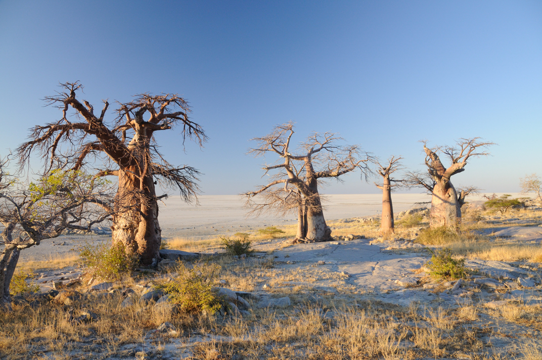
Kubu Island (Lekhubu in Setswana, meaning 'the island', and Ga'nnyo to the Khoe) is a granite outcrop on the southern edge of Sowa Pan, the largest of the Makgadikgadi salt pans, in north-eastern Botswana. It isn't an island in the usual sense. It's a rocky outcrop about 20 metres high and just over a kilometre long, crowned by ancient baobabs, in the middle of a plain of white salt that runs to the horizon. It is a National Monument of Botswana and a sacred site, managed by the Gaing-O Community Trust of Mmatshumo village.
📌Best time to go
Kubu can only be reached safely in the dry season, from May to October, when the salt crust around the island is firm enough to cross by 4x4. In those months the weather is cool and clear, ideal for camping. In the rainy season (December to April) the pan floods or turns into treacherous mud that can swallow a vehicle, and the island is practically cut off. The southern winter months (June-August) bring the clearest skies for starry nights, though the early mornings are very cold.
📌Suggested days
Kubu is a 1- or 2-night destination. That's enough time to get there, explore the island on foot, watch sunset and sunrise over the pan, sleep under a spectacular starry sky and take in the unique atmosphere of the place. Many travellers include it in a multi-day loop through the Makgadikgadi salt pans, combining it with Ntwetwe, Nata or Gweta. With no organised activities or services, you don't need more time: the experience is contemplative, all silence and landscape.
📌Getting there
You can only get there by 4x4, and only in the dry season. There are two usual routes. From the north, take a dirt track that leaves the tarred road about 10 km west of Nata and follow it for about 90 km to Kubu. From the south, go through the village of Mmatshumo, where the Gaing-O Trust office is, and then cross the pan. Either way, it's a good idea to stop in Mmatshumo or Nata to pay, let people know you're going and check the condition of the tracks. There's no public transport: it's either self-sufficient self-driving or an excursion with an operator from Gweta/Nata.
📌Getting around
On and around the island you get around on foot, following marked trails between the baobabs and the rocks and respecting the site's status as sacred ground and a National Monument. To get there and cross the surrounding pan you need a high-clearance 4x4 and experience driving on sand and salt. Never leave the marked tracks or head into areas of soft salt. You must bring all your water, food, fuel and firewood, because there are no services of any kind on the island.
📌Language and currency
The official language is English and the national language is Setswana; Kalanga is also spoken in the area. The currency is the pula (BWP); as of July 2026 the rate is around 13.5 to 14 pula to the dollar. Entry and camping fees are paid in cash (in pula) at the Gaing-O Trust office in Mmatshumo, or to the staff on the island. There are no ATMs, shops or reliable mobile signal, so bring enough cash and all your supplies from Nata or Gweta.
💱 BWP exchange rate
Loading rate…
🌤️ Weather in Kubu Island (Lekhubu)
Loading weather…

Kubu Island is one of the most surreal and awe-inspiring places in Africa: a granite outcrop crowned by baobabs over a thousand years old, stranded in a sea of white salt that stretches to the horizon. It looks like a stone ship run aground in a dry ocean, or a set from a science-fiction film. Its Setswana name, Lekhubu, means 'the island', and that says it all: when you see it rise out of the flat expanse of Sowa Pan, you understand why.

Kubu isn't just a geological oddity. It has been a sacred site since time immemorial: San peoples visited it and probably held initiation rites here, and its southern part holds mysterious, ancient dry-stone walls. Its slopes are terraced by old beaches of pebbles rounded by waves, fossil proof that this 'sea of salt' was once a real lake. Today it is a National Monument of Botswana, looked after by the Mmatshumo community.

This practical guide explains how to visit such a special and fragile place: how to get there by 4x4 (dry season only), where to pay the Gaing-O Trust community fees, what to see on the island (the ancient baobabs, the stone walls, the fossil beaches, the sunsets and the starry nights), and how to camp responsibly and self-sufficiently in one of the most magical corners of the Makgadikgadi salt pans.

📖 History of Kubu Island (Lekhubu)

Kubu Island is a granite outcrop more than two billion years old, crowned by ancient baobabs, rising on the edge of Sowa Pan, the bed of the ancient prehistoric Lake Makgadikgadi. Its terraces of wave-rounded pebbles are the fossil imprint of that great vanished lake. It was a sacred place for the San peoples, who called it Ga'nnyo and held spiritual rites here, and its southern part holds dry-stone walls whose origin is debated (some link them to the Great Zimbabwe culture). Declared a National Monument, it is now looked after by the Gaing-O Community Trust. Our history page tells its geological and human story.

Read the full history ↓

🏛️ Kubu Island (Lekhubu) is in the Kalahari and the salt pans

The great sea of sand and the remains of a prehistoric lake: ancestral land of the San, endless skies, ancient baobabs and white salt pans that stretch to the horizon.

Read the history of The Kalahari and the salt pans →

🗺️ What to see

1
The island's ancient baobabs
Huge, centuries-old baobabs, some over 2,000 years old, clinging to the granite above the pan.
Leer más ↓
Kubu's most iconic feature is its baobabs: huge, gnarled, ancient trees growing out of the granite, with the white pan behind them. Some of these giants are thought to be over 2,000 years old, which makes them living things older than many civilisations. Their silhouettes against the sunset sky, when the salt turns pink and gold, are among the most photographed images in Botswana. Baobabs are near-miracles of adaptation. They store water in their swollen trunks to survive the extreme drought of the pan, where the soil is salty and water scarce. On Kubu, clinging to the rock, they have withstood wind, heat and drought for centuries, silent witnesses to the San, the explorers and today's travellers. Walking among them in silence is the essence of the visit. Getting there: on foot, along the island's trails, once you've arrived by 4x4. Best time: dry season; sunset and sunrise give the best light. Tips: don't climb or damage the trees or carve anything into them. They are protected heritage.
ℹ️ Location: On the granite outcrop, all over the island · Best time to go: Dry season (May-October); sunrise and sunset light · Admission: Covered by the Gaing-O Trust entry fee; its tariff charges the walk around the island separately (see prices) · Duration: 1 to 2 hours exploring the island
2
The stone walls and the sacred site
Ancient dry-stone walls in the south of the island, traces of rituals and an enigmatic past.
Leer más ↓
The southern part of Kubu holds some mysterious dry-stone walls, up to just over a metre high, enclosing a roughly square space. Their origin and purpose are debated. The island is believed to have been a sacred place used for initiation rites by the San peoples and other communities in the region, and some researchers have tentatively suggested that the walls could be linked to the cultural sphere of Great Zimbabwe, the Shona kingdom that flourished between the 11th and 15th centuries. Stone tools and other remains found next to the walls confirm a long human presence at the site. For visitors, these remains give Kubu a spiritual and historical dimension: it's not just an astonishing landscape but a place full of ancestral meaning, best explored with respect. The Mmatshumo community, which manages the island, keeps that sacred character alive. Getting there: on foot, in the southern part of the island; follow the marked trails. Best time: dry season. Tips: don't move or take away stones or objects. This is a National Monument and a sacred site.
ℹ️ Location: Southern part of the outcrop · Best time to go: Dry season (May-October) · Admission: Covered by the Gaing-O Trust entry fee; the walk around the island is charged separately (see prices) · Duration: 30 to 60 minutes
3
The fossil pebble beaches
Terraces of wave-rounded pebbles, proof that a great prehistoric lake once lay here.
Leer más ↓
One of Kubu's most fascinating geological curiosities is its 'fossil beaches'. The island's slopes are terraced by bands of small, rounded pebbles, exactly like those waves leave on any sea or lake beach. And that's exactly what they were: beaches of the ancient Lake Makgadikgadi, which hundreds of thousands of years ago covered this whole region with water. The different terraces mark the levels the water reached at different times. Walking along these ancient shores is like travelling back in time. Where today there's a dry, cracked salt plain, waves once broke against the rock of Kubu, which was a true island in an inland sea. This detail turns the place into an open-air geology lesson and helps you understand where all the Makgadikgadi salt pans came from. For nature lovers, it's as interesting as the baobabs themselves. Getting there: on foot, on the island's slopes. Best time: dry season. Tips: notice how the pebbles have been polished and rounded by water. Don't collect them; they are part of the monument.
ℹ️ Location: Slopes of the granite outcrop · Best time to go: Dry season (May-October) · Admission: Covered by the entry fee; the walk around the island is listed separately in the tariff (see prices) · Duration: You see them as you explore the island
4
Sunsets and sunrises over the pan
The sun sinking into the endless white plain, painting the salt and the baobabs in impossible colours.
Leer más ↓
For many people, Kubu's sunsets and sunrises are the high point of the visit. With nothing on the horizon but the flat, endless salt plain, the sun seems to sink straight into the earth, painting the pan pink, orange and violet while the ancient baobabs stand out in black against the blazing sky. It's a serene, overwhelming kind of beauty that changes minute by minute. Sunrise is just as magical and even quieter: the cool light of dawn spills over the white salt and the island slowly wakes up. These moments, experienced in near-total solitude with only the sound of the wind, are why so many travellers consider Kubu one of the most special places in Africa. Find a high point on the island and take your time. Getting there: from any high point on the island, camping there the night before. Best time: dry season; cloudless nights. Tips: bring warm clothes (the dawn cold is intense), don't use strong torches that spoil the half-light, and respect other people's silence.
ℹ️ Location: High points on the island, above the pan · Best time to go: Dry season; clear skies · Admission: Included in your stay/camping fee · Duration: Sunset and sunrise (30-60 min each)
5
Starry night and camping on the island
Camping beside the baobabs, under one of the clearest, starriest night skies on the planet.
Leer más ↓
Spending the night on Kubu is unforgettable. The Mmatshumo community runs very basic, rustic campsites around the island, with nothing more than a few pit latrines, so you have to bring everything (water, food, firewood, gear). In return you get something priceless: sleeping next to ancient baobabs, in the middle of an endless salt pan, under one of the darkest and starriest skies on Earth. With no artificial light for hundreds of kilometres and the dry desert air, you can see the whole Milky Way crossing the sky, with the Magellanic Clouds and the Southern Cross shining sharply. The silence is absolute. Around the fire, with the silhouettes of the baobabs and the white vastness of the pan lit only by starlight, Kubu gives you one of those nights you remember for the rest of your life. Getting there: book/pay for camping with the Gaing-O Trust (in Mmatshumo or on the island). Best time: dry season, especially winter (May-August) for clear skies. Tips: bring everything, leave the place spotless (take all your rubbish with you) and respect the sacred character of the site.
ℹ️ Location: Community campsites around the island · Best time to go: Dry season (May-October); moonless nights · Admission: Camping: international visitors BWP 200 per person per night + entry BWP 100 + tourism levy BWP 10 per night (official Gaing-O tariff 2025-2027) · Duration: 1 to 2 nights
6
Crossing Sowa Pan
The 4x4 approach across the vast white salt, an adventure in itself.
Leer más ↓
Getting to Kubu is part of the experience. The island sits on the southern edge of Sowa Pan, the largest of the Makgadikgadi salt pans, and getting there means long stretches of salt plain and savannah by 4x4, following barely marked tracks, with the island slowly appearing on the horizon like a dark mirage against the white. The trip demands preparation, GPS and off-road experience, and it's only possible in the dry season. Crossing the pan, with its flat, endless horizon and its silence, sets the mood for arriving at Kubu. Every year, though, some careless travellers get stuck or sink when they leave the firm areas, especially when the salt is still holding moisture. That's why you must check the condition of the tracks in Mmatshumo or Nata before heading out, and never venture on your own into areas of soft salt. Getting there: from Nata (north, ~90 km of track) or Mmatshumo (south); always check road conditions. Best time: the height of the dry season (June-September). Tips: ideally travel in two vehicles, carry sand ladders/a shovel, and don't cross the pan if there's any doubt about how firm it is.
ℹ️ Location: Sowa Pan, from Nata (north) or Mmatshumo (south) · Best time to go: Height of the dry season (June-September) · Admission: No crossing fee; island access is paid to Gaing-O · Duration: Several hours' approach by 4x4
📶I have never landed without internet. I arrive and my phone connects to the strongest network in the country I am visiting: I can say I landed, sort out transport, book tours and keep posting, at a seriously good price. I always use the Maya eSIM — check their plans by clicking the banner.See plans →Maya Mobile eSIM — download, install, go
What nobody tells you

💵 Prices

Tickets

TypePrice
Entrada a la isla (visitante internacional)BWP 100 per person (official Gaing-O Community Trust tariff 2025-2027; prices exclude VAT)
Entrada (nacional de un país de la SADC / ciudadano de Botswana)BWP 60 for nationals of a SADC country and BWP 40 for citizens of Botswana, per person (official Gaing-O tariff 2025-2027)
Camping (visitante internacional, por persona/noche)BWP 200 (~USD 14) per person per night; children aged 6 to 14 BWP 100 and under-6s free (official Gaing-O tariff 2025-2027)
Camping (nacional de la SADC, por persona/noche)BWP 150 per person per night; children aged 6 to 14 BWP 75 and under-6s free (official Gaing-O tariff 2025-2027)
Camping (ciudadano de Botswana, por persona/noche)BWP 80 per person per night; children aged 6 to 14 BWP 40 and under-6s free (official Gaing-O tariff 2025-2027)
Tasa de turismo (obligatoria, por persona y noche)BWP 10 per person per night, the same for everyone (official Gaing-O tariff 2025-2027)
VehículoBWP 50 per vehicle under 5 tonnes and BWP 70 over 5 tonnes; motorbikes and bicycles BWP 30 (official Gaing-O tariff 2025-2027)
Caminata por la isla (se cobra aparte de la entrada)Self-guided: BWP 150 for international visitors, BWP 120 for SADC nationals and BWP 100 for citizens. Guided: BWP 80 per person for everyone (official Gaing-O tariff 2025-2027)
Extras del campamentoTent hire with two sleeping mats and solar lamps BWP 250 per day; firewood BWP 30 a bundle; viewpoint BWP 10; stargazing BWP 80; VIP site BWP 350 per person per night (official Gaing-O tariff 2025-2027)
🔄 updated monthlyOfficial / reference values · double-check when buying

Activities and tours

ActivityPriceDurationOperator
Walk around the island (baobabs, walls, fossil beaches)Charged separately from entry: BWP 150 self-guided (international) or BWP 80 with a trust guide1 to 2 hoursSelf-guided / Gaing-O Trust
Camping and starry nightBWP 200 per person per night (international visitors); guided stargazing is BWP 80 extra1 to 2 nightsGaing-O Community Trust
Guided excursion to Kubu from Gweta/NataDepends on the operator (day trip or overnight); ask for details (2025-2026)1 day or overnightSalt pan operators (Planet Baobab, Gweta lodges)
Sunset and sunrise photographyIncluded in your stayAt sunrise and sunsetSelf-guided
🔄 updated monthlyOfficial / reference values · double-check when buying

🚌 How to get there and distances

Getting around

Your own or a rented 4x4
PriceEquipped 4x4 hire from ~USD 150-250 per day in Maun (2025-2026)
DurationSeveral hours' approach
Notes
The only way to get there; dry season only. GPS, water, fuel and firewood are essential; don't leave the marked tracks
Excursion with an operator (from Gweta/Nata)
Depends on the operator
DurationFull day or overnight
Notes
An option if you don't drive a 4x4 or don't want to risk crossing the pan on your own
On foot (on the island)
Free
DurationVariable
Notes
The tour of the island is done on foot along the marked trails, respecting the sacred site
🔄 updated monthlyOfficial / reference values · double-check when buying

How to get there

RouteAirlines / operatorsAvg. priceDuration
Nata → Kubu Island (on a dirt track)Self-drive in a 4x4Your own fuel (2025-2026)~90 km of track; several hours depending on conditions
Gweta → Kubu Island via the salt pansSelf-drive / lodge excursionsYour own fuel or excursion feeHalf a day
Mmatshumo (Gaing-O office) → Kubu (south)Self-drive in a 4x4Your own fuelA couple of hours crossing the salt pan
Maun / Kasane → Nata (paved A3 road) → KubuSelf-drive / buses to NataFuel or bus fare to NataMaun-Nata ~3,5 h; then the track to Kubu
🔄 updated monthlyOfficial / reference values · double-check when buying

🏨 Where to stay

No exact prices: a scale from $ (budget) to $$$$$ (luxury), with 2-3 options per category.

Community campsite on the island
Price$$$$$
Recommended options
Rustic sites with no facilities (pit latrines only), BWP 200 per person per night (international visitors), BWP 150 (SADC) and BWP 80 (citizens), plus a BWP 10 tourism levy; you have to bring everything (water, food, firewood). There are VIP sites for BWP 350 and tent hire for BWP 250 per day. It's the only way to sleep on Kubu
Lodges and campsites in Gweta/Nata (base)
Price$$$$$
Recommended options
From ~USD 20-150 per person/night; Planet Baobab, Nata Lodge and Gweta Lodge on the A3, as a comfortable base before or after the trip to Kubu
Luxury salt pan lodges
Price$$$$$
Recommended options
USD 700-1.500+ per person/night (Jack's Camp, San Camp) for those who want to combine Kubu with a high-end stay in Makgadikgadi

🍴 Where to eat

Autoabastecimiento en la isla
Price$$$$$
Options / signature dish
There are no shops or restaurants on Kubu: you have to bring all your food, water and firewood. You cook at camp; take all your rubbish with you when you leave
Restaurantes y bares de Gweta/Nata
Price$$$$$
Options / signature dish
USD 10-25 per person at the lodges on the A3 (Planet Baobab, Nata Lodge), for a good meal before or after the crossing
Compras previas en Nata/Gweta
Price$$$$$
Options / signature dish
Supermarkets and petrol stations in Nata and Gweta; stock up on water, ice, food, fuel and firewood before heading into the salt pan

📖 History of Kubu Island (Lekhubu)

Origins, formation and what the sources say.

A two-billion-year-old rock

The story of Kubu Island begins in a past so distant it is hard to imagine. The granite outcrop on which the island stands formed more than two billion years ago, deep in the Earth's crust, as magma slowly cooled and crystallised into this hard, ancient rock. It is one of the oldest materials a traveller can set foot on: far older than complex life, older than the dinosaurs and, of course, older than humankind.

For aeons, that rock stayed buried or exposed as geological cycles came and went, until erosion and movements in the land left it outcropping on what is now the southern edge of Sowa Pan. Kubu's granite, which resists erosion, was left standing as a rocky 'island' rising from the surrounding plain, a geological feature that nature took an eternity to sculpt.

That extreme age is part of the place's mystery. Standing on Kubu, among baobabs that have lived for thousands of years and stone walls that are centuries old, on a rock billions of years old, in the middle of a salt pan that was once a sea, gives you a dizzying sense of how small you are against geological time. Few places in the world pack so many timescales into a single landscape.

en.wikipedia.org · Kubu Islandkubuisland.com

When Kubu was a real island

The name Kubu (Lekhubu, 'the island' in Setswana) is not a poetic metaphor: hundreds of thousands of years ago, this granite outcrop really was an island, surrounded by the waters of the great Lake Makgadikgadi. That palaeolake, fed by ancient rivers such as the proto-Zambezi and the Okavango, covered huge stretches of what is now northern Botswana, and Kubu rose from its waters as a rocky islet battered by the waves.

The evidence of that inland sea is etched into the island itself. Its slopes are terraced with bands of small pebbles, rounded and polished exactly like the ones waves shape on any beach: these are fossil beaches, old lake shores, and their different levels mark how high the water reached at different times. Walking along them means walking the beaches of an ocean that vanished thousands of years ago.

When the climate dried out and tectonic activity diverted the rivers that fed the lake, the water evaporated and left behind the salt flats that surround Kubu today. The 'island' was left stranded in a dry white sea, like a stone ship run aground. That contrast between its watery past and its desert present is one of the keys to understanding the magic of this place and of all the Makgadikgadi pans.

en.wikipedia.org · Kubu Islanden.wikipedia.org · Lake Makgadikgadi

Ga'nnyo: a sacred site for the peoples of the Kalahari

Long before the tourists arrived, Kubu was already a special place for the peoples who lived in the region. The Khoe called it Ga'nnyo, and there is evidence that the San (Bushmen) visited the island and probably held initiation rites and spiritual ceremonies here. In the middle of the flat, featureless vastness of the pan, this baobab-crowned outcrop must have stood out as a powerful place, full of meaning, a meeting point with the sacred.

Archaeological digs confirm a long human presence: stone tools have been found that, as at other spots around Makgadikgadi, date back to the Stone Age, when the lake still brought the area to life. Over thousands of years, the island was a refuge, a lookout and a sanctuary for hunter-gatherers and for the communities that came after them.

That sacred character is not just a thing of the past. The local community of Mmatshumo, which now runs the site through the Gaing-O Trust, keeps alive the idea of Kubu as a place that deserves respect. That is why visitors are asked to explore it with care, without damaging the trees or the structures and without taking stones or objects away: it is not just a tourist viewpoint, but a space with centuries of accumulated spiritual value.

en.wikipedia.org · Kubu Islandmaeasam.org · Lekhubu island

The riddle of the stone walls

One of Kubu's biggest mysteries is the stone structures that survive on the southern part of the island: dry-stone walls, up to just over a metre high, enclosing a roughly square space. Who built them, when and why? The answer is not entirely clear, and that only adds to the fascination of the place.

The most widely accepted theory links them to the island's ritual use: they may have served as an enclosure for ceremonies, perhaps the initiation rites for young people that tradition associates with Kubu. But there are more ambitious theories. Some researchers have cautiously suggested that the walls may have some connection with the cultural sphere of Great Zimbabwe, the powerful Shona kingdom that flourished between the 11th and 15th centuries and left impressive dry-stone buildings in what is now Zimbabwe. Kubu would have sat within that world's trade routes and sphere of influence.

Whatever their exact origin, the walls give Kubu a historical and archaeological dimension on top of its geology and its natural setting. Together with the stone tools found at the site, they tell us that this 'island' in the sea of salt was, for a long time, a place lived in, revered and worked by human hands. Its declaration as a National Monument of Botswana is meant precisely to protect that fragile, irreplaceable heritage.

en.wikipedia.org · Kubu Islandmaeasam.org · Lekhubu island

Kubu today: national monument and community tourism

Today, Kubu Island is both a National Monument of Botswana and a model of community tourism. It is run by the Gaing-O Community Trust, made up of residents of the nearby village of Mmatshumo, which collects the entrance and camping fees, looks after the sites and puts the income towards benefiting the local community. It is an example of how a sacred, fragile place can open up to visitors without losing its character, as long as they explore it with respect.

For travellers, Kubu has become one of Botswana's cult destinations: those who make it here (by 4x4, only in the dry season, after crossing the pan) are looking for exactly what it offers, which is the opposite of mass tourism. There are no luxury lodges, no organised activities, no crowds: just silence, ancient baobabs, fossil beaches, mysterious walls, and sunsets and starry nights that take your breath away. It is a contemplative destination, a place to switch off and be amazed.

Kubu's main challenge is conservation. Its remoteness protects it to some extent, but growing tourism and the odd disrespectful visitor threaten its baobabs and its heritage. That is why the community and the authorities insist on the rules: take all your rubbish with you, do not damage trees or stones, and do not camp outside the designated sites. Looked after this way, the island will remain what it has been for thousands of years: a unique place where geology, human history and landscape merge into something almost supernatural.

📚 Bibliography

  • Wikipedia (EN) — «Kubu Island»: https://en.wikipedia.org/wiki/Kubu_Island
  • Gaing-O Community Trust — Kubu Island (official site): https://www.kubuisland.com/
  • MEASAM (Mapping Africa's Endangered Archaeological Sites) — Lekhubu Island: https://maeasam.org/lekhubu-island/
  • Wikipedia (EN) — «Lake Makgadikgadi»: https://en.wikipedia.org/wiki/Lake_Makgadikgadi
  • Wikipedia (EN) — «Makgadikgadi Pan»: https://en.wikipedia.org/wiki/Makgadikgadi_Pan
  • Baobab Foundation — Kubu Island, where rock, salt and baobabs meet: https://baobabfoundation.co.za/kubu-island-makgadikgadi-pan-rock-salt-baobabs-meet/
  • Botswana Tourism Organisation — Makgadikgadi Pans: https://www.botswanatourism.co.bw/
  • Atlas Obscura — Kubu Island: https://www.atlasobscura.com/places/kubu-island
  • Ostrich Trails — Kubu Island guide: https://www.ostrichtrails.com/africa/botswana/kubu-island/
  • Wondermondo — Kubu Island (Ga'nnyo): https://www.wondermondo.com/kubu-island-gannyo/

❓ Frequently asked questions

When can you visit Kubu Island?+
Only in the dry season, roughly from May to October, when the salt crust around the island is firm and can be crossed in a 4x4. During the rainy season (December to April) the pan floods or turns into a dangerous mud bath that can swallow a vehicle, and the island becomes almost inaccessible. Before you go, always check track conditions in Mmatshumo or Nata.
How do I get there, and do I need a 4x4?+
Yes, you need a high-clearance, well-equipped 4x4. The two main routes are from Nata (a dirt track of about 90 km that leaves the paved road west of the town) and from the south via Mmatshumo, crossing the salt pan. There's no public transport. It's best to carry GPS, plenty of water, extra fuel, food and firewood, and ideally to travel with two vehicles. If you don't drive a 4x4, book an excursion from Gweta or Nata.
How much does it cost to get in and camp?+
The island is managed by the Gaing-O Community Trust, from Mmatshumo. Its official 2025-2027 price list charges international visitors BWP 100 entry per person and BWP 200 camping per person per night, plus a BWP 10 tourism levy per night and BWP 50 for the vehicle; nationals of SADC countries pay BWP 60 and 150, and Botswana citizens BWP 40 and 80. Prices do not include VAT. Payment is in cash, in pula, at the Mmatshumo office or to the staff on the island. The income supports the local community.
Are there any facilities on the island?+
Practically none. The campsites are very basic, with pit latrines and little else; there's no drinking water, electricity, shop, restaurant or mobile signal. You must be fully self-sufficient: bring all your water, food, fuel and firewood, and take absolutely all your rubbish with you when you leave. Kubu is a National Monument and a sacred site, so it has to be left spotless.
Why is it a sacred place, and what care should you take?+
Kubu (Ga'nnyo to the Khoe) was for centuries a spiritual site for the San peoples, who probably held initiation rites here, and it still has ancient stone walls and archaeological remains. It is a National Monument of Botswana. That's why visitors are asked to explore it with respect: don't climb or damage the baobabs, don't carve anything, don't move or take away stones or objects, stick to the marked trails and keep quiet. It's a place to contemplate, not to interfere with.

More places in Botswana

KasaneLinyantiMaunParque Nacional de ChobeParque Nacional Nxai PanReserva de Moremi
See every place in Botswana →The history of Botswana →
Sources consulted (6)
Still planning?
Explore more destinations in Botswana
See all destinations →
Image credits
Photos from Wikimedia Commons, each under its own licence (CC BY, CC BY-SA or public domain). Open each file to see its author and licence.
KubuIsland 02