📌Province
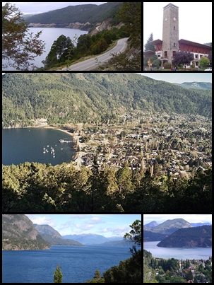
Neuquén. San Martín de los Andes sits in the southwest of the province, at the foot of the Andes and on the shore of Lago Lácar, within the area of influence of Parque Nacional Lanín. It's the seat of the Lácar department and one of the main destinations in southern Neuquén, famous for its mountain architecture and for being the northern end of the Ruta de los Siete Lagos
📌Service city
San Martín de los Andes itself has everything, concentrated along Avenida San Martín and the center: hotels, cabins, restaurants, tour agencies, banks, ATMs and a tourist office. It has the Aviador Carlos Campos airport (at Chapelco, about 20 km away) and a bus terminal. It's the base for Cerro Chapelco, Lago Lácar, Parque Nacional Lanín and the Ruta de los Siete Lagos
📌Best time to go
A year-round destination. Summer (December to March) is ideal for trekking, boat trips on Lago Lácar, beaches, kayaking and the Ruta de los Siete Lagos, with long days. Winter (June to September) draws skiers to Cerro Chapelco. Autumn turns the coihue, lenga and ñire forests red and gold, and tends to be quieter; spring brings snowmelt and wildflowers
📌Suggested days
2 to 3 days cover the essentials: the town center and the Lago Lácar waterfront, Quila Quina beach, Cerro Chapelco and a first stretch of the Ruta de los Siete Lagos. With 4 days or more you can add Lago Lolog, the Lanín volcano area, boat trips, more trails in Parque Nacional Lanín and the full Siete Lagos drive to Villa La Angostura at an easy pace
📌Currency
Argentine peso (ARS). With high inflation, peso prices move fast; we give official 2025-2026 rates plus dollar references as a guide. Bring cash for tours, park entry fees and Mapuche community access fees
💱 ARS exchange rate
Loading rate…
🌤️ Weather in San Martín de los Andes
Loading weather…
In southwestern Neuquén, spread along the eastern tip of Lago Lácar and ringed by forested hills, San Martín de los Andes is one of the prettiest mountain towns in Argentine Patagonia. Its center, with stone and timber houses, flower gardens and a distinctly alpine look protected by building code, slopes gently down to the lakefront, where clear water mirrors the peaks. It's both a quiet retreat and an unbeatable base for exploring the lake district.
The town began as a military outpost in 1898, in the middle of the border dispute with Chile, and over time became a top-tier destination. Today it has it all: Cerro Chapelco for skiing in winter and for hiking and big views the rest of the year; Lago Lácar for boat trips, kayaking and beaches like Quila Quina and Catritre; and the imposing Parque Nacional Lanín, dominated by the perfect cone of the Lanín volcano, with its araucaria forests, lakes and trails.
San Martín de los Andes is also the northern end of the legendary Ruta de los Siete Lagos, the scenic stretch of Ruta Nacional 40 that links it with Villa La Angostura through forests and sheets of water. Nature, mountains, lakes, Patagonian food and a charming town center make it one of the great classics of Argentine travel and an ideal starting point for touring the whole Neuquén cordillera.
✍️ I have been here
Forty hours on a bus to Patagonia
My first time in Patagonia, in 2015, for a tourism congress: forty hours on a bus from Posadas. We walked inside Lanín National Park, and today, living in South Lake Tahoe, I often think how alike the two are: a small town against a mountain, with a big lake in front.
Read my full story →Gus, author of this guide. Told first-hand, with my own photos.
📖 History of San Martín de los Andes
Long before the town existed, the Lago Lácar region and the foot of the Lanín volcano were inhabited by indigenous peoples, above all Mapuche communities who occupied these mountain territories as part of the araucanización process between the 18th and 19th centuries, joining earlier populations. Local place names — Lácar, Lolog, Quila Quina, Chapelco — preserve that deep imprint. San Martín de los Andes was officially founded on 4 February 1898 by Colonel Celestino Pérez, on orders from the army chief, General Rudecindo Roca, as a military outpost meant to assert Argentine sovereignty in an area disputed with Chile: the Chilean authorities argued that, since Lago Lácar drains towards the Pacific, the area should belong to them. The border question was later settled by arbitration. In its first decades the town's economy rested on logging and livestock. A turning point came with the creation of Parque Nacional Lanín in 1937, which protected the forests, the lakes and the volcano and put the area on the map as a tourist destination. Since then, boosted by skiing at Cerro Chapelco and by the Ruta de los Siete Lagos, San Martín de los Andes has become one of the most important tourism centers in Patagonia, while keeping the scale of a mountain town and the carefully guarded architecture that is part of its identity. The full story is on our history page.
Read the full history ↓🏛️ San Martín de los Andes is in Neuquén
The province of volcanoes, lakes and the araucaria: Pehuenche and Mapuche land in northern Patagonia, world capital of the giant dinosaurs, heart of the Vaca Muerta shale and gateway to the Route of the Seven Lakes.
Read the history of Neuquén →🗺️ What to see
Tours you can book
A local guide tells you in half an hour what no sign at the site will ever explain. We look ours up on Civitatis: guided in Spanish and booked online with no fuss. They have 6 activities in San Martin De Los Andes. Have a look below: tap any of them to see them all.
If you book from here we earn a commission and you pay no more. Prices and availability come from Civitatis.
1
Lago Lácar and the waterfront
The great glacial lake the town sits on, with a waterfront promenade, beaches and boat trips.
Leer más ↓
The Lácar is the heart of San Martín de los Andes: a clear glacial lake that drains towards the Pacific, ringed by forested hills. Its waterfront is the center of social life: perfect for walking, sitting to watch the water and the mountains, drinking mate and seeing the boats leave. From the pier, boats sail to Quila Quina beach and to Hua Hum, on the Chilean border, crossing Andean-Patagonian forest scenery that justifies the trip on its own.
ℹ️ Free access to the waterfront; boat trip to Quila Quina or Hua Hum US$ 25–55 per person round trip depending on the destination (range based on Naviera Nonthué and agencies, verified July 2026).
2
The most important ski resort in northern Patagonia, about 20 km from town.
Leer más ↓
Chapelco is why half the country knows San Martín de los Andes in winter: dozens of runs for every level, modern lifts (including a gondola) and views of the Lanín volcano and the lakes. From June to September it's one of Argentina's leading snow destinations, with a ski school and a snow garden for kids. The rest of the year it works as a panoramic viewpoint and a base for hiking, mountain biking and mountain activities, with the lifts running to take you up.
ℹ️ Day ski pass ARS 160,000, foot-passenger pass ARS 30,000, Neuquén residents ARS 120,000 (source: cerrochapelco.com.ar, 2026 season, verified July 2026); transfer from town US$ 10–20 round trip.
3
Playa Quila Quina
The most beautiful beach on Lago Lácar, in a forested bay with a Mapuche community and craft market.
Leer más ↓
Quila Quina is the summer classic: a sandy bay with calm water surrounded by forest, inside the territory of the Curruhuinca Mapuche community, reached by a mountain road or by boat from the town pier (the more scenic option). Besides the beach there are short trails — such as the one to the stream and the waterfall — a community craft market and food stands. In January and February, go early: it fills up.
ℹ️ Access by mountain road (12 km from the RP 108) or by catamaran/launch from the pier; access fee US$ 3–6 charged by the community (range based on travel blogs, verified July 2026).
4
Araucaria forests, huge lakes and the perfect cone of the Lanín volcano (3,776 m).
Leer más ↓
Created in 1937, Parque Nacional Lanín is one of the most striking in Patagonia: it protects forests of ancient araucarias, coihues, lengas and raulíes, lakes such as Huechulafquen, Paimún and the Lácar itself, and dozens of trails. It's dominated by the Lanín volcano, an almost perfect 3,776-meter cone that is the roof of the region and one of the most photographed landscapes in southern Argentina. San Martín de los Andes is one of its main gateways, with access to trails, beaches, campsites and climbs (the volcano ascent requires registration and experience).
ℹ️ Entry fee ARS 35,000 general rate / ARS 15,000 Argentine residents / ARS 8,000 provincial residents (source: Administración de Parques Nacionales, rates in force since June 2026, verified July 2026); 50% off on the second day.
5
Mirador Bandurrias
The classic Lago Lácar lookout, with a trail from the center and a Mapuche market.
Leer más ↓
This is the town's most popular walk: a trail of about an hour and a half through cypress and radal trees that starts near the center (crossing the Pocahullo stream) and climbs to a natural balcony with a panoramic view of Lago Lácar, the town and the mountains. The lookout is on land of the Curruhuinca Mapuche community, which runs a craft market and a small shelter serving tortas fritas and drinks. You can also drive up on a gravel road.
ℹ️ Trail of ~1.5 h from the center (easy to moderate) or vehicle access; the community charges a fee of US$ 2–4 (range based on visitor reviews, verified July 2026).
6
Mirador del Arrayán and tea house
The best high view over the Lácar, with a historic mountain tea house.
Leer más ↓
On the heights around town, about 4 km from the center, the Mirador del Arrayán offers one of the finest views over Lago Lácar and the town, especially at sunset. Beside it stands the historic El Arrayán tea house, built in 1939 in mountain style by English pioneer Renée Dickinson, a traditional spot for afternoon tea with exceptional views: tea, cakes, scones and Patagonian baking in front of the picture window.
ℹ️ About 4 km from the center on a signposted road; free access to the lookout; afternoon tea at the tea house US$ 10–20 per person (range based on Tripadvisor reviews, verified July 2026).
7
Lago Lolog
A quiet lake with crystal-clear water 15 km away, good for fishing, kayaking and a beach without crowds.
Leer más ↓
About 15 km north of town, the Lolog is the quiet alternative to the Lácar: a crystal-clear lake surrounded by forest and hills, a favorite for trout fishing, kayaking, camping and doing nothing. Playa Bonita and the Puerto Arturo area are the most used access points. Less busy than the Lácar even in January, it makes a good half-day or full-day outing for anyone after nature at a slow pace.
ℹ️ 15 km via the RP 62 (partly gravel); free access; fishing requires a Patagonian sport fishing permit.
8
Ruta de los Siete Lagos
Patagonia's most famous scenic drive: 110 km of lakes and forest to Villa La Angostura.
Leer más ↓
San Martín de los Andes is the northern end of the legendary Ruta de los Siete Lagos, the stretch of Ruta Nacional 40 that links it with Villa La Angostura past the Lácar, Machónico, Falkner, Villarino, Escondido, Correntoso and Espejo lakes, through the forests of Parque Nacional Lanín and Parque Nacional Nahuel Huapi. It's about 110 km, fully paved, with signposted viewpoints, beaches, waterfalls (such as Vuliñanco) and campsites. You can do it as a day return trip, on an organized tour, by bike if you're fit, or as a leg of the journey to Bariloche.
ℹ️ 110 km on the RN 40 to Villa La Angostura, no tolls or entry fees; on your own, just fuel (US$ 15–25 round trip); organized tour US$ 40–80 per person (range based on local agencies, verified July 2026).
9
Playa Catritre and the south shore of the Lácar
A sandy beach with services 4 km from the center, on the way to the Siete Lagos.
Leer más ↓
Catritre is the most accessible beach on the Lácar: about 4 km from the center on the south shore of the lake, on the way to the Ruta de los Siete Lagos, with sand, forest, calm water and superb views. Run by the Curruhuinca Mapuche community, it has a food stand, a campsite and services, which makes it easy for families spending the day. It's the perfect complement to Quila Quina for enjoying the lake in summer without depending on boats.
ℹ️ ~4 km from the center on RN 40/RP 108; access or parking fee US$ 3–6 (range based on travel blogs, verified July 2026).
10
The center and Avenida San Martín (mountain architecture)
A town center of stone and timber, with chocolate shops, smokehouses and craft breweries.
Leer más ↓
The center of San Martín de los Andes is an attraction in itself: the stone, timber and steep-roofed architecture is protected by building code, giving the town an alpine look unique in Argentine Patagonia. Avenida San Martín is lined with chocolate shops, smokehouses (trout, venison, wild boar), craft breweries, craft stores and outdoor gear shops. Plaza San Martín, the Centro Cívico with its historic stone buildings and the tourist office round out the walk, ideal for the afternoon or a rainy day.
ℹ️ Free access; tourist office facing Plaza San Martín (Av. San Martín and J. M. de Rosas).
💵 Prices
Tickets
| Type | Price |
|---|
| Parque Nacional Lanín — entry fee (per person/day) | ARS 35,000 general rate, ARS 15,000 Argentine residents, ARS 8,000 provincial residents, ARS 12,000 students (approx. US$ 25 / US$ 10.5 / US$ 5.5 / US$ 8.5 at the current rate; source: Administración de Parques Nacionales, rates in force since 1 June 2026, verified July 2026). There's 50% off on the second day (within 72 h) and a Flexipass system; at some gates the fee is collected by Mapuche communities |
| Cerro Chapelco — ski pass (winter season) | Ski pass ARS 160,000 for tourists and non-residents / ARS 120,000 Neuquén residents; foot-passenger pass ARS 30,000 (approx. US$ 110 / US$ 84 / US$ 21 at the current rate; source: cerrochapelco.com.ar, 2026 season price list, verified July 2026). Plus a pass-holder card, ARS 7,000 |
| Cerro Chapelco — summer lifts (viewpoint) | US$ 20–40 per person (range based on agencies and Interpatagonia, verified July 2026) |
| Playa Quila Quina (road access) and Catritre | US$ 3–6 per vehicle or person as an access or parking fee charged by the Mapuche community (range based on travel blogs, verified July 2026) |
| Mirador Bandurrias / Mirador del Arrayán | Trail access generally free; at Bandurrias the Mapuche community may charge a fee of US$ 2–4 (range based on visitor reviews, verified July 2026) |
| Boat trips on Lago Lácar (Quila Quina / Hua Hum) | US$ 25–55 per person round trip depending on destination and operator (range based on Naviera Nonthué and local agencies, verified July 2026) |
| Ruta de los Siete Lagos | A public road, no entry fee; just fuel (premium petrol ~US$ 1–1.2/liter) or an organized tour (verified July 2026) |
🔄 updated monthlyOfficial / reference values · double-check when buying
Activities and tours
Skiing and snowboarding at Cerro Chapelco
PriceDay pass ARS 160,000 tourists / ARS 120,000 Neuquén residents (approx. US$ 110 / US$ 84, source: cerrochapelco.com.ar, 2026 season, verified July 2026); gear rental extra (US$ 25–40/day, range based on local agencies)
Boat trip on Lago Lácar to Quila Quina or Hua Hum
PriceUS$ 25–55 per person round trip depending on destination (range based on Naviera Nonthué and agencies, verified July 2026)
Driving the Ruta de los Siete Lagos
PriceOn your own, just fuel (US$ 15–25 of petrol round trip); organized tour US$ 40–80 per person (range based on local agencies, verified July 2026)
Trekking in Parque Nacional Lanín
PricePark entry (ARS 15,000 Argentine residents / ARS 35,000 general rate, source: Administración de Parques Nacionales, verified July 2026); optional guide US$ 30–70 per group depending on the trail
Kayaking, fishing and water sports on the lakes
PriceKayak rental US$ 10–25 per hour; guided boat fishing trip US$ 80–180 per day (range based on local operators, verified July 2026; fishing requires a permit)
Mountain biking and forest trails
PriceBike rental US$ 15–30 per day; e-bike US$ 25–45 (range based on local bike shops, verified July 2026)
Visit to Quila Quina and the Curruhuinca Mapuche community
PriceAccess fee US$ 3–6; optional boat trip or tour US$ 25–45 per person (range based on local operators, verified July 2026)
🔄 updated monthlyOfficial / reference values · double-check when buying
🚌 How to get there and distances
Getting around
On foot (center and waterfront)
Free
NotesThe center and the Lago Lácar waterfront are easy to walk, with shops, restaurants and agencies packed into a few blocks. For tours, beaches and lookouts you'll want a vehicle or a transfer.
PriceRental US$ 15–30 per day (regular bike); e-bike US$ 25–45 (range based on local bike shops, verified July 2026)
NotesA good option for the waterfront, nearby trails and some lookouts. Bike shops and agencies rent both regular and electric bikes. Check road conditions and the weather.
PriceFuel only (premium petrol ~US$ 1–1.2/liter); rental from US$ 40–60 per day (range based on online rental agencies, verified July 2026)
NotesThe most comfortable way to get around the surroundings, Cerro Chapelco, lakes Lolog and Lácar and, above all, the Ruta de los Siete Lagos. Fill up the tank and check road conditions, especially in winter.
Transfers and organized tours
PriceTransfer to Cerro Chapelco US$ 10–20 round trip; tours US$ 40–80 depending on the destination (range based on local agencies, verified July 2026)
NotesLocal agencies run transfers to Cerro Chapelco, the Siete Lagos, Parque Nacional Lanín and other spots, useful if you're not driving.
Taxis, remises and city buses
PriceRides in town US$ 4–8; to Chapelco airport US$ 12–20; city bus ARS 800–1,200 (range based on local rates, verified July 2026)
NotesAvailable for trips within town and to nearby points; in high season book ahead. Public transport connects some neighborhoods and the Chapelco airport area.
🔄 updated monthlyOfficial / reference values · double-check when buying
How to get there
Buenos Aires → San Martín de los Andes (by air)
Airlines / operatorsAerolíneas Argentinas and JetSMART to Aviador Carlos Campos airport (Chapelco, about 20 km away); flying to Bariloche and continuing overland is also an option
Avg. priceUS$ 60–160 one way depending on how far ahead you book and the airline (source: Kayak and Turismocity, verified July 2026) + transfer
Bariloche → San Martín de los Andes (by car on the Ruta de los Siete Lagos)
Airlines / operatorsOwn or rental car on Ruta Nacional 40, via Villa La Angostura and the Camino de los Siete Lagos
Avg. priceFuel only (US$ 20–30 of petrol, range based on YPF, verified July 2026)
Bariloche → San Martín de los Andes (by bus)
Avg. priceUS$ 12–25 by coach (range based on online ticket sellers, verified July 2026)
Villa La Angostura → San Martín de los Andes (Ruta de los Siete Lagos)
Avg. priceFuel US$ 10–15; coach ticket US$ 8–15 (range based on local agencies, verified July 2026)
Buenos Aires → San Martín de los Andes (long-distance bus)
Airlines / operatorsVía Bariloche, Andesmar and other companies serving the lake district (direct or via Neuquén/Bariloche)
Avg. priceUS$ 55–95 depending on class (cama/semicama, range based on online ticket sellers, verified July 2026)
🔄 updated monthlyOfficial / reference values · double-check when buying
🏨 Where to stay
No exact prices: a scale from $ (budget) to $$$$$ (luxury), with 2-3 options per category.
Hostels, apartments and camping (budget)
Recommended optionsUS$ 25–55 a night; hostels, apartments and campsites in town and near the lakes, ideal for backpackers and for driving the Ruta de los Siete Lagos (range based on Booking and Tripadvisor, verified July 2026). Book ahead in high season
Cabins, hosterías and mid-range hotels
Recommended optionsUS$ 60–130 a night; a wide choice of mountain cabins, hosterías and family hotels in the center and around it, with good value and forest settings (range based on Booking, verified July 2026). The most popular choice for families
4-star hotels with full services
Recommended optionsUS$ 120–230 a night; upper-tier hotels in the center and near the lake, with spa, heated pool and restaurant (range based on Booking and Expedia, verified July 2026). Book well ahead in summer and winter
Boutique hotels and luxury lodges
Recommended optionsUS$ 220–500 a night; high-end lodges and hosterías up on the heights with lake views or near Chapelco, with spa, chef-driven dining and mountain design (range based on luxury booking aggregators, verified July 2026), aimed at couples and premium downtime
🍴 Where to eat
Cafés, tea houses, chocolate and regional sweets
Options / signature dishUS$ 5–12 per person; confiterías, tea houses and chocolate shops for afternoon tea with pastries, Patagonian chocolate, artisan preserves and coffee (range based on Tripadvisor reviews, verified July 2026)
Craft breweries and mountain cooking
Options / signature dishUS$ 12–28 per person; a strong craft beer culture, with breweries and pubs serving boards, burgers, picadas and mountain dishes in a relaxed setting (range based on Tripadvisor, verified July 2026). An après-ski classic
Parrillas, smoked meats and trout
Options / signature dishUS$ 18–40 per person; grills with Patagonian lamb and beef, artisan smoked products (trout, venison, wild boar) and fish from the lakes (range based on travel blogs and Tripadvisor, verified July 2026). The typical flavors of the south
Patagonian and chef-driven restaurants
Options / signature dishUS$ 35–80 per person; regional and contemporary cooking with lamb, venison, wild boar, trout, mushrooms and forest berries, in highly rated restaurants and bistros (range based on Tripadvisor, verified July 2026). Worth booking in high season
📖 History of San Martín de los Andes
Origins, formation and what the sources say.
The indigenous peoples and the araucanización
Why does a lake that rises in Argentina end up draining into the Pacific Ocean, on the other side of the continent? That geographical oddity of Lago Lácar — which drains towards Chile through the Hua Hum river — isn't just a textbook curiosity: it was, as we'll see, the origin of a border dispute that ended up giving the town of San Martín de los Andes its name and its reason to exist. But long before that dispute, and long before a single street was laid out, this basin was already a lived-in territory, crossed and contested by the peoples who inhabited it.
The Lago Lácar region, at the foot of the Lanín volcano, was home for centuries to communities that lived by hunting, fishing and gathering in a territory of Andean-Patagonian forest, glacial lakes and mountains under snow for much of the year. The lakes and the mountain passes — the Hua Hum pass among them — weren't barriers but lines of communication: trade routes for goods, people and news between the two sides of the Andes, long before there was any border drawn on a map.
Between the 18th and 19th centuries came the process historians call araucanización: Mapuche communities — originally from the other side of the mountains, in what is now Chile — gradually crossed over and settled in these territories, merging with the peoples already there (such as the Pehuenche, gatherers of the araucaria pine nut) and spreading their language, Mapudungun, and their culture across the whole Andean-Patagonian region. The mark of that indigenous presence runs deep and is still strongly felt in the area, well beyond tourist folklore.
Local place names preserve that legacy in every word on the road signs today: Lácar ('place of dryness or disappearance', by some readings), Lolog, Quila Quina ('place of canes and thorns'), Chapelco, and Lanín itself, a word said to refer to something 'dying' or 'dead' in reference to the extinct volcano. Mapuche communities such as the Curruhuinca still live in the area — at Quila Quina and around the town, for example, on land legally recognized after long struggles for communal title — keeping their identity, their language and their practices alive, and today sharing part of that culture, through community tourism and craft markets, with visitors who arrived expecting only scenery.
The 1898 founding and the border question with Chile
San Martín de los Andes was officially founded on 4 February 1898 by Colonel Celestino Pérez, on orders from the army chief, General Rudecindo Roca. Unlike many towns that grew out of trade or farming settlement, its origin was strictly military and strategic: the point was to set up an army post that would assert Argentine presence and sovereignty in an area then in the middle of a border dispute with Chile.
The sticking point was geography. For much of the 19th century the criterion for fixing the border was the watershed divide: land whose rivers drained towards the Pacific would tend to fall on the Chilean side, and land draining towards the Atlantic on the Argentine side. The problem is that Lago Lácar drains towards the Pacific, so the Chilean authorities argued that the San Martín de los Andes area should be theirs. Founding an Argentine settlement there was, therefore, a way of staking sovereignty over claimed territory.
The dispute was eventually settled through diplomacy and the international arbitration of the early 20th century, which combined the highest-peaks criterion with the watershed one and left the Lago Lácar region on the Argentine side. The town born as a military outpost was thus definitively folded into Argentine Patagonia, where it would grow over time.
The lake that drains to the Pacific: the background to the border conflict
The watershed criterion for fixing the border with Chile created a dilemma at Lago Lácar, whose waters drain towards the Pacific Ocean. That is why Chile claimed the area as its own. Founding San Martín de los Andes as a military outpost in 1898 was an attempt to assert Argentine sovereignty over that disputed territory, which finally stayed on the Argentine side after the border agreements and arbitrations of the early 20th century.
Source: https://en.wikipedia.org/wiki/San_Mart%C3%ADn_de_los_Andes
The pioneers, timber and livestock
After the founding, San Martín de los Andes grew slowly as an isolated mountain town, with harsh winters and difficult communications. The soldiers and first settlers were joined by criollo families, Mapuche settlers and European immigrants who put down roots in the Lago Lácar valley and the neighboring hamlets, looking for work and land.
In its first decades, the local economy rested above all on logging and livestock. The area's forests provided timber, worked in sawmills, while animal raising made use of the mountain fields and valleys. It was a hard life, shaped by the climate and by the distance from the country's main centers.
Those pioneers laid the foundations of local society and gave the town its first productive profile. Over time, though, conservation and the pull of the lakes and mountains would come to matter more than timber and cattle, opening the way to the tourism calling that defines the town today.
Parque Nacional Lanín and the birth of tourism
The great turning point in the history of San Martín de los Andes came with the creation of Parque Nacional Lanín in 1937. Protecting the araucaria, coihue and lenga forests, the lakes and the imposing Lanín volcano completely changed the town's fate: from a timber and livestock center it slowly became a tourist destination.
The park gave the region a framework for conservation and infrastructure, and put an exceptional landscape in the spotlight. Over the following decades came skiing at Cerro Chapelco, the growing fame of the Ruta de los Siete Lagos towards Villa La Angostura and the boom in nature tourism, sport fishing and trekking. San Martín de los Andes established itself as one of the most important tourism centers in Patagonia.
One distinctive feature of its growth was care for the look of the town. It adopted a building code that favors mountain architecture in stone and timber, with controlled heights and styles, which earned it a reputation as a tidy town in harmony with its setting. Keeping its scale and its character, San Martín de los Andes has reached the present as one of the best-loved destinations in southern Argentina, the gateway to Parque Nacional Lanín and the northern end of the legendary Ruta de los Siete Lagos.
📚 Bibliography
- Wikipedia (ES) — «San Martín de los Andes»: https://es.wikipedia.org/wiki/San_Mart%C3%ADn_de_los_Andes
- Wikipedia (EN) — «San Martín de los Andes»: https://en.wikipedia.org/wiki/San_Mart%C3%ADn_de_los_Andes
- Municipalidad de San Martín de los Andes — «Nuestra historia»: http://www.sanmartindelosandes.gov.ar/turismo/ciudad/nuestra_historia
- Billiken — «Historia y curiosidades de San Martín de los Andes»: https://billiken.lat/mi-pais/historia-y-curiosidades-de-san-martin-de-los-andes-a-128-anos-de-su-fundacion/
- Neuquén Turismo — «San Martín de los Andes»: https://web.archive.org/web/20240526064952/http://neuquentur.gob.ar/en/destinations/san-martin-de-los-andes/
- La Angostura Digital (archivo) — «San Martín de los Andes y su rica historia a través de 122 años»: https://www.archivo.laangosturadigital.com.ar/historia/san-martin-de-los-andes-y-su-rica-historia-a-traves-de-122-anos
- Administración de Parques Nacionales — «Parque Nacional Lanín»: https://www.argentina.gob.ar/parquesnacionales/lanin
- Wikipedia (ES) — «Parque nacional Lanín»: https://es.wikipedia.org/wiki/Parque_nacional_Lan%C3%ADn
- Wikipedia (ES) — «Volcán Lanín»: https://es.wikipedia.org/wiki/Volc%C3%A1n_Lan%C3%ADn
- Interpatagonia — «San Martín de los Andes»: https://www.interpatagonia.com/sanmartindelosandes/
❓ Frequently asked questions
Why is it called San Martín de los Andes?+
The town is named after General José de San Martín, the Liberator, in tribute to the national hero, with 'de los Andes' added for its position at the foot of the cordillera. It was founded as a military outpost on 4 February 1898 by Colonel Celestino Pérez, as part of the effort to assert Argentine sovereignty in an area then disputed with Chile.
When is the best time to visit?+
It depends on what you're after. Summer (December to March) is ideal for trekking, lakes, beaches, kayaking and the Ruta de los Siete Lagos, with long days. Winter (June to September) draws skiers to Cerro Chapelco. Autumn turns the forests red and gold and tends to be quieter. It's a year-round destination.
How do I get to San Martín de los Andes?+
You can fly to Aviador Carlos Campos airport (Chapelco, about 20 km away) or to Bariloche and continue overland. By car or bus, it's about 3 to 4 hours from Bariloche, either on the Ruta de los Siete Lagos (via Villa La Angostura) or on the Paso Córdoba road. There are also long-distance buses from Buenos Aires (around 20 to 22 hours).
What is the Ruta de los Siete Lagos and where does it start?+
It's the famous scenic drive on Ruta Nacional 40 that links San Martín de los Andes with Villa La Angostura (some 110 km), running through forest and past the seven lakes it's named for, inside Parque Nacional Lanín and Parque Nacional Nahuel Huapi. San Martín de los Andes is its northern end: many travelers use it as the starting point.
Can you see the Lanín volcano from town?+
The Lanín volcano, with its almost perfect 3,776-meter cone, is the great icon of Parque Nacional Lanín. It isn't always visible from the town center, but you can see it from several lookouts, from Cerro Chapelco and above all from the Huechulafquen and Paimún lakes area and other points in the park. It's one of the most impressive sights in the region.
Is it worth combining the visit with Villa La Angostura and Bariloche?+
Yes, and it's very common. San Martín de los Andes is the northern end of the Ruta de los Siete Lagos towards Villa La Angostura (some 110 km), which in turn is 80-90 km from Bariloche. Many travelers cover all three on the same trip, taking in the whole lake district.
What should I keep in mind about the weather and the tours?+
Mountain weather changes fast: bring warm layers, waterproofs and comfortable footwear whatever the season, summer included. In Parque Nacional Lanín you have to respect opening hours, rules and trail registration, and carry water and sun protection. In winter, check road conditions and snow conditions, especially for Chapelco and the Ruta de los Siete Lagos.
How much does it cost to ski at Chapelco?+
For the 2026 winter season, the day ski pass costs ARS 160,000 (about US$ 110) and the foot-passenger pass ARS 30,000; Neuquén residents pay ARS 120,000 (source: cerrochapelco.com.ar, verified July 2026). On top of that comes gear rental (US$ 25–40 per day), lessons if you need them and the transfer from town (US$ 10–20 round trip). Multi-day or advance-purchase passes bring the daily price down.
How much is admission to Parque Nacional Lanín?+
Since June 2026, the entry fee is ARS 35,000 at the general rate (about US$ 25), ARS 15,000 for Argentine residents, ARS 12,000 for students and ARS 8,000 for Neuquén residents; pensioners, children under 6 and people with disabilities go free (source: Administración de Parques Nacionales, verified July 2026). The second day is 50% off within 72 hours, and at some gates the fee is collected by the Mapuche communities.
Sources consulted (19)
- https://en.wikipedia.org/wiki/San_Mart%C3%ADn_de_los_Andes
- http://www.sanmartindelosandes.gov.ar/turismo/ciudad/nuestra_historia
- https://billiken.lat/mi-pais/historia-y-curiosidades-de-san-martin-de-los-andes-a-128-anos-de-su-fundacion/
- http://neuquentur.gob.ar/en/destinations/san-martin-de-los-andes/ · archived copy from 2024
- https://www.interpatagonia.com/sanmartindelosandes/seven-lakes-route.html
- http://neuquentur.gob.ar/en/destinations/san-martin-de-los-andes/ · archived copy from 2024
- https://revistadigital.culturademontania.org.ar/articulo/63a594e01043d2136d64ddfe
- https://www.argentina.gob.ar/parquesnacionales/lanin
- Tarifas Parque Nacional Lanín (Administración de Parques Nacionales): https://www.argentina.gob.ar/interior/ambiente/parquesnacionales/lanin/tarifas
- Tarifario esquí y snowboard Cerro Chapelco (oficial): https://www.cerrochapelco.com.ar/tarifario-esqui-y-snowboard-cerro-chapelco/
- https://www.rome2rio.com/s/Bariloche/San-Martin-de-los-Andes
- https://www.argentina.travel/en/news/route-of-the-7-lakes-a-journey-between-villa-la-angostura-san-martin-de-los-andes-and-bariloche
- https://www.villalaangosturaturismo.gob.ar/en/atractivo/route-of-the-7-lakes/
- Vuelos Buenos Aires-San Martín de los Andes (Kayak): https://www.kayak.com.ar/vuelos/Buenos-Aires-BUE/San-Martin-de-los-Andes-Chapelco-CPC
- Vuelos Buenos Aires-San Martín de los Andes (Turismocity): https://www.turismocity.com.ar/vuelos-baratos-a-CPC-san_martin_de_los_andes
- https://solsalute.com/blog/ruta-de-los-7-lagos-argentina-seven-lakes-route/
- http://neuquentur.gob.ar/en/destinations/san-martin-de-los-andes/ · archived copy from 2024
- https://www.interpatagonia.com/sanmartindelosandes/
- Hoteles en San Martín de los Andes (Booking.com): https://www.booking.com/city/ar/san-martin-de-los-andes.html