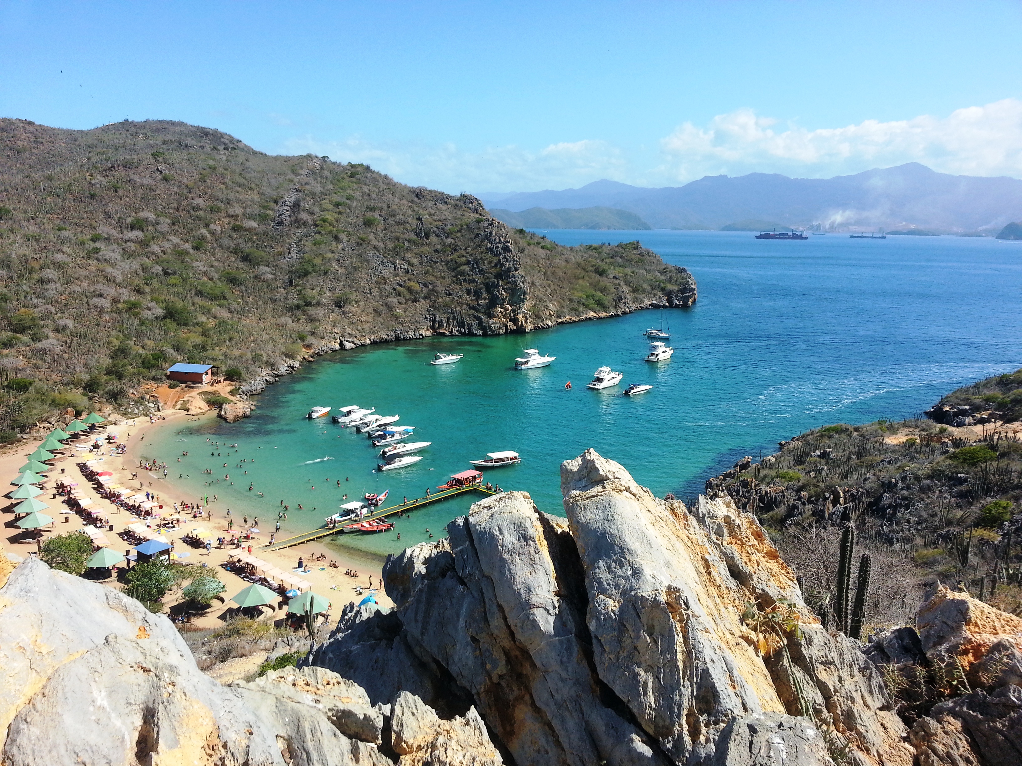
Mochima National Park is one of the great treasures of the Venezuelan Caribbean: an archipelago of islands, cays, bays and inlets of turquoise water spread across the states of Anzoátegui and Sucre, in the east of the country. Established in 1973, it combines mountainous coasts dropping sheer into the sea, pale sand beaches, mangroves and seabeds rich in life, ideal for snorkeling and diving.
The park can be enjoyed from several bases: Puerto La Cruz and Barcelona to the west, the picturesque village of Mochima in the middle, and Cumaná to the east. Boats ('peñeros' or 'taxi botes') run from all of them to islands such as Isla de Plata, the beaches of Conoma and Conomita, the local cays and the hidden bays that made Mochima famous. It's an accessible destination and, at the same time, full of corners for anyone wanting to switch off between mountain and sea.
This guide covers the essentials of Mochima National Park: which islands and beaches to visit, how to organize the boat trips, where to dive, what to see in the village of Mochima, what everything costs and how to get around this island paradise in eastern Venezuela.
Mochima National Park was created in 1973 to protect an archipelago of islands, cays and coastline in eastern Venezuela, between Anzoátegui and Sucre, with great marine and scenic value. Before the Europeans arrived, the coast was inhabited by Indigenous peoples of Carib stock who lived from fishing; under colonial rule the region joined the coastal economy of eastern Venezuela, shaped by artisanal fishing and maritime trade. The village of Mochima and other coastal towns, traditionally fishing communities, have turned strongly to nature tourism in recent decades, combining the day's fishing with boat trips out to the islands for visitors. The park's declaration answered the need to protect reefs, seagrass meadows and mangroves in the face of growing tourist and urban pressure in the region. The full story is on our history page.
Read the full history ↓State of eastern Venezuela between the Caribbean and the Llanos: land of the Cumanagoto people and the Franciscan missions of Píritu, birthplace of independence hero José Antonio Anzoátegui, scene of the Casa Fuerte massacre, a major petrochemical hub and gateway to the paradisiacal Mochima National Park.
Read the history of Anzoátegui →They depart from Isla De Coche, 66 km away. If you book from this link we earn a commission and you pay no more.
No exact prices: a scale from $ (budget) to $$$$$ (luxury), with 2-3 options per category.
Origins, formation and what the sources say.
Long before the Spanish arrived, the jagged coast between what are now Puerto La Cruz and Cumaná was inhabited by Indigenous peoples of Carib stock, among them the Cumanagoto and the Chiriviche, who lived from fishing, gathering and a deep knowledge of these bays, islands and inlets. Their relationship with the sea was total: every island, every cay and every inlet had a name and a use in daily life.
The name 'Mochima' itself comes from that Indigenous language and means, according to the sources, 'land of many waters', a precise and poetic description of the territory: a coastline furrowed with bays, islands, mangroves and currents that merge between mountain and sea. The name survived centuries after these peoples were decimated by conquest and colonization, and today it identifies both the coastal village and the whole national park.
The legacy of those first inhabitants also shows in the way today's communities still relate to the archipelago: artisanal fishing in small boats, knowledge of the currents and the best fishing grounds, and a daily life set by the rhythm of the sea are continuities that link today's fishermen to the first people on this coast.
During the colonial period, the coast of what is now eastern Venezuela joined the province's maritime economy, with artisanal fishing as the central activity of coastal communities and heavy traffic of small craft between the various ports and coves along the shore. The sheltered bays and islands of the future park offered natural anchorages, fresh water at some points and abundant fish, conditions that attracted fishermen and other, less welcome visitors alike.
The region's oral tradition preserves accounts placing the Mochima inlet as a hideout used by pirates and privateers during colonial times, taking advantage of its jagged bays and its abundance of islands to hide from the Spanish authorities and from rival powers. Although this is largely legend passed down through generations, it reflects the real vulnerability of the whole Venezuelan Caribbean coast to piracy from the 16th to the 18th century, a phenomenon well documented in other towns in the region.
Over the centuries, life along these coasts settled around small fishing villages, among them the one that would give rise to today's village of Mochima, which kept its fishing vocation practically intact well into the 20th century, when tourism began to transform its economy.
Formal recognition of the natural value of this strip of coast and islands came in 1973, when the Venezuelan state decreed the creation of Mochima National Park. The aim of that protection was to safeguard one of the richest marine and coastal areas in the east of the country: a mosaic of islands, cays, inlets, bays, beaches, mangroves and seabeds stretching between the states of Anzoátegui and Sucre.
The declaration answered the need to preserve fragile ecosystems of enormous ecological value —coral reefs, seagrass meadows, mangroves— that support notable marine and bird biodiversity, in the face of growing tourist and urban development that was already spreading along the Anzoátegui coast around Puerto La Cruz and Barcelona.
Since its creation the park has been managed by the National Parks Institute (Inparques), which administers access and tries to balance conservation with the tourist and fishing use of local communities, a constant challenge given the destination's enormous popularity with Venezuelans and, in various periods, with international visitors.
At the heart of the park, in Sucre state, sits the village of Mochima, a small settlement that gives the park its name and embodies coastal life in the region. Wedged between hills and a sheltered bay, for generations it was a village devoted almost exclusively to artisanal fishing, with its jetty as the center of community life: this was where the day's catch was landed, the nets were mended and the peñeros headed out to the fishing grounds.
With the rise of nature tourism in Venezuela from the second half of the 20th century, and especially in recent decades, the village gradually changed: the same boats used for fishing began carrying visitors to the nearby beaches and islands, and posadas, seafood restaurants and small dive centers appeared. The fresh fish that once only fed local families became one of the great culinary draws for those passing through.
That shift from a fishing economy to a tourist one didn't erase the village's original identity: Mochima is still, in essence, a fishing community that now shares its territory and its sea with visitors, in a balance that gives the place its calm, genuine character compared with Venezuela's more crowded beach destinations.
What sets Mochima apart from other Venezuelan coastal parks is its spectacular geography: across much of its extent, the mountains of the coastal range drop sheer to the sea, creating a jagged shoreline of deep bays, hidden inlets, peninsulas and a string of islands and islets offshore. The result is a mosaic of landscapes where the green of the hills contrasts with the turquoise of the water.
Among the best-known islands and cays are Isla de Plata, Islas Caracas, Las Chimanas and other islets, many of them with pale sand beaches and calm water. On the mainland coast are beaches and bays such as Conoma, Conomita and the inlets near the village of Mochima. The road that runs along the park, between Puerto La Cruz and Cumaná, offers lookouts over this landscape that rank among the most photographed in eastern Venezuela.
That variety of environments —islands, cays, bays, mangroves and seabeds— makes Mochima a versatile destination: there are places for a beach day, for snorkeling and diving, for watching birds and marine life, and for simply enjoying the scenery from a boat or a lookout. The sardine wealth of its waters, one of the largest concentrations in Venezuela, also continues to sustain much of the region's artisanal fishing.