Viajá con Gus
HomeVenezuelaParque Nacional Sierra Nevada
Parque Nacional Sierra Nevada
🇻🇪 Venezuela · The Andes

Parque Nacional Sierra Nevada

Jump to what you need
📌State
Mérida and Barinas (Venezuela). Sierra Nevada National Park protects the most important high-mountain massif in Venezuela, in the Andean range in the west of the country. Created in 1952, it was one of the first Venezuelan national parks. It takes in the country's highest peaks, among them Pico Bolívar (the highest summit), Pico Humboldt and Pico Bonpland, along with páramos, glacial lagoons, frailejones and rich wildlife. It's the heart of mountaineering and nature tourism in the Venezuelan Andes
📌Service city
The city of Mérida, the state capital, is the base par excellence for visiting the park: it's where you hire guides, find gear, arrange permits and trips and acclimatize. Mérida has an airport (operating irregularly), a bus terminal, a university, hospitals, banks and plenty of guesthouses and adventure agencies. From Mérida, the Mérida cable car (Mukumbarí) gives direct access to the high mountains as far as Pico Espejo, inside the park
📌Best time to go
The dry season (roughly December to March) is the best time to explore the park, with clearer skies, better views and more stable conditions in the mountains. Even so, high-altitude weather changes fast all year, with fog, cold and possible storms. The rainy season (May to November) leaves the landscape greener but makes hiking harder and cuts the views. Always plan with guides who can assess conditions at the time, especially for multi-day crossings
📌Suggested days
There are plans for every timescale: a day trip up to Pico Espejo on the cable car, day hikes to accessible lagoons and páramos, or multi-day mountain crossings (to Los Nevados, to the high lagoons or up to the peaks). For the big mountaineering objectives, such as Pico Bolívar, you need several days of acclimatization and climbing. The ideal is 3 to 5 days in Mérida for different levels of exploration of the park
💱 VES exchange rate
Loading rate…
🌤️ Weather in Parque Nacional Sierra Nevada
Loading weather…

Sierra Nevada National Park is the realm of the Venezuelan high mountains: within its boundaries stand the country's highest summits, led by Pico Bolívar (close to 4,978 meters), alongside Pico Humboldt, Pico Bonpland and Pico La Concha. Created in 1952, it is one of Venezuela's oldest national parks and protects an exceptional Andean landscape where mountain forests, frailejón páramos, lagoons of glacial origin and, until very recently, the country's only glaciers all coexist.

It's a park for every kind of nature-loving traveler. Anyone after the thrill without the technique can ride the Mérida cable car (Mukumbarí) up to Pico Espejo and step into the high mountains in a matter of hours. Walkers find routes to lagoons and páramos; and mountaineers have their great challenges here, such as the crossings between peaks and the ascents of the highest summits. The páramo, with its frailejones and its particular light, is one of the most fascinating and fragile ecosystems on the continent.

This guide gathers the practical side of enjoying Sierra Nevada National Park with common sense: how to get in from Mérida, what options there are depending on your level, why acclimatizing and respecting the altitude matter, the best time to go, what to bring and how to move around with local guides. From a cable car ride to a multi-day crossing through the páramos, the Sierra Nevada offers some of the most memorable mountain experiences in Venezuela.

📖 History of Parque Nacional Sierra Nevada

Sierra Nevada National Park was created in 1952, making it one of Venezuela's first national parks. Its purpose was to protect the high-summit massif of the Mérida range, a unique ecosystem bringing together the country's highest peaks, frailejón páramos, glacial lagoons and, at the time, Venezuela's only glaciers. The area had for centuries been the territory of Andean peoples and, later, the setting for Spanish colonization and the development of Venezuelan Andean life. In the early 20th century, the Sierra Nevada became the cradle of national mountaineering, with the first ascents of its great peaks. The highest summit, Pico Bolívar, carries the name of the Liberator, and alongside it Pico Humboldt and Pico Bonpland honor the famous European explorers who studied the Andean region. In recent decades the park has witnessed the retreat and near-disappearance of its glaciers because of climate change, one of the country's most significant environmental developments. Today it remains Venezuela's great protected high-mountain space and the central destination for Andean nature tourism. The full story is on our history page.

Read the full history ↓

🏛️ Parque Nacional Sierra Nevada is in Mérida

The Andean state par excellence: snow-capped peaks, moorlands of frailejón plants and mountain villages, home of the Timoto-Cuica people, with Pico Bolívar (Venezuela's highest point), the world's highest cable car and the lively university city of Los Andes.

Read the history of Mérida →

🗺️ What to see

1
The great peaks: Bolívar, Humboldt, Bonpland and La Concha
Venezuela's highest summits, the heart of the park and the great objective of national mountaineering.
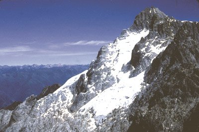
The soul of Sierra Nevada National Park is its high summits, the highest in Venezuela. Pico Bolívar, at close to 4,978 meters, is the roof of the country and the park's symbol. Beside it rise Pico Humboldt (which held the last remnants of glacier in Venezuela), Pico Bonpland and Pico La Concha, among others, forming an imposing massif of rock and altitude. These summits are the great objective of Venezuelan mountaineering. Climbing them requires experience, technical equipment, acclimatization and specialist guides, since it involves rocky terrain, exposed sections and the risks inherent to the high mountains. They are not destinations for casual tourism but alpine challenges that demand serious preparation. For most visitors, these peaks are admired from Pico Espejo (reached by the cable car) or from lookouts and páramos in the park, without attempting the summit. That's the way to admire the grandeur of the Sierra Nevada without taking on mountaineering risks. Best time: dry season, early morning and clear days, since clouds usually cover the summits as the day goes on. For any ascent, always with guides and with an assessment of conditions at the time.
ℹ️ Distance: The park's central massif, above Mérida · Best time: Dry season, morning and clear days · Admission: Viewing from Pico Espejo: included in the cable car ticket (see that entry); mountaineering ascents with guides and equipment, expedition rates separate (US$ 300-600 per person, 3-5 days, verified July 2026; confirm with agencies) · Duration: Viewing: hours; ascents: several days
2
Pico Espejo and the cable car (access to the high mountains)
The highest station on the Mérida cable car, the accessible way into the park's high mountains.
Pico Espejo, at around 4,765 meters, is the final station of the Mérida cable car (Mukumbarí) and the most accessible way into the high mountains of Sierra Nevada National Park without being a mountaineer. In a little over an hour, the cable car climbs from the city of Mérida to this point, crossing the park's different tiers: forest, cloud forest, páramo and high mountain. From Pico Espejo, on a clear day, you take in the park's great peaks, including Pico Bolívar, and a genuinely striking panorama of the range. It's a key point in the park: it lets any visitor, with due care for the altitude, experience the Venezuelan high mountains up close. At this height, altitude sickness (soroche) is real: go up acclimatizing at the intermediate stations, move slowly, wrap up very well and watch out for solar radiation. The cable car runs Wednesday to Sunday (ticket office 7:30 to 13:00) and can close for maintenance or weather, so checking that it's running is essential. Best time: dry season and early morning for the best views.
ℹ️ Distance: The final station of the Mérida cable car, inside the park · Best time: Dry season and early morning; check that the cable car is running · Admission: US$ 20 adults, US$ 15 children/seniors (residents, verified July 2026); US$ 40 for non-resident foreigners; parking US$ 2 (check the rates when you visit, ticket office Wed-Sun 7:30-13:00) · Duration: Most of the day (there and back, with stops)
3
The páramos and the frailejones
The emblematic high-altitude ecosystem, with its frailejones, its unique flora and its unmistakable light.
The páramo is one of the great treasures of Sierra Nevada National Park: a high-altitude ecosystem above the forest and below the snows, characterized by its frailejones, those plants with velvety leaves and upright bearing that are the symbol of the Venezuelan Andes. Walking through a páramo among frailejones, in the particular light of altitude and the silence of the mountains, is one of the most beautiful experiences the park offers. The páramos also play a fundamental ecological role: they are genuine 'water factories', capable of capturing and storing moisture and feeding the rivers that run down to the valleys. That makes their conservation vital, and it's why they are ecosystems so fragile that they deserve respect: don't step off the trails, don't damage the vegetation and don't leave rubbish. The park has páramos accessible for walks of varying difficulty, many of them possible in a day, and others that form part of longer crossings. Walking them with local guides helps you understand their ecology and their importance. Best time: dry season for better conditions; wrap up well (the páramo is cold and windy), bring sunscreen, water and shelter. Tips: move slowly because of the altitude and respect how fragile the environment is.
ℹ️ Distance: Various páramo sectors within the park, reachable from Mérida · Best time: Dry season; bitter cold and páramo wind · Admission: Inparques registration/permit US$ 3-5 per person (verified July 2026); guided páramo walks US$ 15-30 per person · Duration: From day walks to multi-day crossings
4
The high glacial lagoons
Lagoons of glacial origin between páramos and peaks, the goal of hikes and crossings through the range.
Sierra Nevada National Park is dotted with lagoons of glacial origin, sheets of water the ice left between the páramos and the summits over millennia. These cold, crystalline lagoons are one of the park's great draws and the goal of many hikes and crossings, offering landscapes of serene beauty surrounded by frailejones, rock and mountain. There are lagoons with different approaches: some can be reached on a day walk from points near Mérida, and others form part of longer high-mountain crossings, sometimes combined with a summit climb or an overnight stay. They're ideal places to take in the landscape, rest, take photographs and feel the stillness of altitude. As with everything in the Sierra Nevada, reaching the lagoons takes preparation: the altitude, the cold and the changeable weather make guides and proper equipment advisable, especially on the longer routes. Best time: dry season for better conditions and views; wrap up, bring water and food and respect the environment. Tips: don't underestimate the distances or the altitude, and check the state of the trails with local guides.
ℹ️ Distance: Various lagoons in the park's páramos and high mountains · Best time: Dry season; with acclimatization and guides for the long routes · Admission: Guided day trip US$ 25-40 per person; multi-day crossings US$ 60-120 a day with guide, muleteer and food (verified July 2026, indicative) · Duration: From a day to multi-day crossings
5
Crossing to Los Nevados (isolated Andean village)
The classic mountain route to an Andean hamlet, on foot or by mule, from the Loma Redonda station.
One of the park's most traditional crossings is the one that leads to the village of Los Nevados, an isolated Andean hamlet perched on the mountain, famous for its quiet, its traditional architecture and its setting of páramo and summits. The classic route starts from the Loma Redonda cable car station, already in the middle of the páramo, and descends on foot or by mule over several hours. Reaching Los Nevados means immersing yourself in the most authentic Andean life: a village of cobbled streets, rammed-earth houses, a traditional church and an unhurried pace of life, surrounded by mountains. Many travelers stay the night in its rustic guesthouses to enjoy the place, the starry sky and the contact with the community before heading back. The crossing demands a degree of fitness, warm clothing and, normally, local guides and muleteers who know the route and handle the mules. It's an intense but accessible mountain experience for walkers in good shape, quite different from the technical ascents of the peaks. Best time: dry season, when the trail is in the best condition; wrap up well against the cold at altitude. Tips: organize your return, bring cash and respect the village's customs.
ℹ️ Distance: From Loma Redonda (cable car) to the village of Los Nevados, on foot or by mule · Best time: Dry season; bitter cold at altitude · Admission: Cable car to Loma Redonda + crossing with guide/mules US$ 40-70 per person, full day including the return (verified July 2026, indicative); pack mule US$ 15-25 extra · Duration: Several hours for the crossing; ideally with an overnight stay
6
High-altitude wildlife and flora: spectacled bears and giant frailejones
Home to emblematic Andean species, from the spectacled bear to century-old frailejones.
Sierra Nevada National Park protects exceptional high-altitude biodiversity, led by the oso frontino or spectacled bear (Tremarctos ornatus), South America's only bear and a threatened species that lives in the park's cloud forests and páramos. You may also come across deer, pumas, páramo foxes and a great variety of birds, including hummingbirds adapted to life at altitude. The park's flora is equally notable: frailejones, some of them large and of considerable age, carpet the páramos with their characteristic bearing, alongside an enormous diversity of endemic plants adapted to the cold, the radiation and the wind of the high mountains. The cloud forests in the park's lower zones add another layer of biodiversity, with mosses, ferns and orchids. Exploring the park with specialist nature guides lets you learn about these fragile ecosystems and improves the chances of sightings, though the spectacled bear, being so elusive, rarely shows itself. Best time: dry season, with wildlife most active at dawn and dusk. Tips: binoculars, silence, patience and guides certified in wildlife observation.
ℹ️ Distance: Throughout the park, from cloud forest to high páramo · Best time: Dry season; dawn and dusk for wildlife · Admission: Wildlife and plant watching trip with a guide US$ 20-35 per person (verified July 2026, indicative) · Duration: Half a day to a full day
Advertisements
What nobody tells you

💵 Prices

Tickets

TypePrice
Inparques registration/permit to enter the parkUS$ 3-5 per person (verified July 2026; confirm when you visit)
Mérida cable car (Mukumbarí) to Pico Espejo, general/residentsUS$ 20 adults; US$ 15 children (3-12) and seniors (verified July 2026)
Mérida cable car — rate for non-resident foreignersUS$ 40 per person (verified July 2026; confirm at the ticket office)
Cable car VIP seat (2 people + cocktails and wifi)US$ 65 (verified July 2026)
Guided walks and crossings (lagoons, páramos, Los Nevados)US$ 25-70 per person depending on the route and length (verified July 2026)
Mountaineering ascents of the great peaks (full expedition)US$ 300-600 per person, 3-5 days, with guides and equipment (verified July 2026, experienced mountaineers only)
🔄 updated monthlyOfficial / reference values · double-check when buying

Activities and tours

ActivityPriceDurationOperator
Riding the cable car up to Pico EspejoUS$ 20 (residents) / US$ 40 (foreigners); VIP US$ 65 (verified July 2026)Most of the dayMérida cable car / Mukumbarí (official)
Trekking through the páramo and to the glacial lagoonsUS$ 25-40 per person for a day; US$ 60-120/day on long crossings (verified July 2026)1 to several daysMérida mountain guides
Crossing to Los Nevados (on foot or by mule)US$ 40-70 per person, full day (verified July 2026)Several hours / overnightLocal guides and muleteers
Mountaineering ascents of the high peaks (Bolívar, Humboldt)US$ 300-600 per person, 3-5 day expedition (verified July 2026)Several daysMérida high-mountain guides
Watching páramo flora and Andean wildlifeUS$ 15-25 per person with a naturalist guide (verified July 2026)VariableNature guides
🔄 updated monthlyOfficial / reference values · double-check when buying
Advertisements

🚌 How to get there and distances

Getting around

ModePriceDurationNotes
Mérida cable car (Mukumbarí) — the vertical 'shuttle' into the parkUS$ 20 residents / US$ 40 foreigners; children (3-12) and seniors US$ 15; VIP US$ 65-70; parking US$ 2 (source: the cable car's own site, Notitarde and Flightepic, verified July 2026)Most of the dayThis is the direct access to the park's high mountains, up to Pico Espejo (4,765 m). It runs Wednesday to Sunday (ticket office from 7:30; check the days and times, since it closes for maintenance or weather). Tickets are bought online or at the ticket office on the day subject to availability, and up to a month in advance
How urban transport and the bus are paid for (payment methods)Cash (bolívares and dollars) and pago móvilIn the city of Mérida the Trolmérida/TROMERCA mass transit system (trolleybus + Trolcable, the urban cable car) and the minibuses charge the fare —indexed to the dollar, around US$ 0,25— in CASH in bolívares or by pago móvil; there is no widespread rechargeable card. Guides, mules, transfers and mountain guesthouses are paid in cash (bolívares or dollars in small bills) or by pago móvil. Up on the páramo there are no ATMs and no card terminals: go up with enough cash (verified July 2026)
Route and location app (real time)FreeFor getting around the city of Mérida, people use Google Maps; Moovit partially covers the urban lines and the Trolmérida. For the mountain routes (transfers to trailheads, crossings) there is NO tracking app: it's arranged with the agency or the muleteer. Use Google Maps for distances in the valley and check the cable car's status and the weather before heading up (verified July 2026)
Jeep/taxi transfers to the trailheads + mules and guidesTransfer US$ 10-25 per trip; mule US$ 15-25 a day; mountain guide US$ 30-60 a day (source: Mérida agencies and muleteers, verified July 2026)VariableJeeps, taxis or agency transport take you to the starting points for walks and crossings; on routes such as Los Nevados you add pack mules and guides. They're arranged in Mérida, with price and timing agreed in advance, and paid in cash or by pago móvil
🔄 updated monthlyOfficial / reference values · double-check when buying

How to get there

RouteAirlines / operatorsAvg. priceDuration
Getting to Mérida (the park's base)Intercity buses (Expresos Los Llanos and similar) and Conviasa/Laser flights subject to availabilityBus from Caracas US$ 15-30; flight from US$ 60-90 (verified July 2026)Bus: 10-12 h; flight: about 1 h
Mérida -> Pico Espejo by cable carMérida cable car (Mukumbarí)US$ 20-40 depending on the rate (verified July 2026)Most of the day
Mérida -> trailheads for walks and crossingsAgency transfers and local transportUS$ 10-25 per transfer (verified July 2026)Variable
Caracas / Valencia -> Mérida on the Andean highwayIntercity bus companiesUS$ 15-30 approx. (verified July 2026)10 to 12 hours of Andean travel
🔄 updated monthlyOfficial / reference values · double-check when buying

🏨 Where to stay

No exact prices: a scale from $ (budget) to $$$$$ (luxury), with 2-3 options per category.

CategoryPriceRecommended options
Budget lodging / hostels in Mérida$$$$$US$ 13-25 a night; budget hostels and guesthouses downtown, heavily used by nature travelers
Mid-range hotels and guesthouses in Mérida$$$$$US$ 25-45 a night; e.g. Hotel Posada Aurora, Hotel Santa Lucía, a comfortable base for exploring the park
Rustic lodging in Los Nevados$$$$$US$ 15-30 a night; the isolated village of Los Nevados offers rustic, simple guesthouses, bitterly cold and full of Andean charm
High-altitude camps (crossings and ascents)$$$$$Included in the guided expedition package (US$ 300-600 in total); tents and high camps for long crossings and ascents. Extreme conditions; only with proper preparation

🍴 Where to eat

TypePriceOptions / signature dish
Venezuelan Andean cooking (trout, pisca andina)$$$$$US$ 6-15 a dish; trout fried, grilled or stuffed, pisca andina, Andean arepas and high-altitude coffee in Mérida and the villages of the range
Home cooking at the guesthouses$$$$$US$ 5-10 for a full meal; the guesthouses in the range and in Los Nevados usually serve generous home cooking. Worth asking whether meals are included
Supplies and trail food$$$$$US$ 20-35 per person/day if arranged with the guides; for walks and crossings, bring supplies from Mérida, since there are no services at altitude
Advertisements

📖 History of Parque Nacional Sierra Nevada

Origins, formation and what the sources say.

The Sierra Nevada de Mérida: Venezuela's highest massif

Sierra Nevada National Park protects the heart of the Sierra Nevada de Mérida, the highest mountain massif in Venezuela, in the Andean range running down the west of the country. This is where the country's highest summits are concentrated, led by Pico Bolívar (close to 4,978 meters), alongside Pico Humboldt, Pico Bonpland, Pico La Concha and Pico El Toro, among others.

This landscape is the result of Andean geology and of the work of ice over millennia. The old glaciers carved valleys, left lagoons of glacial origin and sculpted the shapes of the high mountains. Above the forest stretches the páramo, a high-altitude ecosystem characteristic of the northern Andes of South America, with its frailejones and its unique flora, adapted to cold and the intense radiation of altitude.

The Sierra Nevada isn't just a geographical feature but a world of ecological bands shifting with altitude: from mountain forest to cloud forest, from there to páramo and finally to the rock and ice of the summits. That diversity, compressed into a relatively small space, makes the range a place of enormous natural value, and explains why it was decided to protect it with a national park.

Glacial origin of the landscape
The geography of the Sierra Nevada de Mérida, with its valleys, lagoons and summit forms, is largely attributed to the action of ancient glaciers. The high páramo is an ecosystem characteristic of the northern Andes. The geological details and the glacial chronology rest on scientific studies.
Source: https://es.wikipedia.org/wiki/Sierra_Nevada_de_M%C3%A9rida

Andean peoples, colonization and life in the mountains

Long before the park was created, the Sierra Nevada and its surroundings were the territory of Andean peoples. The Indigenous communities of the Venezuelan Andes lived in the valleys and on the slopes of the range, farming terraces, raising animals and adapting to life at altitude. The region's place names still carry traces of that Indigenous presence.

With the arrival of the Spanish and the founding of Mérida in the 16th century, the region joined the colonial world. In the valleys and on the lower slopes a mestizo Andean life developed, with mountain villages, high-altitude farming, livestock and a culture of its own, shaped by the cold climate, the relative isolation and religion. Villages such as Los Nevados, perched high in the mountains, are testimony to that colonization of the heights.

For centuries the high mountains were above all a place of passage, grazing and legend rather than permanent settlement on the summits. The relationship of the Andean communities with the range was mediated by the harshness of the climate and the altitude. That long history of human life in the mountains is part of the park's context: when the protected area was created, this was not empty territory but a landscape inhabited and used by generations of Andean people.

Andean occupation before the park
The Sierra Nevada region was inhabited by Andean peoples before the conquest and later by mestizo communities after Spanish colonization, with mountain villages such as Los Nevados. Details about specific Indigenous groups and their organization rest on historical and archaeological studies of the Venezuelan Andes.
Source: https://es.wikipedia.org/wiki/Estado_M%C3%A9rida

The cradle of Venezuelan mountaineering: the first ascents

In the early 20th century, the Sierra Nevada de Mérida became the cradle of Venezuelan mountaineering. The high summits, previously untouched, began to attract explorers and climbers who saw in them the country's great mountain challenge. The first ascents of the major peaks were founding milestones for national alpinism.

The highest summit, Pico Bolívar, was one of the great objectives, and its first documented ascent is usually placed around the mid-1930s, associated with mountaineers such as Enrique Bourgoin, according to the most widespread sources. The other great summits, such as Humboldt and Bonpland, were also conquered, in a period when Venezuelan Andean mountaineering was taking shape as a discipline and as a community.

In time Mérida established itself as the mountaineering capital of Venezuela: a city with clubs, guides and a high-mountain tradition, from which the expeditions into the range were organized. The national park, created in 1952, came to protect that setting and regulate the activities. To this day the Sierra Nevada remains the central destination for Venezuelan alpinism, and its peaks the great objectives for anyone climbing in the country.

The first ascents of the early 20th century
Sources place the birth of Venezuelan mountaineering in the Sierra Nevada de Mérida in the early 20th century, with the conquest of the great peaks (the first ascent of Pico Bolívar is usually dated to around 1935, linked to Enrique Bourgoin). Dates, routes and protagonists vary from source to source.
Source: https://es.wikipedia.org/wiki/Pico_Bol%C3%ADvar

The creation of Sierra Nevada National Park (1952)

In 1952 the Venezuelan state created Sierra Nevada National Park, one of the country's first national parks. The decision answered the need to protect an exceptional ecosystem: the high-summit massif of Mérida, with its páramos, its glacial lagoons, its forests and Venezuela's only glaciers, against the pressures of human expansion and uncontrolled use of the land.

The park's creation put the country's highest peaks under legal protection, Bolívar included, along with a set of ecological bands of enormous value. It set rules for access and activities, seeking to reconcile conservation with tourism and mountaineering. Over the years the park joined the system of protected areas run by Venezuela's environmental authorities (today through Inparques).

That framework was key to preserving the Sierra Nevada as a natural space. It allowed later generations to enjoy its landscapes and kept the biological richness of the páramos, which are also essential as water sources. The park's protection turned the Sierra Nevada into recognized natural heritage, the foundation of the nature travel and mountaineering that are now hallmarks of Mérida and the Venezuelan Andes.

One of the country's first national parks (1952)
Sources agree that Sierra Nevada National Park was created in 1952, among Venezuela's first, to protect the high-summit massif of Mérida. It is the legal framework that now regulates access and activities in the area, administered by the environmental authorities (Inparques).
Source: https://es.wikipedia.org/wiki/Parque_nacional_Sierra_Nevada_(Venezuela)

The glaciers, climate change and the conservation challenges

One of the most dramatic chapters in the park's recent history is that of its glaciers. The Sierra Nevada de Mérida held Venezuela's only glaciers, on the highest summits, among them Pico Bolívar and Pico Humboldt. Those ice fields, which crowned the mountains through the 20th century, were a distinctive feature of the Venezuelan Andean landscape.

Over recent decades, global warming caused an accelerated retreat of those glaciers. The ice disappeared from the summits until it was reduced to minimal fragments; the one on Pico Humboldt is usually cited as the country's last glacier. Venezuela came to be listed among the territories that have lost their glaciers in recent times, a symbol of the impact of climate change on tropical high mountains.

This process transformed the park's landscape, changed the conditions for mountaineering (where there was ice, there is now rock) and even altered the measured heights of the peaks. It is also a reminder of the conservation challenges the Sierra Nevada faces: alongside climate change, the park has to deal with tourist pressure, vegetation fires and the need to protect the fragile páramos, the water sources for the whole region. The park's history thus connects the natural grandeur of the Venezuelan Andes with the great environmental concerns of the present.

The disappearance of Venezuela's glaciers
Sources document that the Sierra Nevada de Mérida held Venezuela's only glaciers and that they retreated drastically because of climate change until they all but disappeared (the one on Pico Humboldt is usually cited as the last). The exact dates of their definitive 'disappearance' vary according to criteria and studies.
Source: https://es.wikipedia.org/wiki/Glaciares_de_Venezuela

📚 Bibliography

  • Wikipedia (ES) — «Parque nacional Sierra Nevada (Venezuela)»: https://es.wikipedia.org/wiki/Parque_nacional_Sierra_Nevada_(Venezuela)
  • Wikipedia (ES) — «Sierra Nevada de Mérida»: https://es.wikipedia.org/wiki/Sierra_Nevada_de_M%C3%A9rida
  • Wikipedia (ES) — «Pico Bolívar»: https://es.wikipedia.org/wiki/Pico_Bol%C3%ADvar
  • Wikipedia (ES) — «Pico Humboldt»: https://es.wikipedia.org/wiki/Pico_Humboldt
  • Wikipedia (ES) — «Glaciares de Venezuela»: https://es.wikipedia.org/wiki/Glaciares_de_Venezuela
  • Wikipedia (ES) — «Estado Mérida»: https://es.wikipedia.org/wiki/Estado_M%C3%A9rida
  • Wikipedia (ES) — «Los Nevados (Mérida)»: https://es.wikipedia.org/wiki/Los_Nevados_(M%C3%A9rida)
  • Inparques — Parques Nacionales de Venezuela: https://www.inparques.gob.ve/

❓ Frequently asked questions

What does Sierra Nevada National Park protect?+
It protects the most important high-summit massif in Venezuela, in the Mérida Andes, including Pico Bolívar (the country's highest) and Pico Humboldt and Pico Bonpland, along with frailejón páramos, glacial lagoons, mountain forests and rich wildlife. It was created in 1952, one of the country's first national parks.
How much does the cable car cost?+
The general rate (residents) is US$ 20 for adults and US$ 15 for children aged 3 to 12 and seniors; non-resident foreigners pay US$ 40. There are VIP seats for 2 people with cocktails and wifi at around US$ 65-70. Parking costs US$ 2 (verified July 2026; source: the cable car's own site, Notitarde and Flightepic). You pay in cash (bolívares or dollars) or by pago móvil. Check the current rate when you visit, since it moves with the exchange rate.
Do you have to be a mountaineer to visit it?+
Not necessarily. There are options at every level: riding up to Pico Espejo on the cable car (accessible), day walks to páramos and lagoons (US$ 25-40), or multi-day crossings and ascents for mountaineers (US$ 300-600 on a guided expedition). The great peaks, such as Bolívar, do require experience, equipment and guides.
How does the altitude affect you in the park?+
A great deal: much of the park is at high altitude, and soroche (altitude sickness) is real, especially near Pico Espejo (almost 4,800 m). Acclimatize gradually, move slowly, drink water, wrap up and, for the demanding routes, use guides. Anyone who feels unwell should descend.
When is the best time to go?+
The dry season (roughly December to March) brings clearer skies, better views and more stable conditions. Even so, high-altitude weather changes fast all year. In the rainy season the landscape is greener but hiking gets harder and the views close in. For long crossings, plan with guides.
Is it true the park lost its glaciers?+
Yes. The Sierra Nevada de Mérida held Venezuela's only glaciers, on its highest summits (Pico Bolívar, Pico Humboldt). Global warming shrank them drastically over recent decades until they all but disappeared, a phenomenon that changed the high-altitude landscape and turned the park into an eloquent witness to climate change.
Sources consulted (14)
Still planning?
Explore more destinations in Venezuela
See all destinations →
Advertisements
Image credits
Photos from Wikimedia Commons, each under its own licence (CC BY, CC BY-SA or public domain). Open each file to see its author and licence.
Bolívar usgs