Viajá con Gus
Home › Sudan › Meroe Pyramids (Begrawiya)
Meroe Pyramids (Begrawiya)
🇸🇩 Sudan · The Kingdom of Kush: the pyramids of Meroe

Meroe Pyramids (Begrawiya)

🪪 What do I need to enter Sudan?Pick your citizenship and we tell you the visa, the days and the paperwork, with the official source.

By leaving your email and citizenship you agree to receive the documents you asked for and weekly travel news. You can unsubscribe whenever you want. How we handle your data.
Jump to what you need
📌Safety warning
SUDAN HAS BEEN IN A CIVIL WAR SINCE 15 APRIL 2023 between the Sudanese Armed Forces and the Rapid Support Forces. Access to the site is suspended and there are no organised visits. ALL foreign ministries advise against travel to the whole of Sudan: the US keeps its Level 4 “Do Not Travel” advisory (renewed on 15 May 2026), the British Foreign Office keeps its most severe warning and has had no diplomatic presence in the country since April 2023, and Spain's Ministry of Foreign Affairs advises against travel under any circumstances. THERE IS NO TOURISM OPERATING. This page is an informational and heritage guide, not an invitation to travel.
📌What it is
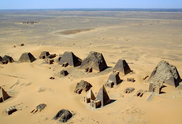
The royal necropolis of Meroe, the southern capital of the Kingdom of Kush, with more than two hundred pyramids spread across three cemeteries (North, South and West) on the dunes of the east bank of the Nile. These are Nubian pyramids: much smaller and much steeper than the Egyptian ones, with sides angled between 60 and 70 degrees, bases just a few metres wide and a funerary chapel attached to the east face. It is the largest group of pyramids in the world: there are more pyramids in Sudan than in Egypt.
📌Location
In River Nile State, about 200 kilometres northeast of Khartoum and about 6 kilometres northeast of Kabushiya station, near Shendi. The present-day village next to the site is Begrawiya (al-Bajrawiya), the name by which the necropolis is popularly known. The site lies between the fifth and sixth cataracts of the Nile, on the edge of the Butana desert.
📌World Heritage Site
The “Archaeological Sites of the Island of Meroe” were inscribed by UNESCO on the World Heritage List in June 2011. The property has three components: the city and necropolises of Meroe, the temple complex of Naqa and the complex of Musawwarat es-Sufra. It is one of Sudan's two sites on the List, together with Jebel Barkal and the Sites of the Napatan Region (2003).
📌Timeline
The Kingdom of Kush spans roughly from the 8th century BC to the 4th century AD. The capital moved from Napata to Meroe around 591 BC, under King Aspelta, after the Egyptian sack of Napata. The pyramids of the Meroe necropolis were built over some six and a half centuries, roughly between 300 BC and AD 350, when the city collapsed.
📅Climate
Hot and extreme desert climate. April to June and September are scorching, with highs often above 42-45 °C; winter, from November to February, is mild by day and cool at night, with big temperature swings in the desert. Rain is very scarce and falls between July and September, which is also the sandstorm season. Under normal conditions, the sensible window would be November to February.
📌State of the site
The pyramids of Meroe have not been directly hit by the fighting, thanks to their distance from the main fronts in Khartoum, Kordofan and Darfur. The problem is a different one: the collapse of the system of guarding and maintenance. Graffiti on the walls and blocks dislodged by unsupervised visitors climbing the structures have been documented. UNESCO activated its Heritage Emergency Fund for Sudan's two World Heritage sites and warned about the illicit trafficking of antiquities from the country.
📌Suggested duration
Not applicable. There are no tours operating. As a pre-war reference, a visit to the Begrawiya site took half a day, and the classic circuit that combined it with Naqa and Musawwarat es-Sufra needed two or three days by 4x4 from Khartoum.
💱 SDG exchange rate
Loading rate…
🌤️ Weather in Meroe Pyramids (Begrawiya)
Loading weather…

There are more pyramids in Sudan than in Egypt, and most of them are here. In the royal necropolis of Meroe, two hundred kilometres northeast of Khartoum, more than two hundred pyramids rise from a sea of golden dunes in three separate cemeteries. They look nothing like the ones at Giza: they are much smaller and much steeper, with sides angled between 60 and 70 degrees that make them look like spires, and a funerary chapel attached to the east face where the deceased received offerings. The image — rows of sharp pyramids on the sand, without a single soul around — is Sudan's most iconic postcard.

Meroe was the southern capital of the Kingdom of Kush for almost a thousand years, from when King Aspelta moved the court there around 591 BC until the city collapsed in the 4th century AD. It was a powerful and original African state: it created its own script, Meroitic, which can still be read today but is not fully understood; it produced iron on a scale that earned it the nickname “the Birmingham of Africa”; it was ruled by queens with power of their own, the kandakes; and it stood up to the Roman Empire in the 1st century BC under Queen Amanirenas.

This guide does not suggest a trip. Sudan has been at war since April 2023 and every foreign ministry advises against any travel to the country; access to the site is suspended. What follows is an informational and heritage guide: what Meroe is, what you can see in each of its sectors, what history it tells and what state it is in today, with the available and verifiable information on the damage suffered by Sudan's heritage.

📖 History of Meroe Pyramids (Begrawiya)

Meroe was the second great capital of the Kingdom of Kush. Around 591 BC, after the Egyptian sack of Napata, King Aspelta moved the centre of power some four hundred kilometres south, to a spot between the fifth and sixth cataracts that combined three decisive advantages: summer rains reached it, iron ore and hardwood were plentiful, and it lay on the route to the Red Sea. There the kingdom flourished for almost a thousand years, developed its own script, produced iron on an industrial scale and was ruled by kings and by queens with power of their own, the kandakes. Under Amanirenas, around 25-22 BC, the Kushites attacked Roman Egypt and went as far as sacking Aswan; the prefect Petronius struck back and razed Napata, but the conflict ended in a treaty on terms favourable to Meroe that secured almost three centuries of peace. The city went into decline from the 3rd century AD and collapsed around AD 350, in a process that involved a campaign by the Aksumite king Ezana, although it is now debated whether that was a cause or a consequence of the decline. Its pyramids were rediscovered by Europeans in the 19th century and plundered in 1834 by Giuseppe Ferlini, who dismantled dozens of tops looking for treasure.

Read the full history ↓

🏛️ Meroe Pyramids (Begrawiya) is in the kingdom of Kush: the pyramids of Meroe

The Butana steppe holds more than two hundred pyramids, a temple to the lion god and a maze of courtyards and elephants: the heart of the kingdom that smelted iron and wrote in an alphabet we still cannot translate.

Read the history of The kingdom of Kush: the pyramids of Meroe →

🗺️ What to see

1
Northern Cemetery (Begrawiya North)
The most spectacular sector and the one in every photo: some forty pyramids lined up along a sandy ridge, most of them belonging to kings and queens of the late Meroitic period. This is where pyramid N6 of the kandake Amanishakheto stood; Giuseppe Ferlini blew off its top in 1834 to carry away the treasure of gold jewellery that is now divided between Berlin and Munich. Several pyramids were partly restored in the 20th century and show their original profile.
2
Southern Cemetery (Begrawiya South)
The oldest of the three, with the tombs of the first rulers buried at Meroe when the court still alternated with Napata. Its pyramids are much more ruined and smaller, but they document the moment when royal burial practice moved south for good.
3
Western Cemetery
The cemetery of the non-ruling members of the royal family and of the Meroitic elite, with hundreds of tombs of varied types. It is the least monumental but the most revealing about Meroitic society: here you see the full scale of the kingdom's funerary hierarchy.
4
The funerary chapels and their reliefs
Each pyramid had a small chapel with an entrance pylon attached to its east face, where offerings were left. Their walls keep reliefs with offering scenes, processions, Meroitic texts and depictions of the dead: kings wearing the Kushite cap and full-figured queens who are one of Meroe's iconographic hallmarks. Several of these reliefs were removed in the 19th century and are now in European museums.
5
The Royal City
About three kilometres from the necropolises, next to the Nile, lie the remains of the city itself: the walled palace enclosure, administrative buildings and the urban layout of the capital. It is the least eye-catching part and the most important for understanding that Meroe was not a cemetery but a metropolis with thousands of inhabitants.
6
Temple of Amun at Meroe
The city's great sanctuary, dedicated to the god who legitimised the Kushite rulers, with a processional avenue and an architectural plan inherited from Egypt but reinterpreted locally. Devotion to Amun was the thread that tied Napata and Meroe together for a thousand years, with Jebel Barkal as a permanent theological reference.
7
Temple of the Sun (the so-called “Royal Baths”)
A unique complex east of the Royal City, with a pool, relief decoration and features that mix Kushite tradition with Hellenistic and Roman influences. Its function is debated: it has been interpreted as a ritual water complex linked to worship and as a palace leisure space. It is the building that best shows Meroe's connection with the Mediterranean.
8
The iron workshops and the slag heaps
Huge mounds of smelting slag pile up around the city, evidence of iron production on a scale that led archaeologist A. H. Sayce to call Meroe “the Birmingham of Africa”. That metal — for weapons, tools and trade — was one of the foundations of the kingdom's power, along with ivory, ebony, gold and cattle.
9
Meroitic inscriptions
Meroe developed its own script around the 3rd century BC, in two forms: a hieroglyphic one for religious and monumental use and a cursive one for administration. It has twenty-three signs and has been readable phonetically since the work of Francis Llewellyn Griffith in the early 20th century, but the language it records remains largely undeciphered. The oldest known inscription dates from between 180 and 170 BC, in the temple of Queen Shanakdakhete.
10
The dune landscape of the Butana
The site stands on the edge of a sea of golden dunes in the semi-arid savannah of the Butana, with scattered acacias and a clean horizon. That setting — the sand creeping up the bases of the pyramids, the low light of sunrise and sunset — is an essential part of what makes Meroe one of the most photogenic archaeological sites in the world.
11
Ferlini's mark
A walk through Meroe is also a walk through the history of archaeological plunder. In 1834 the Italian doctor Giuseppe Ferlini dismantled the tops of dozens of pyramids looking for hidden treasure chambers; he found the gold grave goods of Amanishakheto and irreversibly mutilated the profile of the site. Many of the truncated tops you see today are his work, and the treasure he took is in the Neues Museum in Berlin and in Munich.
12
The Nile and the northern archaeological route
Meroe is the southern gateway to Sudan's great archaeological route that follows the Nile north: Naqa and Musawwarat es-Sufra in the Butana, Atbara and the Bayuda desert, and then Jebel Barkal, Nuri, El Kurru and Kerma in the Napatan region. It is the full sequence of three thousand years of Nubian civilisation, and today it is entirely inaccessible.
📶I have never landed without internet. I arrive and my phone connects to the strongest network in the country I am visiting: I can say I landed, sort out transport, book tours and keep posting, at a seriously good price. I always use the Maya eSIM — check their plans by clicking the banner.See plans →Maya Mobile eSIM — download, install, go
What nobody tells you

💵 Prices

Tickets

TypePrice
Situación generalTHERE ARE NO TICKET SALES AND NO ORGANISED VISITS. The site cannot be reached safely and the National Corporation for Antiquities and Museums (NCAM) does not run a verifiable visitor service. No current rates are published (2026)
Referencia histórica previa a la guerraBefore April 2023, travel guides mentioned an entry fee to the site of around 10-20 USD per person, with considerable variation and no stable official publication. It is quoted only as a historical reference: it is NOT a current or verifiable price
Referencia histórica — permisosSudan's pre-war administrative framework required travellers to register after arrival, a photography permit obtained from the Ministry of the Interior and a travel permit for trips of more than about 25 km from Khartoum, which had to be obtained before setting off for Meroe. Historical information, with no practical validity today
🔄 updated monthlyOfficial / reference values · double-check when buying

Activities and tours

No tourist activities operating
Not applicable
DurationNot applicable
Operator
No operators are working at the site under verifiable conditions. The 4x4 tours from Khartoum combining Meroe, Naqa and Musawwarat es-Sufra were suspended in April 2023 and no resumption has been documented. The tourist camp that operated next to the necropolis has no verifiable activity either (2026)
🔄 updated monthlyOfficial / reference values · double-check when buying

🚌 How to get there and distances

Getting around

No verifiable tourist transport operating
Not applicable
DurationNot applicable
Notes
Reaching the site required your own or a hired vehicle from Khartoum or Shendi; today there is no verifiable service and no safe conditions for the journey. The Khartoum-Atbara road passes relatively close to the site, but the country's roads are subject to checkpoints, closures and risks arising from the conflict (2026)
🔄 updated monthlyOfficial / reference values · double-check when buying

How to get there

Khartoum → Meroe (Begrawiya)
Not applicable
Airlines / operatorsNot applicable
Duration
About 200 km northeast of Khartoum on the road to Atbara; before the war, roughly a three-hour drive. Today the journey cannot be made with any guarantee of safety
Shendi / Kabushiya → site
Not applicable
Airlines / operatorsNot applicable
Duration
The necropolis is about 6 km northeast of Kabushiya station, near Shendi. No verifiable transport service
Air access to the country
No stable fares published
Airlines / operatorsBadr Airlines, Tarco Aviation, Sudan Airways
Duration
Khartoum International Airport reopened to domestic flights on 22 October 2025 and to regular commercial flights at the end of January 2026, with intermittent operations. The reopening does not change the advice not to travel
🔄 updated monthlyOfficial / reference values · double-check when buying

🏨 Where to stay

No exact prices: a scale from $ (budget) to $$$$$ (luxury), with 2-3 options per category.

No verifiable accommodation on offer
Price$$$$$
Recommended options
No prices or establishments are published. Before the war there was a tented camp next to the necropolis and some basic lodgings in Shendi and Atbara; there is no verifiable information on whether they are operating now, and they should not be presented as available options (2026)

🍴 Where to eat

Sin oferta gastronómica verificable
Price$$$$$
Options / signature dish
No prices or venues are published. The site is in a rural area with no tourist services operating, and Sudan is going through a severe food crisis documented by the United Nations (2026)

📖 History of Meroe Pyramids (Begrawiya)

Origins, formation and what the sources say.

Before Meroe: Kerma, Napata and the Black Pharaohs

The story of Meroe begins long before Meroe existed. Around 2500 BC, in Upper Nubia, the kingdom of Kerma flourished. It was the first great state in Sudan, with a capital of tens of thousands of people and huge mud-brick buildings called deffufas. Kerma became a rival to Egypt and controlled the Nile valley between the cataracts, until the pharaohs of the New Kingdom conquered it around 1500 BC and annexed Nubia under a viceroy, the “King's Son of Kush”.

When Egyptian power fell apart after 1070 BC, Nubia won back its independence and a new kingdom arose around Napata, at the foot of the sacred mountain of Jebel Barkal, believed to be the home of the god Amun. That kingdom did something extraordinary: in the 8th century BC it reversed the course of history and conquered Egypt. Kashta reached Thebes, and his successor Piye completed the conquest of the Delta around 727 BC, founding the 25th Dynasty, the so-called “Black Pharaohs”. Piye, Shabaka, Shabataka, Taharqa and Tanutamani ruled an empire that stretched from the Mediterranean to present-day Khartoum.

The empire lasted little more than half a century. The Assyrians under Esarhaddon and Ashurbanipal invaded Egypt between 671 and 663 BC, took Memphis, sacked Thebes and drove the Kushites south. Taharqa died at Napata in 664 BC and was buried beneath the first pyramid at Nuri. The Kushite kings went on ruling their own kingdom, which looked more and more to the south and to the African interior.

The final blow to Napata came around 593 BC, when an expedition sent by the Egyptian pharaoh Psamtik II sacked the city. Shortly afterwards, under King Aspelta and around 591 BC, the kingdom's centre of gravity moved for good some four hundred kilometres south, to Meroe.

en.wikipedia.org · Kingdom of Kushen.wikipedia.org · Twenty fifth Dynasty of Egypt

Why Meroe: the geography of a capital

The move to Meroe was not a retreat. It was an excellent strategic decision. The new site lay between the Fifth and Sixth Cataracts of the Nile, on the edge of the Butana steppe, and it offered three advantages that Napata lacked.

The first was rain. Meroe lies far enough south to get the summer monsoon rains, which allowed rain-fed farming and large-scale herding beyond the narrow irrigated strip along the Nile. That greatly widened the kingdom's economic base and made it partly independent of the flood.

The second was iron ore and hardwood. The region had iron deposits and acacia woodland that supplied the charcoal needed to smelt it. Meroe became a major metalworking centre: the slag heaps around the city led the archaeologist A. H. Sayce to call it “the Birmingham of Africa”. Iron provided weapons, farming tools and a trade good for export.

The third was its position for trade. Meroe sat at the start of the routes that crossed the Butana towards the Red Sea and the Horn of Africa, and it also controlled the Nile. Ivory, ebony, exotic skins, ostrich feathers, gold, copper and cattle all passed through it. On top of this trade came cotton textile production, which peaked around 400 BC.

The result was a state that survived for almost a thousand years and became steadily more African in character. Egyptian gods lived alongside local deities such as Apedemak, the lion-headed war god; the Kushite language replaced Egyptian in writing; and royal imagery developed a visual language of its own, with kings in caps with tassels and full-figured queens that look like nothing Egyptian.

en.wikipedia.org · Meroëen.wikipedia.org · Kingdom of Kush

The Meroitic kingdom: writing, kandakes and the struggle with Rome

Around the 3rd century BC, Meroe took a decisive step: it stopped writing in Egyptian hieroglyphs and created its own writing system. Meroitic has twenty-three signs and comes in two forms, a hieroglyphic one for monuments and a cursive one for administration and funerary texts. It is the oldest indigenous writing system in sub-Saharan Africa. Francis Llewellyn Griffith worked out the sound values of the signs in the early 20th century, so the texts can now be read aloud. But the language they record has no clear link to any well-documented language family and, without a long bilingual text, it remains largely untranslated. The oldest known Meroitic inscription dates to between 180 and 170 BC, in the temple of Queen Shanakdakhete.

That queen brings us to another distinctive feature of the kingdom: the political role of women. The title kandake referred to the queen mother, and it was more than an honour. Several women ruled with full authority and appear in reliefs with the same symbols of power as kings, striking down enemies and receiving divine protection. Shanakdakhete, Amanirenas, Amanishakheto and Amanitore are the best known.

The kingdom's most famous episode is its clash with Rome. After Rome annexed Egypt in 30 BC, tension rose along the southern frontier. Around 25 BC, while the legions were busy in Arabia, a Kushite army led by the kandake Amanirenas attacked the Thebaid, sacked Aswan and pulled down the imperial statues at Philae. One of them gave us the famous bronze head of Augustus, which the Kushites carried off and buried beneath the steps of a temple at Meroe so that anyone entering would tread on the emperor. Wallis Budge excavated it in the early 20th century, and today it is in the British Museum.

Rome responded through the prefect Gaius Petronius, who sailed up the Nile and razed Napata in 22 BC. But the war ended at the negotiating table: a Kushite embassy reached Augustus on Samos, and a treaty was signed on surprisingly favourable terms for Meroe, with Rome withdrawing from part of the occupied territory and waiving tribute. The peace that followed lasted around three centuries. In AD 61, Nero sent a scouting expedition that reached Meroe and carried on south until it ran into the swamps of the Sudd. It was the furthest south Rome ever reached in Africa.

The most widely accepted view is that the kandake who fought Rome was Amanirenas, but some authors have suggested Amanishakheto or one succeeding the other. Classical sources speak simply of “Candace”, which was the title, not a personal name.
en.wikipedia.org · Amanirenasen.wikipedia.org · Meroë

The pyramids: form, function and meaning

Nubian pyramids are not small copies of Egyptian ones. They are an architectural type of their own. Their sides rise at angles of between 60 and 70 degrees, compared with about 51 degrees at Giza, which gives them a sharp, almost needle-like profile. Their bases usually measure between 6 and 30 metres per side, and they rarely stand more than 30 metres high. They are built from blocks of local sandstone and, in the later examples, from faced brick.

Each pyramid had a funerary chapel attached to its east face, with a pylon at the entrance, where offerings to the dead were left. These chapels hold the reliefs that are the kingdom's main source of imagery: offering scenes, processions, Meroitic texts, and depictions of the rulers and of the lion god Apedemak. The burial chamber itself was cut into the rock beneath the structure and reached by a staircase. It held cremated or buried remains together with grave goods.

The Meroe necropolis is divided into three cemeteries. The South Cemetery is the oldest, with the tombs of the first rulers buried in the new capital. The North Cemetery, the most spectacular, holds the kings and queens of the classic and late Meroitic period, lined up along a ridge of sand; it is the image everyone associates with Sudan. The West Cemetery contains hundreds of tombs of non-ruling members of the royal family and the elite, and it is the one that best documents the kingdom's social hierarchy.

Across the three cemeteries there are more than two hundred pyramids in total, built over some six and a half centuries, roughly between 300 BC and AD 350. Adding up all of Sudan's pyramid fields (El Kurru, Nuri, Jebel Barkal, Sanam, Zuma and Meroe), the country has far more pyramids than Egypt: there are more pyramids in Sudan than anywhere else in the world.

en.wikipedia.org · Nubian pyramidswhc.unesco.org

The fall, the plunder and the archaeology

Meroe began to decline from the 2nd century AD. The causes are many and still debated: trade competition from Aksum and the Red Sea routes, which shifted the axis of commerce; soil exhaustion and the deforestation caused by centuries of iron smelting; climate changes that affected the summer rains; and pressure from desert peoples. By around AD 300 the archaeological evidence already shows clear impoverishment. The last pyramids and royal burials date to the mid-4th century.

Around AD 340–350, the Aksumite emperor Ezana left a trilingual stela recording expeditions against Kush and against the Noba. For a long time this text was read as the destruction of Meroe by Aksum. Today scholars debate whether Ezana destroyed a living state or simply intervened in ruins that were already falling apart. Either way, the Aksumite occupation was short. From the remains of the Meroitic world rose the kingdoms of Nobatia, Makuria and Alodia, which would become Christian in the 6th century.

European rediscovery began with the French mineralogist Frédéric Cailliaud, who reached the site in 1821 and published the first drawings that brought Meroe to the attention of European scholars. Thirteen years later came disaster: in 1834 the Italian doctor Giuseppe Ferlini dismantled the tops of dozens of pyramids in search of hidden chambers, and in pyramid N6 he found the treasure of the kandake Amanishakheto, an exceptional collection of gold jewellery with fused glass. When he offered it for sale in Europe nobody believed it was genuine. Richard Lepsius authenticated it in 1844 after visiting Meroe. Berlin bought most of the treasure and Ludwig I of Bavaria a smaller part. The truncated tops you see on many pyramids today are Ferlini's work.

Scientific archaeology came later. E. A. Wallis Budge excavated between 1902 and 1905; John Garstang led the University of Liverpool's excavations from 1910 and uncovered the palace and temples of the Royal City; and George Reisner worked in the royal cemeteries for Harvard and the Museum of Fine Arts, Boston. UNESCO added the “Archaeological Sites of the Island of Meroe”, which include Meroe, Naqa and Musawwarat es-Sufra, to the World Heritage List in June 2011.

Why Meroe collapsed is still an open question. The main hypotheses combine the shift of trade towards Aksum and the Red Sea, environmental damage from the deforestation that came with iron smelting, changing rainfall patterns and pressure from nomadic groups. Ezana's campaign is now seen more as the final blow than as the cause.
en.wikipedia.org · Giuseppe Ferlinien.wikipedia.org · Meroë

Meroe today: floods, war and conservation

The 21st century brought new threats to Meroe. In September 2020, the biggest Nile flood recorded in more than a century (the Blue Nile broke the records of 1946 and 1988) brought water close to the necropolis, which normally lies several hundred metres from the river. Teams from the National Corporation for Antiquities and Museums built sandbag walls and pumped out water to hold it back. The head of the French archaeological unit at the Sudanese antiquities service warned at the time that, if the water kept rising, these measures might not be enough. It was the first time in recorded history that flooding had directly threatened the site.

Three years later came war. Since 15 April 2023, the conflict between the Sudanese Armed Forces and the Rapid Support Forces has devastated the country and its heritage. Meroe was relatively lucky: it lay far from the main front lines and was not directly hit by the fighting. The documented damage is of a different kind. The collapse of guarding and maintenance left the site unsupervised, and there have been reports of graffiti on the walls and of blocks dislodged by visitors climbing the structures.

The other two parts of the same UNESCO site fared worse. Naqa and Musawwarat es-Sufra were hit by documented bombardments in January 2024 after armed incursions into the area. Both are now surrounded by military camps and minefields that make conservation and research impossible. Across the country, the 2025 assessment counted more than twenty museums damaged or looted and around 110 million dollars in losses to the culture, antiquities and tourism sector, the worst being the looting of the National Museum of Sudan in Khartoum.

UNESCO described the threat to Sudan's heritage as “unprecedented”. It activated its Heritage Emergency Fund for the country's two World Heritage sites and publicly urged people not to buy antiquities from Sudan after pieces appeared for sale on online platforms. In November 2024 there were seizures and arrests in northern Sudan: figurines, pottery and antique weapons were intercepted at border crossings and people were arrested in Atbara, which confirmed that an active trafficking network exists.

Meroe is still standing, as it has for two thousand three hundred years. But its future now depends on the country regaining the ability to protect it, and that means ending a war that was still unresolved in 2026.

archaeology.org · 200911 sudan meroe floodingen.wikipedia.org · Destruction of cultural heritage during the…

📚 Bibliography

  • UNESCO — “Archaeological Sites of the Island of Meroe” (World Heritage, 2011): https://whc.unesco.org/en/list/1336/
  • Wikipedia (EN) — “Meroë”: https://en.wikipedia.org/wiki/Mero%C3%AB
  • Wikipedia (ES) — “Meroe”: https://es.wikipedia.org/wiki/Meroe
  • Wikipedia (EN) — “Kingdom of Kush”: https://en.wikipedia.org/wiki/Kingdom_of_Kush
  • Wikipedia (EN) — “Nubian pyramids”: https://en.wikipedia.org/wiki/Nubian_pyramids
  • Wikipedia (EN) — “Twenty-fifth Dynasty of Egypt”: https://en.wikipedia.org/wiki/Twenty-fifth_Dynasty_of_Egypt
  • Wikipedia (EN) — “Amanirenas”: https://en.wikipedia.org/wiki/Amanirenas
  • Wikipedia (EN) — “Amanishakheto”: https://en.wikipedia.org/wiki/Amanishakheto
  • Wikipedia (EN) — “Giuseppe Ferlini”: https://en.wikipedia.org/wiki/Giuseppe_Ferlini
  • Wikipedia (EN) — “Meroitic language”: https://en.wikipedia.org/wiki/Meroitic_language
  • Archaeology Magazine — “Floodwaters Threaten Sudan's Ancient Pyramids” (11/09/2020): https://archaeology.org/news/2020/09/11/200911-sudan-meroe-flooding/
  • Al Jazeera — “Sudan floods threaten ancient archaeological site, experts say” (08/09/2020): https://www.aljazeera.com/news/2020/9/8/sudan-floods-threaten-ancient-archaeological-site-experts-say
  • Wikipedia (EN) — “Destruction of cultural heritage during the Sudanese civil war (2023–present)”: https://en.wikipedia.org/wiki/Destruction_of_cultural_heritage_during_the_Sudanese_civil_war_(2023%E2%80%93present)
  • Policy Center for the New South — “Sudan's Heritage: Looting as a Weapon of War”: https://www.policycenter.ma/publications/sudans-heritage-looting-weapon-war

❓ Frequently asked questions

Can the pyramids of Meroe be visited today?+
No. Sudan has been in a civil war since 15 April 2023 and every foreign ministry advises against travel to the whole country. Access to the site is suspended, there are no ticket sales or operators working, and consular assistance is limited or non-existent. Standard travel insurance does not cover areas of armed conflict.
Were the pyramids damaged by the war?+
Not directly. Meroe lay far from the main fronts — Khartoum, Kordofan and Darfur — and there is no record of it being hit by fighting. The documented damage is indirect and comes from the collapse of guarding and maintenance: graffiti on the walls and blocks dislodged by unsupervised visitors climbing the structures. Other sites within the same UNESCO property did suffer more serious incidents: bombing was recorded at Naqa and Musawwarat es-Sufra in January 2024, and both ended up surrounded by military camps and mines.
Why are there more pyramids in Sudan than in Egypt?+
Because the Kushites built pyramids for much longer and in far greater numbers, although much smaller in size. The custom was revived by the Napatan kings in the 7th century BC, inspired by Egyptian New Kingdom models, and they kept it up for more than a thousand years at El Kurru, Nuri, Jebel Barkal and finally Meroe. Adding up all of Sudan's pyramid fields gives well over two hundred and fifty pyramids, more than twice as many as in Egypt. The difference in scale is huge: a typical Meroitic pyramid has a base of a few metres and is at most about thirty metres high, compared with the 230-metre base of the Great Pyramid of Giza.
Why are so many pyramids missing their tops?+
Mainly because of Giuseppe Ferlini. In 1834 this Italian doctor and treasure hunter dismantled the tops of dozens of Meroe's pyramids, convinced they hid chambers with grave goods. He was right once: in pyramid N6, belonging to the kandake Amanishakheto, he found an extraordinary treasure of gold jewellery inlaid with fused glass. When he put it up for sale in Europe nobody believed it was genuine, until Richard Lepsius authenticated it in 1844 after visiting Meroe; most of it was bought by Berlin and a smaller part by Ludwig I of Bavaria. The price of that find was the irreversible mutilation of the site's profile.
What are the kandakes?+
Kandake (or candace, in its Graeco-Latin form) was the title of the queen mother in the Kingdom of Kush, a figure with real political power of her own, not merely an honorary one. Several women ruled Meroe with full authority: Shanakdakhete, Amanirenas, Amanishakheto, Amanitore. The most famous is Amanirenas, who led the war against Roman Egypt around 25-22 BC, sacked Aswan and then negotiated a treaty on favourable terms with Augustus. In the reliefs of the funerary chapels, the queens are shown with full figures and the same attributes of power as the kings.
Can Meroitic script be read?+
It can be read, but not fully understood. Around the 3rd century BC the Kushites developed their own system of twenty-three signs, in two forms — hieroglyphic for monuments and cursive for administration — and Francis Llewellyn Griffith managed to work out its phonetic values in the early 20th century. The problem is the language: Meroitic is not clearly related to any well-documented language family, and there is no long bilingual text equivalent to the Rosetta Stone. The meaning of a limited vocabulary and of funerary formulas is known, but most of the texts remain untranslated.
What other threats has the site faced?+
Besides 19th-century plunder and the war, in September 2020 the site faced an unprecedented threat: the biggest Nile flood recorded in over a century, with the Blue Nile breaking the records of 1946 and 1988. The water reached the surroundings of the necropolis, which normally lies several hundred metres from the river, and teams from the National Corporation for Antiquities and Museums built sandbag walls and pumped out water to hold it back. Extreme flooding, linked to climate change, thus joined a list of risks that includes wind erosion, uncontrolled tourism and now armed conflict.

More places in Sudan

Port SudánSuakinWadi HalfaAtbaraConfluencia del Nilo (al-Mogran)Desierto de Bayuda
See every place in Sudan →The history of Sudan →
Sources consulted (14)
Still planning?
Explore more destinations in Sudan
See all destinations →
Image credits
Photos from Wikimedia Commons, each under its own licence (CC BY, CC BY-SA or public domain). Open each file to see its author and licence.
Sudan Meroe Pyramids 2001