Viajá con Gus
HomePeruCañón de Cotahuasi
Cañón de Cotahuasi
🇵🇪 Peru · The Highlands and the Andes

Cañón de Cotahuasi

Jump to what you need
📍Region
Arequipa, province of La Unión, in the northwest of the department; the town of Cotahuasi sits at around 2,680 m above sea level
📌Service city
Cotahuasi (the provincial capital, with basic services); Arequipa as the main starting base
📌Best time to go
Dry season from April/May to November. Rains from December to March (harder roads)
📌Suggested days
3 to 4 days minimum, because of the distance and how spread out the sights are
💱 PEN exchange rate
Loading rate…
🌤️ Weather in Cañón de Cotahuasi
Loading weather…

The Cotahuasi Canyon is one of the deepest canyons in the world: it drops more than 3,500 meters, which puts it among the deepest on the planet and deeper still than the famous Colca. It's in the far northwest of the Arequipa region, in the province of La Unión, about 400 km from the city of Arequipa by road, which makes it a remote destination and far less crowded than its famous neighbor.

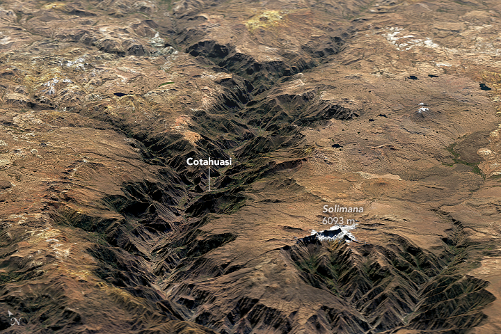
That remoteness is precisely its charm. Cotahuasi is for travelers after grand nature, authentic Andean villages and adventure, far from the crowds. The landscape combines the deep canyon carved by the Cotahuasi river with snow peaks above 6,000 meters -Coropuna and Solimana-, farming terraces, hot springs, forests of giant cactus and spectacular waterfalls. The whole area is part of a protected area, the Reserva Paisajística Subcuenca del Cotahuasi.

The usual way in is from Arequipa on a long bus or car journey (on the order of 9 to 11 hours) to the town of Cotahuasi, which serves as your base. From there you visit the sights, several of them quite spread out, so plan on at least 3 or 4 days. It's a destination with harder logistics than the Colca: bring cash, allow time and, ideally, lean on local operators or guides. Pack for both cold and heat (temperatures change a lot with altitude), sun protection and good footwear.

📖 History of Cañón de Cotahuasi

The Cotahuasi Canyon was carved over millions of years by the Cotahuasi river cutting its way through the Andes, in an area dominated by the Coropuna and Solimana snow peaks. The region has been inhabited since pre-Inca times -with a Wari presence- and later under the Incas, and it keeps terraces, roads and colonial villages. Today it is a Reserva Paisajística, protected for its natural and cultural value. More detail on the history page.

Read the full history ↓

🏛️ Cañón de Cotahuasi is in Arequipa

The 'White City' of sillar stone, at the foot of the Misti volcano: a colonial capital built of volcanic rock, cradle of rebellions and of Vargas Llosa, gateway to the Colca and to the Cotahuasi, one of the deepest canyons in the world.

Read the history of Arequipa →

🗺️ What to see

1
Sipia Waterfall
The canyon's most famous fall: the river narrows and plunges in an impressive drop (on the order of 150 m), with several successive falls.
The Sipia Waterfall is the great star of the Cotahuasi Canyon and, for many, the sight that justifies the long journey to this remote part of Arequipa. At this point the Cotahuasi river narrows sharply between rock walls and plunges some 150 meters in free fall, followed by several smaller drops partly hidden by the rugged ground. The roar of the water, the force of the river and the scale of the landscape make Sipia an overwhelming natural spectacle. It carries water all year, so it never disappoints. Getting there is part of the adventure. From the town of Cotahuasi you first drive about an hour to the Sipia bridge; from there a basic-level walk of roughly 1 kilometer runs alongside the river and takes you in under an hour to the viewpoint, where there are seats and a roof for taking in the fall. The path offers views of the river and the mountains the whole way. It's a walk most people can manage, though good footwear and care near the edge are advisable. It is the star of the Reserva Paisajística Subcuenca del Cotahuasi. Set aside at least half a day for the visit, counting the drive and the walk; with a guide or local transport everything is simpler, given how spread out the area is. The best time is the dry season (April/May to November), when the roads are in better shape. Bring water, a hat, sunscreen and something warm, because temperatures change with altitude. Don't forget cash, because there are no ATMs here and cards aren't accepted.
ℹ️ Height of the fall: Main drop of ~150 m · Access: ~1 h by vehicle + a ~1 km walk to the viewpoint · Time: Set aside at least half a day
2
Canyon viewpoints
Panoramic points over the depth of the canyon and the snow peaks, ideal for taking in the scale of the place.
The viewpoints are the best way to grasp what it means to stand in one of the deepest canyons in the world. The Cotahuasi Canyon drops more than 3,500 meters, a figure that on the ground translates into dizzying walls, a river far below and a horizon crowned by snow peaks above 6,000 meters. From various panoramic points along the route you take in that enormous scale, with the view opening over the abyss, the farming terraces on the slopes and the Coropuna and Solimana volcanoes behind. Along the road between Arequipa and Cotahuasi, and within the valley, there are several viewpoints worth stopping at. They are the ideal places for big landscape photos and for understanding why this destination wins over anyone after raw nature. Early morning and late afternoon light give the best colors on the canyon walls and the snowy summits. Many of these viewpoints are on the access road, so you make the most of them during transfers, especially if you're traveling by private vehicle or tour, which can stop at the key points (harder on a scheduled bus). There are no tickets and no opening hours: they are stops along the way. Bring warm clothes (at altitude and in the wind it's cold), sun protection and a camera or phone with battery. Because of the altitude, avoid sudden exertion and take it slowly at the higher viewpoints.
ℹ️ Depth of the canyon: More than 3,500 m (among the deepest in the world) · Best light: Sunrise and sunset
3
Luicho hot springs
Natural thermal pools, perfect for relaxing after the walks and the long drives.
The Luicho hot springs are one of the great prizes of the Cotahuasi Canyon: natural thermal pools in the middle of the valley, where sinking into hot water after long walks and endless drives feels like a genuine blessing. The waters, of geothermal origin, are prized for their relaxing effect on tired muscles, and the setting -mountains, open sky, the silence of the valley- makes the soak a memorable experience. It's a simple place, without big facilities, which is part of its rustic, authentic charm. The point is floating in warm water surrounded by the immensity of the Andean landscape, far from any crowd. It's the perfect counterpoint to the canyon's physical adventure: after visiting Sipia or walking the trails, there's nothing like a while in the springs to bring the body back. The springs are inside the Cotahuasi valley; the handiest way to get there is local transport or a tour, given how spread out the sights are. There's usually a cheap entry fee, on the order of S/ 5 to S/ 15 per person (indicative, check on site). Bring a swimsuit, towel, sandals and cash, because cards don't work here. The best time is the dry season, when the roads are in good shape; in any case, a thermal soak always goes down well on cool nights at altitude.
ℹ️ What it is: Natural thermal pools in the valley · Admission: Cheap, indicatively S/ 5-15 (check) · Bring: Swimsuit, towel and cash
4
Judiopampa cactus forest (Judío Pampa)
An extensive forest of columnar cactus several meters tall, an extraordinary landscape.
The Judiopampa cactus forest (also written Judío Pampa) is one of the most extraordinary landscapes in the Cotahuasi Canyon: a vast stand of giant columnar cactus rising several meters above the arid ground, creating a scene that looks like it belongs on another planet. These cactus, adapted to the canyon's dry climate, form a genuine 'forest' whose density and stature are a surprise, and which completely changes your idea of Andean vegetation. Walking among these green giants, with the canyon walls and the snow peaks behind, is a one-off visual experience, ideal for nature and photography lovers. The contrast between the arid ground, the green of the cactus and the immensity of the landscape makes Judiopampa a stop that stays with you. It is also a good example of the surprising biodiversity this landscape reserve holds. It's on the route through the valley, on the way to the Sipia Waterfall area, so it's usually combined in the same outing. To get there you'll want transport or a tour, given how spread out and remote the sights are. There isn't usually a formal admission: it's part of the landscape along the way. Bring strong sun protection (the canyon sun hits hard), water, a hat and good footwear. The best time, as for all of Cotahuasi, is the dry season, when the roads are passable.
ℹ️ What it is: A forest of giant columnar cactus · Can be combined: Usually seen on the route to the Sipia Waterfall
5
The Coropuna and Solimana snow peaks
The canyon's great guardians, above 6,000 m, dominating the horizon; Coropuna is a sacred volcano.
The Coropuna and Solimana snow peaks are the giants guarding the Cotahuasi Canyon and dominating its horizon. Both rise above 6,000 meters: Coropuna is the highest snow-capped volcano in southern Peru and one of the highest in the country, and it was considered a sacred mountain (an apu) by Andean cultures, who worshipped it. Solimana, its neighbor, completes the backdrop. Seeing their white summits rising over the canyon, especially under the clear skies of the dry season, is one of the most imposing images of the trip. For most visitors, these peaks are above all a spectacular scenic backdrop accompanying the whole route, visible from viewpoints, villages and valley trails. For better-prepared mountaineers and adventurers, Coropuna is also a high-mountain objective, with expeditions that require experience, acclimatization and specialist guides; it's not something to improvise. The peaks can be seen from various points in the canyon during transfers and walks, with no special access needed. To photograph them at their best you want the clear skies of the dry season (April/May to November) and the light of dawn or dusk. If you only want to look at them, you need nothing beyond warm clothes and a camera; if you're thinking of climbing Coropuna, that's another league: it takes serious planning, gear and specialist operators.
ℹ️ Altitude: Both rise above 6,000 m above sea level · Meaning: Coropuna was a sacred Andean volcano (apu)
6
Andean villages (Cotahuasi, Tomepampa, Alca, Puyca)
Villages of cobbled streets, colonial churches and traditional life, the base for exploring the area.
The Andean villages of the valley are the human soul of the Cotahuasi Canyon and one of the reasons it's worth coming all the way out here. Cotahuasi, the capital of La Unión province, is the main one and the usual base for trips, with its basic services, guesthouses and restaurants. Around it are other charming spots such as Tomepampa, with its white houses; Alca, with hot springs nearby; and Puyca, higher up and more traditional. They all share cobbled streets, colonial churches and an unhurried, authentic pace of life. Going through these villages is a look at real Andean life, far from mass tourism: people working the land, small markets, patron saint festivals, traditions that are still alive. The hospitality of the area is part of the appeal, and talking with locals, trying the home cooking and sleeping in a family guesthouse are experiences that enrich the trip as much as the landscapes. Cotahuasi is reached after the long journey from Arequipa (9 to 11 hours by bus, usually overnight); from there the other villages are connected by combis and colectivos with limited frequencies, so be flexible and ask about timetables locally. The choice of accommodation and food is simple but decent. Bring cash in soles (there are no ATMs), clothes for cold and heat, and patience for the logistics: in return, you take away the experience of genuine, very little visited Andean villages.
ℹ️ Main base: Cotahuasi (capital of La Unión province) · Other villages: Tomepampa, Alca, Puyca · Access: Bus from Arequipa (~9-11 h) + combis between villages
7
Terraces and pre-Hispanic sites
Farming terraces and archaeological remains (pre-Inca and Inca) dotted along the valley, such as Maukallacta.
The Cotahuasi Canyon is not only nature: it also has a rich pre-Hispanic heritage showing how pre-Inca and Inca cultures tamed this rugged territory. Along the valley slopes stretch millennia-old andenes (farming terraces), many still in use, which turned steep gradients into fertile land and are an impressive showing of Andean agricultural engineering. Seeing them step up the hillsides, green in the growing season, is to understand these people's deep relationship with the mountain. Alongside the terraces are archaeological remains such as Maukallacta, old settlements with walls, enclosures and traces of the pre-Inca and Inca occupation of the area, which saw a Wari presence and later an Inca one. They are less monumental than Peru's great icons, but loaded with history and very little visited, which gives them a special charm for the curious traveler. Walking them with a local guide adds a lot, because it puts context around what you see. These terraces and sites are spread around different points in the valley, so you visit them according to your route and the time you have, normally with local transport or a guide who knows the locations. Some are near the villages and others require a walk. The best time is the dry season, for the roads and to see the landscapes in their best light. As everywhere in Cotahuasi, bring water, sun protection, warm clothes and cash, and come in the frame of mind for a slow, exploratory trip.
ℹ️ What it is: Millennia-old terraces and pre-Inca/Inca remains (Maukallacta) · How to see them: With local transport or a guide; depending on the time you have
8
Valle de los Volcanes / nearby petroglyphs
Geological and archaeological sights in the surrounding area, depending on your route and the time you have.
The area around the Cotahuasi Canyon holds extra geological and archaeological sights for anyone with more days and an urge to explore. One of the most striking is the Valle de los Volcanes (in the Andagua area, part of the region and with related access), a plain dotted with small volcanic cones creating a lunar landscape unique in the Andes. Added to that, at various points around, are petroglyphs and rock carvings left by ancient cultures, testimony to the art and worldview of the area's first inhabitants. These are sights for the traveler with an explorer's spirit and time to spare, who has already seen the essentials (Sipia, hot springs, villages) and wants to go further. The region's volcanic geology, with its cones, its formations and its colors, fascinates nature lovers, while the petroglyphs draw those curious about deep history. It's worth being clear that some of these sites involve long drives and difficult roads. Given how remote and spread out these places are, a local guide or operator and, often, a suitable vehicle are essential; these aren't visits to improvise on your own. Plan them ahead, add days to your itinerary and ask carefully about logistics in Cotahuasi or from Arequipa. The dry season is the only advisable time for this access. Bring everything you need for areas with no services: water, food, cash, warm clothes and sun protection. This is the frontier of adventure in a region that is already among the most rugged in Peru.
ℹ️ Who it's for: The exploring traveler with extra days · Requires: A local guide/operator and good planning
Advertisements
What nobody tells you

💵 Prices

Tickets

TypePrice
Entry to the Reserva Paisajística Subcuenca del CotahuasiFree (open access; some specific sights charge a separate community fee; verified July 2026)
Sipia Waterfall (community fee)S/ 5-10 per person in cash (source: Arequipa agencies / MarvelousPeru, verified July 2026; a maintenance fee charged by the local community)
Luicho hot springsS/ 5-15 per person in cash (verified July 2026)
Local guide for a full dayS/ 250-450 a day (verified July 2026); strongly recommended given how spread out and remote the area is
🔄 updated monthlyOfficial / reference values · double-check when buying

Activities and tours

ActivityPriceDurationOperator
Cotahuasi Canyon tour from Arequipa (3 days / 2 nights, group)US$ 180-320 per person (includes transport, guide and basic accommodation; 2025)3 days (includes long drives)Arequipa agencies (Ander Ra Travel, Rumbo a Perú, Expeditions Machu Picchu and similar)
Cotahuasi Canyon tour, 4 days (fuller, includes the Valle de los Volcanes)US$ 280-420 per person (verified July 2026)4 daysArequipa agencies
Visit to the Sipia Waterfall (transfer + walk + guide)S/ 80-150 per person on a shared tour; S/ 500-900 a day for a private 4x4 with driver (verified July 2026)Half day to full dayLocal transport and guide
Expedition rafting/kayaking on the Cotahuasi river (extreme adventure)US$ 1,500-2,500 per person, a multi-day expedition with full logistics (verified July 2026); only with specialist operatorsSeveral days (expedition)International whitewater operators (advanced)
🔄 updated monthlyOfficial / reference values · double-check when buying
Advertisements

🚌 How to get there and distances

Getting around

ModePriceDurationNotes
Combis and colectivos between valley villagesS/ 3-15 in cash depending on the leg (verified July 2026)VariableLimited frequencies; ask about timetables locally and stay flexible. You ALWAYS pay in cash (there's no card and no payment app) and it helps to carry small change. Important: in this remote area there are no real-time transport apps like Moovit and no reliable coverage; go by what people tell you in the village and check timetables the day before.
Taxi or hired transport / 4x4 with driverS/ 500-900 a day in cash (verified July 2026)VariableThe handiest way to reach spread-out sights such as Sipia or the hot springs. You book directly in Cotahuasi or through your agency in Arequipa; there's no Uber and no taxi apps. Agree the price and the itinerary in advance.
Walking (trekking)Free (a guide is recommended, S/ 250-450 a day; verified July 2026)Hours to daysMany of the canyon's sights are reached on foot; some paths are demanding.
🔄 updated monthlyOfficial / reference values · double-check when buying

How to get there

RouteAirlines / operatorsAvg. priceDuration
Lima → Arequipa (plane)LATAM, Sky Airline, JetSMARTUS$ 40-130 per leg depending on how far ahead you book and the season (verified July 2026)~1 h 30 flight
Arequipa → Cotahuasi (intercity bus)Transportes Reyna, Cromotex and similar (they leave from the Arequipa bus terminal)S/ 40-90 per leg depending on the company and the service, plus ~S/ 1,50 boarding ticket (source: rome2rio / redBus, verified July 2026)~8 to 9 h (usually overnight, leaving between 17:30 and 19:00 h)
Arequipa → Cotahuasi (private vehicle / 4x4)Operators and private transfersS/ 110-200 return shared; from S/ 500 a day private (verified July 2026)~8 to 9 h with stops at viewpoints
Lima → Arequipa (bus)Cruz del Sur, Civa, Oltursa and othersUS$ 25-70 depending on the class of service (verified July 2026)~15 to 16 h
🔄 updated monthlyOfficial / reference values · double-check when buying

🏨 Where to stay

No exact prices: a scale from $ (budget) to $$$$$ (luxury), with 2-3 options per category.

CategoryPriceRecommended options
The best available (simple)$$$$$S/ 60-120 a night; basic but decent guesthouses and small hotels in the town of Cotahuasi, some with hot water and limited wifi
Rural guesthouses$$$$$S/ 35-60 a night; guest houses and family-run places in Cotahuasi, Tomepampa or Alca
Budget / backpacker$$$$$S/ 20-35 a night; very simple places to stay, limited choice given how remote the destination is
Camping / adventure$$$$$S/ 0-20 a night (for the ground) or included in trekking tours; the option of camping on guided expeditions through the canyon

🍴 Where to eat

TypePriceOptions / signature dish
Arequipa and local Andean cooking$$$$$S/ 20-40 per dish; small restaurants in Cotahuasi with regional dishes, trout and home cooking
Eateries and set menus$$$$$S/ 10-18 for the set menu of the day; simple eateries in the town and in villages around the valley
Local produce$$$$$S/ 3-15; fruit, cheeses and local produce in markets; worth stocking up for long trips out
Advertisements

📖 History of Cañón de Cotahuasi

Origins, formation and what the sources say.

One of the deepest canyons in the world

The Cotahuasi Canyon opens in the far northwest of the Arequipa region, in the province of La Unión, carved by the Cotahuasi river over millions of years. At more than 3,500 meters deep, it ranks among the deepest canyons on the planet, deeper even than the famous Colca. Measured from the riverbed to the summits flanking it, the total drop is greater still, dominated by the Coropuna and Solimana snow peaks, which reach or exceed 6,000 meters.

Its formation is a chapter of Andean geology. The uplift of the range, the area's volcanic activity and the relentless erosion of the river gradually opened this extremely deep cut in the earth. The result is a landscape of enormous scale and variety: within a few kilometers you go from frozen summits to warm valley floors beside the river, crossing very different ecological levels, with farming terraces, forests of giant cactus and spectacular waterfalls.

To protect that natural and cultural heritage, the whole area is part of the Reserva Paisajística Subcuenca del Cotahuasi, a protected area that safeguards not only the canyon itself but also the biodiversity, the snow peaks, the wetlands and the traditional ways of life of the communities living there.

es.wikipedia.org · Cañón de Cotahuasivivearequipa.com · Canon de cotahuasiterandes.com · Cotahuasi canyon

A valley inhabited since pre-Inca times

The Cotahuasi valley is not only nature: it has been the setting for human life for thousands of years. The area was inhabited in pre-Inca times, with a presence of the Wari culture -the great Andean state that spread across much of the Peruvian highlands around the first millennium AD- and was later absorbed into the Inca empire. From those times, farming terraces, stretches of pre-Hispanic roads and archaeological remains survive across the valley.

Turning the landscape into agricultural terraces was key to farming such broken ground. As in other Andean regions, communities turned the slopes into terraces held up by stone walls, making use of the canyon's different ecological levels to produce a remarkable variety of crops. That farming heritage is still alive in the valley's villages.

With the arrival of the Spanish, the valley was drawn into the colonial order, and many of its villages -Cotahuasi, Tomepampa, Alca, Puyca- keep churches and street plans of colonial origin on older foundations. Walking their cobbled streets, seeing their churches and talking with their people is a glimpse of a historical continuity running from pre-Inca cultures to the present, in one of the most remote and authentic corners of the Andes.

es.wikipedia.org · Distrito de Cotahuasimachupicchuterra.com · Canon cotahuasies.wikipedia.org · Cañón de Cotahuasi

Nature, conservation and adventure

Cotahuasi's great treasure is its nature. The Sipia Waterfall, its most famous fall, forms where the river narrows sharply and plunges tens of meters in an imposing drop: one of the most remembered images of the canyon. Alongside it are the Luicho hot springs, ideal after a day's walking, and the surprising Judiopampa cactus forest, where columnar cactus reach several meters in a landscape that seems almost otherworldly.

Watching over the whole thing rise the Coropuna and Solimana snow peaks. Coropuna, as well as being one of the highest mountains in Peru, was an important apu, a sacred mountain for Andean cultures, tied to pilgrimages and rituals in pre-Hispanic times. Its snowy bulk, along with Solimana's, gives the canyon a high-mountain frame that few places offer.

Today that richness makes Cotahuasi a nature and adventure destination: trekking between villages and terraces, visits to waterfalls and hot springs, and even whitewater descents for the most experienced, since the Cotahuasi river is known among expedition kayakers and rafters. Its status as a landscape reserve seeks to balance that tourism with conservation of the ecosystem and respect for the communities, in one of the most impressive and least crowded corners of Peru.

marvelousperu.com · Canon del cotahuasi expedicionmarvelousperu.com · Canon cotahuasi guia completavivearequipa.com · Canon de cotahuasi

From isolated region to Reserva Paisajística

For much of the 20th century, the Cotahuasi valley remained one of the most isolated areas of Peru's southern highlands, with difficult dirt roads and little connection to Arequipa, the region's main city. That same remoteness, which held back the economic development of La Unión province, ended up being the reason its natural and archaeological heritage was preserved in a remarkably pristine state, without the pressure of mass tourism or urban sprawl.

Official recognition of that value came in 1988, when the Peruvian state declared the area the Reserva Paisajística Subcuenca del Cotahuasi, one of the protected area categories of the National System of Protected Natural Areas (Sernanp), designed specifically to reconcile conservation with the traditional human and productive activity of its inhabitants, unlike a national park with more restricted access.

Since then, the gradual improvement of the road from Arequipa and the growing fame of the canyon —driven by its standing as one of the deepest in the world— have drawn a growing, though still modest, number of adventure and nature travelers. Today Cotahuasi is promoted as a destination to complement the Colca, for anyone after a less crowded experience, built on community tourism and on local operators who want tourism development to benefit the valley's villages directly.

es.wikipedia.org · Cañón de Cotahuasigob.pe · Sernanpmarvelousperu.com · Canon cotahuasi guia completa

The Cotahuasi river: a challenge for explorers

If the canyon is the work, the Cotahuasi river is the sculptor. This watercourse, which rises in the heights near Coropuna and runs down to join the Ocoña river downstream before reaching the Pacific, is what carved over millions of years the extremely deep gorge that amazes travelers today. Its boxed-in course, with whitewater rapids and stretches that are almost impossible to reach, made it at once a natural barrier and a coveted objective for explorers from all over the world.

In the 1990s, Cotahuasi entered the history of river exploration. International kayaking and rafting expeditions set out to run the river through the canyon for the first time, on multi-day journeys through one of the most remote and committing whitewater stretches on the planet, with no escape routes and no help nearby. Those first descents —documented by the specialist press and by National Geographic— put Cotahuasi on the world map of expedition rafting, alongside the great canyon rivers of the world, and confirmed it as one of the most demanding world-class descents there is.

That explorer's legacy is still alive. Today only a handful of specialist international operators run whitewater expeditions on the Cotahuasi, reserved for very experienced rafters and kayakers, on trips planned down to the last detail during the right water season. For the ordinary traveler, the river is not something you navigate but something you look at from the viewpoints and from the foot of the Sipia Waterfall; but knowing that some of the boldest expeditions in the history of rafting went down that thread of water below adds an extra layer of epic to the immensity of the landscape.

marvelousperu.com · Canon del cotahuasi expediciones.wikipedia.org · Río Cotahuasies.wikipedia.org · Cañón de Cotahuasi

📚 Bibliography

  • Wikipedia (ES) — «Cañón de Cotahuasi»: https://es.wikipedia.org/wiki/Ca%C3%B1%C3%B3n_de_Cotahuasi
  • Wikipedia (ES) — «Distrito de Cotahuasi»: https://es.wikipedia.org/wiki/Distrito_de_Cotahuasi
  • Vive Arequipa — Cañón de Cotahuasi: https://www.vivearequipa.com/en/canon-de-cotahuasi/
  • Terandes — Cotahuasi Canyon: https://terandes.com/en/blog/arequipa/cotahuasi-canyon/
  • Machu Picchu Terra — Cañón de Cotahuasi: https://www.machupicchuterra.com/arequipa/the-union/canon-cotahuasi/
  • Marvelous Peru — Cañón del Cotahuasi: expedición, historia, rutas: https://www.marvelousperu.com/blog/canon-del-cotahuasi-expedicion/
  • Marvelous Peru — Cañón de Cotahuasi: guía completa: https://www.marvelousperu.com/blog/canon-cotahuasi-guia-completa/
  • Sernanp — Servicio Nacional de Áreas Naturales Protegidas: https://www.gob.pe/sernanp
  • Wikipedia (ES) — «Río Cotahuasi»: https://es.wikipedia.org/wiki/R%C3%ADo_Cotahuasi

❓ Frequently asked questions

Is Cotahuasi deeper than the Colca?+
Yes. The Cotahuasi Canyon drops more than 3,500 meters, which makes it somewhat deeper than the Colca and puts it among the deepest canyons in the world. The difference is that Cotahuasi is far more remote and less visited, so it offers a more solitary, rugged experience.
How many days do I need?+
Given the distance from Arequipa (some 9 to 11 hours of travel) and how spread out the sights are, plan on at least 3 or 4 days. A couple of days is barely enough to get there and back. If you want to enjoy the waterfalls, the hot springs, the villages and a walk at a calm pace, allow more time.
How do I get there from Arequipa?+
The usual way is by intercity bus from Arequipa to the town of Cotahuasi, a long journey (on the order of 9 to 11 hours) usually done overnight. You can also go by private vehicle or 4x4, a bit faster and with stops at viewpoints. There's no commercial airport in the area, so access is overland.
What is the Sipia Waterfall?+
It's the most famous waterfall in the canyon: at one point the Cotahuasi river narrows sharply and plunges in an impressive drop, on the order of 150 meters, with several successive falls. Getting there usually means transport plus a walk, so allow half a day or more and, if you can, go with a guide.
Do I need a guide or a local operator?+
It's strongly recommended. The area is remote, the sights are spread out, public transport runs infrequently and some paths are demanding. An Arequipa operator or a local guide sorts out the logistics, takes you to the key spots and adds safety, especially if you want to trek or reach the Sipia Waterfall.
Are there hot springs?+
Yes, the Luicho hot springs are one of the valley's draws: natural thermal pools, ideal for relaxing after the walks and the long drives. There's usually a cheap entry fee. Bring a swimsuit, a towel and some cash.
Is it a destination for every traveler?+
It's more for anyone after grand nature, adventure and authenticity, who doesn't mind harder logistics and basic services. If you want something comfortable and easy to reach, the Colca is simpler. Cotahuasi rewards the patient traveler with enormous landscapes, authentic villages and very few people.
Sources consulted (7)
Still planning?
Explore more destinations in Peru
See all destinations →
Advertisements
Image credits
Photos from Wikimedia Commons, each under its own licence (CC BY, CC BY-SA or public domain). Open each file to see its author and licence.
Cotahuasi Canyon oblique