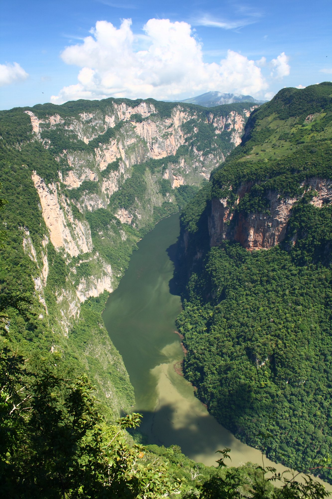
Sumidero Canyon is one of Mexico's great natural wonders and the symbol of the state of Chiapas: so much so that it appears on its coat of arms. It's an imposing gorge carved over millions of years by the Grijalva River, with sheer walls that in places rise more than 1,000 meters. Sailing through it, between those giant walls that seem to close in over the water, is an overwhelming experience and the one activity you shouldn't miss in the region.
The classic trip is by speedboat from the Chiapa de Corzo dock: for about two hours the boat runs deep into the canyon, showing off its most famous corners, such as the 'Árbol de Navidad' (Christmas Tree) waterfall —a wall covered in moss and mineral formations, shaped like a tree, with water trickling down it—, the 'Cueva de Colores', the 'Cueva del Silencio' and the statue of the Virgin of Guadalupe carved into the rock. In its waters and along its banks you'll see river crocodiles sunning themselves, herons, spider monkeys, pelicans and, with luck, other birds and mammals.
The other way to enjoy it is from above: a road out of Tuxtla links a series of lookouts (Los Chiapa, La Ceiba, La Coyota, El Roblar, El Tepehuaje) perched on the edge of the precipice, with dizzying views down to the river below. This guide covers how to organize the visit, the official boat and national park rates, the best time to go and the tips to make the most of this unique natural setting, which is part of a protected national park.
Sumidero Canyon was formed over millions of years by the erosion of the Grijalva River on the limestone rock of the sierra, opening a gorge with sheer walls more than 1,000 meters high. It also carries a historical weight: according to tradition, in the 16th century a group of Chiapanec Indigenous people chose to throw themselves into the canyon rather than submit to the Spanish conquistadors. In 1980 it was declared a National Park. The full story is on our history page.
Read the full history ↓The southeasternmost province, of jungle, mountains and living Maya cultures: land of Palenque and Pakal the Great, of colonial San Cristóbal, of the Sumidero Canyon and of the 1994 Zapatista uprising.
Read the history of Chiapas →They depart from Tuxtla Gutierrez, 10 km away. If you book from this link we earn a commission and you pay no more.
No exact prices: a scale from $ (budget) to $$$$$ (luxury), with 2-3 options per category.
Origins, formation and what the sources say.
Tradition has it that around 1528 a group of Chiapanec warriors, cornered by the Spanish conquistadors, made a terrible decision: rather than surrender and live under Spanish rule, they threw themselves and their families into the void from the top of these walls, more than a thousand meters high. True or legendary, that leap turned Sumidero Canyon into a symbol of resistance so powerful that it appears today on the coat of arms of the state of Chiapas. But the gorge that staged that drama is itself far older than any human story: it is the work of water and time, carved over millions of years.
Sumidero Canyon was formed over millions of years by the erosive action of the Grijalva River, which slowly cut through the limestone of the Chiapas sierra until it opened an extremely deep gorge. The result is a canyon with almost vertical walls that in places rise more than 1,000 meters, one of the most spectacular gorges in Mexico.
The dominant rock is limestone, formed from sediments laid down when the region was covered by the sea, tens of millions of years ago. As the sierra was uplifted and the river cut down into it, the water exploited the fractures and the solubility of the limestone to excavate the canyon, in a geological process comparable to that of other great gorges around the world. That same limestone explains the caves and mineral formations, such as the 'Árbol de Navidad' waterfall, where water loaded with minerals trickling down the rock built up deposits on the wall.
The Grijalva River, which gives the canyon its life, is one of the highest-flowing in Mexico and rises in Guatemala. Downstream of the Sumidero its flow is regulated by the Chicoasén dam (Manuel Moreno Torres), one of the most important in the country, whose reservoir forms part of the boat route and keeps the water level that makes navigation possible.
The canyon region and the Grijalva valley were inhabited from very early times by a range of peoples. Among the most prominent were the Chiapanecs, a warrior people who controlled much of the area when the Spanish arrived and who gave their name to the region and, in time, to the state of Chiapas. Their main settlement was near present-day Chiapa de Corzo, beside the river.
The Chiapanecs were known for their fierceness and their resistance, and they were in conflict with neighboring peoples. The Grijalva River and the canyon were part of their territory and of their symbolic world. This Indigenous presence is essential to understanding the later history of the canyon, tied to the Spanish conquest.
The area also preserves archaeological remains: in the Chiapa de Corzo area important and very old traces of pre-Hispanic occupation have been found, showing the long continuity of human settlement in the valley, long before the colonial towns were founded.
Right next to the dock the boats leave from today, Chiapa de Corzo hides one of the oldest and most important archaeological sites in southern Mesoamerica, with continuous human occupation going back more than two thousand five hundred years, long before the Maya heyday. This settlement, at a strategic point in the Grijalva valley, was a center of the Preclassic (or Formative) cultures that flourished in the region, in contact with the Olmec world and with the Zoque and Maya peoples.
Its most celebrated find is Stela 2 of Chiapa de Corzo, a fragment of a limestone slab that preserves a calendar inscription in the Mesoamerican 'Long Count' system. According to specialists' reconstruction, the carved date corresponds to 8 December of the year 36 BC: it is the oldest known Long Count date in all of Mesoamerica, earlier even than the famous Stela C of Tres Zapotes, in Veracruz. That the oldest calendar record on the continent comes from this corner of Chiapas says a great deal about the sophistication of the peoples who lived in the Grijalva valley.
The piece is kept today in the Museo Regional de Chiapas, in Tuxtla Gutiérrez. Its existence is a reminder that the canyon and its surroundings are not only a natural spectacle but also a land with a very deep human memory, where time was measured and cities were raised centuries before the Spanish arrived.
The most famous historical episode tied to Sumidero Canyon took place during the Spanish conquest of Chiapas, in the 16th century. According to tradition, around 1528, during the clashes between the conquistadors —led by captains such as Diego de Mazariegos— and the Indigenous peoples of the region, a group of Chiapanecs, rather than surrender and submit to Spanish rule, chose to throw themselves into the void from the top of the canyon, together with their families.
This story of the 'leap into the Sumidero', passed down for centuries, became a symbol of the resistance and the dignity of the Indigenous peoples of Chiapas in the face of the conquest. The image of warriors preferring death to submission was engraved in the collective memory and in Chiapas identity, and the boatmen usually tell it during the ride.
Historians debate how accurate and how large the episode was: some treat it as a historical fact, others as a later construction with more symbolic than documentary value, and they dispute the figures and the circumstances. Whatever the precision of the details, the legend of the leap into the canyon is inseparable from the cultural meaning of the Sumidero and from the history of the conquest of Chiapas.
For its exceptional natural value, Sumidero Canyon was declared a National Park on 8 December 1980, under the government of José López Portillo. The declaration sought to protect not only the canyon itself but the whole ecosystem: the limestone walls, the dry forest, the wildlife —with its river crocodiles, spider monkeys, herons and many birds— and the Grijalva River basin along that stretch.
The park is run by the National Commission of Natural Protected Areas (CONANP). Its challenges include conserving biodiversity, managing tourism —which is heavy, above all on the boat trips— and environmental problems such as the build-up of rubbish that the Grijalva River carries down from upstream, especially in the rainy season, which the authorities try to control with clean-up operations.
Sumidero Canyon is today one of the great symbols of Chiapas: its silhouette appears on the state's coat of arms, in tribute to the legend of Chiapanec resistance and to the grandeur of its landscape. It is one of the most visited natural destinations in southern Mexico and the main attraction of the Tuxtla and Chiapa de Corzo region, where the geological spectacle, the biological richness and the historical memory come together in a single setting.