Viajá con Gus
HomeUnited StatesJoshua Tree National Park
Joshua Tree National Park
🇺🇸 United States · West Coast and California

Joshua Tree National Park

Jump to what you need
📌State
California (south), between the Mojave and Colorado deserts
📌Best time to go
October to April (pleasant weather); avoid the summer heat
📌Suggested days
1 to 2 days
📌Currency
US dollar (USD)
💱 USD exchange rate
Loading rate…
🌤️ Weather in Joshua Tree National Park
Loading weather…

Joshua Tree National Park is one of the most singular and best-loved desert landscapes in California: a world of Joshua trees with their twisted arms, giant piles of rounded granite, star-filled night skies and a silence that invites contemplation. It sits where two great deserts meet, the high Mojave and the low Colorado, which gives it flora and scenery that change depending on which part of the park you are in.

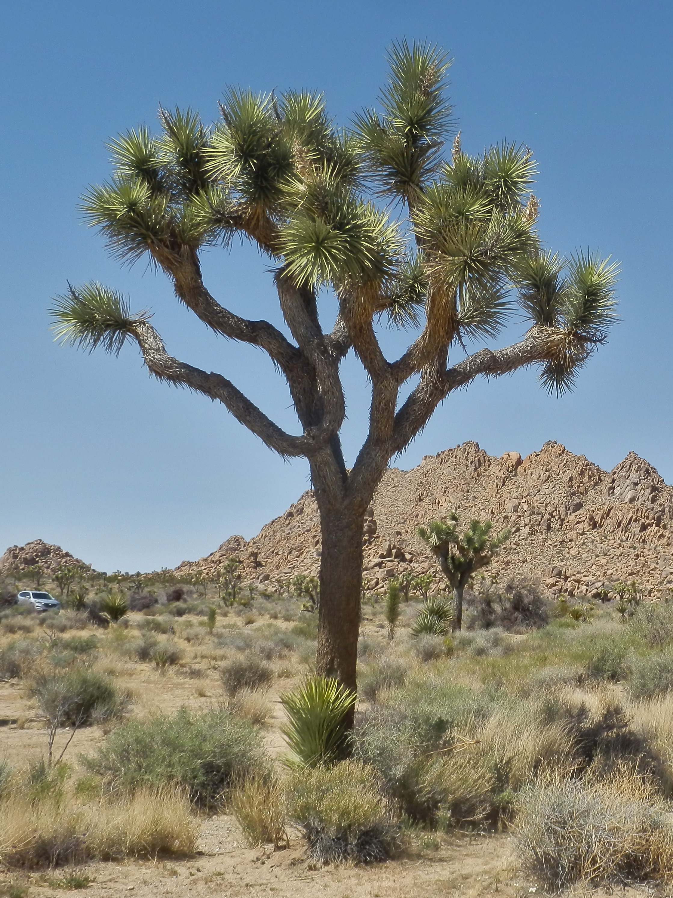
The Joshua tree (Yucca brevifolia), which gives the park its name, is not a tree but a giant yucca of ghostly appearance, a symbol of the Mojave Desert. Legend has it that Mormon settlers named it because its outstretched branches reminded them of the prophet Joshua pointing the way. Alongside these trees, the spectacular stacks of rounded rock turn the park into a paradise for climbers, photographers and nature lovers, and into a magnet for Southern California's artistic and musical culture.

This guide walks you through the essentials of Joshua Tree with a practical eye: which trails, lookouts and rock formations to see, where the best spots for climbing and stargazing are, how to plan the visit while avoiding the summer heat, the desert precautions (water, fuel, no cell signal at all) and where to sleep and eat in the gateway towns. It is an ideal destination in itself or combined with Palm Springs and Southern California.

📖 History of Joshua Tree National Park

The region was the territory of Native peoples such as the Serrano, Cahuilla, Chemehuevi and Mojave, who made use of its oases and resources. In the 19th century came ranchers and miners who left traces such as mines and dams for livestock. The Joshua trees are said to have been named by Mormon settlers, who saw in their branches the biblical prophet pointing the way. The activist Minerva Hoyt pushed for protection of the desert against the plundering of cactus and plants, and in 1936 Joshua Tree National Monument was created, raised to National Park status in 1994. The full story is on our history page.

Read the full history ↓

🏛️ Joshua Tree National Park is in California

The golden state of the Pacific: land of dozens of Native peoples and of the Franciscan missions, forged by the gold rush of 1849, today the largest economy in the United States and the cradle of Hollywood, Silicon Valley and legendary parks such as Yosemite and Sequoia.

Read the history of California →

🗺️ What to see

1
Hidden Valley
A loop trail among rock formations enclosing a hidden valley, ideal for a first walk.
Hidden Valley is one of the most popular and accessible spots in the park, and an excellent introduction to its landscape. A short, easy loop trail (about 1.6 km) runs through a valley literally hidden among great walls and piles of rock, which tradition says once served as a hideout for cattle rustlers. It is a good place to see Joshua trees up close, the park's signature rocks and, almost always, climbers in action. The route suits nearly everyone, with a few stretches of stone steps. It is ideal at sunrise or sunset, when the light turns the rocks golden. There are parking and picnic areas nearby. Getting there: by car along Park Boulevard, in the center-west of the park. Best time: all year; sunrise or sunset for the best light. Tips: carry water even for the short walk; the parking lot fills up fast in high season.
ℹ️ Center-west of the park. Loop trail ~1.6 km, easy. Access included in the park entrance fee (US$ 30 per vehicle, verified July 2026).
2
Keys View
A panoramic lookout over the Coachella Valley, the San Andreas Fault and the desert.
Keys View is the park's great panoramic lookout, set high in the Little San Bernardino Mountains at more than 1,500 meters. From here, on clear days, you take in a huge view of the Coachella Valley, with the city of Palm Springs down below, the Salton Sea in the distance, imposing Mount San Jacinto opposite and, cutting across the landscape, the line of the San Andreas Fault. You reach it by car along a paved road up to the parking lot, from where a very short walk leads to the viewpoint. It is especially recommended at sunset. The quality of the view depends a great deal on how clear the air is, which is sometimes affected by haze from the valley. Getting there: by car along Keys View Road, about 20 minutes from Hidden Valley. Best time: sunset, with clear air. Tips: it is considerably colder and windier than the rest of the park because of the altitude; bring a jacket.
ℹ️ End of Keys View Road. Car access + a short 5-minute walk. Included in the park entrance fee. Best at sunset and with clear air.
3
Cholla Cactus Garden
A dense natural garden of 'teddy bear' cholla cactus, in the transition between the two deserts.
The Cholla Cactus Garden is a natural, extremely dense concentration of 'teddy bear' cholla cactus, so called for their seemingly soft, furry look, which in fact hides very fine and painful spines. A short, flat trail winds among thousands of these cactus, which glow as if lit from within when backlit at sunrise or sunset. It lies in the lower part of the park, in the transition zone toward the Colorado Desert, on the road between the north (Joshua tree country) and the south entrance. It is one of the most photogenic corners of the park. Important: do not touch the cactus under any circumstances; the spines dig in easily and are very hard to remove. Getting there: on Pinto Basin Road, between the northern zone and the south entrance (Cottonwood). Best time: sunrise or sunset, with low, raking light. Tips: carry tweezers or a comb (to pull out spines in case of an accident); stay on the marked trail.
ℹ️ Pinto Basin Road (desert transition zone). Short, flat trail, about 20 min. Included in the park entrance fee. Do not touch the cactus!
4
Skull Rock and Jumbo Rocks
Rock formations sculpted by erosion, including one shaped like a skull.
The Jumbo Rocks area is a maze of enormous rounded granite boulders, sculpted by millennia of erosion, that invites you to scramble, explore and photograph. There you find Skull Rock, a rock that erosion has carved with two hollows giving it an unmistakable skull-like look, right beside the main road and very easy to visit. A short trail (the Skull Rock Nature Trail, about 2.4 km) runs through the area among the formations, and very close by is one of the park's most popular campgrounds, Jumbo Rocks Campground, ringed by these rocks. It is an excellent place to understand why Joshua Tree is famous for its granite landscape. Getting there: on Park Boulevard, in the center of the park. Best time: all year; late in the day for scrambling on the rocks without so much heat. Tips: free scrambling on the rocks is popular but calls for care, especially in the heat.
ℹ️ Beside Park Boulevard, center of the park. Skull Rock right by the roadside; short trail ~2.4 km. Included in the park entrance fee.
5
Rock climbing and bouldering
One of the most famous climbing destinations in the United States, with thousands of granite routes.
Joshua Tree is, along with Yosemite, one of the great temples of rock climbing in the United States, with more than 8,000 recorded routes spread across its formations of monzogranite, rough-textured and very grippy. Areas such as Hidden Valley, Real Hidden Valley, Echo Rock and the surroundings of Jumbo Rocks are world classics of traditional (trad) climbing and bouldering, with routes for every level, from beginners to experts. Anyone who has never climbed can start with local schools, which offer half-day or full-day classes with all the gear included. The best-known schools (Joshua Tree Guides, Joshua Tree Rock Climbing School, Vertical Adventures, Mojave Guides) have AMGA-certified guides. Getting there: the climbing areas are spread along Park Boulevard, above all in Hidden Valley and around it. Best time: October to April, avoiding the extreme summer heat. Tips: book classes ahead in high season; carry plenty of water even when climbing in shaded areas.
ℹ️ Climbing technique class (4 h): US$ 175-275 per person depending on group size. Anchors and rappel class (8 h): US$ 250-350. Two-day climbing course: US$ 515-675 (source: Joshua Tree Guides, verified July 2026).
6
Stargazing (dark sky)
One of the best night skies in Southern California for seeing stars and the Milky Way.
Joshua Tree is a celebrated destination for amateur astronomy and night photography: despite being relatively close to the Southern California megalopolis, it keeps skies dark enough to make out thousands of stars and, on moonless nights, the Milky Way crossing the firmament. The park is recognized as an International Dark Sky Park. On a clear, moonless night, all it takes is getting away from the lights, letting your eyes adapt to the dark and looking up. The silhouettes of the Joshua trees and rocks cut against the starry sky are one of the most sought-after images of the park. It is worth dressing warmly (desert nights are cold) and carrying a red-light flashlight. Getting there: any part of the park away from the entrances and the glow of the towns. Best time: moonless nights, any season (more comfortable in spring/fall because of the temperature). Tips: download offline maps (there is no signal); tell someone where you are if you go far from the car.
ℹ️ Anywhere in the park (best away from the entrances). Best on moonless nights. Included in the park entrance fee; dress warmly for the night cold.
Advertisements
What nobody tells you

💵 Prices

Tickets

TypePrice
Park entrance (per vehicle, valid 7 days)US$ 30 per vehicle (source: NPS Joshua Tree, verified July 2026)
Individual entrance (on foot/by bike, 7 days)US$ 15 per person; under 16s free (source: NPS Joshua Tree, verified July 2026)
Motorcycle entrance (7 days)US$ 25 (source: NPS Joshua Tree, verified July 2026)
Joshua Tree annual passUS$ 55 (source: NPS Joshua Tree, verified July 2026)
America the Beautiful annual passUS$ 80 (valid for one year in every US national park; source: NPS, verified July 2026)
Guided climbing class (half day, 4 h)US$ 175-275 per person depending on group size (source: Joshua Tree Guides, verified July 2026)
🔄 updated monthlyOfficial / reference values · double-check when buying

Activities and tours

ActivityPriceDurationOperator
Hiking (Hidden Valley, Barker Dam, Ryan Mountain, Lost Palms Oasis)Included in the entrance fee1-4 hOn your own (National Park Service)
Rock climbing (bouldering and routes, with a guide)US$ 175-275 half day; US$ 250-350 full day; 2-day course US$ 515-675 (source: Joshua Tree Guides, verified July 2026)Half day to 2 daysJoshua Tree Guides, Vertical Adventures, Mojave Guides
Stargazing and astrophotographyFree (park entrance separate)At nightOn your own
Scenic drive and lookoutsIncluded in the entrance fee (plus fuel)Half day to full dayOn your own
🔄 updated monthlyOfficial / reference values · double-check when buying
Advertisements

🚌 How to get there and distances

Getting around

ModePriceDurationNotes
Own or rental car (ESSENTIAL)Rental from US$ 45-70 a day (source: rental aggregators, verified July 2026)VariableIt is the only real way to tour the park. IMPORTANT: Joshua Tree does NOT have its own free shuttle like Zion or Bryce. The pilot 'Roadrunner Shuttle' service run by Basin Transit in 2018-2019 was discontinued for low demand and never came back. Inside the park there is no public transport and no services: fill up on fuel and water before going in (source: NPS Joshua Tree / Basin Transit, verified July 2026)
Basin Transit (public bus in the gateway towns)Neighborhood routes (3A/3B/7A/7B/21) US$ 1,25; intercity routes (1A/1B) US$ 2,50; day pass US$ 3,75; Route 12 to Palm Springs US$ 7 from Yucca Valley/Joshua Tree (source: basin-transit.com/fares, verified July 2026)VariableBasin Transit (formerly Morongo Basin Transit Authority) connects Yucca Valley, the town of Joshua Tree and Twentynine Palms, and runs Route 12 to Palm Springs airport (PSP). It does NOT go into the park, only as far as the towns at the gates. It is useful for moving between towns without a car, not for sightseeing inside the park
How you pay and track the bus (Basin Transit)Cash (exact fare, the driver gives no change) or a mobile pass through an app-You pay in cash with the exact fare or with the mobile pass in the Token Transit app (available since April 2026); physical passes are sold too. To see schedules and the bus location in real time use the Transit or Moovit app, which cover the Basin Transit routes (source: basin-transit.com / Token Transit, verified July 2026)
On foot (trails)FreeVariableThe attractions pair up with short walks; carry plenty of water and avoid the midday heat in summer
Bicycle (on the roads)Rental about US$ 25-40/day in the towns of Joshua Tree/Yucca Valley (source: local businesses, verified July 2026)VariableAllowed only on paved roads, not on trails. Demanding because of the heat and the long distances without shade
🔄 updated monthlyOfficial / reference values · double-check when buying

How to get there

RouteAirlines / operatorsAvg. priceDuration
Palm Springs → Joshua Tree (south or west entrance)Rental car; toursRental from US$ 45/day; organized tours from US$ 90 per personAbout 45 min - 1 h to the northern entrances
Los Angeles → Joshua TreeRental carRental from US$ 45/day + fuelAbout 2.5-3 h
Las Vegas → Joshua TreeRental carRental from US$ 45/day + fuelAbout 3.5-4 h
Palm Springs Airport (PSP) → Joshua TreeRental carRental from US$ 45/dayAbout 1 h
🔄 updated monthlyOfficial / reference values · double-check when buying

🏨 Where to stay

No exact prices: a scale from $ (budget) to $$$$$ (luxury), with 2-3 options per category.

CategoryPriceRecommended options
Design houses / desert Airbnbs$$$$$US$ 180-400 a night; design rentals and modern houses in the towns of Joshua Tree, Yucca Valley and Twentynine Palms (very popular, book ahead)
Mid-range hotels and motels$$$$$US$ 110-200 a night; options in Twentynine Palms and Yucca Valley (chains and motels); the historic 29 Palms Inn from US$ 150
Budget / basic motels$$$$$US$ 70-110 a night; budget motels in Twentynine Palms and Yucca Valley
Camping inside the park$$$$$US$ 20-25 per site/night (Jumbo Rocks, Hidden Valley, Indian Cove, Black Rock, Cottonwood; source: NPS/recreation.gov, verified July 2026); book through recreation.gov in high season

🍴 Where to eat

TypePriceOptions / signature dish
Bohemian food / cafés$$$$$US$ 12-25 per person; cafés, food trucks and artsy restaurants in the town of Joshua Tree and Yucca Valley (e.g. Natural Sisters Cafe, Crossroads Cafe)
Saloon / Americana with live music$$$$$US$ 20-40 per person; Pappy & Harriet's (Pioneertown, legendary for its live music and barbecue; book ahead)
Casual and Mexican$$$$$US$ 12-25 per person; diners, taquerías and Mexican restaurants in Twentynine Palms and Yucca Valley
Supplies$$$$$Supermarkets in the towns (standard US prices); it is worth taking food and plenty of water into the park (there are no services inside)
Advertisements

📖 History of Joshua Tree National Park

Origins, formation and what the sources say.

Native peoples of the desert

The territory covered today by Joshua Tree National Park was inhabited and traveled for thousands of years by various Native peoples adapted to life in the desert. At different times and in different areas the Serrano, the Cahuilla, the Chemehuevi and the Mojave, among others, were present. These peoples knew the desert's resources inside out: they used the oases and springs, gathered seeds and fruit from plants such as mesquite and piñon, hunted the local wildlife and made basketry and stone tools.

The palm oases, fed by water surfacing along geological faults, were key points in their geography: places of water, shade and resources in the middle of the aridity. Some of these oases, such as the Oasis of Mara (in the Twentynine Palms area), saw long human occupation. The desert peoples also left petroglyphs and rock paintings at various points in the region.

The arrival of explorers, ranchers and miners in the 19th century profoundly altered their world, with pressure on water and resources. Even so, the Indigenous presence left a lasting mark on the region, and those peoples' knowledge of how to live in such an extreme environment remains part of the park's deep history.

The name, the ranchers and the miners

The tree that gives the park its name, the Joshua tree (Yucca brevifolia), is a giant yucca endemic to the Mojave Desert, unmistakable with its twisted branches ending in spiny tufts. The most widespread explanation of its name credits the christening to Mormon settlers who, crossing the desert in the 19th century, are said to have seen in the outstretched branches of these trees the figure of the biblical prophet Joshua with his arms raised, guiding them toward the promised land. It is a much-cited popular etymology, though hard to document with certainty.

Through the 19th century and the early 20th, the region drew ranchers who brought cattle to graze and looked for water, and prospectors after gold and other minerals. Traces of that era survive: abandoned mines such as the Lost Horse Mine or the Desert Queen Mine, and dams built to water livestock, such as Barker Dam, today a popular hiking destination. Figures such as the rancher and miner Bill Keys left their mark, with ranches and structures the park preserves.

These uses —ranching, mining, the search for water— left marks on the landscape, but they also put pressure on a fragile ecosystem. The uncontrolled removal of desert plants in particular began to alarm those who valued that unique landscape, sowing the seed of the movement that would lead to its protection.

Origin of the name 'Joshua tree'
The most popular version credits the name to Mormon settlers who saw in the tree's branches the prophet Joshua pointing the way. It is a traditional explanation, widely repeated, though its precise historical documentation is uncertain.
Source: Wikipedia (EN) — «Yucca brevifolia»: https://en.wikipedia.org/wiki/Yucca_brevifolia

Minerva Hoyt and the creation of the park

In the early 20th century, the spread of the automobile and the closeness of Los Angeles brought visitors to the desert who, in many cases, tore up cactus and plants to take away or sell as ornamentals, devastating whole areas. Against that plundering a key figure emerged: Minerva Hamilton Hoyt, an activist from Pasadena society who fell in love with the desert and devoted enormous effort to its protection. She organized desert plant exhibitions, founded conservation societies and lobbied the authorities tirelessly to protect that landscape.

Thanks in large part to her campaign, in 1936 President Franklin D. Roosevelt proclaimed Joshua Tree National Monument, placing a vast stretch of desert under federal protection. The monument preserved the Joshua trees, the rock formations and the oases, halting plant removal and degradation. Minerva Hoyt is remembered as the 'mother' of the park, and her name is forever tied to this desert.

Decades later, in 1994, the California Desert Protection Act raised the monument to the status of Joshua Tree National Park and expanded its boundaries. Today the park is one of the most visited in the United States, famous for its surreal landscape, its climbing scene, its starry skies and its artistic atmosphere, which has inspired musicians and creators. The story of its protection, driven by the determination of a single person, is a reminder of the power of activism on nature's behalf.

An artistic magnet and the threat of climate change

From the second half of the 20th century, the desert around Joshua Tree became a magnet for musicians, artists and seekers of spiritual experience, drawn by its lunar landscape, its silence and its starry skies. The country rock musician Gram Parsons made the Joshua Tree Inn a regular refuge in the 1970s, and after his death there in 1973 in circumstances that fed a legend of their own, the place was forever tied to rock mythology. Later, U2's album 'The Joshua Tree' (1987), with its iconic cover shot in the nearby desert, completed the projection of the park's name into global popular culture. Today, neighboring towns such as Joshua Tree and Pioneertown keep that bohemian scene alive, with galleries, live music and a creative tourism that coexists with the desert atmosphere.

While the park celebrates its cultural status, it faces an existential threat of another kind: climate change. Scientific studies warn that, if the current pace of warming and drought continues, the park could lose up to 80% of its Joshua trees by 2070, and that a temperature rise of around 5°C would leave less than 1% of the species' current habitat viable by the end of the century. The problem is not only drought and the greater fire risk (worsened by invasive grasses that increase the available fuel), but that in the hottest parts of the park the trees already barely manage to reproduce, which stops them from shifting toward cooler areas as the climate changes.

Faced with this outlook, the National Park Service, biologists and conservation organizations are working on monitoring, restoration and adaptation projects, including the experimental planting of seedlings at higher elevations that could serve as future climate refuges. The park's own name thus faces a paradox: it was created to protect a tree that, without decisive global climate action, could disappear from much of the territory that bears its name.

📚 Bibliography

  • National Park Service — «Joshua Tree National Park»: https://www.nps.gov/jotr/index.htm
  • Wikipedia (EN) — «Joshua Tree National Park»: https://en.wikipedia.org/wiki/Joshua_Tree_National_Park
  • Wikipedia (ES) — «Parque nacional Joshua Tree»: https://es.wikipedia.org/wiki/Parque_nacional_Joshua_Tree
  • Wikipedia (EN) — «Yucca brevifolia»: https://en.wikipedia.org/wiki/Yucca_brevifolia
  • Wikipedia (EN) — «Minerva Hoyt»: https://en.wikipedia.org/wiki/Minerva_Hoyt
  • Wikipedia (EN) — «The Joshua Tree (album)»: https://en.wikipedia.org/wiki/The_Joshua_Tree
  • National Geographic — «Joshua trees may disappear with climate change»: https://www.nationalgeographic.com/environment/article/joshua-trees-moths-threatened-climate-change-scientists-seek-solutions
  • U.S. Fish & Wildlife Service — «Adapting to Climate and Fire»: https://www.fws.gov/project/adapting-climate-and-fire-joshua-tree-national-park

❓ Frequently asked questions

What is a Joshua tree?+
The Joshua tree (Yucca brevifolia) is not really a tree but a giant yucca characteristic of the Mojave Desert, with a fibrous trunk and twisted branches ending in tufts of spiky leaves. Its name is attributed to Mormon settlers, who are said to have seen in its outstretched branches the biblical prophet Joshua pointing the way. It is the symbol of the park.
When is the best time to visit?+
October to April, when the temperatures are pleasant (mild days, cold nights). Summer (June to September) is very hot, with a real risk from the heat; in those months you have to limit activity to the early hours of the day, carry a great deal of water and avoid walking at midday. Spring can bring wildflowers.
How many days do I need?+
You can see the essentials in a day (Hidden Valley, Keys View, Skull Rock, Cholla Cactus Garden), especially as a day trip from Palm Springs. With 2 days and a night you also get the sunset and the stargazing, which is one of the park's great draws.
Are there services inside the park?+
No. Inside the park there is no fuel, no food and no drinking water at most points, and cell coverage is practically nil. You have to go in with a full tank, plenty of water (several liters per person) and food. The services are in the gateway towns (Joshua Tree, Twentynine Palms, Yucca Valley).
Can you climb in Joshua Tree?+
Yes, it is one of the most famous rock climbing and bouldering destinations in the United States, with more than 8,000 recorded routes. There are routes for every level, and local schools and guides offering courses and outings from about US$ 175 for a half day. Simple scrambling on the rocks is also very popular in areas such as Jumbo Rocks.
What desert precautions should I take?+
Carry plenty of water, sun protection and a hat; avoid the midday heat in summer; do not touch the cholla cactus (their spines dig in easily); watch out for snakes and scorpions; dress warmly at night (it cools down a lot); and do not rely on your phone to find your way, because there is no signal. It is worth telling someone your itinerary.
Is there a shuttle or public transport for touring Joshua Tree without a car?+
Not inside the park. Unlike Zion, Bryce or Grand Canyon, Joshua Tree has no free shuttle running between its attractions: the 2018-2019 pilot 'Roadrunner' service was discontinued and never came back. To see the park you need your own or a rental car. Basin Transit (the local bus, formerly Morongo Basin Transit Authority) does connect the gateway towns —Yucca Valley, Joshua Tree and Twentynine Palms— and runs Route 12 to Palm Springs airport (US$ 7 for the leg from Yucca Valley/Joshua Tree), but it does not go into the park.
How do you pay for the bus in the Joshua Tree area and which app should I use?+
The local bus is Basin Transit. You pay in cash with the exact fare (the driver gives no change) or with a mobile pass in the Token Transit app (available since April 2026); there are physical passes too. Fares run from US$ 1,25 (neighborhood routes) to US$ 2,50 (intercity routes), with a day pass at US$ 3,75. To see schedules and the bus location in real time, use the Transit or Moovit app.
Sources consulted (10)
Still planning?
Explore more destinations in United States
See all destinations →
Advertisements
Image credits
Photos from Wikimedia Commons, each under its own licence (CC BY, CC BY-SA or public domain). Open each file to see its author and licence.
Joshua Tree Nationalpark P4130402