Viajá con Gus
HomeUnited StatesAcadia
Acadia
🇺🇸 United States · New England

Acadia

Jump to what you need
📌State
Acadia National Park is in the state of Maine (New England), on the Atlantic coast of the northeastern United States. Most of the park spreads across Mount Desert Island, the largest island in Maine, and it also takes in the Schoodic Peninsula (on the mainland) and part of Isle au Haut. It is the only national park in New England and one of the most visited in the country. It combines granite mountains that drop into the sea, forests, lakes, a rocky shore pounded by the Atlantic and the famous 'carriage roads', car-free carriage lanes donated by the Rockefeller family.
📌Service town
Bar Harbor, on Mount Desert Island, is the park's main service town: it concentrates the hotels, restaurants, shops, the area visitor center and most tourist services. Other towns on the island, such as Northeast Harbor and Southwest Harbor, offer quieter lodging. The closest air access is Hancock County-Bar Harbor Airport (BHB), with regional flights, and Bangor International Airport (BGR), a little over an hour away by car. The region's great gateway is the airport in Portland (Maine) or Boston, from where you drive in (about 3 hours from Portland, 5 from Boston) or take a bus.
📌Best time
Summer (late June to August) is the high season: warm, pleasant weather, every service open and maximum activity, but also plenty of people, traffic and the need to book ahead (including the timed reservation for driving up Cadillac Mountain). Autumn (especially late September and October) is spectacular for the foliage (the forests turn red, orange and gold), with cool weather and fewer crowds, one of the best times of year. Spring (May-June) is quiet but still chilly. In winter the park is largely closed to traffic, ideal for cross-country skiing and solitude, with very reduced services.
📌Suggested days
Two days cover the essentials: driving the Park Loop Road, watching sunrise or sunset on Cadillac Mountain, Thunder Hole, Sand Beach and Jordan Pond. With three to five days you enjoy the park in depth, adding mountain trails, bike rides along the carriage roads, a boat trip to see lighthouses or whales, the quieter Schoodic Peninsula and time for Bar Harbor. Acadia is best enjoyed by alternating scenic driving, hiking, biking and coast, with time for those legendary sunrises.
💱 USD exchange rate
Loading rate…
🌤️ Weather in Acadia
Loading weather…

Acadia National Park is one of the most beautiful corners of the east coast of the United States: a place where pink granite mountains plunge straight into the Atlantic Ocean, conifer forests fringe crystal-clear lakes and the rocky shore bursts into foam with every wave. Set on the rugged coast of Maine, above all on Mount Desert Island, it is the only national park in New England and one of the best loved and most visited in the country, famous for its sunrises, its scenic drives and its unique blend of mountain and sea.

Acadia has a particular history: much of its landscape was preserved and shaped thanks to the philanthropy of wealthy families who summered in the area in the early 20th century. John D. Rockefeller Jr. financed and designed the famous 'carriage roads', a network of gravel lanes for horse-drawn carriages —no cars— with elegant stone bridges, which today are a paradise for walking, biking or riding. The Park Loop Road, by contrast, takes drivers to the most spectacular spots: the summit of Cadillac Mountain, the first ground in the United States to catch the sun at certain times of year, the roaring Thunder Hole and the serene Jordan Pond.

This guide walks you through Acadia with a practical, warm eye: how to get there and get around (including the free Island Explorer shuttle), which viewpoints, beaches and trails not to miss, how to enjoy the carriage roads by bike, where to watch the sunrise and where to eat a good Maine lobster. Acadia calls for comfortable shoes, the will to get up before dawn for the sunrises and time to let that meeting of forest, granite and ocean surprise you.

📖 History of Acadia

Long before the Europeans arrived, the Mount Desert Island region was the territory of the Wabanaki people, especially the Penobscot and other nations of the confederacy, who came seasonally to fish, gather shellfish and hunt, and who called the island by their own names. In 1604, the French explorer Samuel de Champlain sailed through the area and christened the island 'Isle des Monts Déserts' (Island of the Barren Mountains), for its bare granite summits, a name that became 'Mount Desert'. The region was part of the disputed French Acadia, from which the park takes its name. Through the 19th century, the island's beauty drew painters of the Hudson River School and then wealthy summer visitors (the 'rusticators'), who built great summer mansions ('cottages') in Bar Harbor. Worried about protecting the landscape from logging and development, philanthropists such as George B. Dorr (considered the 'father of Acadia'), Charles W. Eliot and John D. Rockefeller Jr. donated land and money. Sieur de Monts National Monument was created in 1916, in 1919 it became Lafayette National Park (the first national park east of the Mississippi) and in 1929 it took the name Acadia National Park. Rockefeller also financed the carriage roads. A huge fire in 1947 swept much of the island, transforming the forest. The full story is on our history page.

Read the full history ↓

🏛️ Acadia is in Maine

The state of the pine and the lobster: Wabanaki land in the far northeast of the country, of rocky shores dotted with lighthouses, of immense forests and of Acadia National Park, the first east of the Mississippi.

Read the history of Maine →

🗺️ What to see

1
Cadillac Mountain (the summit and the sunrise)
The highest mountain on the country's Atlantic coast, famous for being one of the first places to catch the sun and for its 360-degree views.
Cadillac Mountain is the high point of Acadia and of the whole Atlantic coast of the United States, at 466 meters. Its bare, pink granite summit offers a 360-degree panorama over Mount Desert Island, Frenchman Bay, the Porcupine Islands scattered across the sea and the park's forests and lakes. It is Acadia's most celebrated lookout and one of the most impressive in the Northeast. What made this mountain famous is its relationship with the sunrise: for several months of the year (roughly from autumn to early spring), its summit is one of the first places in the continental United States to catch the rays of the rising sun. That is why watching the sunrise from Cadillac Mountain, with the sky catching fire over the ocean, has become a ritual for visitors, who get up in the dark and drive up so as not to miss it. Sunset is magnificent too and is usually less crowded at the edge of night. You can reach the summit by car along a scenic road (Cadillac Summit Road) or on foot by several mountain trails. Because demand is enormous, the National Park Service brought in a timed vehicle reservation system for driving up during the high season: you have to book an entry time in advance. Getting there: by car along the Cadillac Summit Road (with a reservation in season) or on foot by trails such as the Cadillac North Ridge. Best time: sunrise in the months when it is the first point to catch the sun; any clear day for the views. Tips: if you go for sunrise, bring warm layers (it is cold and windy up top), a flashlight and book the vehicle time slot well ahead on recreation.gov. Check sunrise times and the forecast.
ℹ️ Distance: Mount Desert Island; Cadillac Summit Road off the Park Loop Road · Best time: Sunrise (the country's first sunlight in certain months); clear days · Admission: Park pass (US$ 35 per vehicle, 7 days) + vehicle reservation for the Summit Road US$ 6 on recreation.gov (20 May–25 Oct). Non-residents: add a surcharge of US$ 100/person (16+) unless you hold an America the Beautiful Pass (verified July 2026) · Duration: 1 to 2 hours (more for the sunrise)
2
Park Loop Road (the scenic drive)
The roughly 43 km scenic loop that links the park's most spectacular spots along the coast and the mountain.
The Park Loop Road is the backbone of a visit to Acadia: a scenic loop of about 43 kilometers that runs through the park's most spectacular landscapes on Mount Desert Island, connecting the rocky coast, the forests and the climb up Cadillac Mountain. It is the simplest way to get a first complete view of the park and to reach most of its unmissable attractions. Along the way (much of it one-way) come the classic stops: the Sieur de Monts area, the Ocean Drive shoreline with Sand Beach, Thunder Hole and the cliffs of Otter Cliff, the serene Jordan Pond with 'The Bubbles' mountains behind it, and the turn-off up to the summit of Cadillac Mountain. Numerous viewpoints and parking areas let you stop to take in the landscape, take photos or start a hike. You can drive the road at your own pace, stopping wherever you like, or take the free Island Explorer shuttle, which in season covers much of the route and lets you leave the car behind. Cycling some stretches is popular too. In high season, parking at the busiest spots (Sand Beach, Thunder Hole, Jordan Pond) fills up early, so it pays to start at dawn or use the shuttle. Getting there: access from Bar Harbor and other points on the island; the main direction of travel is single-lane for much of the way. Best time: early in the morning to avoid crowds; autumn for the foliage. Tips: give it at least half a day with stops at the viewpoints; use the Island Explorer to avoid parking trouble; bring water, a light jacket and comfortable shoes so you can combine driving with short walks.
ℹ️ Distance: A loop of about 43 km on Mount Desert Island; access from Bar Harbor · Best time: Early morning; autumn for the foliage · Admission: Included in the park pass (US$ 35 per vehicle, 7 days, verified July 2026; check when you visit at nps.gov/acad) · Duration: Half a day or more (with stops)
3
Thunder Hole and the Ocean Path shoreline
A sea inlet where the surf explodes with a roar, on the park's most spectacular stretch of rocky coast.
Thunder Hole is one of the most distinctive spots on the Acadia coast: a small inlet and cleft in the granite where, with the right tide and swell, the waves rush in, compress the air and burst with a deep boom —hence the name 'thunder hole'— throwing up sprays of foam. It is a fascinating natural spectacle, above all when the sea is rough and the tide is about halfway in and rising. Thunder Hole sits on the Ocean Drive stretch of the Park Loop Road, one of the park's most iconic landscapes: kilometers of pink granite shore battered by the Atlantic, with cliffs, coves and open-sea views. Next to Thunder Hole there is a platform and steps for looking down safely (you have to respect the barriers and the signs, because big waves can be dangerous). You can walk this stretch along the Ocean Path, a relatively easy coastal trail linking Sand Beach with Otter Point, passing Thunder Hole and the cliffs of Otter Cliff (one of the most famous rock-climbing spots in the eastern United States). It is one of the loveliest and most accessible walks in Acadia, with the ocean always in view. Getting there: by car or on the Island Explorer shuttle along the Park Loop Road; there is parking (which fills up early). Best time: with the tide coming in and a rough sea to see the 'thunder' at full force; check the tide tables. Tips: always respect the barriers (unexpected waves are dangerous), wear suitable footwear for the rocks and combine Thunder Hole with a walk along the Ocean Path to Sand Beach or Otter Cliff.
ℹ️ Distance: Ocean Drive, on the Park Loop Road; between Sand Beach and Otter Point · Best time: With the tide coming in and a rough sea; check the tide tables · Admission: Included in the park pass (US$ 35 per vehicle, 7 days, verified July 2026; check when you visit) · Duration: 30 min to 2 hours (with the Ocean Path)
4
Jordan Pond and The Bubbles
A crystal-clear lake framed by two rounded hills, with a trail around it and the popover tradition at the Jordan Pond House.
Jordan Pond is one of the most serene and best-loved landscapes in Acadia: a glacial lake of exceptionally clear, cold water, framed at its far end by two rounded twin hills known as 'The Bubbles', which reflect on the surface on calm days. The lake's transparency is remarkable, and its setting of forest and mountain makes it a perfect place for quiet contemplation and photography. A flat, pleasant trail of about 5 kilometers goes right around the lake (the Jordan Pond Path), much of it on wooden boardwalks, offering constant views of the water and The Bubbles. It is one of the park's most popular and accessible walks, ideal for families. For the more active, there are trails up to the top of the Bubbles (with magnificent views and the famous 'Bubble Rock', an enormous boulder left by a glacier on the edge of a drop) and up other nearby mountains. Beside the lake stands the Jordan Pond House, a historic restaurant famous for a tradition more than a century old: afternoon tea with 'popovers' (light, hollow rolls served with jam) on its lawn, looking out over the lake and The Bubbles. It is a classic Acadia experience, very busy in season. Getting there: by car or on the Island Explorer shuttle; there is parking next to the Jordan Pond House. Best time: calm days for the reflections; autumn for the foliage. Tips: the trail around the lake is easy and highly recommended; if you want the popovers there may be a wait (booking is sometimes worthwhile); bring insect repellent in summer and comfortable shoes.
ℹ️ Distance: Center of Mount Desert Island, on the Park Loop Road · Best time: Calm days for the reflections; autumn for the foliage · Admission: Included in the park pass; the restaurant and the popovers are paid separately (tea with popovers approx. US$ 12–15, verified July 2026; check when you visit) · Duration: 2 to 3 hours (with the lake trail)
5
Sand Beach
One of the park's few sand beaches, in a cove sheltered between granite cliffs, with cold, bracing water.
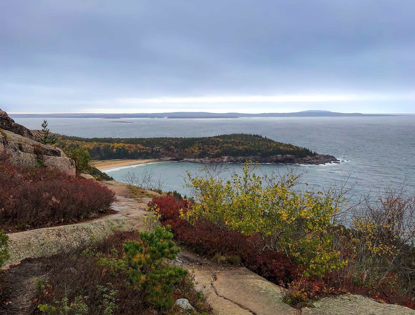
Sand Beach is one of the few sand beaches in Acadia, a rarity on a coast dominated by granite and rock. It lies in a cove sheltered between mountains and cliffs, on the Ocean Drive stretch of the Park Loop Road, and its sand has a peculiar make-up: as well as grains of quartz and feldspar, it contains a large proportion of crushed shells and fragments of marine organisms, which give it a distinctive look and feel. The setting is spectacular: the beach is framed by the wooded slopes of the Beehive on one side and the rocky shore on the other, with the open ocean in front. It is a lovely place to walk on the sand, sunbathe and take in the landscape. The water, though, is very cold even in high summer (the temperature of the North Atlantic rarely rises above a few degrees), so swimming is for the brave and tends to be short and bracing. Several trails start from Sand Beach: the Ocean Path toward Thunder Hole, and the demanding, vertiginous climb up the Beehive (with iron rungs and ladders set in the rock, only for those with no fear of heights). The combination of beach, mountain and ocean makes this one of the best areas for spending several hours. Getting there: by car or on the Island Explorer shuttle along the Park Loop Road; the parking fills up very early in season. Best time: summer to enjoy the beach; any clear day for the landscape. Tips: arrive early because of the parking or use the shuttle; the water is freezing (be ready); combine the beach with the Ocean Path or, if you are up for it, the climb up the Beehive (not for anyone who suffers from vertigo).
ℹ️ Distance: Ocean Drive, on the Park Loop Road · Best time: Summer for the beach; clear days for the landscape · Admission: Included in the park pass (US$ 35 per vehicle, 7 days, verified July 2026; check when you visit) · Duration: Half a day (with nearby trails)
6
Carriage Roads (Rockefeller's carriage lanes)
Some 72 km of car-free gravel roads, with elegant stone bridges, donated by the Rockefeller family, ideal for biking, walking and riding.
The Carriage Roads are one of Acadia's great treasures and one of its most singular features: a network of some 72 kilometers of packed gravel roads, free of motor vehicles, winding through the interior of the park among forests, lakes, streams and mountainsides. They were financed and designed between 1913 and 1940 by John D. Rockefeller Jr., a great lover of the area, who wanted roads for touring the landscape by horse-drawn carriage, away from cars. What sets these roads apart is their careful landscape design and, above all, their seventeen stone bridges, each one different, built with masterful craftsmanship, crossing streams, gorges and waterfalls and now architectural landmarks of the park. The roads were made to blend into the landscape, with gentle curves and natural viewpoints, and they are a pleasure to travel. Today the carriage roads are a paradise for cycling (a mountain or hybrid bike, given the gravel surface), walking, running, horseback riding or, in winter, cross-country skiing. They let you get into parts of the park cars cannot reach, with the calm of having no motor traffic. There are bike rental shops in Bar Harbor and maps showing the routes and their difficulty. Getting there: there are several access points, for example near Jordan Pond, Eagle Lake or Bar Harbor. Best time: spring, summer and above all autumn with the foliage are ideal. Tips: rent a bike in Bar Harbor if you don't bring your own, carry water and a map of the roads, and plan the route to match your fitness (some stretches are flat, others climb). Don't miss at least one of the stone bridges.
ℹ️ Distance: Some 72 km through the interior of Mount Desert Island; several access points · Best time: Spring, summer and autumn (foliage); winter for cross-country skiing · Admission: Use included in the park pass; bike rental separate (standard bike approx. US$ 30–40/day; e-bike US$ 95–125/day, verified July 2026; check when you visit) · Duration: From 1 hour to a full day
7
Bar Harbor
The tourist town beside the park, with its shore path, lobster restaurants, shops and boat trips.
Bar Harbor is the gateway and main service center for Acadia: a picturesque Maine coastal town on the shore of Frenchman Bay, on Mount Desert Island, combining its past as an elegant summer resort with its present role as a base for visiting the park. Its compact, walkable center is full of restaurants, ice cream parlors, shops, galleries and inns, and gets very lively in season. One of its attractions is the Shore Path, a coastal walk along the water with views of the bay and the Porcupine Islands, lined with some of the old summer mansions. Another curiosity is the 'Bar Island Sandbar': at low tide a bar of sand and gravel is exposed, letting you walk across to nearby Bar Island; you have to keep an eye on the tide tables so as not to be cut off when the water rises. Numerous boat trips also leave from Bar Harbor's harbor: whale watching, lighthouse cruises, outings on a classic sailing vessel and lobster fishing trips. Bar Harbor is also the place to sleep, stock up and eat, especially the Maine classics: lobster in all its forms. Since big cruise ships call in season, the town can be very crowded on certain days. Getting there: by car, or from Bangor airport; on the island, the Island Explorer shuttle links the town with the park. Best time: summer for the atmosphere in full swing; autumn for the foliage and slightly fewer people. Tips: use the Island Explorer to get to the park without parking headaches; book boat trips and lodging well ahead in season; check the tides if you plan to cross to Bar Island.
ℹ️ Distance: Mount Desert Island, next to the park; Frenchman Bay · Best time: Summer for the atmosphere; autumn for the foliage · Admission: Walking around town is free; boat trips are booked separately (whale watching from approx. US$ 88 adults, verified July 2026; check when you visit) · Duration: Half a day (more with boat trips)
8
Schoodic Peninsula
The mainland part of the park, quieter and wilder, with a spectacular rocky coast and far fewer crowds.
The Schoodic Peninsula is the only portion of Acadia National Park on the mainland (the rest is on islands), and it offers a quieter, wilder and more solitary experience than busy Mount Desert Island. It lies to the east, across Frenchman Bay, and takes a somewhat longer drive to reach, which keeps the crowds away and makes it a refuge for anyone after peace and quiet. Its main draw is the spectacular pink granite coast, hammered by the open Atlantic, especially impressive at Schoodic Point, where the waves explode against the rock with tremendous force on days of heavy swell. A scenic road (the Schoodic Loop Road, one-way for much of its length) runs around the peninsula with viewpoints over the open sea, the islands and, in the distance, the silhouette of Cadillac Mountain. There are also trails and bike paths that take you into its forests and shoreline. Schoodic is a good complement for anyone who already knows the main part of the park and wants to see another face of Acadia, or who would rather avoid the crowds of Mount Desert Island. The nearby town of Winter Harbor serves as a base. In season, a passenger ferry links Bar Harbor with the Schoodic area, which lets you combine the two. Getting there: by car along the Schoodic Loop Road (a longer drive from Bar Harbor, around the bay) or, in season, by ferry from Bar Harbor plus the local shuttle. Best time: any time of year for the quiet; autumn for the foliage and days of heavy swell to see the surf at Schoodic Point. Tips: bring everything you need (there are fewer services), respect the barriers by the sea and enjoy the solitude and the rugged landscape.
ℹ️ Distance: On the mainland, east of Frenchman Bay; Schoodic Loop Road · Best time: All year for the quiet; autumn for the foliage; heavy swell for the surf · Admission: Included in the park pass (US$ 35 per vehicle, 7 days, verified July 2026; check when you visit) · Duration: Half a day
Advertisements
What nobody tells you

💵 Prices

Tickets

TypePrice
Acadia National Park entrance pass (per vehicle, valid 7 days)US$ 35 per vehicle; US$ 30 per motorcycle; US$ 20 per person on foot or by bike (source: official NPS, verified July 2026)
IMPORTANT — Surcharge for NON-residents of the U.S. (from 2026)US$ 100 per person aged 16 or over, IN ADDITION to the vehicle pass. Acadia is one of the 11 parks with this surcharge. It is waived if you enter with an America the Beautiful Pass or with the new annual America the Beautiful Non-Resident Pass (US$ 250) (source: official NPS, verified July 2026)
Vehicle reservation for the Cadillac Summit Road (20 May–25 October)US$ 6 per vehicle + a small booking fee on recreation.gov (separate from the park pass, verified July 2026)
Island Explorer shuttle (in season, late June to mid-October)Free (funded by fees and donations)
America the Beautiful Pass (annual, all national parks)US$ 80 a year (U.S. residents); for non-residents, since 2026 there is the America the Beautiful Non-Resident Pass at US$ 250 a year, which covers the vehicle and waives the surcharge (verified July 2026)
Bike rental (carriage roads)Standard bike approx. US$ 30–40 per day; e-bike US$ 95–125 per day (Bar Harbor, verified July 2026)
Whale watching trip from Bar HarborFrom approx. US$ 88 adults (Bar Harbor Whale Watch Co., verified July 2026)
Tea and popovers at the Jordan Pond HouseApprox. US$ 12–15 for tea with popovers (verified July 2026; check when you visit)
Trails, viewpoints and shorelineIncluded in the park pass
🔄 updated monthlyOfficial / reference values · double-check when buying

Activities and tours

ActivityPriceDurationOperator
Driving the Park Loop Road with stops at the viewpointsIncluded in the park pass (US$ 35 per vehicle, verified July 2026)Half a day or moreYour own car or the Island Explorer shuttle
Sunrise on Cadillac MountainPark pass + vehicle reservation US$ 6 + US$ 4 booking fee (verified July 2026)2 to 3 h (before dawn)Your own car (with a reservation) or a guided tour
Biking the Carriage RoadsRental approx. US$ 30–40/day for a standard bike; US$ 95–125/day for an e-bike (verified July 2026)Half a dayBar Harbor bike rental shops
Hiking the trails (Ocean Path, Jordan Pond, Beehive, Cadillac)Included in the park pass (US$ 35 per vehicle, verified July 2026)1 h to a full dayPark trails (self-guided)
Whale watching from Bar HarborFrom approx. US$ 88 adults; less for children (verified July 2026)3 to 4 hBar Harbor Whale Watch Co. and others
Boat trip to lighthouses or on a classic sailing vesselApprox. US$ 45–75 per person depending on the trip (verified July 2026)2 to 3 hBar Harbor boat operators
Sea kayaking along the coast and the baysGuided half-day trip approx. US$ 60–90 per person (verified July 2026)Half a dayLocal outfitters (Coastal Kayaking Tours)
Trip to the Schoodic PeninsulaPark pass included; ferry from Bar Harbor approx. US$ 25–35 round trip (verified July 2026)Half a dayYour own car or ferry + shuttle
🔄 updated monthlyOfficial / reference values · double-check when buying
Advertisements

🚌 How to get there and distances

Getting around

ModePriceDurationNotes
Island Explorer (free seasonal shuttle)Free (in season)VariesA network of free buses linking Bar Harbor, the island's towns, campgrounds and the park's main points (Park Loop Road, Jordan Pond, Sand Beach). Ideal for avoiding the parking problem; it usually runs from late June to October
Own or rental carRental approx. US$ 60–110/day in season; fuel extra (verified July 2026)VariesConvenient for driving the Park Loop Road, Cadillac (with a reservation in season) and Schoodic, and for reaching the park. In high season, parking at the popular spots fills up very early
Bicycle (carriage roads and routes)Rental approx. US$ 30–40/day for a standard bike; US$ 95–125/day for an e-bike (verified July 2026)VariesExcellent for the car-free carriage roads and for getting around the island; there are rental shops in Bar Harbor. Bikes can be carried on some Island Explorer shuttles
On foot (park trails)Included in the passVariesAcadia has an extensive trail network for every level; many attractions are linked on foot, especially along the coastal Ocean Path
Taxi and appsApprox. US$ 3–4 flag drop + US$ 2–3/mile; short trips in Bar Harbor US$ 10–20 (verified July 2026)VariesAvailable in Bar Harbor, useful for one-off trips; supply is limited compared with a big city
Passenger ferry to Schoodic (in season)Approx. US$ 25–35 round trip (verified July 2026)VariesIn season, a ferry links Bar Harbor with the Schoodic Peninsula area, where it connects with a local shuttle
🔄 updated monthlyOfficial / reference values · double-check when buying

How to get there

RouteAirlines / operatorsAvg. priceDuration
Bangor Airport (BGR) → Bar Harbor / Acadia (by car)Rental car; Route 1 and Route 3Fuel approx. US$ 8–12 each way; car rental from approx. US$ 60/day (verified July 2026)Approx. 1 to 1.5 h
Portland Airport (Maine) → Acadia (by car)Rental car; I-95 and Route 1/3Fuel approx. US$ 25–35 each way; rental extra (verified July 2026)Approx. 3 h
Boston → Acadia (by car)Rental car; I-95 northFuel and tolls approx. US$ 45–60 each way (verified July 2026)Approx. 5 h
Regional flights to Hancock County-Bar Harbor Airport (BHB)Cape Air and other regional airlinesApprox. US$ 80–200 each way depending on the season (verified July 2026)Depends on the origin (more frequent in summer)
Boston / Bangor → Bar Harbor (long-distance bus)Concord Coach Lines and connectionsApprox. US$ 35–60 each way from Boston (verified July 2026)Depends on the origin (several hours)
🔄 updated monthlyOfficial / reference values · double-check when buying

🏨 Where to stay

No exact prices: a scale from $ (budget) to $$$$$ (luxury), with 2-3 options per category.

CategoryPriceRecommended options
High-end resorts and inns$$$$$Approx. US$ 350–600+ a night in summer. Luxury resorts and historic inns in Bar Harbor with sea views (e.g. Bar Harbor Inn & Spa, Harborside Hotel), heirs to the tradition of the great summer 'cottages'. In summer you have to book far in advance
Charming inns, B&Bs and boutique hotels$$$$$Approx. US$ 200–350 a night in summer. Inns and bed & breakfasts in historic houses in Bar Harbor, Northeast Harbor and Southwest Harbor, full of character and personal attention, an ideal base for the park
Mid-range hotels and motels$$$$$Approx. US$ 140–250 a night (pricier in July-August). Chain hotels and classic motels in Bar Harbor and around, practical as a base for touring Acadia. Better value outside the high season
Park campgrounds and budget options$$$$$Approx. US$ 22–40 a night per site. Campgrounds inside the park (Blackwoods and Seawall on Mount Desert Island, Schoodic Woods) and private campgrounds. Worth booking well ahead on recreation.gov

🍴 Where to eat

TypePriceOptions / signature dish
Maine lobster (lobster roll, whole lobster, lobster bake)$$$$$Approx. US$ 22–40 for a lobster roll; US$ 30–55 for a whole lobster or lobster dinner (depending on the day's price). In harbor restaurants, 'lobster pounds' and waterfront shacks. The region's must-try
New England seafood and shore cooking$$$$$Approx. US$ 18–35 per dish. Fried clams, mussels, oysters, creamy clam chowder and fresh Atlantic fish, in the restaurants of Bar Harbor and the island's towns
Popovers and tea at the Jordan Pond House$$$$$Approx. US$ 12–15 for tea with popovers; main courses US$ 20–35. The century-old popover tradition on the lawn of the Jordan Pond House with views of the lake and The Bubbles. A classic Acadia experience
Cafés, ice cream parlors and bakeries in Bar Harbor$$$$$Approx. US$ 5–15 for a coffee, ice cream or light breakfast. Downtown Bar Harbor is full of cafés, artisan ice cream parlors (the classic Maine blueberry ice cream) and bakeries, ideal before heading into the park or after a hike
Advertisements

📖 History of Acadia

Origins, formation and what the sources say.

The Wabanaki: the first inhabitants of the 'land of the dawn'

Every morning, the United States wakes up here first. Before New York, before Boston, the sunlight touches the granite summit of Cadillac Mountain, on the coast of Maine. And there is a beautiful coincidence in that: long before a national park existed, the Mount Desert Island region was the territory of the Wabanaki peoples —a confederacy that brings together nations such as the Penobscot, Passamaquoddy, Maliseet and Mi'kmaq— whose name means, precisely, 'people of the dawn'. The story of Acadia begins with them. The name refers to their location at the far northeastern edge of the continent, where the sun rises first —an image that echoes Cadillac Mountain's present-day fame as one of the first places in the continental United States to catch the light of day.

The Wabanaki came to the island and the coast seasonally, above all in the warm months, to take advantage of the abundance of the sea: they fished, gathered clams and other shellfish, hunted birds and mammals and collected resources along the rocky shore and the bays. The enormous shell middens they left over thousands of years are archaeological evidence of that long presence. For them, the island of bare summits and the granite coast were part of a known and valued landscape.

European colonization brought, as it did across the region, disease, conflict and the progressive loss of land and autonomy. Even so, the Wabanaki peoples did not disappear: they keep their nations, their culture and their presence in Maine today, and Acadia National Park increasingly recognizes that Indigenous heritage as a fundamental part of the story of this place, a reminder that the human relationship with these landscapes began millennia before the European explorers arrived.

The meaning of 'Wabanaki'
The name 'Wabanaki' (spelled in various ways) is usually translated as 'people of the dawn' or 'people of the dawnland', a reference to their position at the far northeastern edge of the continent. Translations and spellings vary between sources, as is common with Algonquian languages.
Source: https://en.wikipedia.org/wiki/Wabanaki_Confederacy

Champlain and the 'Island of the Barren Mountains' (1604)

The first European whose passage through the island was documented in detail was the French explorer Samuel de Champlain, who in September 1604 sailed along these shores as part of the French expeditions in the North Atlantic. Seeing the island, with its bare, treeless granite summits, Champlain christened it 'l'Isle des Monts Déserts': the 'Island of the Barren Mountains'. Today's 'Mount Desert Island' comes from that French name.

The region then fell within the territory the French called Acadia (Acadie), a vast and disputed area of northeastern North America taking in parts of what are now Canada's Maritime provinces and northern New England. That, centuries later, is where the national park's name comes from: Acadia evokes that presence and that French place name. In 1613, French Jesuits tried to establish a mission on the island (Saint-Sauveur), but it was quickly destroyed by an English expedition, a foretaste of the long disputes between France and England over control of the region.

For a long time, Mount Desert Island was frontier land between French and English domains, thinly settled by European colonists and still frequented by the Wabanaki. Only after the British victory in the colonial wars of the 18th century did permanent settlement by English-speaking colonists take hold; they lived by fishing, farming and logging, laying the foundations of the towns that exist today.

The origin of the names 'Mount Desert' and 'Acadia'
Sources agree that Samuel de Champlain named the island 'Isle des Monts Déserts' in 1604 for its bare granite summits, which is where 'Mount Desert Island' comes from. The park's name, 'Acadia', refers back to old French Acadia, the colonial region that covered the northeast of the continent.
Source: https://en.wikipedia.org/wiki/Mount_Desert_Island

Painters, 'rusticators' and the golden age of the summer people (19th century)

In the mid-19th century, Mount Desert Island was 'discovered' by art and tourism. Painters of the Hudson River School, such as Thomas Cole and Frederic Church, visited the island and put its dramatic landscapes of mountain, forest and sea on canvas. Those paintings, exhibited in the cities, stirred a public fascination with the wild beauty of Maine and drew the first travelers.

Then came the so-called 'rusticators': well-off visitors seeking a simple, rustic contact with nature, staying in farmhouses and modest inns. But as the century wore on, that modest tourism gave way to something far more opulent. The richest families in the United States —Rockefeller, Vanderbilt, Morgan, Astor, Ford and many others— chose Bar Harbor as an elite summer destination and built enormous, luxurious summer mansions that, with curious modesty, they called 'cottages'. Bar Harbor thus became one of the most exclusive summer resorts in the country, comparable to Newport.

That golden age left a decisive mark on the park's future: those wealthy summer residents, in love with the landscape, were the ones who —seeing the island threatened by industrial logging and the advance of land developers— set in motion the conservation effort that would end up creating the national park. The fortunes and influence of those families were turned, in large part, to protecting the mountains and the coast that had made Mount Desert Island their summer refuge.

From art to elite tourism
The park's historiography highlights the role of Hudson River School painters in spreading the landscapes of Mount Desert Island in the mid-19th century, which drew first the 'rusticators' and then the great wealthy families who turned Bar Harbor into an elite resort, the direct forerunner of the conservation drive.
Source: https://www.nps.gov/acad/learn/historyculture/index.htm

The birth of the park: Dorr, Eliot and Rockefeller (1916-1929)

In the early 20th century, the threat of industrial logging —especially after the arrival of portable sawmills that could level forests fast— and of real-estate development raised fears that the beauty of Mount Desert Island would be lost forever. A group of summer residents and conservationists decided to act. The key figures were George B. Dorr, a man of means who devoted his life and much of his fortune to buying and donating land for protection —and who is known as the 'father of Acadia'— and Charles W. Eliot, president of Harvard University, who helped organize the effort through an entity created to receive land donations.

The work of Dorr and Eliot bore institutional fruit. In 1916, President Woodrow Wilson declared the Sieur de Monts National Monument, protecting the first donated lands. In 1919, the area was raised to national park status under the name Lafayette National Park, becoming the first national park east of the Mississippi River. Finally, in 1929, the park took the name it carries today: Acadia National Park, in homage to old French Acadia.

John D. Rockefeller Jr., one of the great philanthropists of his time, joined the effort decisively: he donated thousands of hectares and, above all, personally financed and designed, between 1913 and 1940, the celebrated network of 'carriage roads': car-free gravel lanes with elegant stone bridges, meant for touring the landscape by carriage. That combination of philanthropy, conservationist vision and landscape design made Acadia a pioneering case: a national park born almost entirely of land donated by private individuals.

A park made of private donations
Acadia is singled out as a singular case among United States national parks for having been formed largely from land donated by private individuals —driven by figures such as George B. Dorr, Charles W. Eliot and John D. Rockefeller Jr.— unlike the great parks of the West, created on federal land. It was also the first national park east of the Mississippi.
Source: https://en.wikipedia.org/wiki/Acadia_National_Park

Rockefeller's Carriage Roads: lanes without cars

One of the most original and lasting legacies of Acadia's creation is the 'carriage roads', the network of carriage lanes John D. Rockefeller Jr. had built between 1913 and 1940. Rockefeller, a great lover of horse-drawn carriage rides, wanted a way to travel the landscapes of the island's interior without having to share the road with the automobiles that were starting to take over everything. To that end he financed and personally supervised, with enormous attention to detail, the construction of some 72 kilometers of packed gravel roads.

Far from being mere paths, the carriage roads were conceived as works of landscape design. Their routes follow gentle curves that fit the terrain, open up carefully studied views over lakes and mountains, and are built with techniques that ensure good drainage and a firm surface. Their most admired feature is the seventeen stone bridges, each with its own design, raised with masterful craftsmanship to cross streams, gorges and waterfalls. Those bridges have become architectural landmarks and some of the most photographed corners of the park.

Today, those lanes built for carriages are one of Acadia's greatest attractions for visitors: cyclists, walkers, runners, riders and, in winter, cross-country skiers use them, all enjoying a natural setting with no motor traffic. Rockefeller's legacy means Acadia keeps a unique space where the landscape and the pleasure of traveling it slowly win out over the hurry of the automobile, faithful to the spirit in which they were created.

The carriage roads as a work of landscape design
Sources stress that Acadia's carriage roads, financed and supervised by John D. Rockefeller Jr. between 1913 and 1940, are valued not only as infrastructure but as a remarkable work of landscape design, with routes fitted to the terrain and seventeen individually designed stone bridges.
Source: https://en.wikipedia.org/wiki/Carriage_roads_(Acadia_National_Park)

The great fire of 1947 and the Acadia of today

In October 1947, after an exceptionally dry summer and autumn, a great forest fire broke out on Mount Desert Island and burned for days, fed by the winds. The fire swept thousands of hectares of forest inside and outside the park, and destroyed numerous golden-age summer mansions in the Bar Harbor area, bringing an era to an abrupt end. It was one of the most dramatic episodes in the island's history.

Paradoxically, the fire also brought renewal. Before it, much of the island's forest was dark conifer (fir and spruce). After the fire, new vegetation grew in the burned areas with a higher proportion of deciduous trees —birch, poplar, maple— and these are the ones that today give Acadia the spectacular autumn foliage it is famous for. So the disaster transformed the landscape and, without meaning to, contributed to one of its greatest attractions today.

Since then, Acadia has become one of the most visited national parks in the United States, receiving millions of people a year drawn by its sunrises on Cadillac Mountain, its granite coast, its lakes, its carriage roads and its autumn foliage. The park now faces the challenges of mass tourism —hence measures such as the free Island Explorer shuttle and the timed reservation for driving up Cadillac— seeking to balance public access with protection of that unique landscape of mountain and sea that so many people, through history, worked so hard to preserve.

The 1947 fire and the change in the forest
Sources note that the great fire of 1947 destroyed extensive areas of forest and many Bar Harbor mansions, but also brought about a change in the composition of the forest: regeneration favored deciduous trees, responsible for the vivid autumn colors that characterize Acadia today.
Source: https://en.wikipedia.org/wiki/Acadia_National_Park

📚 Bibliography

  • Wikipedia (EN) — «Acadia National Park»: https://en.wikipedia.org/wiki/Acadia_National_Park
  • Wikipedia (ES) — «Parque nacional Acadia»: https://es.wikipedia.org/wiki/Parque_nacional_Acadia
  • National Park Service — «Acadia: History & Culture»: https://www.nps.gov/acad/learn/historyculture/index.htm
  • Wikipedia (EN) — «Wabanaki Confederacy»: https://en.wikipedia.org/wiki/Wabanaki_Confederacy
  • Wikipedia (EN) — «Mount Desert Island»: https://en.wikipedia.org/wiki/Mount_Desert_Island
  • Wikipedia (EN) — «Bar Harbor, Maine»: https://en.wikipedia.org/wiki/Bar_Harbor,_Maine
  • Wikipedia (EN) — «George B. Dorr»: https://en.wikipedia.org/wiki/George_B._Dorr
  • Wikipedia (EN) — «Carriage roads (Acadia National Park)»: https://en.wikipedia.org/wiki/Carriage_roads_(Acadia_National_Park)
  • Wikipedia (EN) — «John D. Rockefeller Jr.»: https://en.wikipedia.org/wiki/John_D._Rockefeller_Jr.
  • Wikipedia (EN) — «Acadia»: https://en.wikipedia.org/wiki/Acadia

❓ Frequently asked questions

When is the best time to visit Acadia?+
Summer (late June to August) is the season of peak activity, with good weather and everything open, but with plenty of people and the need to book (including the timed vehicle slot for Cadillac). Autumn, especially late September and October, is spectacular for the foliage, with cool weather and fewer crowds: one of the best times of year. In winter much of the park is closed to traffic and services are minimal.
Do I need a reservation to drive up Cadillac Mountain?+
Yes, in season. Because demand is enormous, the Park Service brought in a timed vehicle reservation system for driving up the Cadillac Summit Road, which you have to book in advance on recreation.gov. The reservation is separate from the park entrance pass. If you are going for sunrise, getting a slot can be competitive, so book as soon as they are released.
How do I get around inside the park?+
The easiest way in season is the Island Explorer, a system of free shuttles linking Bar Harbor, the towns, campgrounds and the park's main points, which spares you the parking problem. You can also drive (bearing in mind that the parking areas fill up early), cycle (ideal for the carriage roads) and walk the trail network.
How much does it cost to get into Acadia and what is the surcharge for foreigners?+
The standard pass costs US$ 35 per vehicle (valid 7 days), US$ 30 per motorcycle or US$ 20 per person on foot or by bike. HEADS UP if you are not a U.S. resident: since 2026, Acadia is one of the 11 parks charging a surcharge of US$ 100 per person aged 16 or over, IN ADDITION to the vehicle pass. In other words, a family of foreign tourists can end up paying a fair amount. The good news: that surcharge is waived if you enter with the annual America the Beautiful pass or with the new America the Beautiful Non-Resident Pass (US$ 250 a year), which also works for every national park; if you plan to visit several parks on the trip, that US$ 250 pass usually pays off. The Cadillac Summit Road reservation is a separate charge. Always check at nps.gov/acad.
How many days should I stay?+
Two days cover the essentials (Park Loop Road, sunrise or sunset on Cadillac, Thunder Hole, Sand Beach and Jordan Pond). With three to five days you enjoy the park in depth, adding hikes, biking the carriage roads, a boat trip, the Schoodic Peninsula and time for Bar Harbor. Acadia is best taken slowly.
Can you swim in Acadia?+
You can, but the ocean water (at Sand Beach) is very cold all year, so a swim is short and bracing, for the brave. A warmer alternative is the fresh water of some of the lakes, such as Echo Lake, which has a swimming area with lifeguards in season and much more agreeable temperatures than the ocean.
Is the Schoodic Peninsula worth it?+
Yes, if you have the time and want a quieter, wilder experience. Schoodic is the only part of the park on the mainland, with a spectacular rocky coast (Schoodic Point) and far fewer crowds than Mount Desert Island. You get there by car (a longer drive) or, in season, by ferry from Bar Harbor. It is a good complement to the main visit.
Sources consulted (14)
Still planning?
Explore more destinations in United States
See all destinations →
Advertisements