Viajá con Gus
HomeEcuadorTungurahua Volcano
Tungurahua Volcano
🇪🇨 Ecuador · Sierra (Andean Highlands)

Tungurahua Volcano

Jump to what you need
📌Province/State
Provinces of Tungurahua and Chimborazo (Sangay National Park). The usual base for taking in the volcano is Baños de Agua Santa, in the province of Tungurahua, at its foot.
📌Best time to go
June to September (drier and clearer). Whatever the season, check the volcano's activity status with the Instituto Geofísico (IG-EPN).
📌Suggested days
Half a day to 1 day for the viewpoints and the Casa del Árbol from Baños; more if you combine it with the hot springs and the other attractions in town.
📌Currency
US dollar (USD). It's worth carrying cash in small bills for entry fees, transport and tips.
⛰️Altitude
The Tungurahua cone rises to about 5,023 m above sea level; Baños, at its foot, sits at about 1,820 m. The heights of Runtún and the viewpoints are around 2,300–2,800 m.
📌Getting there
The gateway is Baños de Agua Santa, about 3 h from Quito (via Ambato). From Baños you go up to the viewpoints and the Casa del Árbol by taxi/pickup, tourist chiva or tour.
💱 USD exchange rate
Loading rate…
🌤️ Weather in Tungurahua Volcano
Loading weather…

Tungurahua is one of Ecuador's most active and emblematic volcanoes, an imposing cone rising 5,023 meters above the town of Baños de Agua Santa, in the central highlands. Nicknamed the 'Black Giant', it has gone through intense eruptive periods in recent decades, with explosions, ash columns and, at night, spectacular incandescent flows that turned it into a stage as feared as it is fascinating.

Its name, of Kichwa origin, is usually read as 'throat of fire' (from 'tunguri', throat, and 'rahua', fire), a very fitting description for a mountain that spits fire. The volcano is part of Sangay National Park and dominates the landscape of Baños, the lively tourist town at its foot, which lives in the shadow —and to the rhythm— of its activity.

This guide approaches Tungurahua with a practical and prudent eye: how and where to view it safely (viewpoints such as Bellavista or the Casa del Árbol, in Baños), what to bear in mind given that it is an active volcano, its relationship with life in Baños and the hot springs around it, and why the climb to its summit depends on volcanic activity.

📖 History of Tungurahua Volcano

Tungurahua is a stratovolcano with a long eruptive history, with eruptions documented in colonial and republican times that repeatedly affected Baños and its surroundings. After decades of calm, it resumed activity in 1999, forcing the evacuation of Baños, and it kept up intense eruptive episodes in the following years. For Andean peoples it is a sacred mountain, often presented as 'Mama Tungurahua'. The full version is on our history page.

Read the full history ↓

🗺️ What to see

1
Viewpoints over the volcano from Baños (Bellavista, Runtún)
Viewpoints on the heights above Baños from which to take in the Tungurahua cone.
The usual and safest way to enjoy Tungurahua is to view it from the viewpoints on the heights around Baños de Agua Santa, the town at its foot. Spots such as the Bellavista viewpoint (with its cross and views over the town and the valley) and the Runtún area offer panoramas of the volcanic cone, especially impressive on clear days or, in periods of activity, at night, when you can see the incandescent glow. You reach these viewpoints on foot (the trail to Bellavista starts in central Baños), by transport or on tours, and they are usually combined with the other attractions up on the heights. It is essential to always follow the authorities' instructions about safe areas, since this is an active volcano. Best time to go: dry season (June to September) and clear skies, early morning or sunset. Tips: check the volcano's activity status; bring warm clothes and a camera; respect the safety zones and warnings.
ℹ️ Open access to the Bellavista viewpoint; walking up is free, or USD 3–5 by taxi/pickup; follow the safety warnings
2
La Casa del Árbol (the swing at the end of the world)
A famous viewpoint with a swing facing Tungurahua, on the heights above Baños.
Up on the heights of Runtún, above Baños, is the Casa del Árbol, a place that became world-famous for its 'swing at the end of the world': a swing hanging from a tree on the edge of the slope from which, on clear days, you literally swing facing the Tungurahua volcano, with the valley at your feet. Today it is one of the most photographed spots in the area, with several swings, viewpoints, ziplines and play areas. The appeal combines the gentle adrenaline of the swing with views of the volcano and the highland landscape. Originally, the place worked as an observation post for monitoring Tungurahua's activity. Best time to go: clear days, to see the volcano; mornings usually have better visibility. Tips: bring warm clothes (it's cold up there); go early to avoid the crowds and make the most of the light.
ℹ️ Entry approx. USD 1.50 adults / USD 1 children (it can go up to ~USD 2.50 on public holidays); open from 7 to 19 h; canopy/zipline included or charged separately depending on the complex (source: Cámara de Turismo de Baños and Guía Oficial banos-ecuador.com, verified July 2026)
3
Termas de la Virgen and the hot springs of Baños
The hot springs of Baños, heated by the volcanic activity of Tungurahua.
Tungurahua's intense volcanic activity has a very enjoyable flip side: the hot springs that surface at its foot and that gave the town of Baños de Agua Santa its name. These waters, heated by the volcano and rich in minerals, feed several thermal pool complexes in town, such as the famous Termas de la Virgen, at the foot of a waterfall, among other bathing spots. A thermal bath with a view of the mountain, especially at dusk or at night, is one of the classic experiences in the area and a pleasant way to connect with the energy of the volcano. (The full detail of the hot springs and the town's attractions is in the Baños guide.) Best time to go: year-round; dusk and night are special. Tips: bring a swimsuit and a towel; the hot springs are usually very busy at weekends.
ℹ️ Termas de la Virgen USD 4 adults, USD 2 children and senior citizens; Wednesday to Friday 14 to 20 h, Saturdays/Sundays/public holidays 10 to 20:30 h (source: Cámara de Turismo de Baños banostravel.com, verified July 2026); see also the Baños guide
4
Ruta de las Cascadas and the Pailón del Diablo
The spectacular waterfall corridor dropping from Baños towards the Amazon, dominated by the volcano.
From Baños, at the foot of Tungurahua, starts the famous Ruta de las Cascadas, a corridor of some 60 km that drops towards the Amazon following the Pastaza river, with dozens of waterfalls. The jewel is the Pailón del Diablo, one of the most impressive waterfalls in Ecuador, with viewpoints and suspension bridges that let you get close to the roar of the water. The route is done by bike (very popular), by tourist chiva, by quad bike or by car, stopping at waterfalls such as Agoyán, Manto de la Novia (with a cable car) and the Pailón del Diablo itself. It's a classic outing that combines the volcanic landscape of Tungurahua with the lushness of the edge of the rainforest. Best time to go: year-round, better on days without rain if you're cycling. Tips: bring a rain jacket for getting close to the waterfalls; rent a bike in Baños and come back by pickup.
ℹ️ Access to the Pailón del Diablo approx. USD 1.50–2; bike rental in Baños ~USD 5–10/day; tourist chiva ~USD 5–8
5
Viewpoints and cable cars over the Pastaza canyon
Viewpoints, cable cars and bridges crossing the Pastaza river canyon, with the volcano behind.
The surroundings of Baños and the Pastaza river canyon, carved at the foot of Tungurahua, are dotted with viewpoints, tarabitas (hanging cable cars) and bridges from which to take in the volcanic landscape and the deep green of the canyon. The Manto de la Novia cable car and the ones in the San Martín sector offer vertiginous views, and they are one of the most popular gentle-adrenaline activities in the area. These spots let you appreciate the geography shaped by the volcano and the rivers, in the transition between the highlands and the Amazon. They're ideal to combine with the Ruta de las Cascadas and the Tungurahua viewpoints. Best time to go: clear days. Tips: combine them with the Ruta de las Cascadas; bring a camera and a light jacket.
ℹ️ Cable cars approx. USD 2–3 per crossing; several viewpoints with open access along the route
6
Mountain ascent of Tungurahua (subject to activity)
The climb up the volcanic cone, possible only when the activity and the authorities allow it.
In calm conditions, Tungurahua is a mountain that is climbed with certified high-mountain guides. The classic route starts in the Pondoa area, above Baños, and climbs to the refuge (around 3,800 m) and, depending on conditions, on towards the summit. However, as this is an active volcano, the ascent depends entirely on the activity status: in periods of eruption or alert, access is usually restricted or forbidden for safety. When it is allowed, it is a demanding climb, at altitude and in the cold, suitable only for people with experience and good acclimatization, always with a professional guide and after checking with the Instituto Geofísico (IG-EPN) and the Sangay National Park authorities. Best time to go: dry season, when the activity allows it. Tips: hire certified guides; always check the state of the volcano before planning.
ℹ️ Subject to volcanic activity (frequently restricted). High-mountain guide approx. USD 120–250 per person depending on the group (when it is open)
Advertisements
What nobody tells you

💵 Prices

Tickets

TypePrice
Bellavista viewpoint and the viewpoints from BañosOpen access (free); going up by taxi/pickup approx. USD 3–5 for the ride (source: Baños operators, verified July 2026)
Casa del Árbol (the swing)Approx. USD 1.50 adults / USD 1 children (up to ~USD 2.50 on public holidays) (source: Guía Oficial de Turismo de Baños, verified July 2026)
Termas de la Virgen (Baños)USD 4 adults, USD 2 children and senior citizens (source: Cámara de Turismo de Baños banostravel.com, verified July 2026)
Pailón del Diablo (Ruta de las Cascadas)Approx. USD 2 per person (source: aggregators and travel blogs, verified July 2026)
Summit ascentConditional on volcanic activity (frequently restricted). With a guide approx. USD 120–250 per person when it is open
🔄 updated monthlyOfficial / reference values · double-check when buying

Activities and tours

ActivityPriceDurationOperator
Watching the volcano from the viewpoints (Bellavista, Runtún)Free (on foot) or USD 3–5 by transportHalf a dayOn your own or on tours from Baños
Tour of the heights (Runtún, Casa del Árbol)Approx. USD 8–20 per person depending on the group and the length (source: Baños operators, verified July 2026)Half a dayBaños operators
Ruta de las Cascadas by bike as far as the Pailón del DiabloBike rental USD 5–10/day; waterfall entry fees USD 1.50–2 eachHalf a day to 1 dayBike rentals and agencies in Baños
Tourist chiva to the viewpoints and waterfallsApprox. USD 5–8 per person1 to 2 hoursBaños tourist chivas
Mountain ascent (when the activity allows it)Approx. USD 120–250 per person with a certified guide1-2 daysCertified mountain guides (subject to the volcano's conditions)
🔄 updated monthlyOfficial / reference values · double-check when buying
Advertisements

🚌 How to get there and distances

Getting around

ModePriceDurationNotes
Baños city bus (Compañía Luna Sánchez)USD 0.30 per person, paid in cash to the driver (source: local Baños operators, verified July 2026)Short rides within townBaños is a small, walkable town: the city bus system is tiny (it connects the terminal with the neighborhoods). There is no rechargeable card and no payment app; you pay in cash. To plan long-distance routes and timetables use Google Maps; the local app banos.app is for buying tickets and tours
Taxi/pickup to the Casa del Árbol or RuntúnApprox. USD 15–25 round trip with waiting time (car for up to 4 people) (source: Baños operators, verified July 2026)Approx. 30–40 min uphillIt's the most practical way to get up to Runtún and the Casa del Árbol; agree the fare and the waiting time BEFORE setting off. You catch taxis in the street or on the square; there's no formal Uber/Cabify in Baños
Tourist chivaApprox. USD 5–8 per person (source: Baños operators, verified July 2026)1 to 2 hoursA group ride in an open truck around the viewpoints and/or the waterfalls; it leaves from central Baños and you pay in cash as you board
Organized tour to the heightsApprox. USD 8–20 per person depending on the route (source: Baños operators, verified July 2026)Variable (half a day)Combines the viewpoints, Runtún and the Casa del Árbol; booked at the agencies in the center
🔄 updated monthlyOfficial / reference values · double-check when buying

How to get there

RouteAirlines / operatorsAvg. priceDuration
Baños de Agua Santa → Tungurahua viewpointsTours, taxis, pickups, tourist chivasApprox. USD 3–20 depending on the meansApprox. 20-40 min up to the heights
Quito → Baños (base of the volcano)Interprovincial cooperatives (via Ambato); some direct servicesApprox. USD 4.50–5 per leg (Quito–Ambato ~USD 5; Ambato–Baños ~USD 1)Approx. 3 to 3.5 h
Ambato → BañosFrequent buses (every few minutes)Approx. USD 1 per person (source: Baños bus terminal, verified July 2026)Approx. 45 min to 1 h
🔄 updated monthlyOfficial / reference values · double-check when buying

🏨 Where to stay

No exact prices: a scale from $ (budget) to $$$$$ (luxury), with 2-3 options per category.

CategoryPriceRecommended options
Budget guesthouses in Baños$$$$$USD 10–25 a night; backpacker guesthouses and simple rooms in central Baños, an ideal base for the volcano first thing. E.g. the calle Maldonado area and around the center
Mid-range hotels and hosterías in Baños$$$$$USD 30–70 a night; comfortable hotels with breakfast, many with views of the waterfalls or the volcano, in the town center of Baños. Good value for money
Highland hosterías and spas (Runtún / outskirts)$$$$$USD 80–180 a night; viewpoint hosterías and hotels with thermal spas up in Runtún and on the outskirts, with views of the volcano and the valley (e.g. Luna Runtún and similar)
Premium resorts and lodges with private hot springs$$$$$USD 180–350+ a night; exclusive places with thermal pools, spa and panoramic views of Tungurahua; check availability in high season

🍴 Where to eat

TypePriceOptions / signature dish
Eateries and picanterías in Baños$$$$$USD 3–6 a dish; set lunches, cuy, trout, hornado and highland soups in eateries and at the Baños market
Typical sweets: melcochas and sugar cane$$$$$USD 1–3; the famous melcochas (sugar cane taffy) pulled in full view, cane juice and alfeñiques in the streets of central Baños
Tourist and international restaurants$$$$$USD 8–18 a dish; pizzerias, international cooking, grills and vegetarian options in the tourist center of Baños
Cafés and viewpoints with a view of the volcano$$$$$USD 4–12; cafés and restaurants up on the heights (Runtún) and viewpoints with views of the volcano and the valley, to eat while enjoying the scenery
Advertisements

📖 History of Tungurahua Volcano

Origins, formation and what the sources say.

The night the fire came down

On the night of 16 August 2006, the sky over Baños de Agua Santa turned an orange nobody would forget. At seven in the evening, Tungurahua entered its most violent eruption since it had woken in 1999: for hours it threw up ash columns kilometers high and, down its western flanks, some twenty pyroclastic flows began to descend —avalanches of gas and incandescent rock at more than 40 km/h and hundreds of degrees— destroying everything in their path. The hamlets of Palitagua, Chilibu, Choglontúz, Cusúa and Bilbao were devastated: pastures, crops, animals and houses vanished under the burning material. Seven people died, most of them in Palitagua, in an area that had been considered safe. It was the most tragic episode of an eruptive cycle that would go on until 2016.

And yet the story of Tungurahua is not only one of disaster. It is the story of a town that, season after season, evacuation after evacuation, decided to go on living at the foot of a giant of fire. It is the story of a mountain that Andean peoples venerated as a deity, that gave Baños its healing hot springs and that, even in its most furious years, drew travelers who climbed to the viewpoints at night to watch the summit burn. This is the story of how you live with an active volcano: between fear and fascination, between ash and tourism, between science and faith.

Mama Tungurahua: the sacred mountain of fire

For the Andean peoples of what is now central Ecuador, Tungurahua was always much more than a mountain: a living, powerful, sacred being. In the Andean worldview, the great volcanoes are beings with will and character, often represented as male or female figures who form relationships with one another. Tungurahua is usually presented as a female figure, 'Mama Tungurahua', linked in the legends with other neighboring volcanoes of the region.

Its very name reveals how it was perceived: derived from Kichwa, it is usually read as 'throat of fire' (from 'tunguri', throat, and 'rahua', fire or ember), a precise description of a volcano that, throughout history, has spat fire, ash and incandescent rock. That fiery nature fed stories, fears and rituals among the communities living around it.

The relationship of these peoples with Tungurahua was marked, then, by a mixture of veneration and fear. The volcano was a source of fertility —its ash enriches the soil, its hot springs heal— but also of destruction. That duality, common to many Andean volcanoes, sits at the heart of the region's identity and explains why, even today, the 'Black Giant' holds such a central place in the local imagination.

The meaning of the name 'Tungurahua'
The place name is usually read as 'throat of fire', from Kichwa roots ('tunguri' = throat; 'rahua' = fire/ember), in reference to its volcanic character. There are variants in the spelling and in the interpretation of the roots, as is common in the Kichwa linguistic tradition.
Source: https://es.wikipedia.org/wiki/Tungurahua_(volc%C3%A1n)

A long history of eruptions

Tungurahua is an explosive stratovolcano with a documented eruptive history going back centuries. During the colonial and republican periods, it went through several major eruptive episodes that repeatedly affected the settlements around it, especially the Baños area, which sits right at its foot. Eruptions in the 18th, 19th and 20th centuries left records of ashfall, flows and damage, and forged in local memory the awareness of living next to a dangerous volcano.

After a long period of relative calm through much of the 20th century, Tungurahua woke dramatically in late 1999. The reactivation forced the authorities to evacuate the town of Baños and other settlements in the face of the risk of a major eruption. That evacuation, and the later and controversial return of residents who refused to abandon their homes and livelihoods for good, deeply marked the recent history of the region.

From then on and for several years, the volcano kept up intense, intermittent activity, with explosions, ash columns that affected farming and health, dangerous pyroclastic flows in some phases and, at night, spectacular incandescent emissions that drew both unease and curiosity. Tungurahua thus became one of the most closely watched volcanoes in Ecuador and a case study in how communities live with volcanic risk.

Living with the volcano: risk, monitoring and tourism

The reactivation of Tungurahua tested the capacity of communities and of the state to live with an active volcano. A permanent monitoring system was set up, run by the Instituto Geofísico, with instruments watching seismic activity and emissions, and evacuation plans, alert systems and the organization of residents themselves —the famous community 'vigías', or lookouts— were developed to respond to danger. This experience is cited as an example of volcanic risk management with community participation.

Paradoxically, the volcano's activity also boosted tourism. Baños de Agua Santa, at its foot, consolidated its fame as a tourist destination, and the smoking mountain itself became an attraction: viewpoints such as the Casa del Árbol were born, in part, as observation posts for the volcano, and later turned into tourist icons. Watching the incandescent glow of Tungurahua at night became, in certain phases, a spectacle that drew visitors.

That tension between risk and appeal defines the relationship with Tungurahua today. The mountain is still an active volcano, part of Sangay National Park, whose activity should be checked before any ascent or close visit. But it is also the majestic backdrop of one of the liveliest tourist regions in Ecuador, where the hot springs it heats and the landscapes it dominates are a constant reminder that you live in the shadow of a giant of fire.

The 1999–2016 eruptive cycle and today's calm

The reactivation of late 1999 opened one of the longest and most closely observed eruptive cycles in Ecuador's recent history. For more than fifteen years, Tungurahua alternated phases of relative calm with episodes of strong activity. The most violent came in July and August 2006: the eruption of 16–17 August, with a volcanic explosivity index (VEI) of 3, generated some twenty pyroclastic flows that raced down the ravines of the western flanks, destroyed the hamlets of Palitagua, Cusúa, Bilbao, Chilibu and Choglontúz and left seven dead, the gravest moment of the whole period. About 3,200 people were evacuated. There were further significant eruptive pulses in 2008, 2010, 2011, 2013 and 2014, each with ashfall, road closures and precautionary evacuations.

The last major eruptive episode was recorded around 2016, after which the volcano entered a phase of declining activity. Since then, the Instituto Geofísico has reported Tungurahua at low levels —as of mid-2026 it remains on white alert, with very low internal and surface activity and no forecast of reactivation in the short or medium term— without the explosions and lava flows that characterized the previous two decades, although it keeps its status as an active volcano under permanent watch.

That relative calm allowed Baños and its surroundings to rebuild their tourist life without the constant threat of ash, but the memory of the years of activity is still present. Residents and authorities live with the certainty that the 'Black Giant' can wake again, so monitoring and contingency plans remain active as part of everyday life in the region.

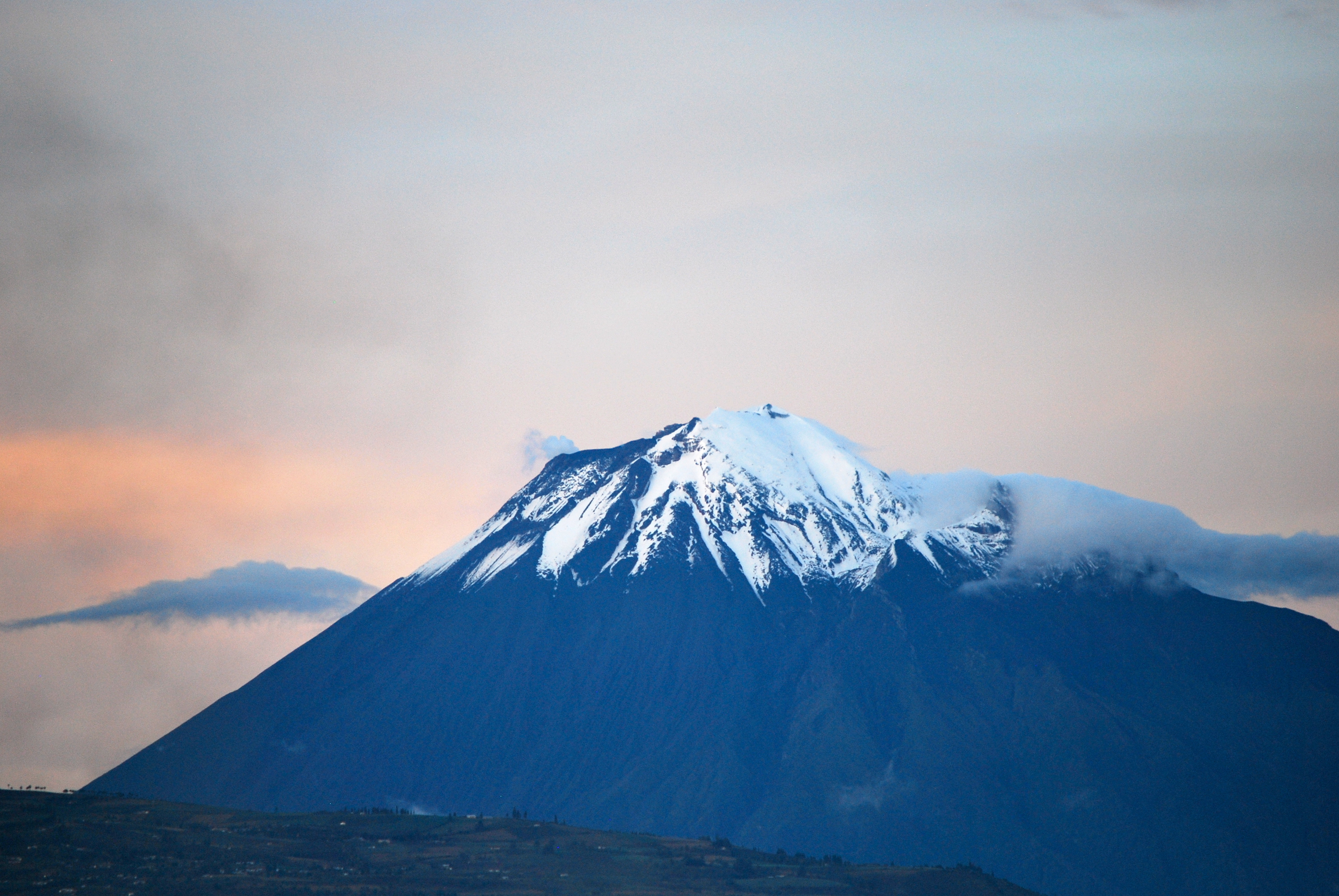
The volcano's current state
After the 1999–2016 eruptive cycle, Tungurahua is in a phase of low activity, according to the reports of the Instituto Geofísico. It is still an active, monitored volcano; you should always check the updated official reports before any close visit or ascent.
Source: https://www.igepn.edu.ec/

📚 Bibliography

  • Wikipedia (ES) — «Tungurahua (volcán)»: https://es.wikipedia.org/wiki/Tungurahua_(volc%C3%A1n)
  • Wikipedia (EN) — «Tungurahua»: https://en.wikipedia.org/wiki/Tungurahua
  • Instituto Geofísico de la Escuela Politécnica Nacional (IG-EPN) — Volcán Tungurahua: https://www.igepn.edu.ec/tungurahua
  • Global Volcanism Program (Smithsonian) — Tungurahua, reporte de agosto 2006: https://volcano.si.edu/showreport.cfm?wvar=GVP.WVAR20060816-352080
  • Global Volcanism Program (Smithsonian) — Tungurahua, reporte de diciembre 2006: https://volcano.si.edu/showreport.cfm?doi=10.5479/si.GVP.BGVN200612-352080
  • NASA Earth Observatory — «Eruption of Tungurahua»: https://science.nasa.gov/earth/earth-observatory/eruption-of-tungurahua-6858/
  • Journal of Applied Volcanology — «The scientific–community interface over the fifteen-year eruptive episode of Tungurahua Volcano, Ecuador» (2015): https://link.springer.com/article/10.1186/s13617-015-0025-y
  • Wikipedia (ES) — «Baños de Agua Santa»: https://es.wikipedia.org/wiki/Ba%C3%B1os_de_Agua_Santa
  • Wikipedia (ES) — «Parque nacional Sangay»: https://es.wikipedia.org/wiki/Parque_nacional_Sangay

❓ Frequently asked questions

Why do they call Tungurahua the 'Black Giant'?+
For its imposing volcanic cone and its intense eruptions, especially those it resumed in 1999 and kept up for years, with ash columns, explosions and incandescent flows at night. It's one of Ecuador's most active volcanoes. Its Kichwa name is usually translated as 'throat of fire'.
Can you climb to the summit?+
The ascent of Tungurahua is a mountaineering climb and it depends entirely on the volcano's activity status: in periods of eruption or alert, access is usually restricted or forbidden for safety. When conditions allow, it is done with certified mountain guides (approx. USD 120–250 per person). You always have to check the current situation with the Instituto Geofísico and the authorities.
How can you see the volcano safely and what does it cost?+
The usual, safe way is to view it from the viewpoints on the heights above Baños. The Bellavista viewpoint has open access (free on foot). The Casa del Árbol costs about USD 1.50 per adult. You can also go up by taxi/pickup (USD 15–25 round trip with waiting time) or on a tour (USD 8–20). In periods of activity, at night you can see the incandescent glow.
How much do the Baños hot springs cost?+
The Termas de la Virgen, the most central and famous, cost around USD 3–4 per adult and USD 2 for children and senior citizens (2025), with daytime and evening hours. The water is heated by the volcano. Bring a swimsuit, a towel and cash. Check the rate when you visit.
How do I get to Baños from Quito and what does it cost?+
From Quito there are interprovincial buses via Ambato: the Quito–Ambato leg costs about USD 5 and Ambato–Baños about USD 1, with a total journey of 3 to 3.5 hours. Some cooperatives (such as Expreso Baños) run more direct services. Baños is the base for visiting the volcano and its surroundings.
When is the best time to visit?+
The dry season (June to September) offers more clear days for seeing the volcano. In any case, it's worth checking the volcanic activity status and the recommendations of the Instituto Geofísico (IG-EPN) before planning the visit, and bringing warm clothes for the heights.
How do I get around Baños and how do you pay for transport?+
Baños is a small and very walkable town, so most of the attractions in the center (hot springs, market, square) are done on foot. There is a small city bus (Compañía Luna Sánchez) that costs USD 0.30 and is paid in cash to the driver: there's no rechargeable card and no payment app. To get up to the heights (Runtún, Casa del Árbol) the practical options are a taxi/pickup (USD 15–25 round trip with waiting time), a tourist chiva (USD 5–8) or a tour. There's no Uber and no Cabify in Baños; you catch taxis in the street. To plan long-distance bus routes and timetables Google Maps works well, and the local app banos.app is for buying tickets and tours.
Is Tungurahua erupting right now? Is it dangerous to visit Baños?+
No. After the long 1999–2016 eruptive cycle, Tungurahua is calm: the Instituto Geofísico (IG-EPN) keeps it on white alert / very low activity and does not anticipate a reactivation in the short or medium term (July 2026). Visiting Baños and the viewpoints is completely safe. Even so, since it's an active volcano monitored 24/7, it's worth checking the official IG-EPN report before a climb or before getting very close to the cone.
Sources consulted (8)
Still planning?
Explore more destinations in Ecuador
See all destinations →
Advertisements
Image credits
Photos from Wikimedia Commons, each under its own licence (CC BY, CC BY-SA or public domain). Open each file to see its author and licence.
Volcán Tungurahua Riobamba - Ecuador