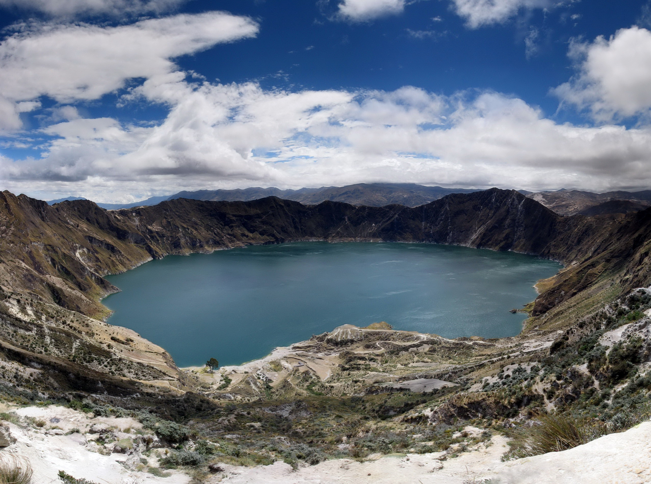
Some viewpoints take your breath away, and the one over Laguna Quilotoa is one of them. After a journey along highland roads, you reach the edge of an enormous crater and suddenly, far below, the lake appears: a mirror of impossibly turquoise water, enclosed by the walls of a volcanic caldera at almost 3,900 meters. The color shifts with the light and the clouds —from emerald green to deep blue— and the silence of the páramo wraps around everything. It is one of the most unforgettable sights in the Ecuadorian Andes.
Quilotoa was born of a cataclysmic eruption several centuries ago, which emptied the volcano and left this giant caldera, later filled by water. Today it is the heart of a territory of Kichwa Indigenous communities, who live from farming, crafts and, increasingly, from respectful community tourism. Walking down to the water's edge, paddling a kayak on the lake, following the crater rim or walking from village to village along the famous 'Quilotoa Loop' are all different ways of letting this place get hold of you.
This guide covers Quilotoa with a practical, warm eye: how to get there from Latacunga or Quito, what to see and do at the lake and around it, how to tackle the descent and the climb back up while looking after yourself at altitude, what the Quilotoa Loop is, where to sleep and eat, and how to support Kichwa community tourism. With a bit of warm clothing, water and respect for the mountain and its people, Quilotoa hands you one of the finest days of any trip through Ecuador's highlands.
The name 'Quilotoa' is usually linked to Andean words related to 'tooth' or 'molar' and to water, a poetic reference to this lake locked inside a crater. Its origin, though, was violent: Quilotoa is a volcanic caldera formed by a cataclysmic eruption that geological studies place around the 13th century (some 800 years ago, around the year 1280). That huge explosion threw out enormous quantities of material, emptied the volcano's chamber and caused the cone to collapse, leaving the giant caldera some 3 km across that filled with water over time, giving rise to today's lake. Its water, rich in minerals and dissolved volcanic gases, owes its characteristic turquoise color to that composition. Long before and long after the eruption, the region was inhabited by Andean peoples; today its surroundings belong to Kichwa Indigenous communities, heirs to a long farming and craft tradition in the highlands. In recent decades Quilotoa has gone from a remote corner to one of Ecuador's tourism icons and the axis of a community tourism model that seeks to keep the benefits of visitors in the hands of the communities themselves. The full story is on our history page.
Read the full history ↓The province of the Avenue of the Volcanoes: Panzaleo territory dominated by Cotopaxi, one of the highest active volcanoes in the world, with the turquoise Quilotoa lagoon, the Mama Negra of Latacunga, the paintings of Tigua and the Indigenous markets of Saquisilí and Pujilí.
Read the history of Cotopaxi →Some places make no sense on your own; with someone explaining them, they change completely. We look ours up on Civitatis: guided in Spanish and booked online with no fuss. They have 17 activities in Banos. Three are below so you get the idea: tap any of them and they all open.
They depart from Banos, 80 km away. If you book from this link we earn a commission and you pay no more.
No exact prices: a scale from $ (budget) to $$$$$ (luxury), with 2-3 options per category.
Origins, formation and what the sources say.
It is hard to believe that this mirror of turquoise water, serene today at the bottom of its crater, is the scar of one of the most violent eruptions in the Andes in historical times. And it is hard to believe, too, that its very name may carry an echo of that fury. The place name 'Quilotoa' has Andean roots and, as with many highland Ecuadorian place names, its exact etymology is open to interpretation. The most widespread proposals link it to Andean-language words related to 'tooth' or 'molar' and to water, an evocative image for this lake locked like a jewel in the hollow of a crater, between the jagged walls of the caldera.
Beyond linguistic precision, the name reflects the way the peoples who lived and still live in the region see it: for them, the lake was not a mere geographical feature but a place with an identity of its own within a landscape loaded with meaning. Large high-altitude lakes, like volcanoes, tended to hold a place in the Andean symbolic world, associated with water, fertility and the forces of nature.
Today the name Quilotoa refers both to the lake and its crater and to the Indigenous community living on its rim. The survival of the name, Andean in root, is a reminder that this spectacular landscape has a human history as deep as its geological one, and that the lake has been part of the life and culture of the peoples of the area for centuries.
Quilotoa is, above all, a volcanic caldera: a large depression formed by the collapse of a volcano after an eruption of enormous magnitude. Geological studies place that event around the 13th century, near the year 1280 (some 800 years ago): a cataclysmic eruption, among the most violent in the region in geologically recent times, which changed the landscape forever.
In that explosion the volcano threw out immense volumes of material —ash, pumice and pyroclastic flows— that covered wide areas and, according to the studies, left deposits detectable a long way off. As the magma chamber emptied, the volcano's structure collapsed in on itself, creating the giant caldera some 3 kilometers across that today holds the lake. Over time, rainwater and seepage filled that depression, giving rise to today's lake, which is considerably deep.
The characteristic turquoise color of the water is a direct consequence of this volcanic origin: the lake contains dissolved minerals and volcanic gases, and there is in fact still activity associated with the volcanic system, with fumaroles and emissions on the bottom. Although it is seen today as a serene and beautiful place, Quilotoa is the scar —turned into a wonder— of an extremely violent natural episode.
The Quilotoa region has been inhabited by Andean peoples since long before the great eruption and, of course, long before the Spanish arrived. The valleys, páramos and slopes of this part of the central highlands were the territory of populations devoted to high-altitude farming, herding and using the resources of the mountain, in a demanding but rich environment.
With the Inca expansion northward in the 15th century, the area was absorbed into the Tahuantinsuyo, and after the Spanish conquest it became part of the colonial fabric, with its haciendas, its evangelization and its deep social transformations. Even so, the Indigenous communities of the region kept much of their language —Kichwa—, their forms of community organization and their farming and craft traditions.
Today the area around Quilotoa belongs to Kichwa Indigenous communities, heirs to that long history. Life turns on the land (potatoes, broad beans, barley, herding), the community and, increasingly, tourism. The area is also the cradle of Tigua art, a naïf painting tradition on sheepskin that depicts Andean life, festivals, myths and the landscapes of the region, and which has become an artistic emblem of Ecuador. That living Indigenous presence is an essential part of Quilotoa's identity.
Quilotoa is not an isolated phenomenon but part of the intense volcanism of the Ecuadorian Andes, a region where the collision of tectonic plates (the Nazca plate subducting under the South American one) produces a long chain of volcanoes. Ecuador has one of the highest densities of active and potentially active volcanoes in the world, and the so-called 'Avenida de los Volcanes' runs the length of the central highlands, where Quilotoa sits.
Geologically, Quilotoa is a dacitic volcano whose eruptive history culminated in the great caldera-forming eruption. Unlike perfect-cone volcanoes such as Cotopaxi, Quilotoa appears today as an enormous caldera occupied by a lake, one of the shapes a volcanic landscape takes after collapsing eruptions. The system is still considered potentially active, and fumaroles and gas emissions have been recorded in the lake.
This geological dimension is a fundamental part of Quilotoa's story: the lake that so captivates visitors is in fact the visible testimony of deep forces in the Earth. Understanding its volcanic origin helps you appreciate the place better: every time you look out over the crater, you are contemplating the mark of one of the great recent geological events of the Ecuadorian Andes, now turned into one of the country's most beautiful landscapes.
For a long time Quilotoa was a remote, hard-to-reach place, known mainly to the communities of the area and to a few adventurous travelers who arrived after a long journey on difficult roads. Better access roads and the growing fame of its turquoise lake changed that in recent decades, turning Quilotoa into one of Ecuador's tourism icons and an almost obligatory stop on highland routes.
That boom brought a particular model with it: community tourism. Rather than falling into the hands of large outside companies, much of the service at Quilotoa —entry to the lake, the guesthouses, the canteens, the kayak and mule rentals, the crafts and the guiding— is run by the Kichwa Indigenous community itself. The idea is that the benefits of tourism stay in the territory and strengthen local families, a fairer and more respectful way of traveling.
Alongside it, the 'Quilotoa Loop' took hold: the walking circuit linking villages such as Sigchos, Chugchilán and Quilotoa, which became famous among trekking lovers. This route on foot, supported by family-run guesthouses in the villages, spreads the benefits of tourism across the whole area and lets travelers see Andean life up close. So today's Quilotoa combines an extraordinary geological landscape with a human and cultural experience: meeting the Kichwa communities who look after this unique corner of the Andes.