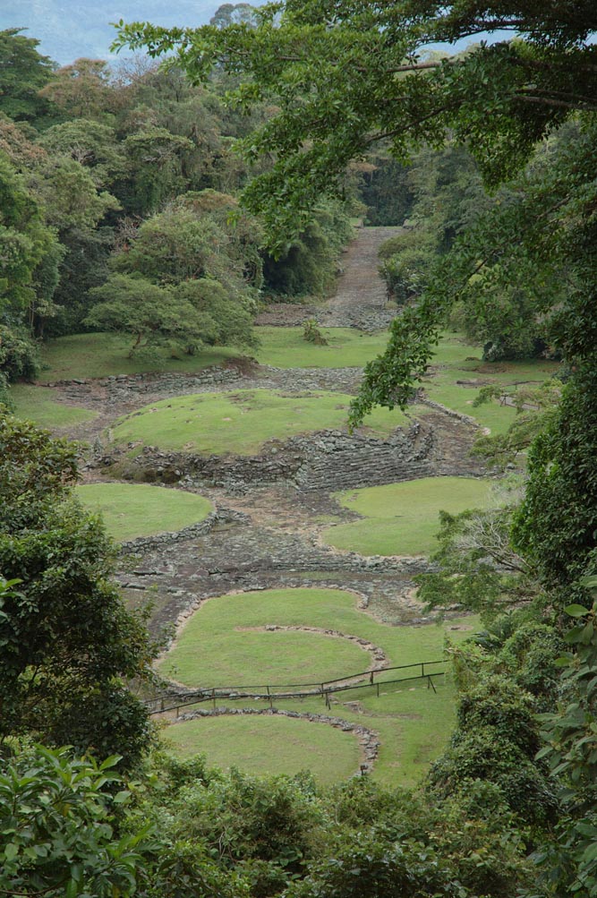
Guayabo National Monument is the best-kept secret of Costa Rican archaeology: in a country famous for its volcanoes, beaches and jungles, this is where the most important known pre-Columbian city hides, tucked into the moist forest on the flanks of Turrialba Volcano. Walking its cobbled causeways, its still-working aqueducts and its circular mounds is a glimpse of a civilization that flourished for centuries and still keeps plenty of mysteries.
Unlike the great stone cities of Mexico or Peru, Guayabo does not impress through sheer scale but through quiet sophistication: a hydraulic system that has been channeling spring water for more than a thousand years, stone causeways that connected the city with distant regions, circular bases on which wooden dwellings once stood, and enigmatic petroglyphs. In 2009 it was named an International Historic Civil Engineering Landmark by the American Society of Civil Engineers (ASCE), an unusual recognition for an archaeological site.
This guide covers the essentials of Guayabo with a practical eye: how to get there from San José or Turrialba, what you see along the route, how to make the most of the viewpoint and the site museum, and how to combine the visit with the adventures of the Pacuare area and Turrialba Volcano. It is a different kind of stop, perfect for anyone who wants to add history and culture to a trip through Costa Rica.
Guayabo was a pre-Columbian city occupied roughly between 1000 BC and AD 1400, at its height between AD 800 and 1400, when it is estimated to have held some 10,000 inhabitants. It belonged to the archaeological region known as the Atlantic Watershed or Central Highlands, culturally linked to the historical area running from central Costa Rica southward. Its people were hierarchical chiefdom societies who mastered hydraulic engineering, stone construction and long-distance trade. The city was organized around circular mounds (bases on which structures of wood and palm were raised), cobbled causeways, aqueducts, water storage tanks and tombs. For reasons still under debate —social pressures, conflict, environmental change or disease—, the site was abandoned around AD 1400, before the Spanish arrived. It lay hidden under the jungle for centuries. In the late 19th century, the explorer Anastasio Alfaro made the first observations, and systematic excavations began in the 20th century, especially through the archaeologist Carmen María Murillo and the Universidad de Costa Rica. In 1973 it was declared a National Monument and, in 2009, an International Historic Civil Engineering Landmark by the ASCE, above all for its remarkable hydraulic system, which still carries water today. The full story is on our history page.
Read the full history ↓The first capital of Costa Rica, founded in 1563: the country's colonial cradle and the heart of its faith, home to the Basilica of the Virgin of Los Ángeles —the 'Negrita'—, a land of giant volcanoes, coffee valleys and of the pre-Columbian monument of Guayabo, the oldest stone city in the country.
Read the history of Cartago →A local guide tells you in half an hour what no sign at the site will ever explain. We look ours up on Civitatis: guided in Spanish and booked online with no fuss. They have 17 activities in San Jose. And there are free tours here: you book without paying and tip the guide whatever you think at the end, so trying one costs you nothing. Three are below so you get the idea: tap any of them and they all open.
They depart from San Jose, 43 km away. If you book from this link we earn a commission and you pay no more.
No exact prices: a scale from $ (budget) to $$$$$ (luxury), with 2-3 options per category.
Origins, formation and what the sources say.
More than a thousand years ago, someone in these mountains designed a stone aqueduct so precise that today, well into the 21st century, it still carries spring water without a single modern repair. That astonishing detail sums up why Guayabo National Monument, hidden on the flanks of Turrialba Volcano (province of Cartago, at about 1,000 meters of altitude), is the largest and most important archaeological site in Costa Rica. It protects the remains of an ancient pre-Columbian city that was a political, religious and trading center of great importance in the center of what is now Costa Rica.
What makes Guayabo exceptional is not the height or the sheer scale of its buildings —there are no pyramids or great stone temples as in Mesoamerica or the Andes— but the sophistication of its urban planning and its engineering. The city was organized around circular mounds (stone bases on which structures of wood and palm were raised), connected by cobbled causeways, and served by a complex system of aqueducts, channels and water storage tanks that still works today.
Archaeologists estimate that at its height Guayabo may have held several thousand people —some estimates go as high as 10,000 inhabitants—, which makes it the main known pre-Columbian settlement in the country. Only a fraction of the site has been excavated; many structures remain unstudied under the surrounding forest, which keeps Guayabo an open field of research full of unanswered questions.
Human occupation of Guayabo stretched over more than two millennia. Archaeologists usually divide this long history into phases. In the earliest periods, from roughly 1000 BC, the site was occupied by small farming communities who worked the land, making use of the fertile volcanic soils, the abundance of water and the resources of the forest.
The great growth came later. Between roughly AD 800 and 1400, during what specialists call the Cartago period or the phase of greatest development, Guayabo turned into a complex chiefdom center: a hierarchical society, with chiefs and elites at the top, specialists (builders, craftspeople, religious leaders) and a general population devoted to farming. In this stage the large mounds, the causeways, the aqueducts and the water tanks you see today were built, evidence of a social organization capable of mobilizing a great deal of coordinated labor.
Guayabo was not an isolated site: it was part of a regional network of villages and centers connected by roads, trading in goods such as gold, jade, pottery, salt and food. Its strategic position, between the highlands and the lowlands of the Caribbean side, made it a key point in that exchange network in central Costa Rica.
The most admired feature of Guayabo, and what gave it international fame, is its hydraulic system. The ancient inhabitants designed and built a network of open and closed aqueducts, stone channels, storage tanks and drains that captured water from nearby springs and carried it by gravity into the heart of the city, distributing it for drinking and keeping clean water separate from wastewater.
What is extraordinary is the durability and efficiency of this work: more than a thousand years after it was built, much of the system still functions, and the water still runs through the same stone channels. That shows a deep knowledge of topography, gradients and water management, comparable to that of other great hydraulic cultures of the continent. The site's urban planning —with its hierarchical mounds, plazas, causeways and its integration into the natural setting— reveals deliberate design and remarkable engineering thinking.
That recognition became formal in 2009, when the American Society of Civil Engineers (ASCE) named Guayabo an International Historic Civil Engineering Landmark, an honor it shares with works such as the Eiffel Tower or the Panama Canal. It is the only site in Costa Rica with that distinction, and it underlines that the value of Guayabo lies as much in engineering as in archaeology.
One of the great riddles of Guayabo is its abandonment. Around the year AD 1400 —that is, before the Spanish reached the region—, the population left the site, which was gradually swallowed by the jungle. The reasons for that abandonment are not known for certain, and archaeologists work with several hypotheses, none of them definitive.
Among the most discussed explanations are: social pressures or internal conflict within the chiefdom society; wars or disputes with neighboring groups; environmental change or natural disasters (the closeness of Turrialba Volcano has led to speculation about possible eruptions or related events); the exhaustion of resources; or epidemiological factors. It was probably a combination of causes rather than a single factor.
What is certain is that, when the Spanish arrived in Costa Rica in the 16th century, Guayabo was already uninhabited and hidden. The site remained forgotten for centuries, known only to local residents, until 19th-century scientific curiosity and 20th-century research rescued it from oblivion. That information gap —there are no Spanish chronicles describing the living city— is part of what keeps the mystery alive: almost everything we know comes from archaeology, not from written testimony.
Although local people always knew there were 'stones' and mounds in the area, the scientific rediscovery of Guayabo began in the late 19th century. The Costa Rican naturalist and explorer Anastasio Alfaro, a key figure in the country's science and linked to the Museo Nacional, made some of the first observations and collections in the area toward the last decades of that century, drawing attention to the value of the site.
Systematic research, however, came in the 20th century. Over several decades, different archaeologists and expeditions excavated and mapped the site. A fundamental role was played by the archaeologist Carmen María Murillo Herrera and, more broadly, by the Universidad de Costa Rica and the Museo Nacional, which led excavation campaigns, documented the structures and developed the chronologies used today. This research revealed the scale and complexity of the settlement, until then unsuspected.
Despite all that work, it is reckoned that only a portion of the total site has been excavated and studied. Much of Guayabo remains under the forest, awaiting future research, which means that what we know about the ancient city will keep growing over time.
Official recognition of Guayabo's value came in 1973, when the Costa Rican state declared it a National Monument, giving it legal protection and placing it under public administration. Today it is managed by the Sistema Nacional de Áreas de Conservación (SINAC), within the Área de Conservación Central, which looks after both the archaeological heritage and the premontane moist forest surrounding it.
The protection covers an area that combines the archaeological zone proper with a natural setting rich in biodiversity: birds, mammals, butterflies and lush vegetation. That double status —cultural and natural heritage— makes Guayabo a singular site within the country's protected-area system, better known for its volcanoes and national parks than for its archaeology.
The second great milestone was 2009, when the American Society of Civil Engineers (ASCE) named it an International Historic Civil Engineering Landmark, in recognition of its hydraulic system. Thanks to these designations, to the work of SINAC and to ongoing research, Guayabo has established itself as a destination that brings together history, science and nature, and as a symbol of Costa Rica's pre-Columbian past: proof that, long before the Europeans arrived, a civilization capable of great engineering works flourished in these mountains.