Viajá con Gus
Home › Cameroon › Ring Road
Ring Road
🇨🇲 Cameroon · Anglophone North-West highlands (advised against)

Ring Road

🪪 What do I need to enter Cameroon?Pick your citizenship and we tell you the visa, the days and the paperwork, with the official source.

By leaving your email and citizenship you agree to receive the documents you asked for and weekly travel news. You can unsubscribe whenever you want. How we handle your data.
Jump to what you need
📌Safety warning
The Ring Road runs entirely through Cameroon's anglophone North-West Region, which has been badly affected since 2016 by an armed separatist conflict (the 'Anglophone crisis'). The United States, the United Kingdom, Australia, Canada and other governments advise against ALL travel to the North-West and South-West regions because of the risk of armed clashes, kidnapping for ransom, roadside ambushes, explosive devices, curfews and 'ghost town' days. Driving the Ring Road means crossing rural areas that are especially dangerous. This guide describes it for its extraordinary scenery and culture, but TODAY the circuit cannot be travelled safely. Always check your country's official travel advice and do not travel to the area while the conflict lasts.
📌What it is
The Ring Road (National Road 11, RN11) is a scenic circuit of roughly 350-365 km that forms a loop through the highlands of north-west Cameroon, linking the region's main towns. It starts and ends in Bamenda, the regional capital, and crosses mountains, grassfields plateaus, crater lakes, waterfalls, villages and traditional kingdoms ('fondoms'). In normal times, it was one of Cameroon's great nature and culture routes.
📌Best time (in normal times)
Under normal security conditions, the dry season (November to February) was the only sensible time to do the Ring Road: outside the rains, the dirt stretches — some of them very demanding — are passable. During the rainy season (March to October), much of the loop turns into a mud bath that is barely passable. Today, however, it is security — not the weather — that makes the route unworkable at any time of year.
📌Route
The loop passes through Bamenda, Bafut, Wum, Nyos, Kumbo, Nkambe and Ndop, among other places, and back to Bamenda. It requires an off-road vehicle: parts of the circuit (such as the Wum-Nkambe stretch) are mountain tracks in variable condition, suitable only for 4x4s.
📌Language
The North-West is an anglophone region: people speak English, Cameroonian Pidgin and many local grassfields languages (Kom, Nso, Aghem and others). This English-speaking identity lies at the root of the current conflict.
📌Currency
The Central African CFA franc (XAF), pegged to the euro (1 € = 655,957 XAF). In mid-2026 the US dollar is worth around 575 XAF.
📌How it was done (in normal times)
The circuit was organised from Bamenda, with a 4x4 and a driver/guide, over 2 to 4 days with overnight stops in the towns along the loop. Today, travel in the region is badly disrupted by insecurity, roadblocks and ambushes; the circuit cannot be travelled.
💱 XAF exchange rate
Loading rate…
🌤️ Weather in Ring Road
Loading weather…

In normal times, the Ring Road is one of Cameroon's great nature journeys: a loop of more than 350 kilometres through the North-West highlands that links mountains, green plateaus, crater lakes, waterfalls and traditional kingdoms. Starting from Bamenda, the circuit crosses some of the country's most spectacular landscapes and a string of 'fondoms' (kingdoms) with their palaces, masks and ceremonies.

But today the Ring Road cannot be travelled safely. It runs entirely through the North-West Region, one of Cameroon's two anglophone regions, which have been caught up since 2016 in a serious armed separatist conflict. The rural areas the loop crosses are among the most dangerous, with clashes, kidnappings and ambushes. All major governments advise against any travel to the region. This guide describes the Ring Road for its great beauty and cultural value, but with a clear warning: for now, it is a route you can only admire on the map.

On these pages we explain what the Ring Road is and what it offers: its mountain and grassfields scenery, its crater lakes (including the tragically famous Lake Nyos), its waterfalls, its traditional kingdoms and its cool highland climate, along with the background of the Anglophone crisis that makes it impassable today. It is a way to get to know one of Cameroon's great routes and to understand why, for the time being, it has to wait for better times — always checking official travel advice before making any plans.

📖 History of Ring Road

The Ring Road was laid out and improved in the 20th century to connect the towns of the North-West highlands, joining the region's various divisions and kingdoms in a single loop. It runs through a volcanic landscape of mountains and crater lakes, among them Lake Nyos, sadly famous for the 1986 gas disaster that killed more than 1.700 people. In normal times it was one of the country's great tourist circuits; since 2016 the Anglophone conflict has made it impassable. The full story — from the geology to the current crisis — is told on our history page.

Read the full history ↓

🏛️ Ring Road is in the anglophone Northwest highlands

The fondoms of the highlands: the kingdom of Bafut immortalised by Gerald Durrell, the city of Bamenda, cradle of the opposition, and the scenic Ring Road, all now marked by the anglophone crisis.

Read the history of The anglophone Northwest highlands →

🗺️ What to see

1
Lake Nyos
A crater lake sadly famous for the 1986 gas disaster, set in an imposing volcanic landscape.
Leer más ↓
Lake Nyos, in the north of the loop, is a crater lake of serene beauty with a tragic history. In August 1986, a sudden release of carbon dioxide that had built up at the bottom of the lake (a 'limnic eruption') formed a gas cloud that flowed down the valleys and suffocated more than 1.700 people and their livestock in nearby villages, in one of the strangest and deadliest natural disasters of the 20th century. Degassing systems have since been installed to prevent it from happening again. Beyond its history, the lake, wedged between walls of volcanic rock, is a place of powerful scenery and a testament to the volcanic nature of the North-West highlands. In normal times, it was a striking stop on the circuit, combining beauty and memory. Warning: the area is currently advised against for safety reasons. This description is geographical and historical.
ℹ️ Location: Northern Ring Road, near Wum · Historical event: 1986 gas disaster (more than 1.700 deaths) · Status: Region advised against due to the Anglophone conflict · Type: Volcanic crater lake
2
Mount Oku and Lake Oku
One of the highest mountains in West Africa (about 3.000 m), with a crater lake and highland forests of great ecological value.
Leer más ↓
Mount Oku, at about 3.000 metres, is the second-highest peak in West Africa after Mount Cameroon, and one of the great natural landmarks of the Ring Road. Its slopes hold the Kilum-Ijim mountain forests, one of the last remnants of Afromontane forest in the region, a refuge for endemic species such as Bannerman's turaco and for rich plant life, protected by community conservation projects. The mountain's crater holds Lake Oku, a lake sacred to local communities, surrounded by forest and mist. The Oku area is also famous for its white honey, a highly prized product. In normal times, Mount Oku offered superb walks through highland forest, with fresh air and mountain views. Warning: the region is currently advised against because of the conflict; this description is natural and cultural.
ℹ️ Altitude: About 3.000 m (2nd-highest peak in West Africa) · Nature: Kilum-Ijim Afromontane forest; sacred crater lake · Status: Region advised against for safety reasons · Local speciality: Oku white honey
3
Menchum Falls
A spectacular drop of the Menchum River between rock walls, one of the great natural highlights of the loop.
Leer más ↓
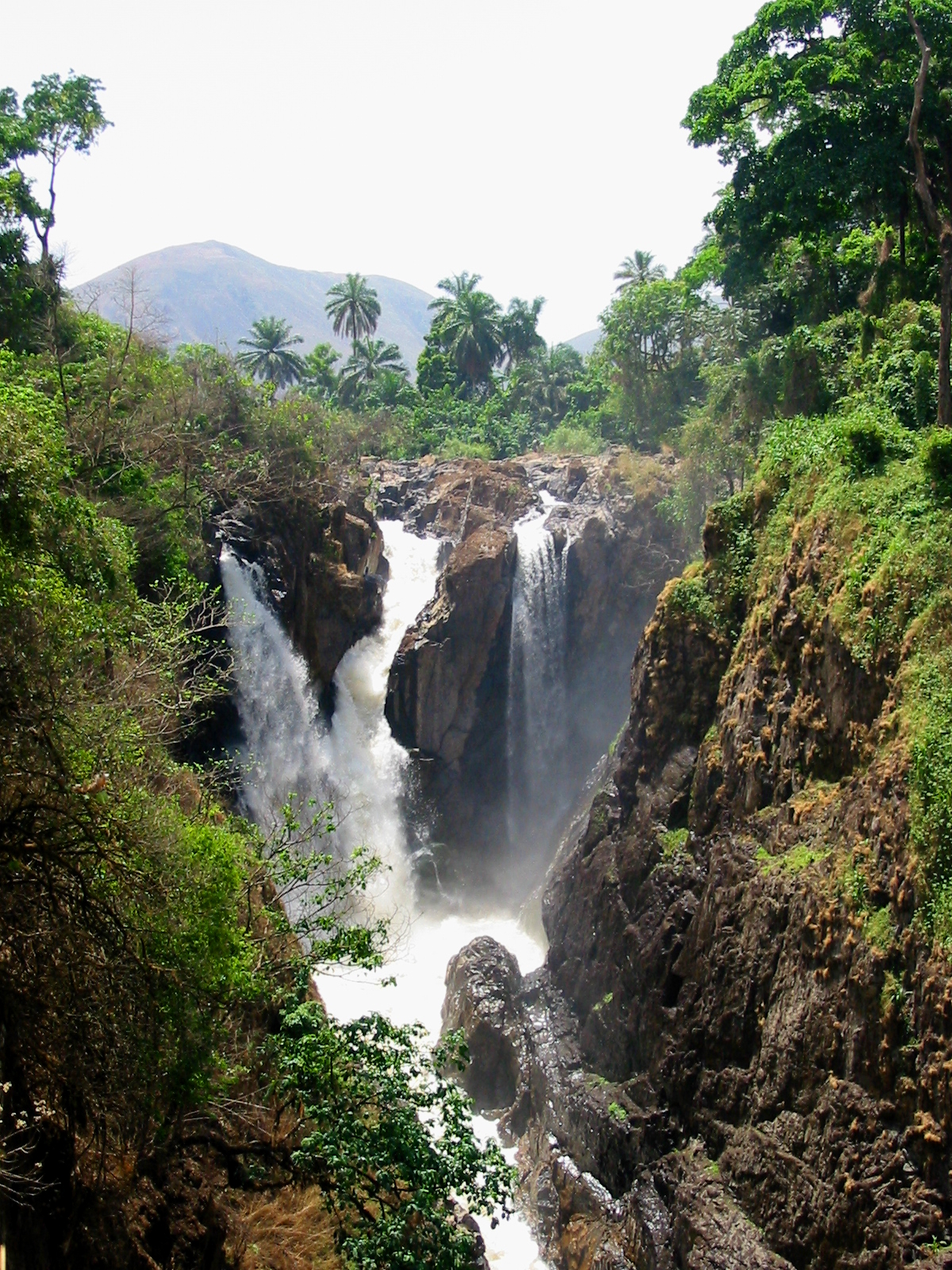
Menchum Falls, between Bamenda and Wum, is one of Cameroon's most dramatic waterfalls: the Menchum River plunges powerfully, carving into the rock in a mountain setting, about an hour's drive from Bamenda. In normal times, it was a classic stop at the start of the Ring Road, with viewpoints overlooking the drop. The falls are especially powerful at the end of the rainy season, when the river is at its fullest. The surrounding landscape of green hills and volcanic rock is typical of the North-West highlands. Warning: the area is currently advised against for safety reasons. This description is geographical.
ℹ️ Location: Between Bamenda and Wum, ~1 h from Bamenda · Type: Waterfall on the Menchum River · Status: Region advised against due to the Anglophone conflict · Best flow (in normal times): End of the rainy season
4
Kumbo and the Nso kingdom
The second city of the North-West and seat of the powerful Nso 'fondom', with its Royal Palace and famous horse race.
Leer más ↓
Kumbo, in the east of the loop, is the second city of the North-West Region and the seat of the Nso 'fondom', one of the most powerful and influential traditional kingdoms of the grassfields. Its Royal Palace, seat of the 'fon' of Nso, and its culture — with secret societies, masks and ceremonies — made it, in normal times, a standout cultural stop on the circuit. Kumbo is also famous for its annual horse race ('Nso Cultural Week' and the 'horse race'), a festive tradition that brought together riders and crowds in a colourful display very typical of the North-West. The town, high up and with a cool climate, is also an important Catholic centre in the region. Warning: the region is currently advised against because of the conflict; this description is cultural and historical.
ℹ️ Location: Eastern Ring Road; 2nd city of the North-West · Culture: Seat of the Nso 'fondom'; annual horse race · Status: Region advised against for safety reasons · Feature: High altitude, cool climate, Catholic centre
5
Grassfields kingdoms, plateaus and villages
The string of 'fondoms', green plateaus and traditional villages along the loop, the heart of North-West culture.
Leer más ↓
The great appeal of the Ring Road, beyond its natural landmarks, is the string of grassfields kingdoms and villages it passes through: Bafut, Kom (with its famous Laikom Royal Palace and the tradition of the 'afo-a-kom', a celebrated royal statue), Nso in Kumbo, Bali and others. Each has its sacred 'fon', its royal compound, its masks and its ceremonies, in a cultural mosaic comparable to that of the Bamileke in the West Region but with its own anglophone identity. Between kingdoms, the circuit runs across rolling plateaus of pasture, fields and forest, with wide views, villages of traditional houses and an intense rural life. In normal times, it was a journey through a deep, green and culturally very rich Cameroon. Warning: all these places are currently advised against because of the Anglophone conflict; their description is cultural, historical and geographical.
ℹ️ Kingdoms on the loop: Bafut, Kom (Laikom), Nso (Kumbo), Bali and others · Landscape: Grassfields plateaus, villages, mountains and forests · Status: Region advised against for safety reasons · Duration (in normal times): 2- to 4-day circuit
📶I have never landed without internet. I arrive and my phone connects to the strongest network in the country I am visiting: I can say I landed, sort out transport, book tours and keep posting, at a seriously good price. I always use the Maya eSIM — check their plans by clicking the banner.See plans →Maya Mobile eSIM — connect before you land
What nobody tells you

💵 Prices

Tickets

TypePrice
Fondoms del anillo (Nso, Kom, Bafut...) en tiempos normalesVisiting fee of around 2.000-5.000 XAF per palace (approx. US$ 3,50-9); subject to the destination becoming safe to visit again (check)
Sitios naturales (Nyos, Oku, Menchum)Free access or a tip for local guides (in normal times)
Estado actualCircuit ADVISED AGAINST for safety reasons (Anglophone conflict)
🔄 updated monthlyOfficial / reference values · double-check when buying

Activities and tours

Full Ring Road circuit by 4x4 with a guide (in normal times)
Duration2 to 4 days
OperatorNorth-West operators (from Bamenda)
Price
2- to 4-day trip with vehicle, driver/guide and overnight stays; price depends on the route; not currently operating for safety reasons
Walks on Mount Oku and in the Kilum-Ijim forest (in normal times)
Duration1 day
OperatorOku community projects
Price
With a community guide, depending on the route; not currently operating for safety reasons
Visits to fondoms and ceremonies on the loop (in normal times)
DurationVariable
OperatorPalace guides
Price
Visiting fee of around 2.000-5.000 XAF per palace (approx. US$ 3,50-9); not currently operating for safety reasons
🔄 updated monthlyOfficial / reference values · double-check when buying

🚌 How to get there and distances

Getting around

4x4 vehicle with driver (in normal times)
DurationThe whole circuit
Price
Hire with driver per day, depending on the operator; essential given the state of the tracks; not currently operating for safety reasons
Notes
Parts of the loop (Wum-Nkambe) are mountain tracks suitable only for 4x4s; travel is currently badly disrupted by insecurity and ambushes
Motorbike taxi / local rural transport (in normal times)
PriceShort trips from a few hundred XAF, check
DurationVariable
Notes
Used by local people between villages; currently disrupted by the conflict
🔄 updated monthlyOfficial / reference values · double-check when buying

How to get there

RouteAirlines / operatorsAvg. priceDuration
Bamenda → start of the Ring Road (in normal times)Own vehicle or hired with driverDepending on the operator; the circuit starts and ends in Bamenda350-365 km circuit over 2 to 4 days
Douala/Yaoundé → Bamenda (circuit base, in normal times)Vatican Express, Amour MezamAround 6.000-9.000 XAF (approx. US$ 10-16), check6 to 7 h to Bamenda
Current status—Region advised against for safety reasons; routes affected by the Anglophone conflict—
🔄 updated monthlyOfficial / reference values · double-check when buying

🏨 Where to stay

No exact prices: a scale from $ (budget) to $$$$$ (luxury), with 2-3 options per category.

In normal times (towns on the loop)
Price$$$$$
Recommended options
Basic overnight stays in the towns on the circuit (Wum, Kumbo, Nkambe) and mid-range hotels in Bamenda as a base; the hotel trade is currently badly hit by the conflict
Current status
Price$$$$$
Recommended options
Circuit advised against for safety reasons; planning accommodation in the area is not recommended while the Anglophone crisis lasts

🍴 Where to eat

Cocina de los grassfields del Noroeste (en tiempos normales)
Price$$$$$
Options / signature dish
'Achu' with yellow soup, 'fufu' and 'njama-njama', 'kati kati', Oku white honey, in eateries in the towns on the loop; choice currently very limited because of the conflict
Estado actual
Price$$$$$
Options / signature dish
Circuit advised against; commercial life and the food scene in the region are badly hit by the crisis

📖 History of Ring Road

Origins, formation and what the sources say.

A ring on volcanic ground

The Ring Road runs through one of Cameroon's most remarkable landscapes: the volcanic highlands of the North-West, part of the great 'Cameroon line', a chain of volcanoes and uplands that cuts diagonally across the country from the Gulf of Guinea into the interior. This volcanic origin explains the ring's spectacular setting: high mountains such as Mount Oku (around 3,000 metres, the second-highest peak in West Africa), plateaus of fertile soil, and a constellation of crater lakes set into old volcanic vents.

Among those lakes is the sadly famous Lake Nyos, whose depths build up carbon dioxide of volcanic origin. In August 1986, a sudden release of that gas (a 'limnic eruption') formed a deadly cloud that rolled down the valleys and suffocated more than 1,700 people and thousands of cattle in nearby villages. It was one of the strangest and deadliest natural disasters of the 20th century. Degassing systems have since been installed to prevent it from happening again.

This volcanic terrain, with its cool highland climate, fertile soils and plentiful water, doesn't just give the Ring Road its scenery. It also explains why the North-West highlands have been, for centuries, one of the most densely populated and prosperous regions of Cameroon, and the home of dozens of traditional kingdoms.

The kingdoms of the grassfields

Long before any road existed, the North-West highlands were dotted with a dense network of traditional grassfields kingdoms ('fondoms'): Nso, Kom, Bafut, Bali, Bum and many others. Like their Bamileke neighbours in the West, these peoples had reached the mountains in waves of migration over several centuries and organised themselves into small hierarchical states, each ruled by a sacred 'fon' (king), with their own secret societies, masks and rituals.

Some of these kingdoms became very powerful and influential. The Nso 'fondom', with its capital at Kumbo, is one of the largest and most important in the North-West. The Kingdom of Kom, with its Royal Palace of Laikom, is famous for the 'afo-a-kom', a royal statue that was stolen and taken out of the country in the 1960s. Its recovery in the 1970s became a national cause and a symbol of African cultural dignity. Every kingdom along the ring has its own history, regalia and ceremonies.

This density of kingdoms, with their palaces, masks and living traditions, is the Ring Road's great cultural treasure. By linking the region's main towns and royal courts, the circuit offered, in normal times, an exceptional journey through this mosaic of small traditional states, comparable to Bamileke country but with the North-West's own English-speaking identity.

The route of the ring

The Ring Road as it is known today is a product of the 20th century. First under British administration and later under Cameroonian rule, a network of roads was gradually laid out and improved to connect the towns and districts of the North-West highlands, forming a ring of more than 350 kilometres centred on Bamenda, the regional capital. The road was designated National Road 11 (RN11) and became the backbone of the region's communications.

For decades, upgrading the ring was a recurring political promise and a real need for the development of a region that was agriculturally prosperous but hard to get around. Several sections were paved, while others, especially the mountain stretches such as Wum to Nkambe, remained dirt tracks in variable condition, passable only by 4x4 and often impassable during the long rainy season.

Despite these difficulties, the Ring Road became one of Cameroon's great tourist routes: a trip of several days combining spectacular nature (mountains, crater lakes, waterfalls, forests) with an extraordinary cultural richness, including visits to the traditional kingdoms of the North-West. It was one of the gems of Cameroonian tourism, and still far from crowded.

The Anglophone Crisis cuts the ring

Everything changed from 2016 onwards. Decades of built-up resentment in Cameroon's English-speaking regions, the North-West and the South-West, over perceived political, economic and cultural marginalisation by the French-speaking majority erupted that year in protests by lawyers, teachers and students. The harsh response of the security forces radicalised the conflict, and in 2017 separatist factions declared independence for a state they called 'Ambazonia', sparking a war between armed separatist groups and the army.

The North-West, which the Ring Road crosses from end to end, became one of the main theatres of violence. The rural areas of the ring, far from the urban centres, proved especially dangerous: clashes, roadside ambushes, kidnappings for ransom, explosive devices and 'ghost town' days that periodically bring life in the region to a standstill. Travelling the circuit, which runs precisely through those rural areas, became unthinkable.

The crisis has killed thousands of people and displaced hundreds of thousands. It has also hit the region's heritage: the Royal Palace of Bafut, on the ring, was attacked and looted in 2019. The kingdoms, mountains and lakes of the Ring Road fell out of travellers' reach, and with them one of the country's great tourist routes.

A route waiting for peace

Today the Ring Road is still, on the map, one of Cameroon's great potential journeys, but the conflict has made it impassable. All major governments advise against any travel to the North-West and South-West regions, and the rural areas of the ring are among the most dangerous in the whole country. It is not a destination you can visit while the crisis lasts.

This guide describes the Ring Road for its extraordinary natural beauty and cultural richness, and in the hope that one day peace will make it possible to travel its mountains, crater lakes and kingdoms again. The potential is huge: few places in Africa pack so much volcanic scenery and such a density of living traditional kingdoms into a single circuit.

In the meantime, caution comes first. Keep a close eye on official travel advice, which is updated regularly, and don't plan any trip around the ring while the destination is still advised against. Like all of English-speaking Cameroon, the Ring Road is waiting for better times to reopen to travellers. Always check the official advice before making any plans.

📚 Bibliography

  • Wikipedia (EN) — «Ring Road (Cameroon)»: https://en.wikipedia.org/wiki/Ring_Road_(Cameroon)
  • Wikipedia (EN) — «Lake Nyos»: https://en.wikipedia.org/wiki/Lake_Nyos
  • Wikipedia (EN) — «Mount Oku»: https://en.wikipedia.org/wiki/Mount_Oku
  • Wikipedia (EN) — «Afo-A-Kom»: https://en.wikipedia.org/wiki/Afo-A-Kom
  • Wikipedia (EN) — «Nso people»: https://en.wikipedia.org/wiki/Nso_people
  • Wikipedia (EN) — «Cameroon line» (volcanism): https://en.wikipedia.org/wiki/Cameroon_line
  • Wikipedia (EN) — «Anglophone Crisis»: https://en.wikipedia.org/wiki/Anglophone_Crisis
  • Dangerous Roads — The Ring Road of Cameroon: https://www.dangerousroads.org/africa/cameroon/12282-the-ring-road-of-cameroon-a-scenic-drive-through-north-western-mountains.html
  • U.S. Department of State — Cameroon Travel Advisory: https://travel.state.gov/content/travel/en/traveladvisories/traveladvisories/cameroon-travel-advisory.html
  • Britannica — «Cameroon»: https://www.britannica.com/place/Cameroon

❓ Frequently asked questions

Can you do the Ring Road today?+
Not safely. The circuit runs entirely through the anglophone North-West Region, caught up since 2016 in a serious armed separatist conflict. The United States, the United Kingdom, Australia, Canada and other governments advise against all travel to the North-West and South-West because of the risk of clashes, kidnappings, roadside ambushes, explosive devices, curfews and 'ghost town' days. The rural areas the loop crosses are among the most dangerous. Always check your country's official travel advice and do not travel to the area while the conflict lasts.
What could you see on the Ring Road?+
A loop of more than 350 km through the North-West highlands, with mountains (Mount Oku, about 3.000 m), crater lakes (Lake Nyos, Lake Oku), waterfalls (Menchum), highland forests and a string of traditional kingdoms ('fondoms') such as Nso in Kumbo, Kom in Laikom and Bafut, each with its palace, masks and ceremonies. It was one of Cameroon's great nature and culture routes.
What happened at Lake Nyos?+
In August 1986, Lake Nyos, a crater lake in the north of the ring, suddenly released a huge cloud of carbon dioxide that had built up at its bottom (a 'limnic eruption'). The cloud flowed down the valleys and suffocated more than 1,700 people and their livestock in nearby villages. It was one of the strangest natural disasters of the 20th century. Degassing systems were installed afterwards to stop it from happening again.
Did you need a 4x4?+
Yes. Parts of the Ring Road are paved, but long stretches (especially Wum-Nkambe) are mountain tracks in variable condition. You could only drive them in an off-road vehicle, and in practice they were impassable during the rainy season. The circuit took 2 to 4 days by 4x4 with a driver/guide from Bamenda. Either way, today the security situation rules it out.
When will it be possible to travel the route again?+
There's no date. It will depend on how the Anglophone conflict develops and on security returning to the region. The sensible thing is to follow your government's official travel advice, which is updated regularly, and not to plan any travel in the North-West while advice against going there remains in place.

More places in Cameroon

YaundéBafoussamBafutBamendaBandjounBuea y el Monte Camerún
See every place in Cameroon →The history of Cameroon →
Sources consulted (8)
Still planning?
Explore more destinations in Cameroon
See all destinations →
Image credits
Photos from Wikimedia Commons, each under its own licence (CC BY, CC BY-SA or public domain). Open each file to see its author and licence.
Menchum Falls NWprovince Cameroon