Viajá con Gus
HomeBrazilMacapá
Macapá
🇧🇷 Brazil · North (Amazon)

Macapá

Jump to what you need
📌State
Amapá (Brazil), Northern (Amazon) region. Macapá is the capital of the state of Amapá, in the far north of Brazil, on the bank of the río Amazonas, near its gigantic mouth on the Atlantic Ocean. It has a unique geographical quirk: it's the only Brazilian capital crossed by the equator, which runs exactly through the city and is marked at the Marco Zero monument. With around 500,000 inhabitants, it's the largest city in Amapá, a state that borders French Guiana and is largely covered by preserved Amazon rainforest.
📌Service city
Macapá itself is both the service city and the state capital. It has Macapá International Airport (MCP), with flights to Belém, Brasília, São Paulo and other cities. One particularity is that Macapá is not connected by road to the rest of Brazil: you get there by plane or by boat along the Amazon (with river connections to Belém and other points). There are roads towards the north of the state and the border with French Guiana (Oiapoque). It has hotels, hospitals, universities, banks and a river port. It's a base for exploring the state of Amapá and its nature.
📌Best time to go
The best time to visit Macapá is the dry season, roughly July to December, when there's less rain and it's more comfortable to get around the city and its surroundings. The rainy season (January to June) is very intense, since Amapá is one of the rainiest regions in Brazil, with heavy rainfall and equatorial heat. The climate is warm and humid all year, with high temperatures. One notable phenomenon is the pororoca, a tidal wave that runs up the rivers, tied to the big tides (full and new moons).
📌Suggested days
Macapá is usually visited in 1 to 2 days, enough to see the Marco Zero of the equator and the Zerão stadium, the Fortaleza de São José, the riverfront on the Amazon, the centre and the local food. With 3 to 4 days you can add a trip to the nearby Ilha de Santana, to communities and nature in the surroundings, to watching the pororoca (on the right dates) or use the city as a base for a wider trip through Amapá, towards the French Guiana border or along the river to Belém.
💱 BRL exchange rate
Loading rate…
🌤️ Weather in Macapá
Loading weather…

Macapá is one of the most singular capitals in Brazil: the only one crossed exactly by the equator, which divides the city —and the country— between the northern and southern hemispheres. Looking out over the río Amazonas, near its colossal mouth on the Atlantic, this capital of the state of Amapá lives with a foot in each hemisphere and its eyes on the great river and the forest that covers much of its territory.

It's a city of extraordinary geography and curiosities: the Marco Zero monument marks where the equator passes, and the local football stadium, nicknamed the 'Zerão', is built so that the equatorial line crosses right through the centre of the pitch, leaving each team in a different hemisphere. On top of that there is the imposing Fortaleza de São José, a remnant of the colonial struggle over these lands, and the phenomenon of the pororoca, the spectacular tidal wave that runs up the Amazon rivers.

This guide covers Macapá with a practical eye: what to see in the city and its surroundings, how to get there (with no road connection to the rest of the country) and how to get around, when to travel and how to use it as a base for discovering Amapá, one of the most preserved and least visited states of the Brazilian Amazon. Macapá is the doorway to a different Brazil, equatorial and on the frontier.

📖 History of Macapá

The Amapá region and the mouth of the Amazon were inhabited by Indigenous peoples, and were the stage for colonial disputes between the Portuguese, French, English and Dutch, drawn by the region's wealth and by its strategic position at the mouth of the great river. To secure Portuguese control against those claims, in the 18th century the imposing Fortaleza de São José de Macapá was raised, one of the largest colonial fortresses in Brazil, whose construction stretched over decades. The village of Macapá grew up around it. For a long time the region was in dispute with France (over neighbouring French Guiana); the 'Franco-Brazilian Contested Territory' dispute was settled in Brazil's favour by international arbitration in 1900. In the 20th century, Amapá was created as a Federal Territory (1943), with Macapá as its capital, and lived through economic cycles such as manganese mining at Serra do Navio. With the 1988 Constitution, Amapá was raised to the status of a state of the federation, and Macapá was confirmed as its capital. Today the city combines its colonial heritage, its unique equatorial geography and its role as the centre of one of the Brazilian states with the highest proportion of preserved forest. The full story is on our history page.

Read the full history ↓

🏛️ Macapá is in Amapá

The state of the far north, between the rainforest and the Atlantic, crossed by the line of the equator: land of the Fortress of São José, of a border disputed with France for centuries and of one of the largest protected tropical rainforests in the world.

Read the history of Amapá →

🗺️ What to see

1
Marco Zero do Equador
The monument marking exactly where the equator passes through the city, between the northern and southern hemispheres.
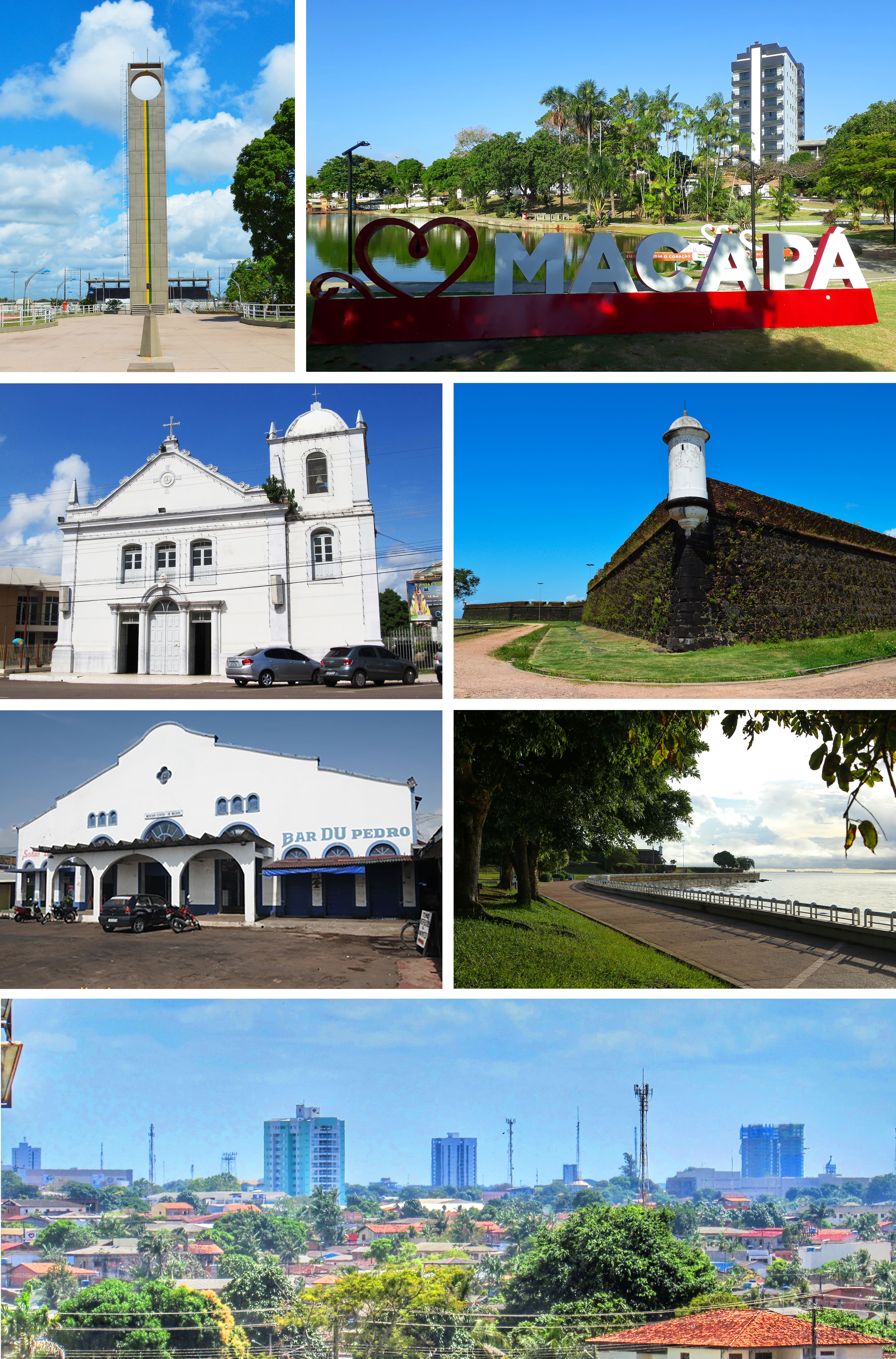
The Marco Zero do Equador is Macapá's most emblematic monument and the reason for its greatest distinction: the city is the only Brazilian capital crossed exactly by the equator, the zero parallel that divides the Earth between the northern and southern hemispheres. The monument, an obelisk surrounded by an esplanade, marks the exact point where that imaginary line passes, and a strip on the ground lets visitors put one foot in each hemisphere at once. The place has an irresistible geographical and symbolic appeal: taking the classic photo 'with one foot in the north and one in the south' is an obligatory ritual. What's more, the monument is designed so that, at the equinoxes (around 20 March and 23 September), the midday sun aligns with the structure in a special way, an astronomical phenomenon tied to its equatorial location. Beside the Marco Zero stands Macapá's Sambódromo and, a short distance away, the famous Zerão stadium. The area is a tourist and leisure spot, with good views and a significance that thrills any traveller curious about geography. Getting there: in the south of the city; by taxi/app or car from the centre. Best time: any day; the equinoxes have a special astronomical appeal. Tips: don't miss the photo straddling the two hemispheres; combine it with a visit to the Zerão stadium, which is nearby; bring sunscreen and water for the equatorial heat.
ℹ️ Distance: South of Macapá (taxi/app or car from the centre) · Best time to go: Any day; the equinoxes have astronomical appeal · Admission: Free (open access to the monument and the esplanade) · Duration: 30 to 60 minutes
2
Estádio Milton Corrêa (Zerão)
The football stadium that's unique in the world, crossed by the equator right through the centre of the pitch.
The Estádio Milton de Sousa Corrêa, popularly known as the 'Zerão', is one of Macapá's most famous curiosities and a one-off in world football. Opened in 1990, the stadium is built in such a way that the equator (the zero parallel, hence the nickname 'Zerão') crosses right through the centre of the pitch, leaving each goal —and each team during the first half— in a different hemisphere: one in the north and the other in the south. That geographical quirk makes the Zerão an unmissable visit for lovers of football and of curiosities. The equatorial line is marked on the pitch, and it's one of the few stadiums on the planet (if not the only one) to offer this. Visiting the stadium to see the equator running through the middle of the field, or catching a match when there is one, is a fun and memorable experience. Worth knowing: in 2026 the Zerão is under revitalization works (Amapá state government), with a complete replacement of the turf and modernization of the structure, drainage and lighting; the work runs through 2026, so check beforehand whether there are matches or visits available, since the sporting calendar may be reduced during the works. The stadium is very close to the Marco Zero, so both attractions —the equator monument and the stadium crossed by the line— are easily visited together, rounding off Macapá's equatorial experience. Getting there: in the south of the city, near the Marco Zero; by taxi/app or car. Best time: any day to see it. Tips: combine it with the Marco Zero, right next door; check on the state of the works and whether there are visits or matches; bring sunscreen and water.
ℹ️ Distance: South of Macapá, near the Marco Zero (taxi/app or car) · Best time to go: Any day; match day for the atmosphere · Admission: Viewing from outside is open and free; match tickets from about R$ 20–60 depending on the game (under revitalization works during 2026: check the calendar; verified July 2026) · Duration: 30 to 60 minutes (plus a match)
3
Fortaleza de São José de Macapá
One of the largest colonial fortresses in Brazil, raised in the 18th century to defend the mouth of the Amazon.
The Fortaleza de São José de Macapá is the city's great historic monument and one of the largest and best-preserved colonial fortresses in all of Brazil. Construction began in 1764 and stretched over decades (completed around 1782) to defend the strategic mouth of the río Amazonas against the claims of the French, English and Dutch, who were contesting control of this rich and coveted region. It's an imposing fortress on a polygonal plan (a four-bastion star shape), with walls, cannons, moats and quarters, raised with materials brought from far away and with the labour of Indigenous and enslaved workers in appalling conditions. Today you can walk it, climb its walls to look out over the río Amazonas and learn its history, which is also the history of how Portuguese and later Brazilian sovereignty was consolidated in the far north of the country. The fortress is the heart of Macapá's historic heritage, the most visited attraction in Amapá, and often a setting for cultural events. Since 2024-2026 it has been undergoing a wide-ranging restoration and modernization project (works in stages, with new food, gallery and signage spaces): it remains open to visitors during the works, but check the opening hours and which areas are accessible before you go. Getting there: in the centre of Macapá, by the river; on foot or by taxi/app. Best time: by day; check the visiting hours. Tips: climb the walls for the view over the Amazon; combine it with the riverfront, which is nearby; bring sunscreen and water for the heat.
ℹ️ Distance: Centre of Macapá, by the río Amazonas (on foot or by taxi) · Best time to go: By day (check the hours) · Admission: Free (open entry to the fortress-museum); open Tuesday to Sunday 8 to 17 h; open during the 2026 restoration works (source: Museu Fortaleza/Secult AP, verified July 2026) · Duration: 1 to 2 hours
4
The riverfront (Orla) and the río Amazonas
The waterfront promenade on the great river, with the pier, the Amazon sunset and Macapá's local life.
Macapá's riverfront (the Orla) is one of the best-loved and liveliest spaces in the city, a promenade on the bank of the colossal río Amazonas, which here, near its mouth, reaches an impressive width. From the promenade you look out over the river, the movement of boats and, above all, the Amazon sunsets, which flood the sky and the water with colour and draw locals and visitors alike. The Orla has walking areas, restaurants, bars and kiosks where you can have a drink, eat fish and enjoy the atmosphere, especially in the afternoons and evenings. It's the ideal place to feel the pulse of Macapá life, beside the river that defines the city's identity. A highlight is the old pier (Trapiche Eliezer Levy), a long walkway that reaches out into the river and offers a unique perspective on the Amazon and on the city. The riverfront connects with the Fortaleza de São José and the historic centre, so it's easy to combine the heritage visit with the riverside walk. It's a good way to close out the day in Macapá, with the river and the sunset in the lead roles. Getting there: in the centre of Macapá, by the river; on foot. Best time: sunset, for the light and the atmosphere. Tips: walk out to the trapiche for the best view; combine it with the fortress; use the kiosks to try the fish; keep an eye on your belongings.
ℹ️ Distance: Centre of Macapá, by the río Amazonas (on foot) · Best time to go: Sunset, for the light and the atmosphere · Admission: Free (open promenade) · Duration: 1 to 2 hours
5
The pororoca (Amazon tidal wave)
The spectacular phenomenon of the tidal wave that runs up the Amazon rivers, tied to the big tides.
The pororoca is one of the most spectacular natural phenomena in the Amazon region and one of the great draws of the state of Amapá. It's a tidal wave that forms when the force of the Atlantic Ocean, on the big tides, runs up the rivers at the mouth of the Amazon against their current, generating waves that can reach several metres in height and advance upriver with a characteristic roar (its name comes from an Indigenous word evoking that noise). The phenomenon happens above all around the full and new moons, when the tides are strongest, and at certain points and rivers in the region. The pororoca became internationally famous because some surfers use it to 'surf' the wave for kilometres, in a one-of-a-kind experience. For visitors, witnessing the pororoca is an impressive display of the force of nature. Seeing the pororoca takes planning: you have to coincide with the right tide dates and travel to the points where it occurs (which can be outside the city), normally on trips or with local guides who know the times and places. Get properly informed before organizing the visit. Getting there: to points around the region depending on the phenomenon, on trips/with guides from Macapá. Best time: around the full and new moons (the big tides); check the calendar. Tips: plan ahead around the tides; hire local guides; bring protection and everything you need, since it's usually in remote areas.
ℹ️ Distance: Points around the mouth of the Amazon (trip from Macapá) · Best time to go: Around the full and new moons (the big tides); check the calendar · Admission: Trip with a local guide; from about R$ 150–400 per person depending on the spot and the logistics (market range, verified July 2026) · Duration: Depends on the trip (can be a full day)
6
Ilha de Santana and the nature around the city
Trips along the river, the nearby Ilha de Santana and the preserved forest of Amapá, one of Brazil's greenest states.
Beyond the centre and its equatorial curiosities, Macapá is the gateway to one of the Brazilian states with the highest proportion of preserved forest: Amapá holds enormous stretches of intact Amazon rainforest and large protected areas. From the city you can arrange boat trips on the río Amazonas and outings into the nature around it. One close and popular destination is the Ilha de Santana, an island and archipelago near the neighbouring city of Santana (the region's port), reachable by boat, with river landscapes, riverside communities and pockets of nature. The river trips let you take in the immensity of the Amazon on its final stretch, before it pours into the Atlantic, and the life of the communities living on its banks. For anyone with more time and an adventurous streak, Amapá offers deep forest areas, national parks and the chance to travel north through the state, as far as the border with French Guiana (Oiapoque), though these trips need more planning and specialist operators. It's a region of nature tourism that's still emerging and very authentic. Getting there: by boat from Macapá/Santana for the Ilha de Santana; organized trips for the more distant nature. Best time: the dry season (July to December) for better conditions. Tips: ask local operators; bring sunscreen, repellent and water; for far-off destinations, arrange things in advance.
ℹ️ Distance: Ilha de Santana near neighbouring Santana (by boat); nature across the state (organized trip) · Best time to go: Dry season (July to December) · Admission: Boat crossing to the Ilha de Santana from about R$ 5–15 per person (local service); organized tourist trips from R$ 100–250 (market range, verified July 2026) · Duration: Half a day to a day or more
Advertisements
What nobody tells you

💵 Prices

Tickets

TypePrice
Marco Zero do EquadorFree (open access)
Estádio Zerão (visit)Viewing from outside is free; match tickets from about R$ 20–60 depending on the game. Under revitalization works during 2026: check the calendar (verified July 2026)
Fortaleza de São José de Macapá (Museu)Free (open entry); open Tuesday to Sunday 8 to 17 h; open during the 2026 restoration works (source: Secult AP, verified July 2026)
Riverfront (Orla) and trapicheFree (open promenade)
Trip to see the pororocaFrom about R$ 150–400 per person with a guide, depending on the spot and the logistics (market range, verified July 2026)
Boat trips / Ilha de SantanaScheduled boat crossing from R$ 5–15 per person; organized tourist trips from R$ 100–250 (market range, verified July 2026)
🔄 updated monthlyOfficial / reference values · double-check when buying

Activities and tours

ActivityPriceDurationOperator
City tour of Macapá (Marco Zero, Zerão, Fortaleza, Orla)About R$ 100–200 per person on a guided half-day tour (market range, verified July 2026)Half a dayLocal agencies and guides
Equatorial photo at the Marco Zero and the ZerãoFree (on your own)1-2 hOn your own
Trip to witness the pororocaFrom about R$ 150–400 per person depending on the spot and the logistics (market range, verified July 2026)Depends on the tides (can be a full day)Specialist guides
Boat trip on the Amazon / Ilha de SantanaScheduled crossing from R$ 5–15; tourist trip from R$ 100–250 per person (market range, verified July 2026)Half a day to a dayBoatmen and local agencies
Nature trip through AmapáFrom about R$ 300–800 per person/day depending on the destination and the operator (market range, verified July 2026)Full day or moreEcotourism operators
🔄 updated monthlyOfficial / reference values · double-check when buying
Advertisements

🚌 How to get there and distances

Getting around

ModePriceDurationNotes
Taxi and apps (Uber, 99)City rides from R$ 7 (minimum fare); short trips R$ 10–20 (market range, verified July 2026)VariableHandy for the airport, the Marco Zero, the Zerão and getting around town. Uber and 99 operate in the city
City busCity fare of R$ 3,70; the intermunicipal Macapá-Santana line about R$ 4 (market range, verified July 2026)VariableA city bus network across town; cheap, but at night a taxi/app is preferable
Boat and river launchLocal crossings (Ilha de Santana) from R$ 5–15; fast launches to Belém from about R$ 200–350 (market range, verified July 2026)VariableEssential for trips on the Amazon, the Ilha de Santana and the river connections (Belém and other points)
MototaxiShort rides from about R$ 8–15 (market range, verified July 2026)VariableCommon in the region for short trips; cheap
Car rentalFrom about R$ 120–200 a day depending on the category (market range, verified July 2026)VariableUseful for getting around the city and out to the surroundings and the north of the state; remember there's no road connection with the rest of Brazil
🔄 updated monthlyOfficial / reference values · double-check when buying

How to get there

RouteAirlines / operatorsAvg. priceDuration
Flight to Macapá (MCP airport) from Belém, Brasília, São PauloLATAM, GOL, AzulR$ 500–1.500 return depending on the origin, the season and how far ahead you book (market range, verified July 2026)Depends on the origin (usually a stopover in Belém)
MCP airport → centre of MacapáTaxis, apps and busesUber/taxi about R$ 20–40; city bus R$ 3,70 (market range, verified July 2026)Around 15 to 25 min
River crossing / connection along the Amazon from BelémAmazon shipping companies (fast launches and hammock boats)Fast launch from about R$ 200–350; hammock boat cheaper (market range, verified July 2026)Several hours to more than a day (boat or fast launch); the port is in neighbouring Santana
By road towards the north of the state / French Guiana border (Oiapoque)Bus companies and private vehiclesMacapá-Oiapoque bus from about R$ 150–250 (market range, verified July 2026)Long distances across Amapá (Macapá has no road connection with the rest of Brazil)
🔄 updated monthlyOfficial / reference values · double-check when buying

🏨 Where to stay

No exact prices: a scale from $ (budget) to $$$$$ (luxury), with 2-3 options per category.

CategoryPriceRecommended options
Better-category hotels / with a river view$$$$$About R$ 280–450 a night (market range, verified July 2026): good-standard hotels in the centre and the riverfront area, some with a view over the río Amazonas (e.g. Hotel Macapaba, Amapá Hotel), practical as a base in the capital
Mid-range hotels in the centre$$$$$About R$ 180–280 a night with breakfast (market range, verified July 2026): a good choice of mid-range hotels in central Macapá, near the fortress, the riverfront and the services
Budget hotels and pousadas$$$$$From about R$ 100–180 a night (market range, verified July 2026): cheap options and pousadas for travellers passing through, backpackers or anyone using the city as a base for exploring Amapá
Places to stay near the airport / the port of Santana$$$$$About R$ 150–280 a night (market range, verified July 2026): practical accommodation for anyone arriving or leaving by air or by river through the port of neighbouring Santana

🍴 Where to eat

TypePriceOptions / signature dish
Amazon river fish and seafood$$$$$Dishes at R$ 40–90 (e.g. filhote à moda da chef about R$ 90; breaded camarão rosa starters about R$ 57), verified July 2026: restaurants serving river fish grilled, fried or in caldeirada (e.g. Restaurante Estaleiro)
Amapaense and Northern regional cooking$$$$$Dishes at R$ 30–70 (market range, verified July 2026): places serving tacacá (tucupi and jambu), maniçoba, savoury açaí (as a side to fish) and farinha
Bars and kiosks on the riverfront$$$$$Portions and dishes at R$ 20–50; beers and drinks from R$ 10 (market range, verified July 2026): bars and kiosks by the river on the Orla for eating fish and watching the sunset over the Amazon
Açaí and Amazon fruits$$$$$A bowl of açaí from R$ 10–25; cupuaçu and fruit juices from R$ 8 (market range, verified July 2026): açaí is the star in Amapá, often eaten as a savoury side to fish
Advertisements

📖 History of Macapá

Origins, formation and what the sources say.

The origin: from the fort of São José de Macapá to the town (1758)

Macapá was born, like so many cities in the Brazilian Amazon, in the shelter of a fortress. In the 18th century, the Portuguese Crown was determined to secure its hold on the northern bank of the mouth of the río Amazonas, a region also coveted by the French, English and Dutch operating out of the Guianas. To fix the border and protect that doorway to the great river, the Portuguese decided to raise a settlement and a large fortress there.

The name 'Macapá' has a Tupi Indigenous root. The most widespread explanation links it to the expression 'macapaba' or 'macapá', which would refer to a place with an abundance of bacabas, an Amazonian palm whose fruit is highly prized: it would mean something like 'place of many bacabas'. Before the Europeans arrived, the region was inhabited by Indigenous peoples, and settlers from the Azores were later added, brought in by the Crown to populate the territory.

The village of São José de Macapá was formally established in 1758. A few years later work began on its great defensive structure, the Fortaleza de São José de Macapá, raised to guard the northern edge of the Amazon estuary. That frontier village, born of military strategy and Amazon geopolitics, would be the seed of today's capital of Amapá.

The Tupi meaning of 'Macapá'
The most accepted etymology derives 'Macapá' from the Tupi 'macapaba' or related expressions, translated as 'place of many bacabas' (an Amazonian palm with edible fruit). As with many Indigenous place names, there are variants in the spelling and in the translation, so it's best taken as an approximation.
Source: https://es.wikipedia.org/wiki/Macap%C3%A1
Founded as a village in 1758
The sources agree that the village of São José de Macapá was established in 1758 as part of Portuguese policy to settle and defend the northern Amazon frontier, with the arrival of Azorean settlers. The great fortress of the same name was built in the following decades.
Source: https://pt.wikipedia.org/wiki/Macap%C3%A1

The Fortaleza de São José: the greatest colonial work in the Amazon

The monument that defines Macapá's historic identity is the Fortaleza de São José de Macapá, considered the largest Portuguese colonial fortification in the whole Amazon and one of the largest in Brazil. Construction began in 1764 and stretched over decades, until it was practically finished around 1782. It was raised with laterite stone, bricks brought as ballast on ships from Portugal, and the labour of Indigenous people, enslaved people and settlers.

The fortress, star-shaped with four bastions and an extensive perimeter of walls, was conceived for heavy artillery and to withstand a possible attack from the river. Its mission was clear: to command access to the northern bank of the mouth of the Amazon and deter any foreign attempt to push into the territory Portugal claimed as its own. Although it never fought any great battles, its mere presence achieved the geopolitical aim of asserting Portuguese sovereignty in the region.

Today the Fortaleza de São José is the city's main historic heritage site and a meeting point for the people of Macapá: a setting for cultural events, festivals and walks, with a view over the river. Visiting its walls and bastions means looking in on the past of a contested frontier, where much of the fate of Brazil's far north was decided.

Construction chronology (1764-1782)
The sources place the start of work on the Fortaleza de São José de Macapá in 1764 and its completion around 1782, with a design attributed to military engineers in the Crown's service. The exact dates of completion vary slightly between sources.
Source: https://pt.wikipedia.org/wiki/Fortaleza_de_S%C3%A3o_Jos%C3%A9_de_Macap%C3%A1

The equator: a city split between two hemispheres

Macapá's great geographical distinction is that the equator —the zero parallel— runs through the city. That makes the capital of Amapá one of the few cities in the world sitting exactly on that imaginary line separating the northern and southern hemispheres, a fact the people of Macapá celebrate as a mark of identity: in Macapá you can, literally, have a foot in each hemisphere.

To mark this point the Marco Zero do Equador was built, a monument with a large obelisk raised on the equatorial line. Next to it stands Macapá's Sambódromo, and a curious detail of the place is that, twice a year, at the equinoxes, the sun aligns in such a way that its rays pass through certain points of the monument, a phenomenon that draws the curious. The Marco Zero is today one of the city's great attractions and an obligatory stop for anyone visiting.

Very close by is another local symbol, the Estádio Milton Corrêa, popularly known as the 'Zerão', the football stadium whose halfway line roughly coincides with the equator: playing there, each team defends a goal in a different hemisphere. That combination of geography and culture gives Macapá a personality unique on the Brazilian map.

Macapá on the zero parallel
The sources agree that the equator passes through Macapá, a fact commemorated by the Marco Zero do Equador. Exactly where the parallel runs in relation to the monument and to the 'Zerão' stadium is approximate, since the line is a geodesic reference.
Source: https://es.wikipedia.org/wiki/Macap%C3%A1

The Franco-Brazilian Contested Territory and the creation of the Territory of Amapá (1900-1943)

Through the 19th century and the early 20th, the Amapá region was the stage for a long border dispute between Brazil and France, which claimed part of that territory as an extension of French Guiana. This was the question of the 'Franco-Brazilian Contested Territory' (or the Amapá question), a strip of forest and rivers whose sovereignty remained undefined for decades and that nearly triggered conflict. The situation worsened with the gold rush in the area of the río Calçoene, which drew prospectors and stoked the tensions.

The dispute was settled diplomatically. In 1900, an international arbitration held in Switzerland —with the award issued by the Swiss Federal Council— found in Brazil's favour and recognized its sovereignty over the disputed territory. A central role in that diplomatic victory was played by the Baron of Rio Branco, the great architect of Brazil's consolidated borders, whose work definitively fixed this far northern edge of the country.

For much of its modern history, the region depended administratively on the state of Pará. That changed in 1943, when the government of Getúlio Vargas, in the middle of a policy of integrating and defending the borders during the Second World War, created the Federal Territory of Amapá, with Macapá as its capital. The city thus became the seat of a new strategic territory in the far north of Brazil.

The 1900 Swiss arbitration award
The Amapá question between Brazil and France was settled by international arbitration with an award by the Swiss Federal Council in 1900, in Brazil's favour. The diplomatic work of the Baron of Rio Branco is widely credited in this outcome.
Source: https://pt.wikipedia.org/wiki/Quest%C3%A3o_do_Amap%C3%A1
Creation of the Federal Territory in 1943
The Federal Territory of Amapá was created by decree of the Getúlio Vargas government in 1943, separating it from the state of Pará, with Macapá as its capital. The sources agree on this framing, tied to the policy of integrating the borders during the Second World War.
Source: https://pt.wikipedia.org/wiki/Amap%C3%A1

From territory to state: Amapá and Macapá as capital (1988)

The decisive step in Macapá's recent political history came with the 1988 Constitution. That new charter, the fruit of Brazil's return to democracy after the military dictatorship, raised the former Federal Territory of Amapá to the status of a state of the federation. Macapá, already the capital of the territory, was confirmed as capital of the brand-new state of Amapá, gaining full political and administrative autonomy.

From then on, Amapá began electing a governor and had its own legislative assembly, and a period of institutional and urban growth began. Macapá established itself as the great centre of services, commerce and administration for a vast state, thinly populated and largely covered by preserved Amazon rainforest —Amapá is one of the states with the highest percentage of protected forest cover in the country.

Today Macapá is a river city that looks out at the great river: its riverfront on the Amazon, with the Fortaleza de São José, the Marco Zero and the piers, condenses its history and its present. A frontier capital, a city on the equator and the doorway to the eastern Amazon, Macapá combines its military and geopolitical past with a present-day role as a base for exploring the nature and culture of Brazil's far north.

Becoming a state under the 1988 Constitution
The sources agree that the 1988 Federal Constitution turned the Federal Territory of Amapá into a state, with Macapá as capital, granting it political autonomy. The state's effective installation and the election of its first authorities took place in the immediately following years.
Source: https://es.wikipedia.org/wiki/Amap%C3%A1

📚 Bibliography

  • Wikipedia (ES) — «Macapá»: https://es.wikipedia.org/wiki/Macap%C3%A1
  • Wikipedia (PT) — «Macapá»: https://pt.wikipedia.org/wiki/Macap%C3%A1
  • Wikipedia (PT) — «Fortaleza de São José de Macapá»: https://pt.wikipedia.org/wiki/Fortaleza_de_S%C3%A3o_Jos%C3%A9_de_Macap%C3%A1
  • Wikipedia (PT) — «Marco Zero do Equador (Macapá)»: https://pt.wikipedia.org/wiki/Marco_Zero_(Macap%C3%A1)
  • Wikipedia (PT) — «Questão do Amapá»: https://pt.wikipedia.org/wiki/Quest%C3%A3o_do_Amap%C3%A1
  • Wikipedia (PT) — «Amapá»: https://pt.wikipedia.org/wiki/Amap%C3%A1
  • Wikipedia (ES) — «Amapá»: https://es.wikipedia.org/wiki/Amap%C3%A1
  • IBGE — «Macapá / Amapá» (histórico): https://cidades.ibge.gov.br/brasil/ap/macapa/historico

❓ Frequently asked questions

What is Macapá famous for?+
For being the only capital in Brazil crossed exactly by the equator. The Marco Zero monument marks where the zero parallel passes, where you can put a foot in each hemisphere, and the 'Zerão' football stadium is built so that the equatorial line crosses the centre of the pitch. On top of that there are the imposing Fortaleza de São José, the río Amazonas and the pororoca phenomenon.
How do you get to Macapá?+
Mainly by plane (MCP airport, usually with a stopover in Belém) or by river along the Amazon, with boat or fast launch connections from Belém (the port is in neighbouring Santana). One important particularity is that Macapá is not connected by road to the rest of Brazil, so plane and boat are the ways in from outside the state.
When is the best time to visit?+
The dry season, roughly July to December, is the best: there's less rain and it's more comfortable to get around the city and its surroundings. The rainy season (January to June) is very intense, since Amapá is one of the rainiest regions in Brazil. The climate is warm and humid all year. To see the pororoca you have to coincide with the big tides (full and new moons).
What is the pororoca?+
It's a spectacular tidal wave that forms when the force of the Atlantic, on the big tides, runs up the rivers at the mouth of the Amazon against their current, generating waves several metres high that advance upriver with a great roar. It happens above all around the full and new moons. Some surfers use it to surf for kilometres. Seeing it means planning the dates and travelling with guides.
How many days do I need in Macapá?+
With 1 to 2 days you'll see the essentials: the Marco Zero, the Zerão stadium, the Fortaleza de São José, the riverfront and the food. With 3 to 4 days you can add river trips, the Ilha de Santana, watching the pororoca (on the right dates) or use the city as a base for exploring Amapá or travelling to the French Guiana border.
What do you eat in Macapá?+
The cooking is Amazonian, with river fish in the lead role (grilled, fried or in caldeirada), often served with açaí in its savoury version (a regional classic, alongside fish and farinha). You can also try tacacá (with tucupi and jambu), maniçoba and Amazon fruits like cupuaçu in juices and desserts. The riverfront kiosks are ideal for trying all of it.
Is it safe to travel to Macapá?+
Macapá is an Amazon capital with the usual dynamics of cities in the region; take the standard precautions: look after your belongings, don't carry much cash in view, avoid quiet areas at night and use a taxi/app to get around. The central and touristy areas by day (Marco Zero, the fortress, the riverfront) are fine to walk with common sense.
Sources consulted (15)
Still planning?
Explore more destinations in Brazil
See all destinations →
Advertisements
Image credits
Photos from Wikimedia Commons, each under its own licence (CC BY, CC BY-SA or public domain). Open each file to see its author and licence.
Macapá Montage (2021)