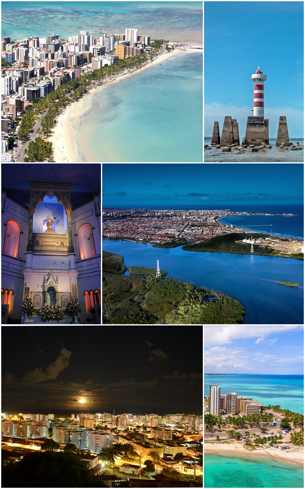
Maceió is the capital of Alagoas and one of the great showcases of Brazil's Northeast: a city with warm weather all year, facing the Atlantic and wedged between the sea and the Mundaú lagoon, famous for the colour of its water — that green-turquoise that earned it the nickname 'Paraíso das Águas' — and for the natural pools that form over its coral reefs. The name comes from the Tupi 'maçayó', read as 'what covers the alagadiço', for the lagoons that abound in the region and that also gave the state its name, Alagoas ('the lagoons').
The tourist heart beats along the orla, a continuous strip of about 6 km linking three city beaches: Pajuçara, Ponta Verde and Jatiúca. Pajuçara is where the jangadas leave for the natural pools offshore and where the craft fair is; Ponta Verde holds the most sought-after address on the strip, with its calçadão of kiosks and restaurants; and Jatiúca adds the nightlife. You can walk all three or drive them in a few minutes, with coconut palms, a bike lane and calm sea in the background.
But what makes Maceió singular is what surrounds it. To the south, the coast holds Praia do Francês and the colonial historic centre of Marechal Deodoro, the dazzling Praia do Gunga with its coloured falésias, and Barra de São Miguel. To the north, Paripueira offers natural pools and a peixe-boi (manatee) sanctuary, and further on come the Rota Ecológica of São Miguel dos Milagres — empty beaches and elegant pousadas — and Maragogi, the famous 'Brazilian Caribbean' of the Galés. Add a history tied to sugar and to the emancipation of Alagoas, a kitchen built on seafood and on sururu, and the filé lacework of Pontal da Barra, and you have a destination that combines beach, nature and culture.
The settlement that gave rise to Maceió grew up around a sugar engenho, in an area of lagoons and coconut palms on the bar of the river that empties into the Atlantic. Its growth was driven by the port of Jaraguá, from which sugar, tobacco, coconut and other goods shipped out. The name, of Tupi origin ('maçayó' / 'maçaio-k'), is usually translated as 'what covers the alagadiço', a reference to the coastal lagoons. Maceió was split off from Vila das Alagoas and raised to a town on 5 December 1815, by alvará of D. João VI. Shortly after, with the political emancipation of Alagoas from Pernambuco in 1817, the process began that would move the provincial capital to Maceió. Finally, by provincial resolution of 9 December 1839, Maceió was raised to a city and made the capital of Alagoas, with the seat of government installed days later. Through the 19th and 20th centuries the city grew as an export port (sugar, cotton, coconut) and an administrative centre, until it reinvented itself in recent decades as one of the great sun-and-beach destinations of the Northeast. In recent years, a ground subsidence process in several neighbourhoods — linked to the mining of rock salt by the company Braskem — affected tens of thousands of people, a painful and still open chapter of its history. The full story is on our history page.
Read the full history ↓The small Northeastern state of lagoons, cane fields and coral reefs: cradle of the Palmares quilombo and of two presidents of Brazil, with the Costa dos Corais and some of the clearest waters and beaches in the country.
Read the history of Alagoas →If you book from here we earn a commission and you pay no more. Prices and availability come from Civitatis.
No exact prices: a scale from $ (budget) to $$$$$ (luxury), with 2-3 options per category.
Origins, formation and what the sources say.
The name Maceió comes from Tupi, the language of the Indigenous peoples who lived along the coast of what is now Brazil's Northeast before the Europeans arrived. The forms recorded by the sources are 'maçayó' or 'maçaio-k', and the most widespread translation is 'what covers the alagadiço' or 'what covers the marsh (or the flooded ground)'. The word referred to the temporary, cyclical lagoons that form at river mouths, where the fresh water meets a sandbar that dams it before it reaches the sea.
That relationship with water is no accident: Maceió is literally wedged between the Atlantic Ocean and the Mundaú lagoon, in a region dotted with lagoons, rivers and mangroves. In fact, the state of Alagoas owes its name to those same lagoons: 'Alagoas' derives from 'as lagoas' (the lagoons), a landscape of water that shapes the whole identity of the region. Capital and state thus share a place-name origin tied to water, which explains Maceió's tourist nickname as the 'Paraíso das Águas'.
Tupi place names are, in this sense, a trace of the peoples who lived on these shores long before the city existed. Although Portuguese colonisation ended up imposing its language, its religion and its sugar economy, the name by which the Alagoas capital is known today is still an Indigenous word that describes its geography precisely: a land where the waters — of the sea, of the rivers and of the lagoons — mix and 'cover' one another.
The settlement that gave rise to Maceió was not a planned foundation with a fortress and a solemn date; it grew slowly around a sugar engenho, in an area of coconut palms and lagoons on the shore of the Atlantic. The sugar economy — the great engine of the colonial Northeast — was the basis of that growth: land, enslaved labour and trade concentrated around the mills, and little by little a cluster of houses appeared that would shape the future city.
Historical sources mention that, as early as the beginning of the 17th century (around 1609), a settler named Manoel Antônio Duro lived in the Pajuçara area, having received a sesmaria (land grant) awarded by Diogo Soares, alcaide-mor of Santa Maria Madalena. These first landholders and their engenhos were the seed of the settlement. But what really drove the town's takeoff was its outlet to the sea.
That outlet was the port of Jaraguá. From its wharf the region's products — sugar, tobacco, coconut and other colonial goods — began to ship out towards other ports in Brazil and overseas. Port traffic drew trade, warehouses, workers and population, and turned that engenho hamlet into an increasingly important point on the coast. The Jaraguá neighbourhood, with its port and its commercial buildings, would remain one of the witnesses to that early prosperity. So while other Northeast capitals were born around forts or precise founding acts, Maceió emerged more modestly, from the combination of a sugar mill and a good natural harbour.
By the early 19th century, the growth of the Maceió settlement — driven by the sugar economy and, above all, by the traffic of the port of Jaraguá — had reached a size that justified administrative recognition. Until then, the settlement depended on Vila das Alagoas (today's Marechal Deodoro), which was the political centre of the region and, in its day, the seat of the fledgling captaincy.
The turning point came on 5 December 1815, when D. João VI — then head of the Kingdom of Portugal, Brazil and the Algarves, installed in Rio de Janeiro after the Portuguese court fled the Napoleonic Wars — signed a royal alvará that split Maceió off from Vila das Alagoas and raised it to the status of vila. With that act, Maceió stopped being a dependent settlement and became an administrative unit in its own right, with its own local government.
The promotion to vila reflected a deeper shift: the region's economic and demographic axis was moving towards Maceió and its port, at the expense of the older, more inland Vila das Alagoas. The port of Jaraguá, growing fast, made the new vila a strategic point for coastal and export trade. That shift of power and wealth towards Maceió would prove decisive a few years later, when it came to deciding which town would be the capital of the new province of Alagoas.
Through the colonial period, the territory of the Alagoas depended on the Captaincy of Pernambuco. That subordination ended in 1817: amid the political conflicts of the time — the Pernambuco region was the stage that year of the Pernambucan Revolution of 1817, an uprising against the crown — the Alagoas won political emancipation from Pernambuco and became a captaincy (later a province) of their own. It was the administrative birth of Alagoas as a separate entity.
With emancipation came an immediate key question: which town would be the capital of the new unit? The traditional seat was Vila das Alagoas (Marechal Deodoro), but economic and demographic weight had swung towards Maceió and its port. The governor of the new captaincy, Sebastião de Melo e Póvoas, began the process of transferring the capital to Maceió, recognising that shift in the region's centre of gravity.
The process concluded in 1839. By a provincial resolution (or law) of 9 December 1839, Maceió was raised to the rank of city and made the seat and capital of the province of Alagoas. A few days later — on 16 December 1839 — the seat of the provincial government was officially installed in Maceió, backed by forces sent in to guarantee order during the move. Maceió has been the capital of Alagoas and the state's political, administrative and port centre ever since.
So in barely two decades, Maceió went from a newly detached vila (1815) to the capital of an emancipated province (1839), consolidating a rise that had been building with the boom in sugar and in the port of Jaraguá.
Once it became the capital, Maceió grew through the 19th and 20th centuries as a port city and the administrative centre of Alagoas. Its historical prosperity rested on port trade and on the state's farm output: sugar from the engenhos, tobacco, coconut, spices and, later, cotton were the great export products passing across its wharves. The Jaraguá neighbourhood, next to the port, held much of that commercial activity, with its mansions, warehouses and buildings from the late 19th and early 20th centuries that still bear witness to that boom.
Economic growth showed in the city. The historic centre saw churches, squares and palaces go up that mark the identity of 'imperial' and republican Maceió: the Metropolitan Cathedral, completed around 1859; Praça dos Martírios (Praça Marechal Floriano Peixoto) with the church of Bom Jesus dos Martírios; and, into the 20th century, the Palácio Floriano Peixoto (1902), seat of the state government for decades and today a museum. These buildings tell the story of a capital moving from sugar town to established city.
The 20th century brought modernisation and urban expansion. Maceió grew outward from the centre and the port towards the beaches, and from the second half of the century sun-and-beach tourism began to reshape the local economy. The beachfront of Pajuçara, Ponta Verde and Jatiúca was built up with coastal avenues, hotels and restaurants, and the city reinvented itself as one of the great destinations of the Northeast, resting on the colour of its sea, its natural pools and its culture. Today Maceió has around a million inhabitants and combines its port and sugar heritage with a clearly tourist vocation, without entirely losing the memory of the economic cycles that made it grow.
Today's Maceió is a tourist capital of nearly a million people, one of the main gateways to beach tourism in the Northeast, with its city beachfront, its natural pools and its southern and northern coastal surroundings. But its recent history is also marked by a dramatic chapter: the afundamento (subsidence) of the ground in several city neighbourhoods, regarded as one of the largest urban socio-environmental disasters in Brazil.
The problem is a process of ground subsidence affecting neighbourhoods such as Pinheiro, Mutange, Bebedouro, Bom Parto and part of Farol. Its cause is attributed to the impact of nearly four decades of rock salt (sal-gema) mining by the company Braskem. Rock salt is a mineral used to make products such as caustic soda and PVC; extraction was carried out through wells that dissolved the salt underground, leaving enormous cavities. Over time, those cavities compromised the stability of the ground and caused cracks, subsidence and deformation in streets, houses and urban infrastructure.
The crisis became clear above all from 2018 on, when cracks and ground movements appeared that led to geological studies and to the conclusion that mining was the cause. It is estimated that tens of thousands of people were affected — residents and shopkeepers — and that thousands of buildings were condemned and left uninhabitable in the compromised neighbourhoods, much of which had to be evacuated and cleared. In December 2023, the collapse of one of the mines (mine 18) made the situation worse. The case led to investigations, reparation and compensation agreements with those affected, and judicial and administrative proceedings against the company.
It's worth pointing out that the tourist area of Maceió — the Pajuçara, Ponta Verde and Jatiúca beachfront — is not affected by this phenomenon, which is concentrated in specific neighbourhoods near downtown and the Mundaú lagoon. But the afundamento became a central issue in the life of the city and an open wound for thousands of families, and it is now part of the contemporary history of the Alagoas capital.