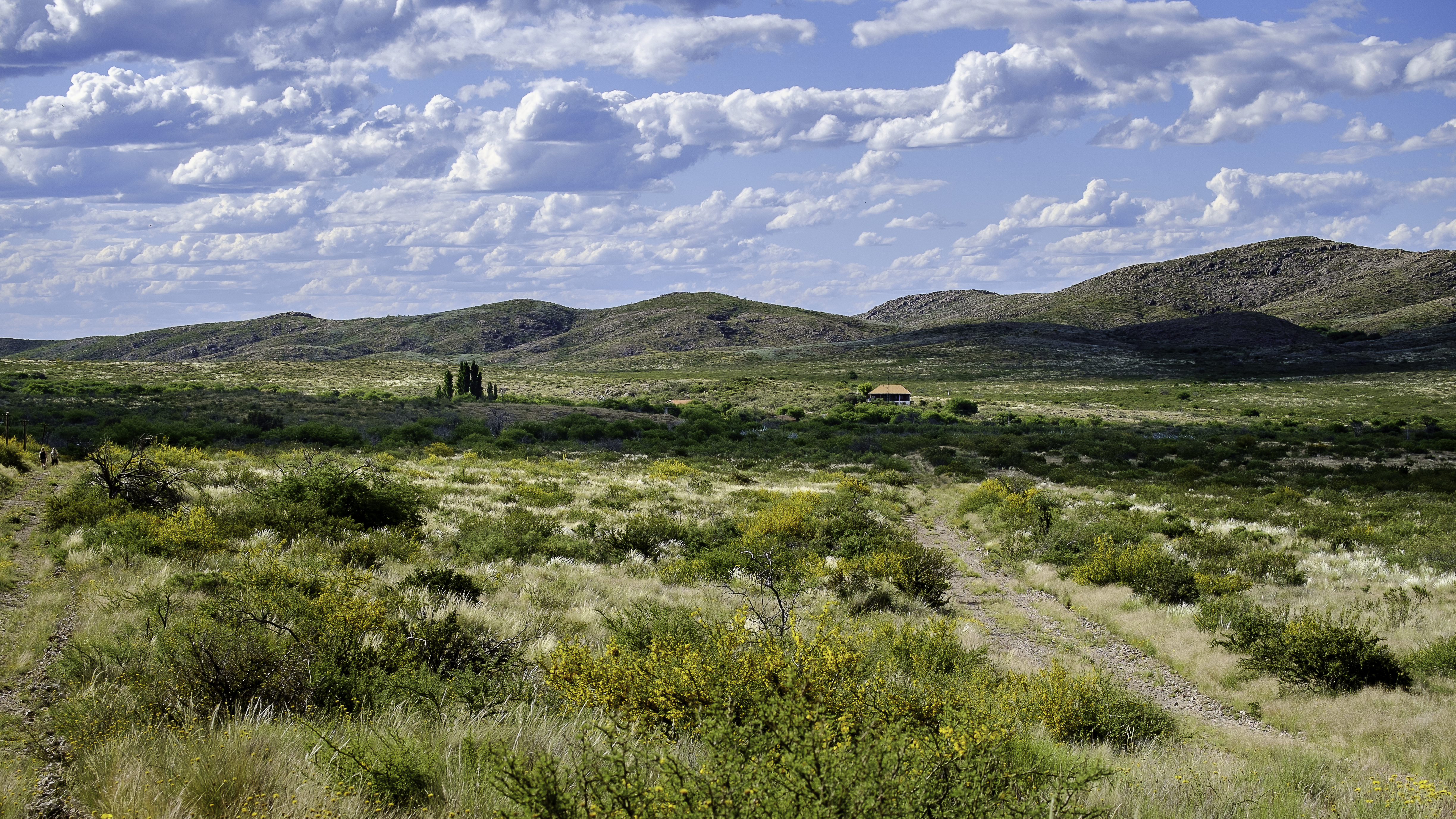
Lihué Calel National Park protects a group of low hills that rise like an oasis of life in the middle of the arid scrubland of southern La Pampa. Its name, of Mapuche origin, is usually translated as 'range of life' (lihué, life; calel, range), and it describes the place perfectly: a hill massif that, thanks to its ability to hold water, concentrates far richer vegetation and wildlife than the surrounding plain.
At around 32,000 hectares, the park combines natural and cultural value. The pink granite hills, the valleys, the wells and the waterholes support endemic flora, guanacos, pumas, maras, vizcachas, foxes and plentiful birdlife. But Lihué Calel is also a site of great archaeological wealth: it preserves rock paintings left by its early inhabitants on overhangs and rock walls, and it was the setting for the history of the Indigenous peoples and of the Conquest of the Desert.
For the traveler, it's a surprising stop on the journey through the arid southern pampas, on the way to Patagonia. Short trails climb to lookouts with panoramic views of the scrubland and the hills, and there's an interpretation centre, a campground and the chance to watch wildlife and see rock art. Lihué Calel shows how, in the middle of aridity, a chain of hills can become a refuge of biodiversity and memory.
The hills of Lihué Calel were inhabited for thousands of years by Indigenous peoples, who left rock paintings on their overhangs (around 1,300 years old). In the 19th century they sheltered the chief Namuncurá during the Conquest of the Desert. The area also protects the remains of the old Santa María de Lihué Calel estancia. It was created as a national park in 1977. The full version is on the history page.
Read the full history ↓The province of the plain and the caldenal: Ranquel land of Mariano Rosas, the last frontier swept away by the Conquest of the Desert, of steppe, salt flats and caldén woodland, between the humid pampa and Patagonia, granted provincehood only in 1951.
Read the history of La Pampa →No exact prices: a scale from $ (budget) to $$$$$ (luxury), with 2-3 options per category.
Origins, formation and what the sources say.
In the middle of the pampas desert, where for kilometres there isn't a single drop of water in sight, there's a handful of pink rocks that for thousands of years decided the difference between life and death. That, at bottom, is what the Lihué Calel hills are: not just another mountain, but the only reliable source of water for hundreds of kilometres around, a fact that explains why whole generations of Indigenous peoples, and later entire armies, fought to control them.
The Lihué Calel hills were, for thousands of years, a point of attraction for the Indigenous peoples of central Argentina. The reason is simple: in the middle of the arid scrubland of the southern pampas, where water is scarce, these granite hills hold moisture, create waterholes and wells, and concentrate vegetation and wildlife. They were, literally, an oasis of life, which is where their Mapuche name comes from, 'range of life'.
That importance as a place of water and shelter was set down in the rock art preserved on overhangs and rock walls, especially in the so-called Valle de las Pinturas. There, early inhabitants left painted motifs that bear witness to their passage and their bond with the place across generations. These paintings are one of the park's main cultural assets.
The groups who lived in and moved through the region belonged to different traditions of hunter-gatherers adapted to the scrubland and steppe environment. The hills worked as a landmark in the landscape, a source of resources and a meeting place, part of networks of movement and resource use that covered wide areas of the pampas and Patagonia.
On 21 March 1884, at the Ñorquín fort, in what is now Neuquén, a man surrendered along with some 240 hungry, unarmed followers, and with him the last great Indigenous resistance on the Argentine pampas was, in practice, extinguished: Manuel Namuncurá, son of the powerful Calfucurá, handed over his weapons to the national troops. A few years earlier, the Lihué Calel hills had been one of his last strongholds.
During the 19th century, the Lihué Calel hills took on a leading role in the conflicts between the Argentine state and the Indigenous peoples of the pampas and Patagonia. The region was under the influence of important chiefs, and the hills, with their water and their shelter, were a strategic site. In the framework of the Conquest of the Desert, the military campaign that in 1879, under General Julio A. Roca, advanced on Indigenous territories, Lihué Calel was a direct setting for the fighting: there Namuncurá tried to regroup his forces against the advance of General Nicolás Levalle's troops, falling back with his family and what was left of his people towards what they called, with every reason, 'the hills of life'.
The resistance lasted a few more years, until Namuncurá's surrender in March 1884 — followed in January 1885 by that of another great chief, Valentín Sayhueque — snuffed out the last hopes of Indigenous autonomy in the pampas-Patagonian region. The outcome of these campaigns meant the definitive incorporation of the region into state control and the opening of the land to settlement. One of Namuncurá's sons, Ceferino, would later be beatified by the Catholic Church, becoming a symbol of the Mapuche-Tehuelche history of southern Argentina. The memory of these events — the long Indigenous presence and its tragic end — is part of the historical account the park interprets today, alongside the natural value of the hills.
After the land was taken over by the state and parcelled out, the hill area became part of cattle ranching operations. In particular, the hills and their surroundings formed part of the Santa María de Lihuel Calel estancia, a rural operation whose main buildings still leave remains inside the present-day park, a testimony to the era when the place was used for farming.
As the 20th century went on, recognition of the natural and cultural value of the hills — their oasis biodiversity, their endemic flora, their wildlife and their rock art — drove a push for protection. So, in 1977, Lihué Calel National Park was created, with the aim of conserving this unique hill enclave in the middle of the pampas scrubland.
Since then, the National Parks Administration has managed the area's more than 32,000 hectares, regulating public use, the trails and the conservation of the archaeological sites. Today the park combines protection of nature with the presentation of the site's history, offering the visitor a summary of the landscape, the wildlife and the memory of the southern region of La Pampa.
The secret of Lihué Calel is its geology. The hills, made of ancient rock of volcanic and granitic origin in pink tones, rise only a few hundred metres above the plain, but that difference is enough to change everything. The rock captures and holds the water of the scarce rains, feeding waterholes, wells and seasonal streams that create a more humid microclimate. That's why, while arid scrubland stretches away all around, denser and more diverse vegetation thrives in the hills.
That oasis effect explains the park's biological richness: flora with endemic species and adaptations to aridity, and wildlife that includes guanacos, maras, vizcachas, pumas, foxes and plentiful birdlife. After the rains, the scrubland bursts into flower and carpets the slopes with colour, one of the sights visitors most look for. In that sense, Lihué Calel is a natural laboratory of how geology shapes life.
Conserving this enclave faces the challenges typical of a fragile, semi-arid environment: pressure from livestock and invasive species in the surrounding area, fire risk, drought and climate change, and the need to protect the archaeological sites from deterioration and vandalism. The park's management combines scientific research, environmental education and low-impact tourism, with the aim of preserving both the oasis of biodiversity and the age-old memory these hills of life hold.