Viajá con Gus
Home › Togo › Koutammakou (Tamberma country)
Koutammakou (Tamberma country)
🇹🇬 Togo · Kara Region

Koutammakou (Tamberma country)

🪪 What do I need to enter Togo?Pick your citizenship and we tell you the visa, the days and the paperwork, with the official source.

By leaving your email and citizenship you agree to receive the documents you asked for and weekly travel news. You can unsubscribe whenever you want. How we handle your data.
Jump to what you need
📍Region
Koutammakou is a cultural landscape in north-eastern Togo, in the Kara Region, on the border with Benin (the site continues into Benin's Atakora department). It is the homeland of the Batammariba people (called Tamberma by the colonial administration), famous for their tatas or takienta: multi-storey fortress-houses of mud and straw, unique in the world. It is Togo's only World Heritage Site (UNESCO, 2004, extended in 2023). Nadoba, with its market, is one of the access points.
📌UNESCO recognition
Inscribed on the UNESCO World Heritage List in 2004 (with a 2023 extension that added the Beninese part), under cultural criteria. The site covers about 50.000 hectares in Togo (and more than 270.000 with the cross-border extension), and is recognised as a living cultural landscape, where traditional architecture and the bond with nature are still very much alive.
📌Best time to go
The dry season, from November to February, is the best time to visit (from December to March the harmattan brings dust). Walks between villages are more comfortable and the tracks are firm. In the rainy season (May–October), the landscape is green and the tatas look splendid, but rural access can get difficult. Market days (as in Nadoba) are a good time to see local life.
📌Suggested days
The typical visit lasts from half a day to a full day, leaving from Kara (1,5–2 hours away). With a guide you visit several tata villages, go inside a house and learn about Batammariba culture. If you want to go deeper, you can spend the night at an eco-lodge in the area or time your visit with a market day.
📌Getting there
Koutammakou is visited from Kara, the nearest large town. You get there by car with a driver along the road to Kandé and then on to the villages (Nadoba, Warengo, Koutougou and others), scattered across the landscape. Going with a local guide is essential: the villages are an inhabited area, not a museum, and the guide arranges the visits, the contributions to families and respect for local customs.
📌Currency
The currency is the West African CFA franc (XOF); in 2026 it is around ~600 FCFA to the dollar (655,957 to the euro, fixed rate). There are no ATMs or card payments in Koutammakou: bring cash in francs for access, the guide, house visits and craft purchases.
💱 XOF exchange rate
Loading rate…
🌤️ Weather in Koutammakou (Tamberma country)
Loading weather…

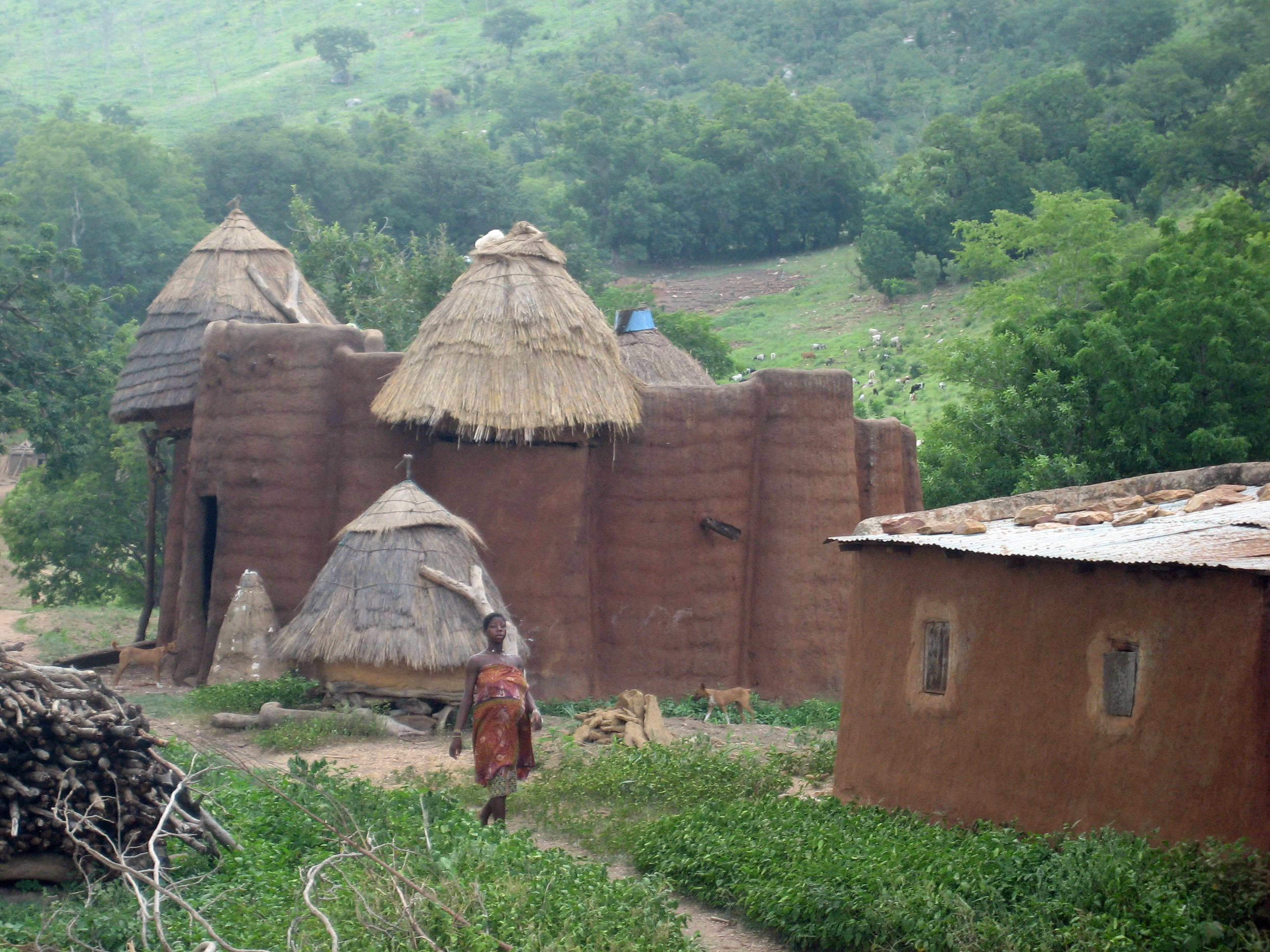
Koutammakou, the land of the Batammariba, is Togo's cultural gem and its only World Heritage Site. In this north-eastern landscape, on the border with Benin, the Batammariba people have been building their tatas or takienta for centuries: extraordinary two-storey fortress-houses of mud and straw, with towers, conical granaries and terraces, true 'earth castles' that serve at once as home, granary, animal pen and temple, and that express a whole worldview.

It is neither a museum nor a stage set: Koutammakou is a living cultural landscape, where thousands of people still live in their tatas, farm the land, revere their sacred forests and rocks and pass their culture on from generation to generation. Exploring it with a Batammariba guide, stepping inside a tata, climbing up to its terrace and hearing the meaning of every corner of the house is one of the most striking experiences West Africa has to offer.

This guide explains how to plan your visit: how to get there from Kara, which villages to visit, how much access and the guide cost, how to behave in an inhabited area, when the markets are held and the best time to go. A destination that calls for respect and sensitivity, and rewards you with an encounter with one of the most singular and best-preserved traditional cultures and architectures on the planet.

📖 History of Koutammakou (Tamberma country)

Koutammakou is the homeland of the Batammariba (Tamberma) people, who settled in these lands of north-eastern Togo in the 17th and 18th centuries, fleeing wars, centralised powers and the slave trade. In their scattered villages they built the tatas or takienta, multi-storey fortress-houses of mud and straw, designed for defence, family life and the expression of their animist beliefs. This cultural landscape, where an agricultural society lives in harmony with nature (with sacred forests and rocks), was inscribed by UNESCO in 2004 as a World Heritage Site, Togo's only one, and extended in 2023 with its Beninese part. Today the tata is a national symbol of the country.

Read the full history ↓

🏛️ Koutammakou (Tamberma country) is in Kara Region

Land of the Kabye people and cradle of Togolese military power: Eyadéma was born here, the Evala wrestling is held here, and here stands Koutammakou, the Batammariba mud castles, a World Heritage Site.

Read the history of Kara Region →

🗺️ What to see

1
The tatas (takienta): mud fortress-houses
The main draw: two-storey homes of mud and straw, with towers, conical granaries and terraces, combining domestic, defensive, storage and religious functions. Unique in the world and a national symbol of Togo.
2
Visiting the inside of a tata
With permission and a guide, you enter an inhabited house: the ground floor for animals and cooking, the upper terrace for sleeping and drying grain, the granaries, the altars. A living lesson in architecture and worldview.
3
The Batammariba cultural landscape
Scattered villages among fields of millet, sorghum and yam, sacred forests, revered rocks and hills; a landscape where architecture, farming and religion form a harmonious whole.
4
Nadoba market
One of the access points and a hub of local life: on market days the village fills with people, produce, millet beer (tchouk) and atmosphere, ideal for getting a close look at Batammariba society.
5
Rites, altars and sacred forests
Batammariba culture is deeply animist; the altars in front of the houses, the fetishes, the sacred rocks and forests are part of a spiritual universe that the guide explains with respect.
6
Walks between villages
Walking the paths between tatas and fields lets you take in the landscape, daily life and the Batammariba's relationship with their surroundings, in an area that still sees very few tourists.
7
Batammariba crafts
Pottery, basketry, ritual objects and textiles made by the communities; buying them directly from families is a way to support the local economy.
📶I have never landed without internet. I arrive and my phone connects to the strongest network in the country I am visiting: I can say I landed, sort out transport, book tours and keep posting, at a seriously good price. I always use the Maya eSIM — check their plans by clicking the banner.See plans →Maya Mobile eSIM — skip roaming fees, unlimited data
What nobody tells you

💵 Prices

Tickets

TypePrice
Acceso al sitio / tasa de aldeaAccess contributions of ~1.000–3.000 FCFA per person depending on the village (~US$ 2–5; check when visiting, 2026)
Guía local obligatorioAbout 5.000–15.000 FCFA per group/day (~US$ 8–25, 2026)
Visita al interior de una tata (aporte a la familia)About 1.000–3.000 FCFA per house (~US$ 2–5, 2026)
Permiso de fotografía / cámaraToken contributions depending on the case; always ask permission before photographing people (2026)
🔄 updated monthlyOfficial / reference values · double-check when buying

Activities and tours

ActivityPriceDurationOperator
Guided tour of the tata villagesWith a guide from ~10.000–25.000 FCFA per group + village contributions (US$ 17–42, 2026)Half day to full dayLocal Batammariba guides
Day trip from Kara (with transport)From ~25.000–60.000 FCFA per person/group with car, driver and guide (US$ 42–100, 2026)Full dayAgencies / car with driver from Kara
Visit inside a tata with explanationContribution ~1.000–3.000 FCFA per house (US$ 2–5, 2026)30–60 minBatammariba families
Walk between villages and sacred forestsIncluded with the guide (~extra contribution to be agreed, 2026)2 to 4 hoursLocal guides
🔄 updated monthlyOfficial / reference values · double-check when buying

🚌 How to get there and distances

Getting around

Car with driver / private taxi from Kara
PriceFull day from ~25.000–45.000 FCFA (~US$ 42–75, 2026)
Duration1,5–2 h to the villages + tour
Notes
The best and almost the only practical option: the villages are scattered and public transport barely reaches them. Combine it with the guide
Motorbike taxi (zémidjan)
PriceLocal rides by arrangement (~1.000–3.000 FCFA, 2026)
DurationVariable
Notes
Useful for short stretches within the area; impractical for visiting several scattered villages
Shared taxi to Kandé
PriceKara–Kandé from ~1.500–3.000 FCFA (~US$ 2,5–5, 2026)
Duration1–1,5 h
Notes
Kandé is the reference town on the route; from there you arrange access to the villages with a guide and local transport
🔄 updated monthlyOfficial / reference values · double-check when buying

How to get there

RouteAirlines / operatorsAvg. priceDuration
Kara → Kandé → Koutammakou villages (Nadoba, Warengo…)Car with driver / taxiDepending on the arrangement (~25.000–45.000 FCFA for the car, return trip for the day, 2026)1,5 to 2 h + tour
Lomé → Kara → KoutammakouBus to Kara + day tripLomé–Kara ~7.000–12.000 FCFA + day trip (~US$ 12–20 for the bus, 2026)7–9 h to Kara + 1 day trip
From Benin (Atakora): the site continues into Beninese territoryCross-border transport / operatorsDepending on the route; requires entry through an authorised border post (2026)Variable
🔄 updated monthlyOfficial / reference values · double-check when buying

🏨 Where to stay

No exact prices: a scale from $ (budget) to $$$$$ (luxury), with 2-3 options per category.

Base in Kara (mid-range to upper)
Price$$$$$
Recommended options
About 15.000–55.000 FCFA per night (US$ 25–90); most people sleep in Kara, which has good hotels, and do Koutammakou as a day trip
Accommodation in Kandé
Price$$$$$
Recommended options
About 8.000–18.000 FCFA (US$ 13–30); simple auberges in the route's reference town, to be closer to the villages
Eco-lodge / community camp
Price$$$$$
Recommended options
Contribution to be agreed (~8.000–20.000 FCFA); small ecotourism projects near the site that let you stay overnight and experience the area more closely
Batammariba homestay (subject to availability)
Price$$$$$
Recommended options
Contribution to be agreed with the community; an immersive experience sleeping among the tatas, arranged by local guides and projects

🍴 Where to eat

Comida local batammariba y del norte
Price$$$$$
Options / signature dish
Contributions to be agreed (~1.000–3.000 FCFA); millet or sorghum pâte with sauces, yam, and the area's typical millet beer (tchouk or tchoukoutou)
Maquis y restaurantes en Kara / Kandé
Price$$$$$
Options / signature dish
About 1.500–4.000 FCFA per person (US$ 2,5–7); the best places to eat are in Kara and Kandé, not inside the site
Provisiones para la excursión
Price$$$$$
Options / signature dish
From ~1.000 FCFA; bring plenty of water, fruit and snacks from Kara, as there are almost no services in the villages

📖 History of Koutammakou (Tamberma country)

Origins, formation and what the sources say.

The Batammariba: 'those who shape the earth'

Koutammakou is the land of the Batammariba people, whose name is usually translated as 'those who shape the earth' or 'the good builders in earth', a reference to their extraordinary mud architecture. The colonial administration called them 'Tamberma', a name they are also known by, but they call themselves Batammariba and their land Koutammakou. They live in north-eastern Togo and, across the border, in north-western Benin, in a landscape of savannah, hills and cereal fields.

According to tradition and research, the Batammariba settled in this region during the 17th and 18th centuries, amid the great upheavals that shook West Africa at the time. They migrated from the north and north-west, fleeing conflict, domination by centralised powers and, above all, the slave trade that was ravaging the region. They were looking for a refuge where they could live free and protected, and they found it in these somewhat remote lands, where they built an egalitarian society with no centralised state or powerful chiefs, organised around the family, the village and religion.

That history of flight and the search for refuge explains many features of their culture, starting with their defensive architecture. The Batammariba built a civilisation based on self-reliance, subsistence farming (millet, sorghum, yam, fonio) and a deep animist spirituality that runs through every part of their lives, from building their houses to tending their fields and dealing with the ancestors and the forces of nature.

The tata: architecture, defence and worldview

The symbol of Koutammakou and of its whole culture is the tata, or takienta: the traditional Batammariba house and one of the most original vernacular architectures in the world. It is built from mud (kneaded earth) and wood, topped with straw, and usually has two storeys. The ground floor, cool and almost windowless, holds the kitchen, a space for livestock and storage; an inside ladder (often a carved tree trunk) leads up to the roof terrace, where people sleep in the cool night air, dry grain and do household chores. Around and on top of the house stand the cylindrical granaries with conical straw roofs, where the harvest is stored.

The tata was originally designed as a fortified house. At a time of wars and slave raids, its design offered protection: thick walls, few and small openings, a single low, narrow entrance that was easy to defend, and a raised terrace from which to keep watch and hold out. That defensive role, now long gone, left its mark on an architectural form that combines beauty, ingenuity and practicality, perfectly suited to the local climate and materials.

But the tata is much more than a clever dwelling: it is the physical expression of a whole worldview. Every part of the house has a symbolic and religious meaning; building it follows ritual rules, and the house holds altars and fetishes that link it to the ancestors and the deities. The tata is at once body, temple, granary and fortress, a microcosm that reflects the Batammariba way of understanding the world, the family and the sacred. Because of its unique value, the tata became Togo's national symbol and appears as an emblem of the country.

A living cultural landscape: nature and spirit

What UNESCO recognised in Koutammakou was not just a group of remarkable houses but a living cultural landscape: a territory where Batammariba society keeps up a deep, harmonious relationship with the nature around it. The tatas are scattered among fields of millet, sorghum and yam, hills and rocky outcrops, and the whole landscape is charged with spiritual meaning. There is no separation between the human world and the natural one: together they form a single whole.

That harmony shows in the many sacred features of the landscape. There are sacred groves that are never cut, revered rocks and springs, open-air altars, and places linked to the ancestors and the deities. Farming, hunting, building and rites of passage (birth, initiation, marriage, death) follow religious calendars and rules handed down orally from generation to generation. Batammariba culture is, to a large extent, intangible heritage: knowledge, music, dances, oral traditions, building and healing techniques.

That living character is both Koutammakou's greatest wealth and its greatest fragility. Unlike a stone monument, a living cultural landscape depends on people continuing to live in it and practise their culture. That is why, after the inscription, UNESCO launched a safeguarding programme in 2008 focused on passing knowledge and techniques from one generation to the next (building tatas, traditional medicine, music, dance, oral traditions), aware that without that transmission the landscape would lose its soul.

World Heritage: Togo's only site

In 2004, UNESCO inscribed Koutammakou, the Land of the Batammariba, on the World Heritage List under cultural criteria, as an outstanding example of a traditional human settlement representing a culture that is still alive. It thus became Togo's only World Heritage Site, a major international recognition for the country and for a culture that until then was little known outside the region. The inscription covered some 50,000 hectares of Togolese territory.

In 2023, the site was extended to include the Beninese part of the Batammariba landscape, in the Atakora department, recognising that this people's culture and territory stretch across both sides of the border. With that cross-border extension, the property grew to more than 270,000 hectares between Togo and Benin, becoming an example of heritage shared by two countries around a single living culture.

UNESCO recognition brought prestige and visibility, but also responsibilities and challenges. Koutammakou faces the pressures of modern life (the temptation to abandon tatas for concrete buildings, young people moving away, economic change) and specific events such as the damage caused by exceptional rains (for example in 2018, which prompted an emergency UNESCO mission). Preserving this heritage means balancing respect for the Batammariba's way of life and choices with support so that their culture and architecture stay alive.

Visiting Koutammakou today: respect and encounter

Today, Koutammakou is Togo's great cultural destination and one of the most memorable visits in West Africa. It is explored from Kara, the nearest large town, on a day trip with a car, driver and guide, visiting several tata villages (Nadoba, Warengo, Koutougou and others), going inside a house with permission, climbing up to its terraces and learning, from Batammariba guides, the meaning of each element of the architecture and of daily life.

The key to the visit is respect. Koutammakou is not a stage set or an open-air museum: it is a lived-in territory, where families live, work and practise their religion. Travellers should behave as guests: ask permission before entering houses and before photographing people, leave a contribution for the families, buy crafts directly from the communities and follow the guide's directions about sacred places. That respect is what makes the visit a genuine encounter rather than an intrusion.

Exploring Koutammakou is a glimpse into a way of life and an architecture that have survived for centuries, a culture that made the earth its home, its temple and its fortress. Among the millet fields, under the skies of northern Togo, the mud castles of the Batammariba still stand as a testament to a free, ingenious and deeply spiritual civilisation. It is, rightly, Togo's greatest treasure and a heritage of all humanity.

📚 Bibliography

  • UNESCO — «Koutammakou, the Land of the Batammariba»: https://whc.unesco.org/en/list/1140/
  • Wikipedia (EN) — «Koutammakou»: https://en.wikipedia.org/wiki/Koutammakou
  • Wikipedia (FR) — «Koutammakou»: https://fr.wikipedia.org/wiki/Koutammakou
  • World Heritage Site — «Koutammakou»: https://www.worldheritagesite.org/list/id/1140
  • Kanaga Africa Tours — «The Tamberma's straw and mud tatas»: https://www.kanaga-at.com/en/trip-info/togo-en/the-tambermas-straw-and-mud-tatas/
  • Qiraat Africa — «Koutammakou, the Land of the Batammariba, Togo»: https://qiraatafrican.com/en/17919/koutammakou-the-land-of-the-batammariba-togo/
  • Afrique Destinations — «Koutammakou: in the land of the Batammariba or Tamberma»: https://www.afriquedestinations.com/en/tourismbenin-togo-koutammakou-land-batammariba-or-tamberma
  • Wikipedia (EN) — «Tammari people»: https://en.wikipedia.org/wiki/Tammari_people
  • UNESCO — Programme de sauvegarde de Koutammakou (2008): https://whc.unesco.org/en/list/1140/documents/
  • Voyage-Togo — «Kara, guide complet (Koutammakou, Evala, Mont Kabyè)»: https://www.voyage-togo.com/guide-togo/destination/kara

❓ Frequently asked questions

What is a tata (takienta) and why is it so special?+
The tata or takienta is the traditional house of the Batammariba: a two-storey mud and straw building with towers, conical granaries with thatched roofs and an upper terrace. It is not just a home: it combines domestic functions (kitchen, bedrooms), shelter for animals, grain storage and religious functions (altars, fetishes). Its originally defensive design and deep symbolism make it a work unique in the world. The tata is also Togo's national symbol, and the landscape as a whole was declared a World Heritage Site by UNESCO in 2004.
Is Koutammakou a museum, or do people really live there?+
It is a living cultural landscape, not a museum or a theme park: thousands of Batammariba live in their tatas, farm the land and practise their culture and animist religion every day. That is why the visit calls for respect: you are entering inhabited houses and villages, always with a local guide, asking permission to go in and take photos, and leaving a contribution for the families. Behaving as you would in someone's home, not on a stage set, is essential.
Do I need a guide, and how do I find one?+
Yes, a local guide is essential. The villages are scattered across the landscape, there are no signs, and only a Batammariba guide can arrange house visits, contributions to families, explanations of the culture and respect for customs and sacred places. The usual approach is to book a day package in Kara with car, driver and guide, or to go to Kandé and arrange access there with a guide and local transport.
How much does it cost to visit Koutammakou?+
The main costs are transport from Kara (car with driver, ~25.000–45.000 FCFA for the day), the guide (~5.000–15.000 FCFA) and access contributions for the villages and the families whose tatas you visit (~1.000–3.000 FCFA each). Overall it is an affordable trip; bring enough cash in CFA francs, as there are no ATMs or card payments, and leaving tips and buying crafts helps the local economy.
When should I go and what should I bring?+
The dry season (November–February) is best for the tracks and walks; the rainy season leaves the landscape green but can make access difficult. Timing your visit with a market day (such as Nadoba's) lets you see local life at its liveliest. Bring comfortable shoes, plenty of water, a cap, sunscreen, cash in francs and, above all, a respectful attitude: always ask permission before photographing people.

More places in Togo

KpaliméLago TogoLoméMercado de Fetiches de AkodessewaMonte KlotoPico de Agou (Monte Agou)
See every place in Togo →The history of Togo →
Sources consulted (6)
Still planning?
Explore more destinations in Togo
See all destinations →
Image credits
Photos from Wikimedia Commons, each under its own licence (CC BY, CC BY-SA or public domain). Open each file to see its author and licence.
Togo Taberma house 02