Viajá con Gus
Home › Central African Republic › Bouar
Bouar
🇨🇫 Central African Republic · The west: plateaus and megaliths

Bouar

🪪 What do I need to enter Central African Republic?Pick your citizenship and we tell you the visa, the days and the paperwork, with the official source.

By leaving your email and citizenship you agree to receive the documents you asked for and weekly travel news. You can unsubscribe whenever you want. How we handle your data.
Jump to what you need
📌Safety warning — read first
The United States Department of State keeps the Central African Republic at Level 4, “Do Not Travel”, due to violent crime, kidnapping, landmines, terrorism and civil unrest; the current advisory is dated 15 January 2026. Spain's Ministry of Foreign Affairs is even more categorical: «se desaconseja el viaje bajo cualquier circunstancia y se recomienda a los españoles que se encuentren en el país que lo abandonen lo antes posible» (travel is advised against under any circumstances, and Spaniards in the country are advised to leave as soon as possible; MAEC travel advice, last updated 22 May 2024). It specifically names the Bangui–Garoua-Boulaï road as especially dangerous, and that is exactly the route Bouar sits on. This page is an informational and heritage guide, not an invitation to travel.
📌Location
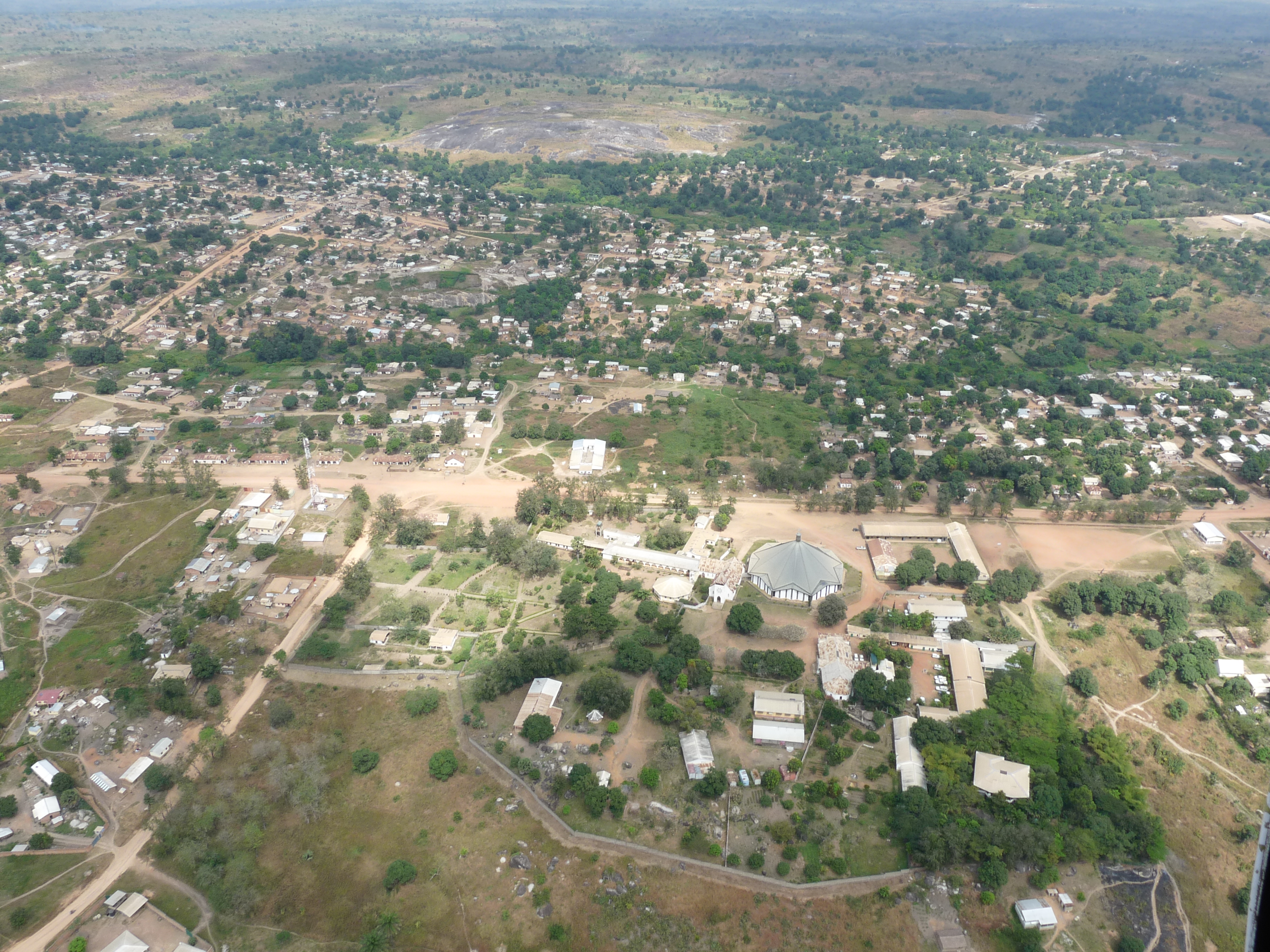
Bouar is the capital of the Nana-Mambéré prefecture, in the west of the Central African Republic, some 450 kilometres by road from Bangui and just over 200 from the border with Cameroon. It sits on the Yadé granite massif, at an altitude of 1,046 metres, one of the highest plateaus in the country.
📌Why it matters
The area around Bouar holds the largest concentration of megalithic monuments in Central Africa: the tazunu, mounds topped with large standing granite blocks. There are dozens of groups of them across an area of roughly 130 by 30 kilometres. UNESCO added them to its World Heritage Tentative List on 11 April 2006, in the cultural category, under the name «Les mégalithes de Bouar».
📌Population
About 39,205 inhabitants according to the 2012 estimate, and around 40,353 in the 2003 census. It is one of the largest towns in the country's interior, with 48 registered neighbourhoods, a court of appeal and the seat of the Catholic Diocese of Bouar, created in 1978.
📅Climate
Tropical savanna climate (Köppen Aw), but much milder thanks to the altitude: it is one of the coolest places in the country. Annual rainfall is around 1,462 mm, concentrated between May and October. The dry season, from December to March, is the only window when the dirt tracks in the area are passable.
📌Language and currency
French and Sango are the two official languages. In the Bouar region most people speak Gbaya, and the word tazunu, meaning “standing stone”, comes from Gbaya-Kara. The currency is the Central African CFA franc (XAF/FCFA), pegged to the euro: 1 EUR = 655.957 FCFA. It is a cash economy, with practically no ATMs or card payments outside Bangui.
📌Getting there (in theory)
Bouar is on the Route Nationale 3, the only paved corridor linking Bangui with the Cameroonian port of Douala. The stretch from Bouar to the border was paved around 2013, and the last unfinished section, Baoro–Bouar, was completed in 2020. Even so, the roughly 1,500-kilometre Douala–Bangui journey takes five to seven days because of the many checkpoints and weighbridges, and official travel advice specifically warns against using this road. There is a local airfield but no regular commercial flights. Air traffic in the interior is limited to humanitarian operations (UNHAS) open only to accredited personnel.
📌Entering the country
You need a passport valid for at least six months, a visa obtained in advance (they are not issued on arrival) and an international certificate of vaccination against yellow fever, which is mandatory for all travellers aged 9 months and over. Antimalarial prophylaxis is also recommended, along with vaccines against tetanus, hepatitis A and B, typhoid and meningitis.
📌Tourist services
There are no verifiable tourist services operating in Bouar: no hotels with published rates, no agencies, no guides to the megalithic sites and no official admission to the tazunu. Any figure you find online for accommodation or excursions in this area should be treated as unverified. What does exist, and is documented, is the heritage.
💱 XAF exchange rate
Loading rate…
🌤️ Weather in Bouar
Loading weather…

In heritage terms, Bouar is one of the most important places in Central Africa, and yet almost nobody has heard of it. On the granite plateaus of the Yadé massif, a thousand metres up, there are dozens of groups of huge stones standing on earth mounds: the tazunu. They were raised by farming and metalworking communities about two and a half thousand years ago, and they form the most important megalithic complex in the whole of equatorial Africa.

The town itself is a prefecture capital of some forty thousand people, with a market, a cathedral, a court and an unusual colonial history. It was French from 1894, German from 1911 to 1914 under the territorial exchange in the Morocco–Congo Treaty, French again after the First World War, and home to the French military base Camp Leclerc until December 1997. It lies on the Route Nationale 3, the artery that connects this landlocked country with the port of Douala.

This guide is informational and deliberately honest. The Central African Republic has been caught up in armed conflict since 2013, and the official travel advice from the United States and Spain advises against any travel to the country. You won't find hotel or excursion prices here, because there are no verifiable tourist services operating in Bouar. What you will find is what is documented: what the tazunu are, what is known about who built them, and why this corner of the plateau deserves a place on any map of African heritage.

📖 History of Bouar

People have lived around Bouar for a very long time. In the first millennium BC, local communities built the tazunu: artificial mounds topped with large standing granite blocks, gathered into about seventy groups across a strip of land some 130 by 30 kilometres. The modern town dates from around 1840, when the Gbaya chief Bogbafeï settled there; its name comes from the Gbaya word for “bean”. France took control in 1894, Germany briefly ran it from 1911 to 1914 as part of Neukamerun, and France took it back after the First World War. Electricity arrived in 1952, the Catholic Diocese of Bouar was created in 1978, and Camp Leclerc, a French army base, operated there until December 1997. Between 2013 and 2021, during the Central African civil war, control of the town passed several times between armed groups and government forces.

Read the full history ↓

🏛️ Bouar is in the west: plateaus and megaliths

The western plateaus hold the tazunu of Bouar, the oldest megaliths in Central Africa. They were also the centre of the Kongo-Wara rebellion and of the country's diamond lands.

Read the history of The west: plateaus and megaliths →

🗺️ What to see

1
The tazunu of Bouar (megalithic complex)
The greatest heritage site in the region and in Central Africa: around seventy groups of megalithic monuments spread over an area of roughly 130 by 30 kilometres, covering some 7,500 km² in total. Each tazunu is an earth mound built up by hand, with granite blocks set into it. The stones range from under a metre to over five metres tall, and from a few hundred kilos to about thirty tonnes. They have been on the UNESCO World Heritage Tentative List since 11 April 2006.
2
Tazunu Beforo
One of the seven monuments excavated by the French anthropologist Pierre Vidal in the digs that began in 1961, and the site that gave its name to one of the architectural types later researchers identified. Beforo-type tazunu have a concentric layout, with stone niches or chambers around the edge of the mound.
3
Tazunu of Tia (Tia 1, Tia 2 and Tia 3)
A group of three monuments excavated by Vidal, each of which gives its name to a different architectural variant in the tazunu typology. They show most clearly that this is not one model repeated over and over, but a building tradition that changed over time.
4
Tazunu Gam, Zupaya and Be Yolé
The other three sites in Pierre Vidal's first round of excavations, alongside Beforo and the three at Tia. Together they defined the seven reference architectural types used to classify Central African megaliths: Beforo, Gam, Tia 1, Tia 2, Tia 3, Zupaya and Be Yolé.
5
Ndio megalithic area (Balimbé and Bétumé)
In 1975 and 1976, archaeologist Nicholas David of the University of Calgary excavated the Balimbé 1 and Bétumé tazunu in the Ndio area. His work provided some of the radiocarbon dates that place the construction of these monuments in the first millennium BC.
6
The tazunu of Narèmè
The megalithic groups near the village of Narèmè are the ones the Central African application highlighted when it put the site forward to UNESCO in 2006. For the local Gbaya communities, these stones are sacred places: tradition says they were made by a mythical being called Sô, and they form part of ancestor worship.
7
Mary Mother of the Church Cathedral
Bouar's Catholic cathedral, seat of the diocese created in 1978. Along with the missions in the region, the Catholic Church is one of the few institutions that has stayed in the area without a break over recent decades, including the worst years of the conflict.
8
Camp Leclerc
The former French military base at Bouar, which operated until December 1997 and was for decades one of France's most important military bases in Central Africa. Its closure, part of France's military drawdown on the continent, was a turning point for the town's economy and daily life.
9
The Yadé massif and the Bouar plateau
The geological setting that explains everything else: a granite massif at around a thousand metres, with rocky outcrops, wooded savanna and gallery forests. That rock supplied the raw material for the tazunu, and the altitude gives Bouar a climate noticeably cooler than the rest of the country.
10
The Route Nationale 3 corridor
Bouar sits on the only paved road connecting the Central African Republic with the sea, running through Garoua-Boulaï and Cameroon to the port of Douala. Practically everything the country consumes comes in along this route, and that logistical dependence explains a large part of the Central African economy. Official travel advice singles it out as especially dangerous.
11
Bouar market
The economic heart of a prefecture capital in the western savanna: farm produce from the plateau, livestock and imported goods brought up the RN3 from Cameroon. This is where you see the real pulse of the town, far from any tourist route.
📶I have never landed without internet. I arrive and my phone connects to the strongest network in the country I am visiting: I can say I landed, sort out transport, book tours and keep posting, at a seriously good price. I always use the Maya eSIM — check their plans by clicking the banner.See plans →Maya Mobile eSIM — skip roaming fees, unlimited data
What nobody tells you

💵 Prices

Tickets

TypePrice
Sitios megalíticos (tazunu)There is no official admission system, signage or visitor infrastructure at the Bouar megalithic sites. No authority publishes a fee, and it would be wrong to quote prices (situation as of 2026)
Museos y monumentos urbanosBouar has no museums or paid-entry monuments with published fees. The cathedral and other places of worship are free to enter during service times (2026)
🔄 updated monthlyOfficial / reference values · double-check when buying

Activities and tours

Guided visits, excursions and tours
DurationNot applicable
OperatorNone verifiable as of 2026
Price
There are no verifiable tourist services operating in Bouar or the surrounding region: no agencies, accredited guides or operators with published rates. Any price you see online for this area should be considered unverified
🔄 updated monthlyOfficial / reference values · double-check when buying

🚌 How to get there and distances

Getting around

Local and nearby transport
DurationVariable
Price
There are no published transport fares or verifiable formal services for travellers in Bouar. People get around on foot, by motorbike or in private vehicles, with no documented price system
Notes
Travel on dirt tracks outside town depends entirely on the season and the security situation at the time. Official advice is against travelling around the country
🔄 updated monthlyOfficial / reference values · double-check when buying

How to get there

Bangui → Bouar via the Route Nationale 3
No published fares
Airlines / operatorsNo verifiable regular passenger service
Duration
About 450 km of paved road; actual travel time depends on checkpoints and the security situation. Spain's travel advice specifically names the Bangui–Garoua-Boulaï road as especially dangerous
Cameroon border (Garoua-Boulaï) → Bouar
No published passenger fares
Airlines / operatorsMainly freight traffic on the Douala–Bangui corridor
Duration
About 210 km. The full Douala–Bangui corridor, some 1,500 km, takes five to seven days because of the many checkpoints and weighing stations
By air
Avg. priceNot a commercial service open to the public
Airlines / operators
UNHAS (United Nations Humanitarian Air Service), open only to accredited humanitarian personnel
Duration
There are no regular commercial passenger flights to the interior of the country
🔄 updated monthlyOfficial / reference values · double-check when buying

🏨 Where to stay

No exact prices: a scale from $ (budget) to $$$$$ (luxury), with 2-3 options per category.

No verifiable hotel options
Price$$$$$
Recommended options
There are no hotels in Bouar with published rates or with availability you can check through booking channels. There are basic lodgings and guesthouses used by humanitarian and religious staff, but they are not run as tourist accommodation and do not publish prices. It would be wrong to quote figures (situation as of 2026)

🍴 Where to eat

Sin oferta gastronómica verificable
Price$$$$$
Options / signature dish
There are no restaurants in Bouar with published, verifiable menus, opening hours or prices. Local food revolves around the market and neighbourhood food stalls, with no documented price system for visitors (situation as of 2026)

📖 History of Bouar

Origins, formation and what the sources say.

The tazunu: the most important megaliths in Central Africa

On the granite plateaus around Bouar there is something unlike anything else in the region: dozens of artificial earth mounds topped with standing granite blocks, some over five metres tall and weighing up to about thirty tonnes. The Gbaya-Kara call them tazunu, literally “standing stone”, and that local name eventually took hold in the archaeological literature too.

The megalithic zone covers a strip about 130 kilometres long and 30 wide, over an area of roughly 7,500 square kilometres in north-western Central African Republic. Around seventy clusters of monuments have been identified within that territory. It is the most important group of megalithic architecture known in equatorial Africa, and one of the least known archaeological heritage sites on the continent.

The basic structure repeats with variations: first a mound was built by piling up earth, a considerable collective effort in itself; then the granite blocks were raised on top of it, edged by niches or by chambers built with stone slabs. Many of the monuments are concentric, and the stones are of fairly uniform thickness, which suggests the material was deliberately selected from the outcrops of the Yadé massif.

The most widely accepted function is funerary or commemorative. The number and density of monuments in the region suggest a link to the status of specific individuals or families, and the dominant interpretation ties them to elite lineages of Adamawa-Ubangian-speaking peoples. The awkward, and honest, fact is that no human remains turned up in several of the excavated tazunu: they are memorial monuments as much as, or more than, tombs in the strict sense.

Dated to the first millennium BCE, supported by radiocarbon dates obtained during excavations. This is the most widely accepted reading today.
Dated to the late Neolithic, around 3500-2700 BCE, a date found in popular sources and in some older overviews.
Strictly funerary function (elite burials) versus commemorative or memorial function, a debate left open by the absence of human remains in several excavated monuments.
whc.unesco.orgfr.wikipedia.org · Mégalithes de Bouartandfonline.com

A century of archaeology: from Aubaumont to Zangato

The Bouar megaliths came late to the scientific literature. The first to formally report them was Commandant J. Aubaumont, in the 1950s, when the region was still part of colonial Oubangui-Chari. Until then, to the academic world, they were a rumour from the plateau; to the Gbaya communities of the area, however, they had always been sacred places.

The first systematic research was undertaken by the French anthropologist Pierre Vidal, who from 1961 ran survey and excavation campaigns over several years. Vidal excavated seven monuments —Tazunu Beforo, Tazunu Gam, Tazunu Tia 1, Tia 2 and Tia 3, Tazunu Zupaya and Tazunu Be Yolé— and with them established the reference typology still used today to classify Central African megalithic architecture. His overview, «La civilisation mégalithique de Bouar. Prospection et fouilles, 1962-1966», remains the essential starting point on the subject.

In 1975 and 1976 the archaeologist Nicholas David, of the University of Calgary, took over. He excavated the Balimbé 1 and Bétumé tazunu in the Ndio sector and in 1982 published an English-language overview in the journal Azania that gave the tazunu their first international exposure. It was largely thanks to these campaigns that the radiocarbon dates placing the construction of the monuments in the first millennium BCE became established.

Since 1986, the archaeologist Étienne Zangato, of the University of Paris X-Nanterre, has carried out the most extensive work to date: an inventory that catalogued 129 sites, 86 of them tazunu proper, alongside settlement sites and metalworking sites. That last point is decisive: Zangato's research linked the Bouar megaliths to the early emergence of metalworking societies in Central Africa, which completely changes the scale of what is at stake. This is not just about spectacular stones, but about the material trace of complex societies, able to organise collective labour, in a region that traditional historiography described as peripheral.

persee.fr · Jafr 0399 0346 1995 num 65 2 2435persee.fr · Outre 0300 9513 1972 num 59 216 1620 t1 0519…tandfonline.com

The Gbaya and the founding of Bouar

Most people on the plateau are Gbaya, a group of Adamawa-Ubangian-speaking communities settled along the border between today's Central African Republic and Cameroon. For them, the tazunu are not an archaeological site: they are places charged with religious meaning. Tradition attributes their origin to a mythical being called Sô and weaves them into ancestor worship, which has helped preserve them for centuries.

The modern town is far more recent. Bouar dates back to around 1840, when Chief Bogbafeï settled there; the name comes from the Gbaya word for “bean”. For much of the 19th century, the plateau was an area of transit and conflict: the Gbaya suffered slave raids from the sultanates to the north and from the trade networks operating in the corridor between Chad and Cameroon.

That memory of resistance is central to Gbaya identity and resurfaces strongly in colonial history. The Kongo-Wara war —also known as the “hoe-handle war”— was the largest anti-colonial uprising in French Equatorial Africa between the wars, and its epicentre was right here: the Gbaya prophet and healer Barka Ngainoumbey, known as Karnou (“he who can change the world”), began preaching in 1924 from a small village between Bouar and Baboua, in response to forced recruitment for building the Congo-Ocean railway, compulsory rubber collection and abuses by the European concession companies.

The movement became an armed insurrection in mid-1928 and spread across Middle Congo, Oubangui-Chari and Cameroon, reaching the Gbaya as well as the Yangueré, Karré, Pana, Mboum and Tali, along a front almost 900 kilometres from north to south. The town of Bouar itself was occupied and burned by Karnou's followers. The French counter-offensive at the end of 1928 cost Karnou his life —he was killed by a military patrol on 11 December that year— but the rebellion remained active until it was finally crushed in 1931. Some 50,000 insurgents are estimated to have taken part.

en.wikipedia.org · Bouarfr.wikipedia.org · Mégalithes de Bouarfr.wikipedia.org · Guerre du Kongo Wara

French, German and French again: the colonial back-and-forth

France established control over Bouar in 1894, as part of the occupation of Oubangui-Chari. But the town has a peculiarity almost no other in the country shares: for three years it was German. The Franco-German agreement of 1911 —the Morocco-Congo Treaty, a complement to the Treaty of Fez— transferred to Germany a series of territories in French Equatorial Africa that became Neukamerun, and Bouar ended up on the German side. In 1912 a major German military post was set up there.

The interlude was short-lived. With the First World War and the Allied campaign against German Cameroon, France regained the territory in 1914 and consolidated the reconquest over the following years. Bouar returned to French administration and was permanently integrated into Oubangui-Chari.

The 20th century slowly turned the settlement into a town. Electricity arrived in 1952. With independence and administrative reorganisation, Bouar became a prefecture capital from 1961. In 1978 the Catholic diocese of Bouar was created, with its cathedral of Mary Mother of the Church, and the Church became one of the institutions with the most constant presence in the region.

The other big factor in 20th-century Bouar was military. Camp Leclerc, the French army base in the town, operated until December 1997 and for decades was one of France's most important installations in Central Africa. Its location was no accident: Bouar sits on the overland corridor linking the interior of the continent with the Atlantic port of Douala. The closure of the camp, part of France's military drawdown in Africa, left a notable economic gap in the town.

en.wikipedia.org · Bouarfr.wikipedia.org · Bouar

The conflict since 2013 and Bouar today

The Central African crisis that broke out in 2013 hit the west of the country hard. Between 2013 and 2021, Bouar changed hands several times between armed coalitions —first the Séléka, then anti-balaka militias— and government forces, with an intermittent presence of international forces and, from 2014, of the United Nations mission MINUSCA.

The impact on heritage is hard to measure precisely, because there have been no systematic assessment missions. What is known is that insecurity froze archaeological research in the megalithic zone, halted any project to develop the sites and left the tazunu without supervision, signage or active conservation. Inclusion on the UNESCO World Heritage Tentative List, on 11 April 2006, remains the only formal international recognition of the site: it never became a full nomination.

Meanwhile, the town regained part of its logistics role. The stretch of Route Nationale 3 between Bouar and the Cameroonian border was paved around 2013, and the last outstanding section, between Baoro and Bouar, was completed in 2020, creating for the first time a continuous paved link between Bangui and the port of Douala. Most of the country's imports travel along this road, on journeys that take five to seven days to cover some 1,500 kilometres between checkpoints and weighing stations.

In December 2025 the Central African Republic held general elections, with President Faustin-Archange Touadéra's re-election confirmed by the Constitutional Council in January 2026. The country nonetheless remains in a fragile security situation, with armed groups active in several regions. For Bouar, this means its archaeological treasure remains, for now, out of reach of research, tourism and planned conservation: world-class heritage on hold.

en.wikipedia.org · Bouaren.wikipedia.org · N3 road (Central African Republic)fr.wikipedia.org · Élection présidentielle centrafricaine de…

📚 Bibliography

  • UNESCO, World Heritage Centre — «Les mégalithes de Bouar», Tentative List (11 April 2006): https://whc.unesco.org/en/tentativelists/4003/
  • Wikipedia (FR) — «Mégalithes de Bouar»: https://fr.wikipedia.org/wiki/M%C3%A9galithes_de_Bouar
  • Wikipedia (EN) — «Bouar»: https://en.wikipedia.org/wiki/Bouar
  • Wikipedia (FR) — «Bouar»: https://fr.wikipedia.org/wiki/Bouar
  • David, N. — «Tazunu: Megalithic Monuments of Central Africa», Azania: Archaeological Research in Africa, vol. 17, no. 1 (1982): https://www.tandfonline.com/doi/abs/10.1080/00672708209511299
  • Zangato, É. — «Variantes architecturales des Tazunu du Nord-Ouest de la République Centrafricaine et évolution chrono-culturelle régionale», Journal des Africanistes, 65-2 (1995), Persée: https://www.persee.fr/doc/jafr_0399-0346_1995_num_65_2_2435
  • Vidal, P. — «La civilisation mégalithique de Bouar. Prospection et fouilles, 1962-1966» (review on Persée): https://www.persee.fr/doc/outre_0300-9513_1972_num_59_216_1620_t1_0519_0000_2
  • IRD — «Étude du mégalithisme en République centrafricaine: nouvelles découvertes» (online document): https://horizon.documentation.ird.fr/exl-doc/pleins_textes/pleins_textes_4/sci_hum/010006239.pdf
  • U.S. Department of State — Central African Republic Travel Advisory, Level 4 (15 January 2026): https://travel.state.gov/en/international-travel/travel-advisories/central-african-republic.html
  • Wikipedia (FR) — «Élection présidentielle centrafricaine de 2025»: https://fr.wikipedia.org/wiki/%C3%89lection_pr%C3%A9sidentielle_centrafricaine_de_2025
  • Wikipedia (FR) — «Guerre du Kongo-Wara»: https://fr.wikipedia.org/wiki/Guerre_du_Kongo-Wara
  • Nzabakomada-Yakoma, R. — «L'Afrique centrale insurgée. La guerre du Kongo-Wara, 1928-1930», L'Harmattan

❓ Frequently asked questions

Can you visit Bouar today?+
Not as a normal tourist. The United States Department of State keeps the Central African Republic at Level 4, “Do Not Travel”, in its advisory of 15 January 2026. Spain's Ministry of Foreign Affairs advises against travel under any circumstances, recommends that its citizens leave the country, and singles out the Bangui–Garoua-Boulaï road, the route Bouar sits on, as especially dangerous. There are no tourist services and no visitor infrastructure. This page exists to document the heritage value of the place, not to suggest a trip.
What exactly are the tazunu?+
They are megalithic monuments made up of an earth mound built by hand, with standing granite blocks set into it and stone niches or chambers around the edge. The word comes from Gbaya-Kara and means “standing stone”. There are around seventy groups in the Bouar region, spread across a strip of land some 130 by 30 kilometres. They are thought to have had a funerary or commemorative purpose, although no human remains were found at several of the excavated sites.
How old are the Bouar megaliths?+
Two date ranges appear side by side in the literature. Radiocarbon dates from the excavations place the construction of the monuments in the first millennium BC, and that is now the most widely accepted reading. Some popular sources, however, repeat an attribution to the late Neolithic, around 3500-2700 BC. Either way, these are the oldest and most important megalithic complexes in Central Africa.
Who studied them?+
The first to report them was Commandant J. Aubaumont in the 1950s. The first systematic scientific research was carried out by the French anthropologist Pierre Vidal, who from 1961 onwards excavated seven monuments: Beforo, Gam, Tia 1, Tia 2, Tia 3, Zupaya and Be Yolé. In 1975 and 1976, Nicholas David of the University of Calgary excavated Balimbé 1 and Bétumé in the Ndio area. Since 1986, Étienne Zangato of the University of Paris X-Nanterre has expanded the catalogue to 129 sites, 86 of them tazunu, along with metalworking and settlement sites.
Are the megaliths protected?+
They have been on the UNESCO World Heritage Tentative List since 11 April 2006, in the cultural category, under the name «Les mégalithes de Bouar». The Tentative List is the step before a possible formal nomination: it means the State recognises them as candidates for World Heritage status, but it is not yet the same as being inscribed. On the ground there is no conservation or visitor infrastructure.
Why did Bouar have a French military base?+
Camp Leclerc operated in Bouar until December 1997 and was for decades one of France's most significant military sites in Central Africa, in a strategic spot on the overland corridor linking the interior of the continent with the port of Douala. Its closure was part of France's military drawdown in Africa and hit the town's economy hard.

More places in Central African Republic

CarnotCataratas de BoaliDzanga BaiM'BaïkiNdéléNola
See every place in Central African Republic →The history of Central African Republic →
Sources consulted (10)
Still planning?
Explore more destinations in Central African Republic
See all destinations →
Image credits
Photos from Wikimedia Commons, each under its own licence (CC BY, CC BY-SA or public domain). Open each file to see its author and licence.
Bouar (29191093166)