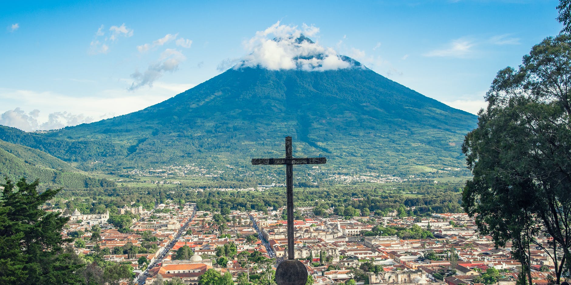
Agua Volcano is one of the great presences in the landscape of Guatemala's central highlands: an almost perfect symmetrical cone of some 3,760 meters that dominates the Antigua valley and has become one of the symbols of the old colonial capital. Anyone walking Antigua's cobbled streets has it always in front of them, watching over the city with its unmistakable silhouette.
Inactive throughout historical times, Agua Volcano doesn't offer the lava spectacle of nearby Fuego, but its ascent is one of the classic high-altitude hikes of the region. Climbing its slopes, through farmland and forest, to the nearly 3,800 meters of its summit rewards you with spectacular views of the valley, of Antigua at your feet and of the neighboring volcanoes —Fuego and Acatenango— cut out against the horizon. Its history, moreover, is tied to one of the most dramatic episodes of the conquest of Guatemala.
This guide covers Agua Volcano with a practical and warm eye: what the ascent involves, how demanding it is, where it's organized from (Antigua and Santa María de Jesús are the bases), what to bring, when to climb and how to do it safely and with a local guide. It's a demanding but accessible high-altitude adventure for anyone in decent shape, and a way to get close to the volcano that has always presided over the Antigua valley.
Agua Volcano is a stratovolcano of Guatemala's central highlands, rising on the boundary of the departments of Sacatepéquez, Escuintla and Guatemala, dominating the valley where Antigua Guatemala sits. It reaches some 3,760 meters and has a notably symmetrical cone; it is considered inactive, with no known eruptions in historical times. Its name, 'Volcán de Agua' (Water Volcano), comes from a tragic event: in 1541, a torrent of water and mud came down its slopes and destroyed the then capital, Santiago de los Caballeros de Guatemala, located in what is now Ciudad Vieja. That catastrophe forced the capital to be moved to the Panchoy valley, where Antigua was born. The disaster was traditionally attributed to a lake overflowing in the crater, though modern explanations point rather to a lahar caused by heavy rains. In pre-Hispanic times, the region was inhabited by the Maya peoples of the highlands (Kaqchikel), for whom volcanoes carried strong sacred meaning; the Maya knew it by other names, such as Hunahpú. After the Spanish conquest of 1524, led by Pedro de Alvarado, the valley at the foot of the volcano became the political heart of the Captaincy General of Guatemala. Today Agua Volcano is a symbol of the Antigua landscape and a trekking destination, with its summit crowned by communication antennas. The full geological and cultural history, including the disaster of 1541, is on our history page.
Read the full history ↓The smallest department in the country, dominated by Antigua Guatemala, the former colonial capital of Central America and a World Heritage Site, set among coffee plantations and the Agua, Fuego and Acatenango volcanoes.
Read the history of Sacatepéquez →A local guide tells you in half an hour what no sign at the site will ever explain. We look ours up on Civitatis: guided in Spanish and booked online with no fuss. They have 17 activities in Antigua Guatemala. And there are free tours here: you book without paying and tip the guide whatever you think at the end, so trying one costs you nothing. Three are below so you get the idea: tap any of them and they all open.
They depart from Antigua Guatemala, 13 km away. If you book from this link we earn a commission and you pay no more.
No exact prices: a scale from $ (budget) to $$$$$ (luxury), with 2-3 options per category.
Origins, formation and what the sources say.
It's the only volcano in Guatemala that owes its name not to fire but to water, and not to an eruption but to a night in September 1541 when an avalanche of water and mud came down its slopes and wiped the colonial capital off the map. That is the great mystery of Agua Volcano: a giant with a perfect cone, considered inactive, that nonetheless starred in one of the most famous catastrophes of colonial America. Understanding why it's called what it's called is understanding much of the history of Antigua Guatemala, the city that came into being precisely because that volcano destroyed its predecessor.
Agua Volcano is a stratovolcano of Guatemala's central highlands, rising on the boundary of the departments of Sacatepéquez, Escuintla and Guatemala, dominating the valley where Antigua Guatemala sits. It reaches some 3,760 meters and stands out for its remarkably symmetrical, almost perfect cone, which makes it one of the most recognizable silhouettes in the Guatemalan landscape.
It forms part of the Central American volcanic chain, within the great Pacific Ring of Fire, created by the subduction of the Cocos Plate beneath the Caribbean Plate off the country's Pacific coast. Agua Volcano stands near other giants of the central highlands, such as Acatenango and the hyperactive Fuego Volcano, with which it shares the horizon of the Antigua valley.
Unlike Fuego or Pacaya, Agua Volcano is considered inactive: it has no eruptions recorded in historical times, and its name and its fame come not from volcanic activity but from a water-related disaster in 1541. Its vegetation-covered cone and its summit, today crowned with communication antennas, complete its characteristic profile.
The exact height and the details of the volcano's geological history are reconstructed from scientific studies and may vary slightly between sources; treat them as figures under review.
Long before the Spanish arrived, the valley region at the foot of the volcano was inhabited by the Maya peoples of the central highlands, mainly the Kaqchikel. For them, the imposing cone that dominates the valley was not the 'Volcán de Agua' —that name would come with the Spanish after the disaster of 1541— but a sacred mountain they knew by other names, among them Hunahpú, linked to Maya mythology.
In the Maya worldview, mountains and volcanoes were spaces charged with sacred meaning, the dwelling of forces and deities, living presences in the landscape. A volcano as visible and dominant as this one, presiding over the whole valley, surely held a prominent place in the sacred geography of the highland peoples.
The Kaqchikel had important centers of power nearby, such as Iximché, their capital, and controlled much of the region. The valley at the foot of the volcano, fertile and well placed, was valuable territory, which explains why the Spanish chose to establish the capital of their new colony close to it.
The specifics about the Maya names for the volcano and its concrete role in pre-Hispanic religion combine records, oral tradition and colonial sources, so they are best taken as approximations rather than precise data.
The Spanish conquest of the Guatemalan highlands in 1524, led by Pedro de Alvarado, prompted the conquistadors to establish their capital near this volcano. After initial foundings, around 1527 the city of Santiago de los Caballeros de Guatemala was established in a valley at the foot of the volcano, in what is now Ciudad Vieja, in the heart of Kaqchikel territory.
From that capital the Captaincy General of Guatemala was governed, a vast jurisdiction covering much of Central America. The valley, fertile and temperate, seemed an ideal place to seat the center of colonial power. The volcano, with its symmetrical cone, watched over the new city from on high.
That choice of site, however, concealed a risk. Water accumulated on the volcano's slopes, and the combination of steep gradients, heavy rain and, according to traditional accounts, accumulations of water high up, left the city at its foot vulnerable. That risk would materialize tragically a few years later.
The exact dates of the capital's various foundings and the details of its establishment at the foot of the volcano vary between sources; there is agreement that the city of Santiago stood on the present site of Ciudad Vieja before the disaster of 1541.
The event that marked the volcano's history forever and gave it its name took place in 1541. On the night of 10-11 September that year, after days of heavy rain, an enormous mass of water and mud rushed down the volcano's slopes and destroyed the city of Santiago de los Caballeros, causing many deaths and near-total destruction.
Among the most celebrated victims of the disaster was Beatriz de la Cueva, widow of the conquistador Pedro de Alvarado, who shortly before had taken over the government of the colony after her husband's death —one of the very few women to govern a territory in colonial America. Her death in the catastrophe added to the drama of the episode. The scale of the disaster forced the authorities to move the capital to a new site, the Panchoy valley, where the city we know today as Antigua Guatemala was born.
It was as a result of this disaster that the volcano came to be called 'Volcán de Agua'. The catastrophe was traditionally attributed to the overflow of a great lake said to have formed in the crater, an explanation recorded by the chroniclers of the time. Modern interpretations, however, tend to explain the disaster as a lahar —a volcanic torrent of water, mud and debris— caused by torrential rain on the slopes, with no need for a lake at the summit.
The exact causes of the 1541 disaster remain under discussion: the crater-lake explanation is the traditional one, while the rain-driven lahar is the more widely accepted today; both are best presented as theories.
After the 1541 disaster, the capital moved to the Panchoy valley, where the city of Santiago de los Caballeros —today Antigua Guatemala— flourished, and where for centuries the political, religious and cultural heart of the Captaincy General of Guatemala would remain, until its own move to present-day Guatemala City after the earthquakes of 1773. Through all that history, Agua Volcano was always there, watching over the valley.
Today the perfect cone of Agua Volcano is one of the great symbols of the Antigua landscape, the backdrop to its cobbled streets, its colonial ruins and its postcards. Seeing it frame the city from viewpoints such as the Cerro de la Cruz is one of the classic images of Guatemala. The volcano and the city form an inseparable whole, recognized when Antigua was declared a World Heritage Site by UNESCO in 1979.
In recent decades, the ascent of Agua Volcano has joined the region's trekking offering, though with less fame than the spectacular Acatenango. Climbing to its summit, demanding because of the altitude, rewards you with views of the valley, of Antigua and of the neighboring volcanoes. The summit, crowned with communication antennas, also reflects the mountain's modern uses.
Agua Volcano thus sums up a deep history: a sacred mountain for the Maya, the setting of one of the most famous disasters of the conquest, an eternal symbol of Antigua and, today, a destination for those who want to walk to the top of the cone that has always presided over Guatemala's most historic valley.