Viajá con Gus
HomeEcuadorGuayaquil
Guayaquil
🇪🇨 Ecuador · Coast (Pacific)

Guayaquil

Jump to what you need
📌Province
Guayaquil is the capital of Guayas province, in Ecuador's Coast (Pacific) region. It is the country's most populous city and its main port, set on the western bank of the Guayas river, near where it flows into the Gulf of Guayaquil. People call it the 'Pearl of the Pacific', a nickname that comes from its past as a thriving, cosmopolitan port. Its full official name is Santiago de Guayaquil, and it is the great commercial and economic engine of the Ecuadorian coast, as well as the most convenient jumping-off point for the Galápagos Islands and the Ruta del Spondylus.
📌Service town
Guayaquil itself has every service you need. Its José Joaquín de Olmedo International Airport (code GYE), a few kilometres from the centre, is one of the two air gateways to the Galápagos (along with Quito) and handles domestic and international flights. It has a large long-distance bus terminal (the Terminal Terrestre Jaime Roldós Aguilera, right next to the airport), the Metrovía mass transit system (BRT), taxis and apps, a wide network of hotels, hospitals, banks and tourist offices. It is the natural base for exploring the Guayas coast, the Ruta del Spondylus (Montañita, Puerto López) and for heading out to the Galápagos.
📌Best time
Guayaquil has a warm tropical climate all year, with two seasons marked by the rain rather than by the temperature. The dry season (roughly June to December) is cooler, cloudier and windier, with less rain and more bearable temperatures: for many people, the most comfortable time to walk the city. The wet or rainy season (January to May) brings intense heat, high humidity, strong sun and tropical downpours, mostly in the afternoon. Always bring sun protection, water and light clothing. The big festivals are the city's founding (in July) and, above all, its independence on 9 October, when the city fills with events.
📌Suggested days
Two days cover the essentials of the centre: the Malecón 2000 end to end, the historic Las Peñas neighbourhood with the climb up Cerro Santa Ana and its lighthouse, Parque Seminario with its famous iguanas opposite the Cathedral, and a sunset by the Guayas river. With 3 or 4 days you can add the Parque Histórico Guayaquil in Samborondón, Isla Santay (a wetland reached by a pedestrian and cycle bridge), the Malecón del Salado, the museums downtown (such as the MAAC) and a day trip. Guayaquil also works very well as a one-night base before or after travelling to the Galápagos or driving the Ruta del Spondylus.
💱 USD exchange rate
Loading rate…
🌤️ Weather in Guayaquil
Loading weather…

Guayaquil is the big city of the Ecuadorian coast: Caribbean in its heat, a port town in character and proud of its identity. Known as the 'Pearl of the Pacific', it spreads along the bank of the wide Guayas river, that brown and powerful river that for centuries was its reason for being and its window on the world. It is Ecuador's main port and most populous city, a bustling, commercial, lively place where the coastal rhythm shows in the street, in the food and in the direct, warm manner of its people, the guayaquileños.

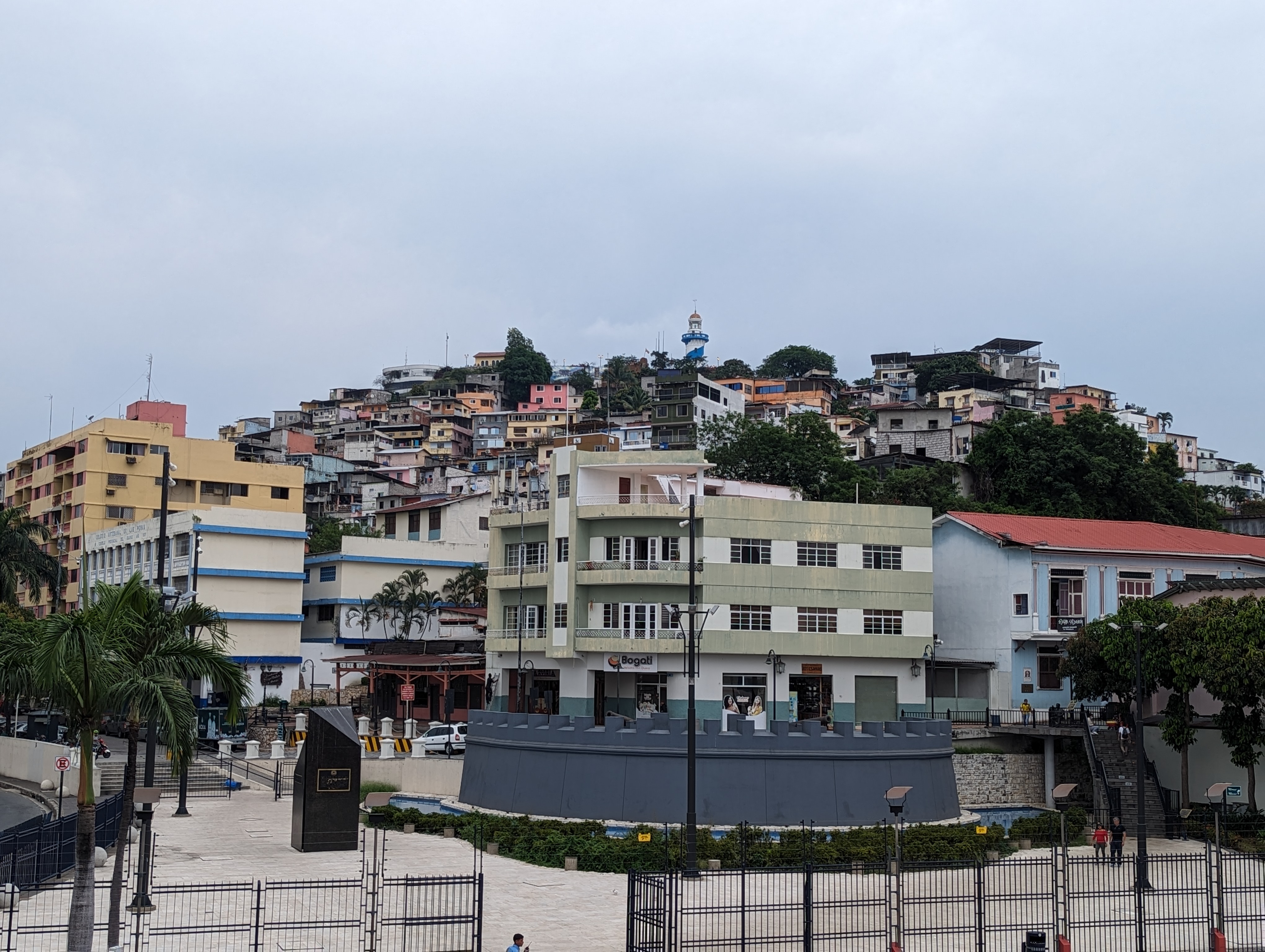
For a long time Guayaquil was a city you passed through, a port you only reached to catch the plane to the Galápagos. That changed with the great urban regeneration of the late 1990s, which turned the riverfront into the Malecón 2000, brought back the historic Las Peñas neighbourhood and made Cerro Santa Ana —with its 444 coloured steps, its chapel and its lighthouse— one of the city's great walks. Today Guayaquil invites you to stay: to walk its riverfront, to climb the hill at sunset, to be surprised by the iguanas strolling through Parque Seminario in the middle of downtown.

This guide covers the essentials of Guayaquil with a practical, warm eye: what to see downtown and along the river, how to climb Cerro Santa Ana, where to find nature without leaving the city (Isla Santay, the estero Salado, the Parque Histórico), how to get around and with what common sense. It's a city best enjoyed unhurried, letting yourself be carried by its port energy and by that river that explains everything.

📖 History of Guayaquil

The Guayas river region was inhabited long before the Spanish arrived by indigenous coastal peoples, chiefly the Huancavilca and the Puná (from Isla Puná), sailors and traders who dominated these waters. The Spanish founding of Santiago de Guayaquil took several attempts: there were early foundings around 1534, by Sebastián de Benalcázar, and in 1535, but the definitive founding is traditionally attributed to Francisco de Orellana around 1537-1538, when the city settled at the foot of Cerro Santa Ana, in what is today the Las Peñas neighbourhood. Being a major port made it a coveted target: during the 17th century it suffered several sieges and sackings by pirates and buccaneers, who attacked the city in search of the gold and goods passing through its anchorage. Guayaquil prospered as an export port, first of cacao —the famous 'pepa de oro' that made the city's fortune in the 18th and 19th centuries— and later of bananas in the 20th century. Its most glorious page came on 9 October 1820, when Guayaquil became the first Ecuadorian city to declare independence from Spain, proclaiming itself the 'Free Province of Guayaquil'; out of that feat came its anthem, '¡Ya el sol vuelve a alumbrar!'. Two years later, in July 1822, the city was the setting for the historic Guayaquil Conference, the famous and enigmatic meeting between Simón Bolívar and José de San Martín that sealed the fate of South American independence. The city also suffered great fires, such as the devastating 'Incendio Grande' of 1896, which razed much of the old wooden quarter. In the late 20th century, the great urban regeneration of the Malecón 2000 (opened between 1999 and 2000) reconciled the city with its river. The full story is on our history page.

Read the full history ↓

🏛️ Guayaquil is in Guayas

The economic heart of the Coast: land of the huancavilcas, cradle of Guayaquil —the «Pearl of the Pacific»—, the country's main port and historic shipyard, stage of the independence of 1820, of Alfaro's railway and of coastal liberalism.

Read the history of Guayas →

🗺️ What to see

1
Malecón 2000 (Malecón Simón Bolívar)
Guayaquil's great riverside promenade on the Guayas, the symbol of the city's urban regeneration.
The Malecón 2000, officially the Malecón Simón Bolívar, is the heart and the pride of modern Guayaquil. It is a long pedestrian promenade of some 2.5 kilometres running along the bank of the Guayas river, from the Las Peñas neighbourhood in the north to the Mercado Sur (Palacio de Cristal) in the south. It opened right around the year 2000 as the flagship work of the great urban regeneration that gave the people of Guayaquil their riverfront back, a stretch of shore that had been run down for decades. Walking it is the best way to get into the city. Along the malecón come gardens, fountains, viewpoints over the river, monuments, museums, food courts, a giant ferris wheel (La Perla) and jetties where boat trips on the Guayas set off. It is an enclosed, patrolled space designed for a calm walk, and it draws families, couples and tourists at all hours, but especially at sunset, when the sun goes down over the river and the city lights up. Among its landmarks are La Rotonda (the hemicycle with the monument to the meeting of Bolívar and San Martín), the botanical gardens at the southern end, the civic squares with their monuments to the independence leaders, and the access to the Las Peñas neighbourhood and Cerro Santa Ana at the northern end. It also houses the Anthropological and Contemporary Art Museum (MAAC) and cinema screens. Getting there: it's right downtown, reachable on foot, by taxi/app or on the Metrovía. Best time of day: sunset is the magic moment, with good light and kinder temperatures; by day bring sun protection because of the heat. Tips: combine it with the climb up Cerro Santa Ana and the Las Peñas neighbourhood (they're at the same end) and leave time for a boat trip on the river.
ℹ️ Distance: City centre, on the bank of the Guayas river (on foot, by taxi/app or Metrovía) · Best time: Sunset (best light and temperature); by day bring sun protection · Admission: Free (open access); attractions inside such as La Perla charge separately (US$ 3.50 Mon-Fri, US$ 5 weekends and public holidays, verified July 2026) · Duration: 2 to 3 hours (more if you add a boat trip)
2
Las Peñas (colonial quarter and calle Numa Pompilio Llona)
The oldest neighbourhood in Guayaquil, with colourful wooden houses, artists' studios and cobbled streets.
Las Peñas is the oldest and most emblematic neighbourhood in Guayaquil, the corner where the city was born, at the foot of Cerro Santa Ana. It's a cluster of colourful wooden houses, balconies and cobbled streets that survived the fires and floods of history and is today listed as heritage. Walking it is a trip to the Guayaquil of old, the city of the port and the shipyards, far from the noise of the commercial centre. Its main street is calle Numa Pompilio Llona, a narrow cobbled lane that winds among old houses, many of which were home to artists, writers and presidents of Ecuador (there are plaques to prove it). Today the neighbourhood holds art galleries, studios, cafés, bars and small shops, in a bohemian, artistic atmosphere that comes alive mostly in the afternoon and evening. Las Peñas links directly with Cerro Santa Ana by its famous stairway, so many visitors walk the historic quarter at river level first and then climb the 444 steps up to the lighthouse. From its corners, views open out over the Guayas river and the old shipyards. It's a good place for a drink, for buying local art and for feeling the old soul of the city. Getting there: it's at the northern end of the Malecón 2000, walkable from there, or by taxi/app. Best time of day: afternoon and sunset, when the cafés and galleries open and the light is softer. Safety tips: it's a tourist area and reasonably well looked after, but stick to the busy streets, go by day or early in the evening, carry little cash and mind your phone. Comfortable shoes for the cobbles and the climb up the hill.
ℹ️ Distance: Northern end of the Malecón 2000, at the foot of Cerro Santa Ana (on foot or by taxi/app) · Best time: Afternoon and sunset (cafés and galleries open, soft light). By day or early evening · Admission: Free (open access) · Duration: 1 to 2 hours (can be combined with Cerro Santa Ana)
3
Cerro Santa Ana (the 444 steps, the lighthouse and the chapel)
Guayaquil's founding hill, with 444 numbered coloured steps, a chapel, a lighthouse and views over the whole city.
Cerro Santa Ana is one of the great symbols of the renewed Guayaquil and one of its unmissable walks. It is the hill at whose foot the city was born, next to the Las Peñas neighbourhood, and which after the urban regeneration of the early 2000s was turned into a colourful stairway climbing to the top. The route runs up 444 numbered steps, lined with houses painted in bright tones, cafés, bars, craft shops and small viewpoints. The climb, though it takes some effort in the heat, comes with natural pauses: every so often there's a café for something cold, a terrace with a view or a numbered step telling you how far is left. At the top the reward waits: the Chapel of Santa Ana, the remains of the old Fortín del Cerro (with cannons recalling the city's defence against pirates) and, above all, the lighthouse, a viewpoint that opens onto a 360-degree panorama over Guayaquil, the wide Guayas river, the Las Peñas neighbourhood and the bridges crossing towards Samborondón and Durán. It's one of the best places in the city to watch the sunset and the lights coming on over the river. The atmosphere is lively and touristy, with music and life in the cafés, especially as evening falls and at weekends. Getting there: you walk up from the Las Peñas neighbourhood, at the northern end of the Malecón 2000. Best time of day: sunset is the pick, but start the climb while there's still light; by day bring water and sun protection because of the heat. Safety tips: the steps area is looked after and patrolled; stay on the main lit route, carry little cash and mind your phone. Comfortable shoes and, above all, take the climb slowly.
ℹ️ Distance: Next to Las Peñas, northern end of the Malecón 2000 (climb on foot) · Best time: Sunset (views and lights); start the climb while it's light. Bring water · Admission: Free (open access); cafés and shops charge for what you order (a coffee or a beer runs about US$ 1.50–4, verified July 2026) · Duration: 1.5 to 2 hours (climb, lighthouse and descent)
4
Parque Seminario (Iguana Park)
The surprising downtown square where dozens of green iguanas live alongside people, opposite the Cathedral.
Parque Seminario, fondly known as the 'Parque de las Iguanas' (and sometimes as Parque Bolívar), is one of the most curious and best-loved sights in Guayaquil. It's a landscaped square right in the city centre, opposite the Metropolitan Cathedral, famous because a large population of green iguanas lives there freely, strolling over the lawn, climbing the trees and letting themselves be seen calmly among the visitors. Seeing these big reptiles sunning themselves on the paths, on the benches and in the branches, in the middle of the urban bustle, is as unexpected as it is endearing. The iguanas share the park with turtles in the pond and with pigeons, in a small oasis of nature ringed by buildings. It's a very popular spot for photos, especially with children, though you shouldn't feed or bother them and should follow the signs on site. At the centre of the park stands an equestrian monument to Simón Bolívar, and around it are benches, gardens with iron railings and a bandstand. The whole thing, facing the imposing neo-Gothic Cathedral, makes one of the most photogenic corners of the historic centre. Getting there: it's right downtown, on avenida 9 de Octubre / calle Chimborazo, a few blocks from the Malecón 2000; reachable on foot, by taxi/app or on the Metrovía. Best time of day: morning, when the iguanas come out to sun themselves and it's less hot. Tips: combine it with a visit to the Cathedral, which is right across the way, and a walk through the centre towards the malecón. Bring sun protection and water.
ℹ️ Distance: Historic centre, opposite the Cathedral, a few blocks from the Malecón 2000 (on foot, by taxi/app or Metrovía) · Best time: Morning (iguanas active in the sun, less heat) · Admission: Free (open access) · Duration: 30 to 45 minutes (can be combined with the Cathedral)
5
Metropolitan Cathedral of Guayaquil
The great neo-Gothic church downtown, opposite Iguana Park, with its white towers and stained glass.
The Metropolitan Cathedral of Guayaquil, dedicated to Saint Peter the Apostle, is the city's main Catholic church and one of the most recognisable buildings in its historic centre. It stands opposite Parque Seminario (the Parque de las Iguanas), forming with it one of the most photographed urban scenes in Guayaquil. The current neo-Gothic building replaced earlier churches destroyed by the fires that swept the wooden city over the course of its history. Its white façade, with two towers and a great rose window, stands out among the downtown buildings. The interior, with high, bright naves, keeps colourful stained glass, slender columns and a quiet atmosphere that contrasts with the noise of the street. It's a good pause to take in the city's religious architecture and get out of the heat. The Cathedral is a natural part of the historic centre circuit: it's steps from Parque Seminario and a few blocks from the Malecón 2000, so you can take it in on the same walk. Outside its doors, the park's iguanas complete a very guayaquileño postcard. Getting there: right downtown, on calle Chimborazo, opposite Parque Seminario; on foot, by taxi/app or Metrovía. Best time of day: morning, when it's less hot and it pairs well with the Parque de las Iguanas; check mass times before visiting. Tips: dress respectfully when entering the church, keep quiet and combine the visit with the park across the street and the rest of the centre.
ℹ️ Distance: Historic centre, opposite Parque Seminario (on foot, by taxi/app or Metrovía) · Best time: Morning; check mass times before visiting · Admission: Free access (a working church; respect the times) · Duration: 20 to 30 minutes (can be combined with the Parque de las Iguanas)
6
La Perla (the Malecón 2000 ferris wheel)
One of the tallest ferris wheels in South America, on the Malecón 2000, with views over the Guayas river.
La Perla is Guayaquil's big ferris wheel, installed on the Malecón 2000 opposite the Las Peñas neighbourhood, and it has become one of the visual icons of the modern city. At more than fifty metres tall, it is considered one of the tallest observation wheels in South America, and its lit silhouette at night has become part of the river landscape. The appeal is riding one of its enclosed, air-conditioned cabins and going round while taking in, from up high, a panorama of the Guayas river, the malecón, Cerro Santa Ana with its lighthouse, the Las Peñas neighbourhood and the bridges towards Samborondón and Durán. It's a different and fun way to see the city, especially attractive at sunset and at night, when everything lights up. It's designed for all ages, with family cabins, and it's one of the favourite outings for anyone walking the malecón. Since it's a paid attraction inside a free-access space, check the opening times and ticket prices on the spot, as they can change. Getting there: inside the Malecón 2000, in its northern section, near the access to Las Peñas; on foot from the malecón. Best time of day: sunset or at night, for the views and the city lights. Tips: combine it with the walk along the malecón, the climb up Cerro Santa Ana and a wander through Las Peñas, which are all in the same area. Bring cash or a card for the ticket.
ℹ️ Distance: Northern section of the Malecón 2000, near Las Peñas (on foot from the malecón) · Best time: Sunset and night (views and city lights) · Admission: Paid: US$ 3.50 (Mon-Fri) and US$ 5 (Sat, Sun and public holidays); seniors and people with disabilities US$ 1.74–2.50 (source: the attraction's official site, verified July 2026) · Duration: 20 to 40 minutes
7
Parque Histórico Guayaquil (Samborondón)
A park that recreates old Guayaquil in three zones: wildlife, traditions and urban architecture.
The Parque Histórico Guayaquil is one of the most complete and enjoyable outings in the metropolitan area, on the other side of the river, in Samborondón (in the vía Samborondón / Entre Ríos area). It's an open-air cultural and natural space that recreates the history, nature and traditions of old Guayaquil and the Guayas region, ideal for a family visit and half a day between nature and heritage. The park is organised in three big zones. The Wildlife Zone reproduces the coastal ecosystems (such as the mangrove) and houses native fauna in semi-freedom, with raised walkways from which you can watch birds, monkeys, sloths, tapirs and other species. The Traditions Zone recreates rural life on the coast, with a hacienda house, typical crops (cacao, coffee, rice) and displays of montubio culture. And the Urban-Architectural Zone rebuilds the malecón and streets of early 20th-century Guayaquil, with heritage houses that were rescued and restored. It's a place designed to be taken slowly, walking its paths, learning about the history and nature of the Ecuadorian coast and enjoying green surroundings a few steps from the city. It gets very busy at weekends. Getting there: it's in Samborondón, across the river; the easiest way is by taxi/app or car. Best time of day: morning, when it's cooler and the wildlife is more active; confirm the opening days and hours, as it usually closes one day a week. Tips: bring repellent, water, sun protection and comfortable shoes, and leave time for all three zones.
ℹ️ Distance: Samborondón, across the Guayas river (taxi/app or car) · Best time: Morning (cooler weather, active wildlife); confirm opening days · Admission: General access free; the Wildlife Zone charges US$ 1 (seniors and people with disabilities) and is free for everyone else and for children under 5 (source: official sites / local prices, verified July 2026) · Duration: Half a day
8
Isla Santay (Ramsar wetland and eco-village)
A protected wetland island facing the city, reached by a pedestrian and cycle bridge, with mangroves and an eco-village.
Isla Santay is one of the most surprising nature outings in Guayaquil: a river island in the middle of the Guayas, facing the city, turned into a National Recreation Area and recognised as a wetland of international importance (a Ramsar site). It's a green lung of mangroves, lagoons and trails a few minutes from downtown, ideal for a nature escape without leaving the urban area. The most special part is how you get there: a pedestrian and cycle bridge crosses the river from Guayaquil to the island (and another links it with the city of Durán), so you reach it walking or cycling, with no boat needed. Once on the island, raised wooden walkways run in among the mangroves, letting you watch birds, crabs and the life of the wetland. The island also has a small Eco-village, a community that lives there sustainably, and a crocodile breeding station. It's a quiet plan, much chosen by guayaquileños for a walk or a ride at weekends, in contact with nature and with good views of the city skyline from the river. You can rent bikes to cover more ground in comfort. Getting there: on foot or by bike over the pedestrian bridge that crosses the river from Guayaquil (there's usually an access near the south of the centre/El Oro); confirm the exact point and the access hours. Best time of day: early morning, when it's cool and the birds are active, avoiding the strong midday sun. Tips: bring water, sun protection, repellent and a hat; check the opening hours and the tour times before you go.
ℹ️ Distance: An island in the Guayas river, facing the city; access on foot or by bike over the pedestrian bridge · Best time: Early morning (cool weather, active birds) · Admission: Access to the island is free; bike rental runs about US$ 3–5 an hour (source: official sites / local prices, verified July 2026) · Duration: Half a day
9
Malecón del Salado (estero Salado)
The waterfront promenade along the estero Salado, with pedestrian bridges, fountains and restaurants, in the heart of the city.
The Malecón del Salado is Guayaquil's other great waterside promenade, less famous than the Malecón 2000 but much loved by locals. It runs along the banks of the estero Salado, a brackish arm of water surrounded by mangroves that cuts through the city, in the area near avenida 9 de Octubre and the University of Guayaquil. It too is the fruit of the urban regeneration projects that recovered the city's waterfronts. The promenade combines pedestrian esplanades, gardens, fountains (some with water and light shows), bridges that cross the estuary and a zone of restaurants and eateries where you can try coastal cooking by the water. It's a pleasant place to walk, especially at sunset, when the heat drops and the lights come on over the water. From here you can take small boat trips along the estero Salado, another way to get to know the mangrove ecosystem that surrounds the city. The atmosphere is local and family-friendly, a good way to see a more everyday Guayaquil, away from the more touristy circuit along the Guayas. Getting there: in the centre-west of the city, near avenida 9 de Octubre; by taxi/app or Metrovía. Best time of day: sunset and early evening, for the temperature and the lit fountains. Safety tips: as on any city walk, stick to busy, well-lit areas, carry little cash and mind your phone. A good plan to combine with a lunch or dinner of typical coastal food.
ℹ️ Distance: Centre-west, next to avenida 9 de Octubre (taxi/app or Metrovía) · Best time: Sunset and early evening (temperature and lights) · Admission: Free (open access); a boat trip on the estuary runs about US$ 2–5 per person (source: official sites / local prices, verified July 2026) · Duration: 1 to 2 hours
10
Anthropological and Contemporary Art Museum (MAAC)
The big museum on the Malecón 2000, with archaeology of the pre-Columbian coastal cultures and contemporary art.
The Anthropological and Contemporary Art Museum, known by its Spanish initials MAAC, is Guayaquil's main museum and a highly recommended visit for understanding the historical depth of the region. It's built into the Malecón 2000, in its northern section, near Las Peñas, which makes it easy to combine with the walk along the riverfront. Its archaeological collection is one of Ecuador's great treasures: thousands of pieces from the pre-Columbian cultures that lived on the coast, such as Valdivia (one of the oldest in the Americas, famous for its ceramic 'Venus' figures), Chorrera, Machalilla, Jama-Coaque, Bahía, Guangala and the Huancavilca culture, among others. Through ceramics, figures, tools and goldwork, the museum tells millennia of history of the coastal peoples who came before Spanish Guayaquil. The museum's other great strand is contemporary art, with rooms of temporary and permanent exhibitions by Ecuadorian and regional artists, plus a space devoted to the performing arts and cinema. It's a modern, air-conditioned, well-laid-out museum, ideal for a culturally rich break from the city heat. Getting there: inside the Malecón 2000, northern section; on foot from the malecón or by taxi/app. Best time to go: any opening day; confirm the hours and the weekly closing day before you go. Tips: combine it with the walk along the Malecón 2000, Las Peñas and Cerro Santa Ana, which are all in the same area. Check whether there's free admission on a particular day or time slot.
ℹ️ Distance: Northern section of the Malecón 2000, near Las Peñas (on foot or by taxi/app) · Best time: Opening days; confirm the hours and the weekly closing day · Admission: Free admission (open access, the MAAC's free-entry policy, verified July 2026; check the hours and the weekly closing day) · Duration: 1 to 2 hours
11
La Rotonda (monument to the Bolívar–San Martín meeting)
The hemicycle on the Malecón 2000 that commemorates the historic 1822 Guayaquil Conference between the two liberators.
La Rotonda is one of the most significant monuments in Guayaquil and a compulsory stop inside the Malecón 2000. It is an imposing hemicycle of columns facing the Guayas river, wrapped around a bronze sculptural group: the figures of Simón Bolívar and José de San Martín shaking hands. The monument commemorates the historic Guayaquil Conference, the famous and enigmatic meeting between the two great liberators of the Americas, which took place in the city in July 1822. That meeting, whose exact content is still debated by historians, was a decisive moment for the fate of South American independence: after it, San Martín withdrew from public life and left Bolívar to lead the independence cause on the continent. La Rotonda immortalises that symbolic instant in the very place where history was decided, on the banks of the Guayas. The monument also has a famous acoustic quirk: thanks to its hemicycle shape, two people standing at opposite ends can whisper and hear each other clearly from one side to the other, an effect visitors love. Lit up at night, La Rotonda is one of the loveliest sights on the malecón. Getting there: inside the Malecón 2000, on avenida 9 de Octubre, at the point where it reaches the river; on foot along the malecón. Best time of day: sunset and at night, when it's lit and it's less hot. Tips: try the whispering effect while you're there, and combine it with the rest of the malecón. It's an excellent spot for photos with the river behind you.
ℹ️ Distance: Malecón 2000, where avenida 9 de Octubre reaches the river (on foot along the malecón) · Best time: Sunset and night (lit up, less heat) · Admission: Free (open access) · Duration: 20 to 30 minutes
12
Mercado Sur (Palacio de Cristal) and Plaza Cívica
The historic iron-and-glass market at the southern end of the Malecón 2000, today an exhibition and events venue.
The Mercado Sur, known as the Palacio de Cristal, is a heritage gem at the southern end of the Malecón 2000. It's an elegant iron-and-glass structure from the early 20th century, in a style close to the great European buildings of the period (it recalls the crystal palaces and iron markets of industrial architecture), which served for decades as the city market. Restored as part of the malecón regeneration project, it is today a cultural space hosting exhibitions, fairs and events. Its transparent metal frame, its large windows and its brightness make it one of the most photogenic buildings on the waterfront. It's surrounded by the gardens of the southern section of the malecón, a quieter, greener area that invites a relaxed walk by the river, away from the busier stretch. Along the malecón, too, are various squares and civic monuments —such as the Plaza Cívica with its columns and tributes to the leaders of independence— that tell the story of the city and the feat of 9 October 1820 in the open air. Walking this end of the Malecón 2000 is a good way to close a visit to the riverfront, combining heritage, gardens and views over the Guayas. Getting there: southern end of the Malecón 2000; on foot along the malecón, by taxi/app or Metrovía. Best time of day: in the afternoon, combining it with a walk along the malecón towards sunset; check whether there's an exhibition or fair on at the time. Tips: take the chance to walk the quieter gardens at the southern end of the malecón, and the monuments of the Plaza Cívica on the same outing.
ℹ️ Distance: Southern end of the Malecón 2000 (on foot along the malecón, taxi/app or Metrovía) · Best time: In the afternoon, can be combined with the malecón; check what exhibitions are on · Admission: Free (open access); some temporary exhibitions or fairs may charge a token amount (roughly US$ 1–3; source: local prices, verified July 2026) · Duration: 30 to 45 minutes
Advertisements
What nobody tells you

💵 Prices

Tickets

TypePrice
Malecón 2000 (the promenade)Free (open access)
Las Peñas and calle Numa Pompilio LlonaFree (open access)
Cerro Santa Ana (444 steps, lighthouse and chapel)Free (open access)
Parque Seminario (Iguana Park)Free (open access)
Metropolitan Cathedral of GuayaquilFree access (a working church; respect the times)
La Perla (the Malecón 2000 ferris wheel)US$ 3.50 (Mon-Fri) and US$ 5 (Sat, Sun and public holidays); express ticket US$ 7–10; seniors and people with disabilities US$ 1.74–2.50 (source: the attraction's official site, verified July 2026)
Parque Histórico Guayaquil (Samborondón)General access free; the Wildlife Zone charges US$ 1 to seniors and people with disabilities (free for everyone else and for children under 5), verified July 2026
Isla SantayAccess to the island is free; bike rental roughly US$ 3–5 an hour (source: official sites / local prices, verified July 2026)
Malecón del SaladoFree (open access); a boat trip on the estuary roughly US$ 2–5 per person (source: market prices / local operators, verified July 2026)
Anthropological and Contemporary Art Museum (MAAC)Free admission (open access, the MAAC's free-entry policy, verified July 2026; check the hours and the weekly closing day)
Mercado Sur (Palacio de Cristal)Free (open access); temporary fairs or exhibitions may charge roughly US$ 1–3 (source: market prices / local operators, verified July 2026)
🔄 updated monthlyOfficial / reference values · double-check when buying

Activities and tours

ActivityPriceDurationOperator
Classic city tour (Malecón 2000 + Las Peñas + Cerro Santa Ana + Iguana Park)US$ 35–60 per person in a small group (source: market prices / local operators, verified July 2026), with transport and guide; larger group tours come down to ~US$ 25–40Half a dayLocal agencies and guides (Civitatis, Ecuador Expeditions and operators on the malecón)
Catamaran / boat trip on the Guayas river (from the Malecón or Puerto Santa Ana)US$ 5–15 per person on a regular trip (1 h); private trips or dinner cruises from US$ 30–60 (source: market prices / local operators, verified July 2026)1-2 hRiver trip operators on the malecón and at Puerto Santa Ana
Guided visit to Isla Santay (on foot or by bike)Access free; bike rental US$ 3–5 an hour; guided bike tour US$ 15–25 per person (source: market prices / local operators, verified July 2026)Half a dayLocal guides and bike rental at the island access
Tour of the Parque Histórico Guayaquil (Samborondón)General admission free (Wildlife Zone US$ 1 for seniors and people with disabilities); guided excursion with transfer from the centre US$ 20–40 (source: market prices / local operators, verified July 2026)Half a dayParque Histórico / Guayaquil agencies
Boat trip on the estero Salado (Malecón del Salado)US$ 2–5 per person (source: market prices / local operators, verified July 2026)30–60 minEstero Salado operators
Coastal food tour (encebollado, ceviche, crab)US$ 40–80 per person depending on the tastings and the length (source: market prices / local operators, verified July 2026)Half a dayLocal food guides and tours
Day trip to the Ruta del Spondylus / Guayas beachesUS$ 60–120 per person depending on the destination and the group (source: market prices / local operators, verified July 2026)Full dayGuayaquil travel agencies
Connection to the Galápagos (flights from José Joaquín de Olmedo airport)GYE–Galápagos flight from ~US$ 150–350 return; add the Park entry tax (US$ 200 for adult foreign visitors since 2024; US$ 6 for nationals) and the transit control card US$ 20 (source: market prices / local operators, verified July 2026)Roughly a 2 h flightAvianca, LATAM and Galápagos operators
🔄 updated monthlyOfficial / reference values · double-check when buying
Advertisements

🚌 How to get there and distances

Getting around

ModePriceDurationNotes
Metrovía (BRT bus system)US$ 0.45 per ride (general fare; US$ 0.30 with the La Guayaca card for priority groups and US$ 0.15 for students under 18) (source: El Universo / Expreso, verified July 2026). Cash is NOT accepted: you pay by tapping the card on the validatorVariableBuses on dedicated lanes covering the city's main corridors (centre, north and south). The payment method is the electronic 'La Guayaca' card (a contactless prepaid VISA launched in April 2026, free and topped up at stations, mobile/web banking and Mi Vecino points), which replaces the old Metrovía card. To check routes, stops and the bus's live location, the app people in Guayaquil use is Moovit. Travel light and mind your belongings at peak times
Taxi and apps (Uber, inDrive, Cabify)A short ride downtown from US$ 2–3; medium runs US$ 4–8; airport to the centre US$ 5–8 (source: local prices / apps, verified July 2026; depending on the route and the app)VariableThe most convenient and advisable option, especially at night and for areas the Metrovía doesn't reach. Use apps (which show the fare and the driver in advance and let you pay by card or cash) or registered taxis; on the street, agree the fare or ask for the meter
Aerovía (urban cable car over the river)US$ 0.76 per ride (general fare in force since 1 July 2026; concession fare US$ 0.38 for seniors, children, students and people with disabilities) (source: Expreso / Vistazo, verified July 2026). You pay with a rechargeable card bought at the stations, not in cashVariableA cable transport system that crosses the Guayas river linking Guayaquil with Durán. As well as transport, it offers panoramic views of the river and the city; useful and scenic at the same time
Conventional city busesUS$ 0.45 per ride, general fare (US$ 0.30/0.15 with La Guayaca depending on the group) (source: Guayaquil fares ordinance, verified July 2026)VariableA wide network across the whole city, progressively integrated into payment with the La Guayaca card (cash is falling out of use). Very cheap, but less comfortable for a visitor; at night it's better to take a taxi/app for safety. Moovit also covers these lines in real time
On foot around the centre and the riverfrontFreeVariableThe historic centre, the Malecón 2000, Las Peñas and Cerro Santa Ana are all very walkable. Bring water and sun protection and stick to busy, well-lit areas
Bike (cycle lanes and rental, e.g. Isla Santay)Rental roughly US$ 3–5 an hour (source: market prices / local operators, verified July 2026)VariableThere are stretches of cycle lane and bike rental, very useful for covering Isla Santay via its pedestrian bridge and for rides along the river
🔄 updated monthlyOfficial / reference values · double-check when buying

How to get there

RouteAirlines / operatorsAvg. priceDuration
José Joaquín de Olmedo airport (GYE) → centre / Malecón (taxi or app)Airport taxis and apps (Uber, inDrive, Cabify)US$ 5–8 roughly (source: local prices / apps, verified July 2026; the airport is a few km from the centre)15 to 30 min depending on traffic
José Joaquín de Olmedo airport (GYE) → city (Metrovía / bus)Metrovía (Line 3) and city busesUS$ 0.45 per ride (source: market prices / local operators, verified July 2026)Variable depending on the destination and transfers
Arriving by long-distance bus (Terminal Terrestre Jaime Roldós Aguilera)National bus cooperatives (CLP, Reina del Camino, Transportes Ecuador, etc.)Quito–Guayaquil US$ 10–14; Cuenca–Guayaquil US$ 8–12; Montañita/Puerto López US$ 6–10 (source: market prices / local operators, verified July 2026)Depending on where you start (Quito ~8 h, Cuenca ~4 h, Montañita ~3 h)
Domestic flights to Guayaquil (GYE) from Quito, Cuenca, etc.Avianca, LATAM, EquairQuito–Guayaquil from ~US$ 60–100 depending on how far ahead you book (source: market prices / local operators, verified July 2026)Quito–Guayaquil about 50 min in the air
Guayaquil → Galápagos connection (flights from GYE)Avianca, LATAMFlight from ~US$ 150–350 return; add the Park entry tax (US$ 200 for adult foreign visitors, US$ 6 for nationals) and the transit control card US$ 20 (source: market prices / local operators, verified July 2026)Roughly a 2 h flight to the islands
🔄 updated monthlyOfficial / reference values · double-check when buying

🏨 Where to stay

No exact prices: a scale from $ (budget) to $$$$$ (luxury), with 2-3 options per category.

CategoryPriceRecommended options
Luxury / business (north side and Samborondón)$$$$$US$ 120–250 a night. International chain and upmarket hotels in the northern financial area (Kennedy, Alborada) and in Samborondón, with a pool, spa and business centre; e.g. Wyndham Guayaquil, Hilton Colón, Sheraton, Oro Verde. For maximum comfort or work trips
Charm and boutique in Las Peñas / historic centre$$$$$US$ 70–140 a night. Boutique hotels and guesthouses with character around Las Peñas and Puerto Santa Ana, close to Cerro Santa Ana and the malecón; a quieter, more artistic atmosphere
Mid-range downtown / near the Malecón$$$$$US$ 45–85 a night. A good supply of mid-range hotels downtown and near the Malecón 2000, steps from the sights, the river and the food; e.g. Grand Hotel Guayaquil, Unipark, Las Peñas. Practical for getting around on foot
Budget / hostels (centre and near the Malecón)$$$$$US$ 15–40 a night (a dorm bed from ~US$ 12; a budget private room US$ 25–40). Hostels and cheap hotels downtown and around the Malecón, chosen by backpackers and travellers passing through on their way to the Galápagos; stick to safe, well-lit areas

🍴 Where to eat

TypePriceOptions / signature dish
Cevicherías and seafood cooking (ceviche, encebollado, crab)$$$$$US$ 6–18 a dish. The soul of the Guayaquil table: ceviches of shrimp, clam or fish, the classic encebollado (albacore soup with cassava and onion, the city's signature dish) and crab (a tray of crabs runs about US$ 15–30). Cevicherías and crab houses all over the city and along the malecón
Traditional coastal cooking (arroz con menestra, bolón, patacones)$$$$$US$ 4–9 a dish. Typical coastal food: rice with lentil or bean stew and meat or fish, bolón de verde, patacones, guatita, seco de pollo or de chivo and the Guayaquil breakfast of bolón and coffee. Picanterías and eateries in every neighbourhood
Restaurants and food courts on the Malecón / modern districts$$$$$US$ 12–35 a dish. Restaurants with river views on the Malecón 2000 and modern, international places in Urdesa, Samborondón and the north; food-and-drink hubs with bars and chef-driven cooking (a full meal can go over US$ 40 per person)
Markets and cheap street food$$$$$US$ 1–4 a portion. Fresh juices, empanadas, humitas, bolón, corn on the cob, fritada and food by the portion in markets and at stalls. Cheap and tasty; go for busy stalls that look well kept
Advertisements

📖 History of Guayaquil

Origins, formation and what the sources say.

Before the city: Huancavilca, Puná and the peoples of the river

Long before there was any city, the banks of the Guayas river and the gulf that carries the same name were inhabited by indigenous peoples of the Ecuadorian coast. The main ones were the Huancavilca, a confederation of coastal chiefdoms, and the Puná, who lived on Isla Puná, at the mouth of the gulf. They were societies of fishers, farmers and sailors and, above all, skilled traders who controlled maritime traffic along the Pacific coast.

These peoples were part of a long cultural tradition on the coast, heirs to civilisations thousands of years old such as Valdivia —one of the oldest ceramic cultures in the Americas—, Chorrera, Machalilla and, later, Manteño-Huancavilca. Their long-distance trade, carried on log rafts with sails, connected the Ecuadorian coast with regions as far away as northern Peru and, according to many readings, with Mesoamerica, through the exchange of the spondylus shell, a sacred mollusc of great ritual value.

When the Spanish arrived, the Guayas region was a rich and contested territory. The Puná in particular put up tenacious resistance to the conquest, and the clashes between Spaniards and indigenous peoples marked the first, difficult attempts to found a city in these lands. The mark of those peoples survives in the very name of the river and the province —Guayas— and in the coastal identity of the region.

Huancavilca and Puná as the original inhabitants
The sources agree that the Guayas estuary region was inhabited by peoples of Manteño-Huancavilca affiliation, with the Huancavilca on the mainland coast and the Puná on Isla Puná. They were sailors and traders; the details of their chiefdoms and alliances vary between sources, so take them as approximations of a complex pre-Columbian history.
Source: https://es.wikipedia.org/wiki/Cultura_mante%C3%B1a
The origin of the name Guayas / Guayaquil
A widespread tradition attributes the name 'Guayaquil' to the legend of the chief Guayas and his wife Quil, who are said to have resisted the conquistadors. Historians tend to consider it a romantic legend rather than a documented fact; either way, the place name is connected to the indigenous peoples of the region. Take it as tradition, not as certainty.
Source: https://es.wikipedia.org/wiki/Guayaquil

The attempted foundings and Santiago de Guayaquil (Orellana, 1537-1538)

The founding of Guayaquil was not a single act but the result of several attempts over the course of a difficult conquest of the coast. The first tries go back to around 1534, by the conquistador Sebastián de Benalcázar, and to a new founding in 1535, but the harsh climate, disease and, above all, the fierce resistance of the region's indigenous peoples —especially the Puná and the Chono— made those first settlements fail or move.

The founding that tradition considers definitive is attributed to Francisco de Orellana —the same conquistador who shortly afterwards would lead the first navigation of the Amazon river— around 1537-1538. Under his command, the city of Santiago de Guayaquil was finally established at the foot of Cerro Santa Ana, on the spot occupied today by the historic Las Peñas neighbourhood, beside the Guayas river. The name 'Santiago' honoured the apostle patron of Spain, and 'Guayaquil' picked up the indigenous place name of the region.

From its birth, Guayaquil's location defined its destiny. Set beside a great navigable river, near its mouth on the gulf, the city was destined to be a port. It soon became a shipyard —using the excellent timber of the region— and a loading point for the goods coming down from the highlands and the interior. That port, trading and seafaring vocation would be Guayaquil's mark of identity throughout its history.

The definitive founding attributed to Orellana (1537-1538)
The sources record several attempted foundings (around 1534 with Benalcázar, in 1535) and traditionally attribute the definitive founding of Santiago de Guayaquil to Francisco de Orellana around 1537-1538, at the foot of Cerro Santa Ana. The exact dates and authorship vary between historians, given how complex those first years were.
Source: https://es.wikipedia.org/wiki/Historia_de_Guayaquil
Several sites before the definitive settlement
Some sources note that the city changed location several times before settling permanently beside Cerro Santa Ana, because of indigenous attacks and ground conditions. That is why people usually speak of a founding process rather than of a single fixed date.
Source: https://es.wikipedia.org/wiki/Guayaquil

A coveted port: pirates, sieges and fires (17th-19th centuries)

Being the great port of the South Pacific made Guayaquil a target as prosperous as it was vulnerable. During the 17th century, when pirates, privateers and buccaneers roamed the American coasts in search of plunder, the city suffered several assaults. Drawn by the goods passing through its anchorage and by the wealth coming down from the interior, buccaneers attacked and sacked Guayaquil on various occasions; one of the most famous assaults was that of 1687, carried out by a band of pirates who took and stripped the city after hard fighting.

To defend itself, the city fortified: on top of Cerro Santa Ana a fort with cannons was built —its remains can still be seen today next to the lighthouse— and the mouth of the river was watched to give warning of attackers coming in. Even so, the pirate threat was a constant of colonial life in Guayaquil, and it left stories of heroic defence that are part of the city's imagination.

Guayaquil's other great enemy was fire. Built largely of wood —the abundant, cheap material of the region, ideal for its shipyards but dangerously flammable— the city suffered devastating fires over its history that razed entire neighbourhoods. The most remembered is the so-called 'Incendio Grande' of 1896, which destroyed much of the old quarter. Those catastrophes, along with floods and epidemics, forced the city to rebuild again and again, which explains why little original colonial architecture survives and why neighbourhoods such as Las Peñas, survivors of the fire, are so prized as heritage.

The pirate attacks of the 17th century
The chronicles record several pirate and buccaneer assaults on Guayaquil during the 17th century, drawn by its wealth as a port. The attack of 1687, led by buccaneers, is one of the most cited. The details (number of attackers, plunder, casualties) vary from source to source, as is usual in accounts of colonial piracy.
Source: https://es.wikipedia.org/wiki/Historia_de_Guayaquil
The Incendio Grande of 1896
The so-called 'Incendio Grande' of 1896 is remembered as one of the greatest urban disasters in Guayaquil, razing much of a centre built in wood. The city suffered several major fires over its history, which explains how little colonial architecture is preserved.
Source: https://es.wikipedia.org/wiki/Guayaquil

The independence of 9 October 1820 and the Free Province of Guayaquil

The most glorious page in the history of Guayaquil was written on 9 October 1820. That day, a group of patriots, soldiers and townspeople led an uprising that managed to expel the Spanish colonial authorities and proclaim independence. Guayaquil thus became the first city in present-day Ecuador to free itself from Spanish rule, a milestone that fills it with pride and that it celebrates every year as its great civic festival.

After the movement triumphed, the leaders of the feat proclaimed the 'Free Province of Guayaquil', an autonomous state that gave itself its own authorities and that would play a key part in liberating the rest of the territory. Troops and resources left Guayaquil to support the independence campaign in the highlands, which would culminate in the decisive battle of Pichincha in 1822, sealing the independence of what was then called the Royal Audiencia of Quito.

Out of that founding moment came the anthem of Guayaquil, which opens with the famous line '¡Ya el sol vuelve a alumbrar!', one of the best-loved expressions of guayaquileño identity. The date of 9 October is fixed as the day of the city's independence and, along with the national anniversary, is part of Ecuador's great celebrations. The monuments to the independence leaders and to liberty that dot the Malecón 2000 and the downtown squares keep that memory alive.

Guayaquil, the first city to win independence
The sources agree that on 9 October 1820 Guayaquil proclaimed its independence from Spain, becoming the first city in present-day Ecuador to do so, and constituted the 'Free Province of Guayaquil'. From there it supported the campaign that led to the battle of Pichincha (1822).
Source: https://es.wikipedia.org/wiki/Independencia_de_Guayaquil
The anthem '¡Ya el sol vuelve a alumbrar!'
The anthem of Guayaquil, which opens with the line '¡Ya el sol vuelve a alumbrar!', is tied to the independence feat of 1820 and is one of the city's civic symbols. Attributions of the words and music and how they evolved over time differ in their details from source to source.
Source: https://es.wikipedia.org/wiki/Guayaquil

The Guayaquil Conference: Bolívar and San Martín (July 1822)

In July 1822, Guayaquil was the setting for one of the most famous and enigmatic episodes in the whole history of the Americas: the Guayaquil Conference, the meeting between the continent's two great liberators, Simón Bolívar and José de San Martín. Bolívar came from liberating the north of South America (Gran Colombia); San Martín, from winning independence in the south (Argentina, Chile and Peru). The two met in the city to decide the course of the continent's final liberation, especially the situation in Peru.

The exact content of the talks, held largely in private, was never known for certain, and that is why the Guayaquil Conference remains one of the great mysteries of American historiography. What is known is the outcome: shortly after the meeting, San Martín gave up any leading role, withdrew from public life and left Bolívar in charge of the campaign that would end in the definitive independence of Peru and of South America. The reasons for that withdrawal —whether a matter of strategy, of character, of political differences or of generosity— are debated to this day.

A further element of the episode was Guayaquil's own fate. The city, which had declared itself a free and autonomous province, was incorporated by Bolívar into Gran Colombia that same year of 1822, closing the brief independent chapter of the 'Free Province of Guayaquil'. The memory of that decisive meeting is immortalised today in La Rotonda, the imposing monument on the Malecón 2000 that shows Bolívar and San Martín shaking hands facing the Guayas river, on the very spot where the fate of independence was decided.

The mystery of what was said
Historians agree that the content of the private talks between Bolívar and San Martín in Guayaquil (July 1822) is not known for certain, which has given rise to numerous readings of the reasons for San Martín's subsequent withdrawal. It is one of the great open debates in American history.
Source: https://es.wikipedia.org/wiki/Entrevista_de_Guayaquil
The annexation of Guayaquil to Gran Colombia
The sources note that, in the context of 1822, Guayaquil was incorporated by Bolívar into Gran Colombia, ending the brief existence of the Free Province of Guayaquil. The precise circumstances and the different positions that existed in the city (pro-independence, pro-Peru or pro-Gran Colombia) are a subject of historical analysis.
Source: https://es.wikipedia.org/wiki/Provincia_Libre_de_Guayaquil

From cacao and bananas to the Malecón 2000: modern Guayaquil

Through the 19th and 20th centuries, Guayaquil's prosperity was tied to its great export cycles. The first was cacao: the Guayas region became one of the world's largest producers of this fruit, known as the 'pepa de oro', whose export made the fortune of the city and of the landowning families of the coast, and financed much of its modernisation. Guayaquil filled with trade, banking and cosmopolitan life, earning the nickname 'Pearl of the Pacific'.

After the cacao crisis in the early 20th century, bananas took over: by mid-century, Ecuador had become one of the world's leading banana exporters, and Guayaquil, as the country's great port, was the engine and the main beneficiary of that boom. The city grew enormously, took in waves of migrants from the countryside and the highlands, and expanded, though it also piled up the urban, service and inequality problems that come with fast growth.

The great contemporary transformation arrived right around the year 2000 with an ambitious urban regeneration plan. Its flagship work was the Malecón 2000, opened between 1999 and 2000, which recovered the run-down bank of the Guayas river and turned it into the city's great promenade. Then came the recovery of the historic Las Peñas neighbourhood, the transformation of Cerro Santa Ana into its colourful stairway and new public spaces, museums and transport systems such as the Metrovía and, later, the Aerovía. That regeneration reconciled Guayaquil with its river and with its history, and gave way to the modern city that today combines its long-standing port drive with a new appeal for visitors.

The cacao and banana cycles
Historians describe the economy of Guayaquil and its region through great export cycles: cacao (the 'pepa de oro') in the 19th and early 20th centuries, and bananas in the mid-20th century, which made the city Ecuador's main port and economic engine.
Source: https://es.wikipedia.org/wiki/Historia_de_Guayaquil
The urban regeneration of the Malecón 2000
The sources agree that the Malecón 2000 (opened around 1999-2000) was the flagship work of a broad urban regeneration process that recovered the bank of the Guayas river, the Las Peñas neighbourhood and Cerro Santa Ana, transforming the city's image. Assessments of its social and urban effects are a matter for analysis.
Source: https://es.wikipedia.org/wiki/Mal%C3%A9c%C3%B3n_2000

📚 Bibliography

  • Wikipedia (ES) — «Guayaquil»: https://es.wikipedia.org/wiki/Guayaquil
  • Wikipedia (ES) — «Historia de Guayaquil»: https://es.wikipedia.org/wiki/Historia_de_Guayaquil
  • Wikipedia (EN) — «Guayaquil»: https://en.wikipedia.org/wiki/Guayaquil
  • Wikipedia (ES) — «Independencia de Guayaquil»: https://es.wikipedia.org/wiki/Independencia_de_Guayaquil
  • Wikipedia (ES) — «Provincia Libre de Guayaquil»: https://es.wikipedia.org/wiki/Provincia_Libre_de_Guayaquil
  • Wikipedia (ES) — «Entrevista de Guayaquil»: https://es.wikipedia.org/wiki/Entrevista_de_Guayaquil
  • Wikipedia (ES) — «Malecón 2000»: https://es.wikipedia.org/wiki/Mal%C3%A9c%C3%B3n_2000
  • Wikipedia (ES) — «Cerro Santa Ana»: https://es.wikipedia.org/wiki/Cerro_Santa_Ana
  • Wikipedia (ES) — «Francisco de Orellana»: https://es.wikipedia.org/wiki/Francisco_de_Orellana
  • Ecuador Travel (turismo oficial): https://ecuador.travel/

❓ Frequently asked questions

Is it safe to travel to Guayaquil?+
Guayaquil is a big port city of contrasts, so take basic precautions: carry little cash in sight, don't show off watches, big cameras or jewellery, mind your phone, move around at night by taxi/app and avoid quiet or empty areas. Tourist areas such as the Malecón 2000, Las Peñas and Cerro Santa Ana are looked after and patrolled, and by day the centre is enjoyable with common sense. Check the situation at the time you travel and stick to the tourist circuits.
When is the best time to go?+
Guayaquil is warm all year. The dry season (June to December) is cooler, cloudier and windier, with less rain: for many people, the most comfortable time to walk the city. The wet season (January to May) brings more heat, humidity and tropical downpours, mostly in the afternoon. Whenever you go, bring sun protection, water and light clothing. The big festivals are the independence of 9 October and the city's founding in July.
How many days do I need for Guayaquil?+
Two days cover the essentials: the Malecón 2000, Las Peñas with the climb up Cerro Santa Ana, the Parque de las Iguanas opposite the Cathedral and a sunset by the river. With 3 or 4 days you add the Parque Histórico in Samborondón, Isla Santay, the Malecón del Salado, museums such as the MAAC and a day trip. Guayaquil also works very well as a one-night base before or after travelling to the Galápagos.
How do I get around the city?+
The centre, the Malecón 2000, Las Peñas and Cerro Santa Ana are all very walkable. For longer distances there's the Metrovía (buses on dedicated lanes), cheap (US$ 0.45) and useful by day. Watch out for how you pay: the Metrovía and more and more buses do NOT take cash, you pay with the electronic 'La Guayaca' card (a contactless prepaid card launched in April 2026, free and topped up at stations, mobile banking and Mi Vecino points). To check routes and the bus's live location, the app people use is Moovit. For what the Metrovía doesn't cover, and especially at night, a taxi or app (Uber, inDrive, Cabify) is the most convenient and safest option. The Aerovía (cable car, US$ 0.76) crosses the river to Durán with good views. City buses are cheap, but at night it's better to take a taxi/app.
What do I have to eat in Guayaquil?+
Coastal cooking is one of the great reasons to come. Not to be missed: encebollado (albacore soup with cassava and onion, considered the city's signature dish), shrimp or clam ceviches, crab (a whole ritual), bolón de verde, patacones, arroz con menestra and fresh tropical fruit juices. There are cevicherías, crab houses and picanterías all over the city.
Is the climb up Cerro Santa Ana worth it?+
Absolutely. It's 444 numbered steps, lined with colourful houses, cafés and shops, climbing to a chapel, the old fort and a lighthouse with 360-degree views over the city and the Guayas river. The climb takes some effort in the heat, but you can break it up, and the reward of the views, especially at sunset, is worth it. It's one of the most emblematic walks in Guayaquil and it pairs with the Las Peñas neighbourhood.
Does Guayaquil work as a base for the Galápagos?+
Yes, it's one of the two air gateways to the Galápagos (along with Quito). Flights to the islands leave from José Joaquín de Olmedo International Airport (GYE). Many travellers spend a night in Guayaquil before or after the islands. Remember that to enter the Galápagos you have to pay fees and the National Park entry tax and arrange the transit control card; look into it and book ahead. As of July 2026, the Galápagos National Park entry tax is US$ 200 for adult foreign visitors (US$ 6 for nationals) and the transit control card (TCT) costs US$ 20; check the current amounts.
Sources consulted (24)
Still planning?
Explore more destinations in Ecuador
See all destinations →
Advertisements
Image credits
Photos from Wikimedia Commons, each under its own licence (CC BY, CC BY-SA or public domain). Open each file to see its author and licence.
Cerro Santa Ana desde el Malecón 2000