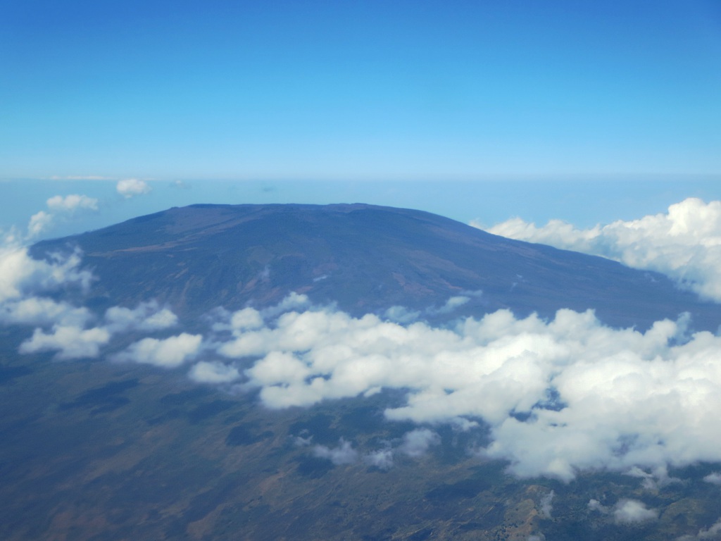
Karthala Volcano is the great adventure of the Comoros and one of the most impressive climbs in the Indian Ocean. At 2.361 metres, it is the archipelago's highest point and one of the largest active volcanoes in the world: its summit is not a sharp peak but a huge open caldera, an amphitheatre of lava and ash several kilometres wide, with one of the widest craters on the planet. Climbing to its rim and peering into the smoking abyss is an unforgettable experience.
Karthala is a very lively volcano: it has erupted more than twenty times since the 19th century, and its most recent and explosive eruptions, in 2005, 2006 and 2007, covered much of the island in ash and forced tens of thousands of people to evacuate. At the bottom of its main crater, Chahalé, a lava lake has been seen forming and solidifying. That activity is part of the appeal, and it also means you should always climb with a guide and check on the volcano's status.
This practical guide explains how to organise the climb from Moroni: when to go, how difficult it is, how to hire a guide and arrange a bivouac, what to bring and what you'll see at the summit. The trail crosses the last great highland forest on Grande Comore, with endemic birds and plants, before emerging into a lunar landscape of black lava. A tough but spectacular hike, for fit travellers keen to stand on the roof of the Comoros.
Karthala is a young, highly active shield volcano that, together with the older La Grille massif to the north, formed the island of Grande Comore. It has recorded more than twenty eruptions since 1808, with very destructive recent episodes in 2005, 2006 and 2007 that buried villages under ash. Its enormous caldera, with the Chahalé crater at its centre, is one of the widest in the world. The subject of local legends and scientific study, its geological formation and eruptive history are covered in detail on our history page.
Read the full history ↓The largest island and home of the capital: land of eleven warring sultanates, crowned by the active Karthala volcano, with Swahili Moroni and its mosques and dhows at its feet.
Read the history of Grande Comore (Ngazidja) →No exact prices: a scale from $ (budget) to $$$$$ (luxury), with 2-3 options per category.
Origins, formation and what the sources say.
The island of Grande Comore (Ngazidja) is, in essence, the work of its volcanoes. Unlike continental islands, it rose entirely from the ocean floor through the build-up of successive eruptions, in a geological process that began hundreds of thousands of years ago. Two large volcanic structures formed it: to the north, the older and more eroded La Grille massif; to the south, Karthala, much younger, active and bulkier, which today makes up most of the island and its highest point, at 2,361 metres.
Karthala is a shield volcano, with relatively gentle slopes built from flows of very fluid basaltic lava, similar to the great volcanoes of Hawaii or Réunion Island. Its most spectacular feature is the huge summit caldera, an amphitheatre several kilometres wide formed when the roof of the magma chamber collapsed after successive eruptions. Inside it lies the main crater, Chahalé, one of the widest volcanic craters in the world, where a lava lake has been seen forming on the crater floor.
Geologically, Karthala is part of a hotspot volcanism zone in the Mozambique Channel, the same one that gave rise to the entire Comoros archipelago. It is one of the most active volcanoes in the Indian Ocean and on the planet, and it is under constant scientific monitoring, since a large share of the island's population lives on its slopes or in its shadow.
Since the early 19th century, when written records began, Karthala has erupted more than twenty times, which works out to roughly one eruption per decade. Most have been effusive eruptions, with lava flows that sometimes reached the coast and even the sea, while others were explosive, releasing ash. These eruptions have repeatedly shaped the island's landscape and have forced the communities on its slopes, time and again, to live alongside the mountain's fire.
The floor of the caldera has changed shape over time: sometimes it holds a lake of glowing lava, sometimes a lake of acidic water, and at other times it is left as a field of scoria and fumaroles. In 1991, for example, a phreatic (steam) episode marked the start of a phase of activity. Each eruption reshapes the inside of the Chahalé crater, which makes Karthala a natural laboratory for volcanologists.
To keep watch over this activity, the Observatoire Volcanologique du Karthala (OVK) was set up in Moroni, tasked with monitoring the volcano's seismicity and ground deformation and alerting the population. Its work proved crucial in the 2000s, when Karthala produced its most dangerous series of eruptions in recent times.
Between 2005 and 2007, Karthala went through its most intense and destructive eruptive cycle in a long time. In April 2005 a first explosive eruption affected tens of thousands of people. But the November 2005 eruption was the most serious: a violent phreatomagmatic eruption, considered the volcano's largest in historical times, threw huge amounts of ash and volcanic material over the eastern part of the island.
That eruption left layers of ash several metres thick in some areas, contaminated the island's scarce water supplies and, in all, affected more than 200,000 people (a huge share of the island's population), forcing mass evacuations. It was a disaster for a poor country with few resources to deal with it. The following year, in May 2006, a new eruption formed a lava fountain and a lava lake inside the Chahalé crater, whose surface solidified within a few days.
In January 2007, a series of tremors and an ash cloud over the summit marked the last major episode of this cycle, with another lava lake forming in the caldera. Since then the volcano has stayed relatively calm, but it remains fully active and monitored. These recent eruptions are a reminder of Karthala's power and of why anyone planning to climb it should always check the volcano's current status first.
Karthala is not just a geographical feature: it is a constant presence in the life and imagination of Grande Comore. The name of Moroni, the capital, is said to mean 'in the heart of the fire', a reference to how close the volcano is. Its slopes hold much of the island's farming (bananas, cassava, subsistence crops and spice plantations) thanks to the fertile volcanic soils, so the same volcano that threatens the population also feeds it.
Many legends and beliefs surround the mountain. As in many cultures that live alongside volcanoes, Karthala is treated with respect and features in stories that blend Islamic faith with older traditions. The mountain, its forests and its springs are part of the memory and identity of the people of Ngazidja.
Ecologically, Karthala's slopes are home to the island's last large area of high-altitude rainforest, a refuge for endemic species of birds and plants that are now threatened by deforestation. Protecting that forest is key both for biodiversity and for the island's water cycle. The volcano is therefore at once a threat, a livelihood, a natural sanctuary and a symbol of Grande Comore.
For travellers, Karthala is today the great adventure of the Comoros and one of the few active volcanoes in the world whose giant crater you can visit on a hike. Trails start from the highland villages on its slopes and, after hours of climbing through the forest and then across lava fields, lead to the rim of the caldera. Looking out from there, seeing the fumaroles and taking in the island and the sea from the roof of the archipelago is an experience that more than makes up for the effort.
The classic way to do it is over two days, with a night camping near the summit to watch the sunrise over the crater, always with a local guide who knows the route and the volcano's current state. It is a demanding hike that calls for good fitness, proper gear and respect for the mountain, but it is also one of the most unusual trekking experiences in the Indian Ocean.
Tourism around Karthala is still modest, which gives it a feel of genuine exploration: few hikers, untouched nature and mountain communities that welcome visitors warmly. Together with the Swahili medinas recently declared World Heritage and the archipelago's beaches, the climb up Karthala is one of the best reasons to discover this little-known corner of Africa, where the Earth's fire is still shaping the landscape.