Nicosia is a city like no other in Europe: the continent's last divided capital. A line of barbed wire, rusty oil drums, sandbags and abandoned houses — the Green Line, patrolled by UN blue helmets since 1974 — cuts through its heart and separates two worlds. To the south, the Republic of Cyprus, a member of the European Union, with its cafés, its boutiques and the euro. To the north, the Turkish Cypriot administration, with its mosques, its markets and the Turkish lira. Walking from one side to the other along Ledra Street is one of the most intense and eye-opening travel experiences the Mediterranean has to offer.
But reducing Nicosia to its division would be unfair. Inside its perfect Venetian walls, shaped like an eleven-pointed star, beats an ancient city that has been the capital of Cyprus for more than a thousand years. Here Gothic cathedrals turned into mosques sit alongside Byzantine churches, Ottoman caravanserais, first-rate museums — the Cyprus Museum holds treasures from nine thousand years of history — and an old town that has been coming back to life with workshops, bars and restaurants. It is a small, human and surprisingly lively capital.
This guide explores Nicosia with a practical, warm eye: how to cross the Green Line, what to see on each side, where the big museums are, how to get around, where to sleep and eat, and how to understand — soberly and without taking sides — the history that left this city split in two. Nicosia is not your usual tourist postcard: it is a place that makes you think, and that is exactly why it is so worthwhile.
Inhabited since the Bronze Age and known in antiquity as Ledra, Nicosia became the capital of Cyprus in Byzantine times and reached its height under the Frankish Lusignans (12th-15th centuries), who filled it with Gothic churches, and under Venice, which in the 16th century surrounded it with its famous star-shaped walls. In 1570 it fell to the Ottomans, who turned cathedrals into mosques and ruled for three centuries, until in 1878 Cyprus came under British administration. After independence in 1960, tensions between the Greek and Turkish communities led to the Turkish invasion of 1974, which divided the city and the island along the Green Line, a situation that persists today. This whole story, told in detail and with restraint, is on our history page.
Read the full history ↓The heart of the island: the last divided capital in Europe, with its star-shaped Venetian walls and the Green Line crossing Ledra Street, and the Troodos Mountains, a refuge of copper, monasteries and painted Byzantine churches.
Read the history of Nicosia and the centre →They depart from Larnaca, 37 km away. If you book from this link we earn a commission and you pay no more.
No exact prices: a scale from $ (budget) to $$$$$ (luxury), with 2-3 options per category.
Origins, formation and what the sources say.
Nicosia is a very old city that, unlike almost every other Cypriot capital, does not sit by the sea. It stands in the middle of the island, on the fertile Mesaoria plain, between the two mountain ranges that shape Cyprus: the Troodos massif to the southwest and the Pentadaktylos (Kyrenia) range to the north. That central position, sheltered from the pirate raids that ravaged the coast, was the key to its destiny.
In antiquity this was the site of one of the city-kingdoms of Cyprus, called Ledra or Ledroi, already mentioned in Assyrian sources from the 7th century BC. It was a modest settlement compared with the great coastal kingdoms such as Salamis or Kition, but it survived while they went into decline. The ancient name lives on today in Ledra Street, the main artery of the old town.
With the fall of the ancient world and the Arab raids that, from the 7th century onwards, repeatedly devastated the coastal cities of Cyprus, people began to seek refuge inland. Nicosia, safe in the interior, steadily gained importance until, around the 10th-11th century, it became the capital of Byzantine Cyprus, a status it would never lose. The city then took on the shape that would define it for centuries: a political and religious centre in the heart of the island.
Nicosia's great leap forward came in the Middle Ages. In 1191, during the Third Crusade, King Richard the Lionheart conquered Cyprus and shortly afterwards sold it to Guy de Lusignan, a Frankish nobleman. So began the Lusignan Kingdom of Cyprus, a French-style feudal monarchy that ruled the island for almost three centuries (1192-1489) and made Nicosia its capital and one of the richest, most refined courts in the eastern Mediterranean.
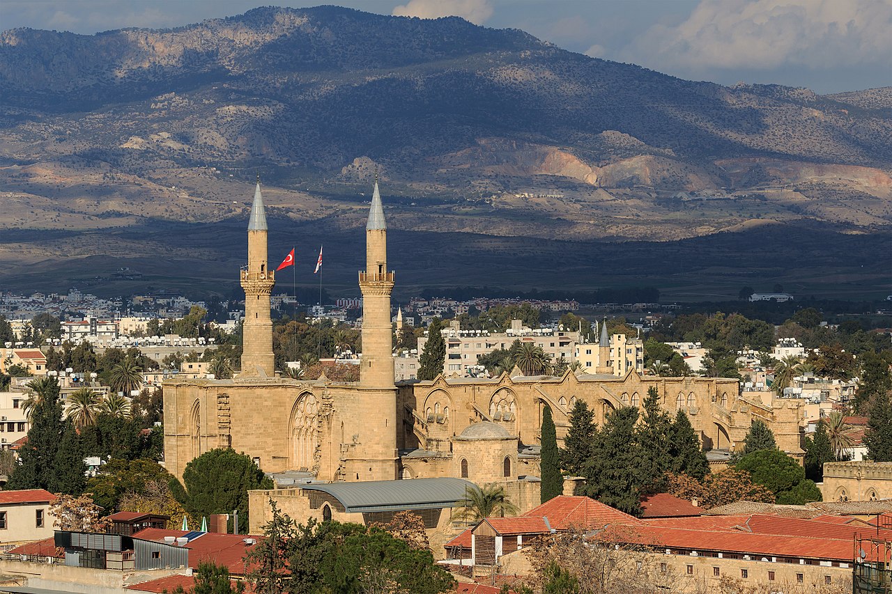
The Lusignans filled the city with Gothic architecture brought over from France. The masterpiece was the Cathedral of Saint Sophia, begun in the late 13th century and consecrated in 1326: a genuine French Gothic cathedral, with flying buttresses and pointed arches, now the Selimiye Mosque. They also built the Church of Saint Nicholas, palaces, monasteries and the homes of an aristocracy that lived in luxury while most of the Greek Orthodox population was kept in subjection as peasants.
It was a time of splendour but also of tension: the conquerors' Latin Catholic Church pushed aside the Greek Orthodox hierarchy, and society was split between a Frankish elite and a Greek majority. In 1489 the kingdom passed to the Republic of Venice, when the last queen, Catherine Cornaro, Venetian by birth, handed the island over to her home city.
Under Venetian rule (1489-1571), Nicosia remained the capital, but the threat from the growing Ottoman Empire forced a rethink of its defences. The old medieval wall, sprawling and outdated, could not withstand modern artillery. Between 1567 and 1570, Venetian engineers tore down the old circuit and built a new, more compact one: the star-shaped wall with eleven bastions that still surrounds the old town today. It was one of the most advanced fortifications of its time, designed for warfare with cannons. To build it, churches, palaces and entire neighbourhoods lying outside the new perimeter were demolished.
It did little good. In July 1570 the Ottoman army laid siege to the city. After several weeks of siege, Nicosia fell on 9 September 1570. The capture was extremely violent: sources describe the massacre of a large part of the population and the sacking of the city. The defenders' heads were sent as a warning to Famagusta, which would hold out until 1571. With the fall of Nicosia and then Famagusta, all of Cyprus came under Ottoman rule.
The Ottomans turned the Cathedral of Saint Sophia into a mosque, adding the two minarets that define it today, and did the same with other churches. They built caravanserais such as the Büyük Han, Turkish baths and fountains. The city took on an Ottoman look that it partly keeps, especially in what is now the northern sector.
During three centuries of Ottoman rule (1571-1878), Nicosia was the seat of the island's governor. The social make-up changed: alongside the Greek Orthodox majority, a Muslim Turkish Cypriot population settled, and the two communities lived side by side in the city, often in separate neighbourhoods around their churches and mosques. The Greek Orthodox Church, which the Ottomans recognised as the representative of the Christian community under the millet system, regained prominence, and the Archbishop of Cyprus became a political as well as a religious figure.
In 1878, amid Ottoman decline and the European agreements that followed the Russo-Turkish War, the Ottoman Empire handed the administration of Cyprus to the United Kingdom, although formal sovereignty remained nominally Ottoman until 1914, when Britain annexed the island on going to war with the Ottoman Empire. Cyprus became a Crown colony in 1925.
Under the British, Nicosia grew beyond its walls: new neighbourhoods, avenues and administrative buildings were laid out, and the city modernised. But nationalism grew too. Among the Greek Cypriot majority, the aspiration to enosis, union with Greece, spread, while the Turkish Cypriot minority feared being dominated and backed other options. In the 1950s the EOKA organisation launched an armed struggle against British rule. Nicosia saw bombings, riots and growing intercommunal violence. In 1960 Cyprus finally gained independence as a republic, with Nicosia as its capital.
The young Republic of Cyprus, with its complex power-sharing constitution between Greek Cypriots and Turkish Cypriots, soon fell into crisis. In December 1963 violent intercommunal clashes broke out in Nicosia. To separate the two sides, a British officer drew a line on a map of the city with a green pencil: hence the name 'Green Line', which ever since has referred to the border dividing the city and, later, the whole island. In 1964 a United Nations peacekeeping force (UNFICYP) was deployed, and it is still there.
The final crisis came in 1974. In July, the Greek Cypriot National Guard, backed by the military dictatorship then ruling Greece, staged a coup to force union with Greece. In response, Turkey invaded the north of the island in two waves, occupying about 37 % of the territory. The war caused huge population displacement in both directions: Greek Cypriots in the north fled south and Turkish Cypriots in the south fled north, leaving entire villages and neighbourhoods empty. Nicosia was split for good by the Green Line, with the UN buffer zone running through its old town.
This is a painful and still unresolved subject, with accounts and responsibilities that each community experiences differently. It is best approached soberly: there were victims, missing persons and displaced people on both sides, and the wounds are still there. Along the Green Line, the city still has bricked-up houses, blocked streets and buildings frozen in 1974.
Half a century later, Nicosia is still Europe's last divided capital. In the south, the Republic of Cyprus has been a member state of the European Union since 2004 and adopted the euro in 2008. In the north, the self-proclaimed 'Turkish Republic of Northern Cyprus', declared in 1983, is recognised only by Turkey; for the international community and the UN, that territory remains part of the Republic of Cyprus under occupation. The buffer zone patrolled by the blue helmets runs across the country and its capital.
In 2003 crossing restrictions were eased for the first time, and in April 2008 the Ledra Street pedestrian crossing opened, right in the old town, used every day by tourists and residents alike. Crossing from one side to the other — showing your passport, with no stamp — has become an everyday act, although political reunification remains stalled despite numerous rounds of UN-sponsored negotiations.
Beyond the conflict, Nicosia today is a lively capital in transformation. The old town in the south has been reborn with bars, chef-driven restaurants, galleries and workshops, especially in the streets near the Green Line. It is home to the university, the government and the banks, and it is a young, cosmopolitan city. Walking through it means looking at once at nine thousand years of history and at one of the most unusual frozen borders in the world: an experience no other European capital can offer.