Viajá con Gus
HomeChileSantiago
Santiago
🇨🇱 Chile · Central Chile and Santiago

Santiago

Jump to what you need
📍Region
Santiago is the capital of Chile and sits in the Santiago Metropolitan Region, in the middle of the country's central valley, some 520 meters above sea level. It is the political, economic and cultural heart of Chile and, by far, its most populous city: the metropolitan area (Greater Santiago) is home to more than 7 million people, close to a third of the whole Chilean population. The city spreads across a basin ringed by mountains, with the towering Andes and their snow-capped peaks as a backdrop to the east, and the Coastal Range to the west. The Mapocho river crosses it from the mountains westward.
📌Service city
Santiago itself has everything. Its gateway is Arturo Merino Benítez International Airport (SCL), in the district of Pudahuel, some 15-20 km from the center, which handles almost all of the country's international and domestic flights. The city has one of the best metro networks in South America, a bus system (Red, formerly Transantiago), intercity bus terminals (Terminal Sur, Alameda, Pajaritos) and a huge choice of hotels, hospitals, ATMs and tourist offices (Sernatur). It's the natural base for exploring the central valley, the Maipo and Casablanca wine valleys, the Andean ski resorts, and for connecting to Valparaíso and Viña del Mar (a little over an hour and a half away).
📌Best time to go
Santiago has a Mediterranean climate, with four clearly marked seasons. Spring (September to November) and autumn (March to May) are usually the best times to visit: pleasant temperatures, sunny days and no extreme heat. Summer (December to February) is dry and very hot, with days comfortably above 30 °C, though the nights cool off; it's a good season for pools, terraces and for climbing the hills early. Winter (June to August) is cool and, down in the basin, can suffer smoggy days because of thermal inversion, but it's ski season at the nearby Andean resorts (Valle Nevado, Farellones, La Parva) and gives you the cordillera fully covered in snow as a backdrop.
📌Suggested days
Two or three days cover the essentials of the city: the historic center with the Plaza de Armas, the Cathedral and the Palacio de La Moneda, Cerro Santa Lucía, Cerro San Cristóbal with its funicular and the Parque Metropolitano, the Bellavista and Lastarria neighborhoods, the Mercado Central and the view from Sky Costanera, in the Gran Torre Santiago. With 4 to 5 days you can add the great museums (Museo Chileno de Arte Precolombino, Museo de la Memoria y los Derechos Humanos), the Cementerio General, more neighborhoods and nightlife, and at least one full-day excursion: a winery in the Maipo Valley, the Cajón del Maipo up in the mountains, or a getaway to Valparaíso and Viña del Mar.
📌Language / Currency
Spanish / Chilean peso (CLP). Chilean Spanish is spoken, with its distinctive accent and slang; in tourist areas and hotels there is usually staff who speak English. The currency is the Chilean peso; it's worth carrying some cash for markets, street fairs and tips, though cards are widely accepted and there are ATMs all over the city.
💱 CLP exchange rate
Loading rate…
🌤️ Weather in Santiago
Loading weather…

Santiago de Chile is one of those capitals that surprises anyone who arrives with low expectations. Hemmed into a valley at the foot of the Andes, the city offers a postcard that's hard to match: glass skyscrapers cut against snow-covered peaks, wide tree-lined avenues, island hills rising between the neighborhoods and a sky that, on clear days, hands back all the majesty of the Andes. It's a modern, orderly, thriving metropolis that nonetheless keeps colonial corners, squares with history and a warm, thoroughly enjoyable neighborhood life.

Santiago is contrast. It's the historic center around the Plaza de Armas, with the Cathedral and the Palacio de La Moneda; it's the bohemia of Bellavista at the foot of Cerro San Cristóbal, with its murals, bars and Pablo Neruda's house; it's the heritage and cultural charm of the Lastarria neighborhood; it's the bustle and the smells of the Mercado Central and La Vega; and it's also modern Santiago in Providencia, Las Condes and the financial district nicknamed 'Sanhattan', crowned by the Gran Torre, the tallest skyscraper in South America. All of it coexists with a booming food scene and with wine culture, which has some of the world's most acclaimed wineries in the nearby valleys.

This guide covers the essentials of Santiago with a practical, warm eye: which hills to climb to have the city at your feet, which museums and neighborhoods not to miss, how to get around on one of the region's best metro systems, where to eat and drink good wine, and which day trips are worth it (from the Maipo wineries to the Cajón del Maipo, by way of Valparaíso). Santiago is the ideal launching point for seeing Chile, but it's also a city that deserves days of its own and that rewards a little planning.

📖 History of Santiago

Long before the Spanish arrived, the valley of the Mapocho river was inhabited by Picunche communities, farmers who spoke Mapudungun, and the influence of the Inca Empire had reached this far in its expansion southward. The city was founded by the Spanish conquistador Pedro de Valdivia on 12 February 1541, under the name Santiago del Nuevo Extremo, on a strategic site between two arms of the Mapocho, beside the hill of Huelén, which the Spanish renamed Santa Lucía. A few months later, in September 1541, an Indigenous uprising led by the chief Michimalonco almost completely destroyed the newborn city, which was rebuilt with enormous effort, in large part thanks to Inés de Suárez. During the colonial era, Santiago grew slowly as the administrative center of the Captaincy General of Chile, shaped by earthquakes and by the flooding of the Mapocho. In 1810 it was the cradle of the independence movement, and after independence it consolidated as the capital of the Republic. The 19th century and the early 20th transformed it: the railway arrived, along with grand public buildings, parks and the channeling of the Mapocho. In the 20th century it saw strong growth and modernization, but also the most painful episode in its history: the coup d'état of 11 September 1973, with the bombing of La Moneda, the death of President Salvador Allende and the dictatorship of Augusto Pinochet, remembered today at the Museo de la Memoria. With the return of democracy in 1990, Santiago became the modern, vertical, cosmopolitan metropolis it is today. The full story is on our history page.

Read the full history ↓

🏛️ Santiago Metropolitan Region

The political and economic heart of Chile: Santiago, founded in 1541 at the foot of the Andes, with the La Moneda palace and the canalised Mapocho River; pottery villages such as Pomaire; the mountain country of the Cajón del Maipo; and the world-class ski resorts of the Tres Valles.

Read the history of Santiago Metropolitan Region →

🗺️ What to see

1
Cerro San Cristóbal and Parque Metropolitano
Santiago's great green lung, crowned by the statue of the Virgin, with a funicular, viewpoints and views over the whole city and the Andes.
Cerro San Cristóbal is Santiago's viewpoint par excellence and the heart of the Parque Metropolitano, one of the largest urban parks in the world, with nearly 740 hectares of green space spread over several of the city's hills. Its main summit, around 880 meters above sea level (about 300 meters above the city), is crowned by a great white statue of the Virgin of the Immaculate Conception, visible from much of Santiago and now one of its symbols. The most classic and charming way up is the Cerro San Cristóbal funicular, opened in 1925 and declared a Historic Monument, which sets off from the Pío Nono entrance, right in Bellavista, and climbs the slope to the top. You can also go up on foot or by bicycle along the park's roads, and there is a cable car connecting different sectors. From the summit, on a clear day, you get a 360-degree panorama over all of Santiago, with the snow-covered Andes behind: the best way to understand the city's geography. The park offers far more than the view: inside it are the National Zoo, the Mapulemu Botanical Garden, the Tupahue and Antilén swimming pools (for summer), viewpoints, trails for walking or running, and corners for a picnic. It's an ideal plan both for starting the day with a panoramic view and for spending an afternoon outdoors with the family. Getting there: the Pío Nono entrance (with the funicular) is steps from Baquedano metro station, in the Bellavista neighborhood. Best time: go on a clear day, ideally in the morning, when the cordillera looks cleanest and there's less smog. Tips: bring water, sunscreen and comfortable shoes; combine it with a walk around Bellavista at the foot of the hill.
ℹ️ Location: Bellavista neighborhood; funicular from Pío Nono (Baquedano metro) · Best time: A clear day, in the morning (cleaner cordillera, less smog) · Admission: Free access to the park; funicular round trip approx. $3,650 (weekdays) to $4,380 CLP (weekends); cable car from ~$1,850 CLP (source: Parquemet / Teleférico Santiago, verified July 2026; worth confirming at parquemet.cl) · Duration: Half a day
2
Cerro Santa Lucía
The historic hill in the middle of downtown where Santiago was founded, today a romantic park of terraces, fountains and lookouts.
Cerro Santa Lucía is a small island hill some 69 meters high right in the center of Santiago, loaded with history and charm. To the Indigenous peoples it was Huelén ('pain' or 'melancholy' in Mapudungun), and it was precisely at its foot that Pedro de Valdivia founded the city in 1541. For centuries it was a bare rocky outcrop, until in the late 19th century the city governor Benjamín Vicuña Mackenna turned it into one of the loveliest promenades in the city. Vicuña Mackenna had terraces, stone stairways, fountains, lookouts, gardens and monuments built, turning the hill into a romantic park in neoclassical style, opened in 1874. Today you climb by paths and stairs through the greenery, passing corners such as the Terraza Neptuno (with its fountain and monumental staircase), the Plaza Pedro de Valdivia and, at the top, a lookout with views over the historic center and the cordillera. The main entrance, on the Alameda, is flanked by the Fountain of Neptune. It's a green oasis in the middle of the downtown bustle, ideal for a quiet walk, taking photos and resting in the shade. Right around it are the Museo de Bellas Artes (through the Lastarria neighborhood), the Centro Gabriela Mistral (GAM) and the National Library, which makes it easy to put together a cultural walking route. Getting there: it's steps from Santa Lucía metro station, on the Alameda (Av. Libertador Bernardo O'Higgins). Best time: daytime, with good light; ideal in the morning or at dusk. Tips: entry is usually free (sometimes they ask you to sign in at the gate); wear comfortable shoes for the stairs and combine it with the Lastarria neighborhood, which is right next door.
ℹ️ Location: Historic center, on the Alameda (Santa Lucía metro) · Best time: Daytime; morning or dusk for the light · Admission: Free (open access; sometimes sign-in at the gate) · Duration: 1 to 2 hours
3
Plaza de Armas and the Metropolitan Cathedral
Santiago's founding heart, ringed by the Cathedral, the Central Post Office and the colonial buildings of power.
The Plaza de Armas is Santiago's ground zero: the place where Pedro de Valdivia laid out the city in 1541, following the classic Spanish grid, and the historical, social and symbolic heart of the capital ever since. For centuries it was the center of colonial and republican power, the setting for markets, executions, celebrations and daily life. Today it's a lively square, with palm trees, benches, chess players, street performers, shoe-shiners and people from everywhere, ringed by some of the most important buildings in the country. The most imposing of them is the Metropolitan Cathedral of Santiago, the fifth raised on the same site (the earlier ones were destroyed by earthquakes and fires). The present one, neoclassical with baroque details, dates from the late 18th century and was worked on by the Italian architect Joaquín Toesca; its wide, luminous interior holds altars, chapels and works of sacred art. Beside the Cathedral stands the Archbishop's Palace. Facing the square are other gems: the Palacio de la Real Audiencia (today the National History Museum), which runs through the history of Chile from the conquest onward; the Central Post Office building, on the plot where Valdivia's house once stood; and the Santiago city hall. The whole ensemble is a declared Zona Típica and a Historic Monument. Getting there: it sits above Plaza de Armas metro station, right downtown. Best time: daytime, when the square is liveliest and the museums are open. Safety tips: it's a very busy, touristy area, so watch your belongings and your phone, especially at peak hours. Combine it with a walk through the historic center as far as La Moneda.
ℹ️ Location: Historic center (Plaza de Armas metro) · Best time: Daytime, with the square lively and the museums open · Admission: Square and Cathedral free to enter; National History Museum has free general admission (verified July 2026) · Duration: 1 to 2 hours (more if you go into the museum)
4
Palacio de La Moneda
The seat of Chile's government, a neoclassical jewel and the scene of the 1973 bombing, with an underground cultural center.
The Palacio de La Moneda is the seat of the Presidency of the Republic of Chile and one of the country's most emblematic buildings. It's a masterpiece of colonial neoclassical architecture, designed by the Italian architect Joaquín Toesca in the late 18th century. It was originally built to house the Mint (hence its name), where gold and silver coins were struck; only in the mid-19th century did it become the government palace and presidential residence. La Moneda was marked forever by the coup d'état of 11 September 1973, when it was bombed from the air during the overthrow of President Salvador Allende, who died that day inside the palace. Restored after the dictatorship, it is once again the center of executive power. You can walk its inner courtyards (the Patio de los Naranjos and the Patio de los Cañones) on visits, and watch the ceremonial changing of the guard, held every other day with the presidential band and escort. Beneath the esplanade of the Plaza de la Ciudadanía, in front of the palace, is the Centro Cultural La Moneda, a modern underground space with art exhibition halls, a film archive, and design and craft shops. The square itself, with its giant Chilean flag, is a meeting point and a stage for civic demonstrations. Getting there: it sits above La Moneda and Universidad de Chile metro stations, a few blocks from the Plaza de Armas through the civic center. Best time: daytime; check the times of the changing of the guard and of the cultural center. Tips: touring the inner courtyards usually requires signing up beforehand; check the current conditions and hours. Combine it with a walk through the historic center.
ℹ️ Location: Civic center (La Moneda / Universidad de Chile metro) · Best time: Daytime; check the changing-of-the-guard schedule · Admission: Square and courtyards free to enter (courtyard visits may require signing up); Centro Cultural La Moneda: exhibition halls approx. $3,000–6,000 CLP (verified July 2026) · Duration: 1 to 2 hours (more with the cultural center)
5
Bellavista neighborhood
Santiago's bohemian quarter at the foot of Cerro San Cristóbal, with murals, bars, nightlife and Pablo Neruda's house.
Bellavista is Santiago's bohemian, artistic quarter par excellence, stretched between the Mapocho river and the flanks of Cerro San Cristóbal, straddling the districts of Recoleta and Providencia. It's a neighborhood of low, colorful houses, tree-lined streets, murals and graffiti, artists' studios, restaurants, bars and clubs that by night make it one of the epicenters of Santiago's scene. By day it has a quieter charm, ideal for a stroll. Its great cultural jewel is La Chascona, one of the three house-museums of the poet Pablo Neruda (along with La Sebastiana in Valparaíso and the house at Isla Negra). Neruda built it in the 1950s for his then lover and future wife Matilde Urrutia, and named it after her untameable mane ('chascona' means 'tousled'). It's a labyrinthine, playful house, full of objects, collections and eccentric corners, reflecting the personality of the Nobel laureate; today it's a museum of the Neruda Foundation and can be visited with an audio guide. Bellavista also has Patio Bellavista, a pedestrian complex with restaurants, design and craft shops (lapis lazuli, jewelry, leather) very popular with tourists, and the Cerro San Cristóbal funicular sets off from the neighborhood along Pío Nono street. Walking it means discovering striking murals and the city's creative life. Getting there: steps from Baquedano metro station, across the Mapocho. Best time: daytime for strolling and visiting La Chascona; at night (Thursday to Saturday) for going out, with the usual precautions of any party district. Safety tips: at night carry little on you, watch your phone and go back by taxi or app. Combine it with the climb up Cerro San Cristóbal, which starts here.
ℹ️ Location: Between Providencia and Recoleta, at the foot of Cerro San Cristóbal (Baquedano metro) · Best time: Daytime for strolling and La Chascona; Thursday to Saturday at night for the scene · Admission: Walking the neighborhood is free; La Chascona approx. $7,000–8,000 CLP general, $2,500 students/seniors (verified July 2026, audio guide included). Check when visiting · Duration: Half a day (more with nightlife)
6
Lastarria neighborhood
Santiago's chicest and most cultural quarter, with cobbled streets, cafés, museums, bookshops and terrace life.
The Lastarria neighborhood is one of the most charming and culturally alive corners of Santiago, set between Cerro Santa Lucía and the Parque Forestal, beside the Mapocho river. It's a heritage quarter of cobbled streets and early-20th-century buildings that in recent decades has turned into a hub of food, art and design, full of cafés with tables on the sidewalk, restaurants, bookshops, galleries, boutique hotels and independent stores. Its heart is José Victorino Lastarria street and the Plaza Mulato Gil de Castro. The neighborhood concentrates a remarkable cultural offering. Here are the Museo de Artes Visuales (MAVI), the Museo Arqueológico de Santiago, the Gabriela Mistral cultural center (GAM) — an imposing building with theaters, halls and public spaces on the Alameda — and, steps away, the Museo Nacional de Bellas Artes, in the Parque Forestal, with its beautiful French-inspired façade. On weekends there are usually antiques and book fairs in Plaza Mulato Gil. Lastarria is ideal for getting lost on foot, sitting on a terrace over a coffee or a glass of wine, and soaking up the most cosmopolitan and relaxed side of Santiago. The Parque Forestal, which borders it, is a long tree-lined park along the Mapocho, perfect for walking or cycling. Getting there: steps from Universidad Católica or Bellas Artes metro stations, beside Cerro Santa Lucía. Best time: any day; it comes alive at dusk with the terraces. Tips: combine it with Cerro Santa Lucía and the Museo de Bellas Artes on the same walking route. It's one of the best neighborhoods for eating and staying downtown.
ℹ️ Location: Between Cerro Santa Lucía and the Parque Forestal (Bellas Artes / Universidad Católica metro) · Best time: Any day; at dusk for the terraces · Admission: Free to walk around; Museo de Bellas Artes has free general admission; MAVI approx. $2,000–3,000 CLP (verified July 2026) · Duration: Half a day
7
Mercado Central
Santiago's historic fish and seafood market, with its ironwork structure and classic restaurants.
Santiago's Mercado Central is one of the tastiest and most traditional visits in the city, and unmissable for anyone who loves food. Opened in 1872, it occupies a handsome building whose metal structure was manufactured in England and assembled in Santiago, with an elegant iron roof covering the stalls. It is, above all, the capital's great fish and seafood market: its stalls display the enormous wealth of the Chilean sea, with conger eel, reineta, hake, razor clams, abalone, sea urchins, mussels, king crab and much more. Around the sales stalls there are numerous kitchens and restaurants, from the showiest and most touristy ones in the middle of the market to the simpler, much-loved local spots in the side aisles. This is the place to try the classics of Chilean seafood cooking: a fisherman's soup, a caldillo de congrio (the dish Neruda immortalized in an ode), a curanto, ceviche, machas a la parmesana or fried fish. Very close by, across the Mapocho river, is the Mercado La Vega Central (or La Vega), Santiago's great fruit, vegetable and grocery market, far more working-class and chaotic, where you can feel the everyday life of the city and eat very well for very little. Doing both in one morning is an authentic experience. Getting there: steps from Puente Cal y Canto metro station, beside the Mapocho. Best time: midday, for lunch; go in the morning to see it in full swing. Tips: the restaurants in the middle can push hard to pull you to a table; check prices and, if you want something more authentic and cheaper, head for the smaller places on the sides or cross over to La Vega. Watch your belongings in the crush.
ℹ️ Location: Downtown, beside the Mapocho (Puente Cal y Canto metro) · Best time: Midday for lunch; morning to see it in action · Admission: Free (open access); you pay for what you eat · Duration: 1 to 2 hours (with lunch)
8
Gran Torre Santiago and Sky Costanera
The tallest skyscraper in South America, with a viewing deck 300 meters up and 360° views over the city and the Andes.
The Gran Torre Santiago is the tallest skyscraper in South America, some 300 meters high with 62 floors, designed by the celebrated Argentine architect César Pelli. It forms part of the Costanera Center complex, in the heart of Providencia's financial district (nicknamed 'Sanhattan' for its skyline), and also includes a large shopping mall. It's one of the great icons of modern, vertical Santiago. On the upper floors is Sky Costanera, the highest viewing deck on the continent, a panoramic observatory occupying floors 61 and 62. From there, some 300 meters up, you get an utterly spectacular 360-degree view over the whole city of Santiago, which stretches to the horizon, with the snow-covered Andes on one side and the Coastal Range on the other. There are enclosed sections with floor-to-ceiling windows and an open-air terrace. It's the ideal place to grasp the size of Santiago and its geography of a basin ringed by mountains. Choose your time well: going on a clear day is key for the cordillera to show cleanly, and dusk is the most magical moment, as the city shifts from gold to night lights. Getting there: above Tobalaba or Los Leones metro stations, in Providencia, inside the Costanera Center. Best time: a clear day (cleaner cordillera); dusk is the best moment. Tips: it's worth buying your ticket in advance and checking the forecast to avoid days of heavy smog or cloud, which block the view.
ℹ️ Location: Costanera Center, Providencia (Tobalaba / Los Leones metro) · Best time: A clear day; dusk to watch the city light up · Admission: Official rate (Sky Costanera website): adults $25,000 CLP (daytime) / $30,000 CLP (sunset, 16:00–18:00); children 5–12 $10,000 CLP; 0–4 free. Aggregators and advance sales often show lower promotional rates (from ~$8,000 for adults, depending on the channel). Open 10:00–22:00 (source: skycostanera.cl, verified July 2026) · Duration: 1 to 2 hours
9
Museo de la Memoria y los Derechos Humanos
The museum devoted to the human rights violations of the dictatorship (1973-1990), moving and essential.
The Museo de la Memoria y los Derechos Humanos is one of the most important and most moving spaces in Santiago, devoted to making known the human rights violations committed by Augusto Pinochet's military dictatorship between the 1973 coup and the return to democracy in 1990. Opened in 2010, it occupies a modern, austere building in the Quinta Normal area, whose architecture — suspended and clad in oxidized copper — seeks to convey the weight of memory. Through photographs, documents, letters, objects, audiovisual material and testimony, the museum reconstructs what happened: the bombing of La Moneda and the death of President Salvador Allende, the repression, the arrests, the torture, the clandestine centers, the disappeared and executed, the exile, but also the resistance, the international solidarity and the struggle for truth and justice. It's an intense, emotional visit, put together with respect and rigor, that helps you understand a central chapter of Chile's recent history and the universal importance of human rights. The route is largely self-guided and general admission is free, which makes it very accessible. It's a recommended visit for any traveler who wants to understand today's Chile, though it's worth going with time and the right frame of mind, because the content is hard. Getting there: steps from Quinta Normal metro station. Best time: any day (it usually closes on Mondays; check hours). Tips: take your time; audio guides are available. Given its location, it can be combined with Parque Quinta Normal and its museums (Museo Nacional de Historia Natural, MAC, etc.).
ℹ️ Location: Quinta Normal area (Quinta Normal metro) · Best time: Any day; usually closed Mondays (check) · Admission: Free (general admission waived); optional audio guide approx. $2,000 CLP (verified July 2026) · Duration: 2 to 3 hours
10
Museo Chileno de Arte Precolombino
One of the finest pre-Columbian art museums in the Americas, with pieces from the continent's Indigenous cultures.
The Museo Chileno de Arte Precolombino is considered one of the best museums of its kind in Latin America and an essential visit for understanding the continent's Indigenous cultures. It sits right in the historic center, in the old and elegant Palacio de la Real Aduana, a handsome late-18th-century colonial building, a few steps from the Plaza de Armas. Its collection, originally assembled by the architect and collector Sergio Larraín García-Moreno, spans close to three thousand years of history and brings together pieces of the highest artistic and archaeological value from Mesoamerica, the Intermediate Area, the central Andes and southern South America. Ceramics, textiles, goldwork, sculptures, masks and ritual objects from cultures such as the Maya, Mexica, Nazca, Moche, Tiwanaku, Inca, Mapuche and many others are displayed with careful, informative museography. One of its outstanding rooms is Chile Before Chile, devoted to the Indigenous peoples of present-day Chilean territory. It's a museum of manageable size, perfect for combining with a walk through the historic center, and it lets you appreciate the enormous diversity and sophistication of the American cultures before the Europeans arrived. Getting there: steps from Plaza de Armas metro station, right downtown. Best time: any day (it usually closes on Mondays; check). Tips: combine it with the Plaza de Armas, the Cathedral and the National History Museum, all very close by. Chileans and residents pay a reduced rate; foreigners pay the general one.
ℹ️ Location: Historic center, beside the Plaza de Armas (Plaza de Armas metro) · Best time: Any day; usually closed Mondays (check) · Admission: Non-resident foreigners $7,000 general / $2,000 students; Chileans and resident foreigners $1,000 / $500; under-10s free and free on the first Sunday of the month. Open Tuesday to Sunday 10:00–18:00 (source: museo.precolombino.cl, verified July 2026) · Duration: 1 to 2 hours
11
Cementerio General
One of the largest cemeteries in the Americas, an open-air museum of monumental mausoleums and the history of Chile.
Santiago's Cementerio General is far more than a burial ground: it's a genuine open-air museum and one of the largest and most remarkable cemeteries in Latin America. Founded in 1821, in the first years of independence, it sprawls over an enormous area in the district of Recoleta, laid out like a miniature city, with avenues, streets, tree-lined squares and thousands of mausoleums, chapels and funerary monuments of great architectural and artistic value. Walking it is a run through much of the history of Chile: most of the country's presidents rest here, along with national figures, artists, writers and intellectuals. Among the most visited graves is that of President Salvador Allende, and the Memorial to the Detained-Disappeared and the Politically Executed, an imposing wall dedicated to the victims of the dictatorship, which also makes the cemetery a space of memory. There is everything from the sumptuous mausoleums of wealthy 19th-century families to the simple and much-loved shrine of Romualdito, a focus of popular devotion. The architecture is fascinatingly varied, with neoclassical, Egyptian, Gothic and modernist styles, surrounded by century-old trees. There are guided tours (including night and heritage tours) that help you uncover its stories, legends and characters. Getting there: steps from Cementerios metro station (line 2), in Recoleta. Best time: daytime, with good light; ideally on a guided tour. Tips: it's enormous, so a map or a tour helps you avoid getting lost and makes the most of the stories. Combine it with the Recoleta neighborhood and the Mercado La Vega, relatively close by.
ℹ️ Location: Recoleta (Cementerios metro, line 2) · Best time: Daytime; ideally on a guided tour · Admission: Free access; heritage guided tours approx. $5,000–12,000 CLP per person (verified July 2026). Check when visiting · Duration: 1 to 2 hours (more with a guided tour)
12
Maipo Valley wineries (day trip)
The wineries closest to Santiago, cradle of the great Chilean Cabernet Sauvignon, ideal for a one-day wine tour.
The Maipo Valley is the wine region closest to Santiago and one of the most prestigious in Chile, especially famous for its reds: some of the finest Cabernet Sauvignons in the country and the world are made here. It spreads around the capital, with the Alto Maipo (on the mountain flanks southeast of the city) as its most renowned sector, where altitude, climate and soils give wines of great structure and elegance. It's the easiest wine excursion to do in a day from Santiago. Several of the most historic and best-known wineries in Chile lie a short distance from the city and receive visitors with guided tours of their vineyards and cellars, tastings of their wines, restaurants and, in some cases, beautiful parks and century-old manor houses. Visits usually include a walk through the winemaking process, the barrel cellars and a tasting commented by an expert, a wonderful way to learn about Chilean wine while enjoying the landscape with the cordillera behind. You can go on your own (several wineries are well connected) or, better still, on an organized tour from Santiago that includes transport, which lets you taste at ease. Some tours combine two or three wineries in a day. Getting there: on an organized tour from Santiago, by taxi/app or, depending on the winery, by public transport. Best time: year-round; the harvest (March-April) has a special charm. Tips: book your visit in advance, bring your ID or passport if you're going to taste (over-18s only) and if you're driving, appoint someone who won't drink.
ℹ️ Location: Maipo Valley, around Santiago (Alto Maipo to the southeast) · Best time: Year-round; harvest in March-April · Admission: Winery tour with tasting approx. $20,000–35,000 CLP per person; tours from Santiago with transport $50,000–90,000 CLP (verified July 2026). Check when visiting · Duration: Half a day to a full day
13
Cajón del Maipo (day trip)
The mountain canyon on Santiago's doorstep, with peaks, rivers, hot springs and the turquoise waters of the El Yeso reservoir.
The Cajón del Maipo is the great nature escape at Santiago's doorstep: a deep mountain canyon carved by the Maipo river in the heart of the Andes, southeast of the capital, offering high-mountain landscapes, rushing rivers, forests, hot springs and picturesque villages a little over an hour from downtown. It's the favorite destination of Santiago residents for disconnecting from the city and breathing mountain air. Along the canyon come towns such as San José de Maipo, San Alfonso and Baños Morales, jumping-off points for all kinds of activities: hiking, horseback riding, rafting and kayaking on the river, visits to natural hot springs, and trips out to spectacular corners. One of the great draws is the Embalse El Yeso, a reservoir of an incredible turquoise color, surrounded by arid and snow-capped peaks, which delivers one of the most striking postcards in the region (it sits at considerable altitude, at the end of a mountain road). Another classic is the El Morado Natural Monument, with its glacier and lagoon. The best way to see it, especially if you don't drive, is on an organized tour from Santiago that includes transport and, depending on the case, an activity. Anyone going by car should bear in mind that the final stretches are mountain roads and, in winter, can be snowed over. Getting there: on an organized tour from Santiago, by private car or, up to a point, by public transport. Best time: spring and summer for the Embalse El Yeso and trekking; winter brings snow and different landscapes (check road conditions). Tips: bring warm clothes (the mountains cool off), water, sunscreen and your ID or passport. Because of the altitude, take it slowly.
ℹ️ Location: The Andes, southeast of Santiago (via San José de Maipo) · Best time: Spring and summer for El Yeso and trekking; winter with snow (check roads) · Admission: El Yeso tour from Santiago approx. $41,000 CLP per person + $1,500 park admission (verified July 2026). Check when visiting · Duration: Full day
Advertisements
What nobody tells you

💵 Prices

Tickets

TypePrice
Cerro San Cristóbal — Parque Metropolitano (access)Free (open access); funicular and cable car charged
Cerro San Cristóbal funicularRound trip approx. $3,650 CLP (Tuesday to Friday) and $4,380 CLP (Saturdays, Sundays and public holidays); confirm at parquemet.cl (verified July 2026)
Cerro San Cristóbal cable carTickets from ~$1,850 CLP depending on the route; full-day combined tickets approx. $6,300–8,450 CLP (source: Teleférico Santiago, verified July 2026)
Cerro Santa LucíaFree (open access; sometimes sign-in at the gate)
Plaza de Armas and the Metropolitan CathedralFree (open access)
Palacio de La Moneda (courtyards) and Centro Cultural La MonedaCourtyards free to enter (visits may require signing up); Cultural Center halls approx. $3,000–6,000 CLP (verified July 2026)
La Chascona house-museum (Neruda Foundation)Approx. $7,000–8,000 CLP general; $2,500 CLP students and seniors (verified July 2026, audio guide included). Check when visiting
Sky Costanera (Gran Torre Santiago viewing deck)Official rate: adults $25,000 CLP daytime / $30,000 CLP sunset (16:00–18:00); children 5–12 $10,000 CLP; 0–4 free. Advance sales and aggregators often have cheaper rates (from ~$8,000). Buying online recommended (source: skycostanera.cl, verified July 2026)
Museo de la Memoria y los Derechos HumanosFree (general admission waived); optional audio guide approx. $2,000 CLP
Museo Chileno de Arte PrecolombinoNon-resident foreigners $7,000 CLP general / $2,000 students; Chileans and residents $1,000 / $500; under-10s and the first Sunday of the month free (source: museo.precolombino.cl, verified July 2026)
Museo Histórico NacionalFree general admission (Plaza de Armas; verified July 2026)
Museo Nacional de Bellas ArtesFree general admission (Parque Forestal; verified July 2026)
Cementerio General (access)Free (open access); heritage guided tours approx. $5,000–12,000 CLP per person (verified July 2026)
🔄 updated monthlyOfficial / reference values · double-check when buying

Activities and tours

ActivityPriceDurationOperator
Classic city tour (historic center, La Moneda, hills and neighborhoods)Approx. $25,000–50,000 CLP per person (half day), verified July 2026Half a day to a full daySantiago agencies and local guides
Maipo Valley wine tour (with tastings)Approx. $50,000–90,000 CLP per person with transport and tastings (verified July 2026)Half a day to a full dayWine operators and wineries (Concha y Toro, Santa Rita, Cousiño Macul)
Excursion to the Cajón del Maipo and Embalse El YesoApprox. $41,000 CLP per person + $1,500 park admission (verified July 2026)Full daySantiago tour agencies
Day trip to Valparaíso and Viña del MarApprox. $45,000–75,000 CLP per person with transport and guide (verified July 2026)Full daySantiago tour agencies
Free walking tour of downtown and BellavistaFree, tip-based (suggested tip $5,000–15,000 CLP per person)2-3 hFree tour operators (Tours 4 Tips, Free Tour Santiago)
Ski day at Valle Nevado / Farellones / La Parva (winter)Adult lift ticket approx. $45,000–75,000 CLP/day; transfer from Santiago $25,000–40,000 CLP (verified July 2026)Full daySki resorts and transfer operators (Ski Total, Ski Van)
Food tour of the markets (Central and La Vega)Approx. $30,000–55,000 CLP per person with tastings (verified July 2026)Half a dayLocal food guides
Rafting or horseback riding in the Cajón del MaipoRafting approx. $25,000–45,000 CLP; horseback riding $20,000–40,000 CLP per person (verified July 2026)Half a dayAdventure operators in the Cajón (Cascada de las Ánimas)
🔄 updated monthlyOfficial / reference values · double-check when buying
Advertisements

🚌 How to get there and distances

Getting around

ModePriceDurationNotes
Santiago Metro$735 (off-peak) / $815 (mid-range) / $895 CLP (rush hour) per trip depending on the time; heavily reduced fares for students and seniors (source: red.cl / metro.cl, verified July 2026, after the February 2026 increase)VariableOne of the best metro networks in South America: extensive, fast, clean and safe. It connects downtown, Providencia, Las Condes, Bellavista and many tourist sights. You pay with the bip! card
Red buses (formerly Transantiago)Flat fare $795 CLP per trip at any time; paid with the bip! card (source: red.cl, verified July 2026)VariableA wide bus network complementing the metro and covering the whole city. Cheap; with the bip! card you get up to two free transfers within 2 hours combining metro and bus
bip! card (integrated transport)The card costs approx. $1,550 CLP and can be topped up with cash or card (verified July 2026)A single card for metro and buses, with integrated transfers. It's worth buying and loading it on arrival; it's the most practical way to get around
Taxis and apps (Uber, Cabify, DiDi)Taxi flag-drop approx. $400 CLP + $150/km; a short city trip $3,000–6,000 CLP, apps usually a little cheaper (verified July 2026)VariableComfortable and recommended, especially at night and for areas the metro doesn't reach. Official taxis are black with a yellow roof
Public bikes and cycle lanesBike-share systems approx. $1,000–5,000 CLP per ride/pass depending on the plan (verified July 2026)VariableSantiago has a growing network of cycle lanes and bike-share systems, ideal for Providencia, downtown and the parks along the Mapocho
On foot around downtown and the neighborhoodsFreeVariableThe historic center, Lastarria, Bellavista and Providencia are all easily walked. Watch your belongings in busy areas
🔄 updated monthlyOfficial / reference values · double-check when buying

How to get there

RouteAirlines / operatorsAvg. priceDuration
Arturo Merino Benítez airport (SCL) → downtown / Providencia (taxi or app)Official metered taxis and apps (Uber, Cabify, DiDi)Approx. $18,000–30,000 CLP depending on destination and traffic (verified July 2026)30 to 50 min depending on traffic (about 15-20 km)
Airport (SCL) → downtown (Centropuerto / Turbus Aeropuerto buses)Centropuerto and Turbus Aeropuerto (to Terminal Alameda and metro stations)Approx. $1,800–2,000 CLP per person (verified July 2026)Approx. 30 to 60 min depending on destination and traffic
Arriving by intercity bus (Terminal Sur / Alameda / Pajaritos)Turbus, Pullman Bus and other national companiesDepending on origin: e.g. from Valparaíso approx. $4,000–7,000 CLP; long routes $20,000–40,000 CLP (verified July 2026)Depends on origin (Valparaíso, La Serena, Concepción, etc.)
Santiago ↔ Valparaíso / Viña del Mar (bus)Turbus, Pullman Bus and others (from Terminal Alameda/Pajaritos)Approx. $4,000–8,000 CLP each way (verified July 2026)Approx. 1 h 30 to 2 h
Domestic flights to Santiago (SCL) from other citiesLATAM, SKY, JetSmartVaries with fare, how far ahead you book and origin (Calama, Puerto Montt, Punta Arenas, etc.)Depends on origin
🔄 updated monthlyOfficial / reference values · double-check when buying

🏨 Where to stay

No exact prices: a scale from $ (budget) to $$$$$ (luxury), with 2-3 options per category.

CategoryPriceRecommended options
Luxury (Las Condes / Vitacura / Providencia)$$$$$Five-star hotels and international chains in the eastern sector: approx. US$ 200–400 a night (e.g. Mandarin Oriental, The Singular, NH Collection Plaza Santiago, Hotel W). Comfort, security and premium services near the financial district
Charm and culture in Lastarria / Bellas Artes$$$$$Boutique and design hotels right in the cultural heart: approx. US$ 100–200 a night (e.g. Hotel Magnolia, Cumbres Lastarria, Lastarria Boutique Hotel). For those who prioritize character and a walkable location
Mid-range in Providencia$$$$$A wide choice of mid-range hotels in Providencia, central, safe and well connected by metro: approx. US$ 60–110 a night (chains and independent hotels). Excellent value for location and comfort
Budget / hostels (downtown and Bellavista)$$$$$Hostels and budget hotels downtown, in Lastarria and Bellavista: approx. US$ 20–55 a night (a dorm bed from US$ 15–20). Very popular with backpackers; it's worth choosing safe, central areas

🍴 Where to eat

TypePriceOptions / signature dish
Traditional Chilean cooking (picadas and fondas)$$$$$Pastel de choclo, meat empanadas, cazuela, porotos granados and charquicán: main course approx. $7,000–14,000 CLP (US$ 8–16). Simple eateries and traditional restaurants all over downtown and the neighborhoods
Seafood and fish (Mercado Central and local spots)$$$$$Caldillo de congrio, machas a la parmesana, ceviche, abalone, sea urchins and fresh fish: a dish approx. $9,000–22,000 CLP (US$ 10–25). Better at the smaller places on the sides of the Mercado Central and at La Vega than at the touristy stalls
Fine dining and chef-driven bistros (Lastarria, Vitacura, Las Condes)$$$$$Chef-driven restaurants and market cooking with excellent wine lists: a menu or dish approx. $18,000–45,000 CLP (US$ 20–50); premium tasting experiences cost more. Concentrated in Lastarria, Vitacura and the eastern sector
Street food and cheap eats (completos, sopaipillas, empanadas)$$$$$The 'completo' (the Chilean hot dog with avocado and tomato), sopaipillas and baked empanadas: approx. $1,500–4,500 CLP (US$ 2–5). All over Santiago, hugely popular and cheap
Advertisements

📖 History of Santiago

Origins, formation and what the sources say.

The Mapocho valley before the Spanish: Picunches and Incas

The hill that tourists climb today to photograph downtown Santiago — Santa Lucía — had another name and another weight before any Spaniard arrived: the Indigenous peoples called it Huelén, usually translated as 'pain' or 'melancholy'. Chile's capital would be born at its foot, but long before any city existed, the valley through which the Mapocho river runs was inhabited by Indigenous communities who lived from farming, making use of the river's waters and the fertile soils of the basin. They were Mapudungun-speaking peoples, known generically as Picunches ('people of the north' in Mapudungun), who grew maize, beans, potatoes and squash in small villages scattered across the valley.

Toward the 15th century, the expansion of the Inca Empire reached this region on its push south through the continent. The Incas established their influence in the Mapocho valley, which lay around the southern limit of the Tahuantinsuyo, and set up administrative centers and roads linking the area with the rest of the empire. There are traces of that Inca presence around present-day Santiago, and it's thought that the site of the future city already held a certain importance as a waypoint and settlement.

In the heart of the valley rose a small rocky hill that the Indigenous peoples called Huelén. At its foot, between two arms of the Mapocho river, lay a strategic, defensible spot that years later the Spanish conquistadors would choose to found their city. The memory of those original inhabitants and of Inca influence was largely buried under the colonial grid, but it forms the first chapter in the history of the place.

The southern limit of the Inca Empire
Sources indicate that Inca expansion reached central Chile in the 15th century, establishing its influence around the Mapocho valley and, according to various interpretations, setting the effective southern limit of the Tahuantinsuyo near here (or somewhat further south, toward the Maule river). The details of the exact reach vary from study to study.
Source: https://es.wikipedia.org/wiki/Historia_de_Santiago_de_Chile
Cerro Huelén
The hill the Spanish renamed Santa Lucía was called Huelén by the Indigenous peoples, a term usually translated from Mapudungun as 'pain' or 'melancholy'. The city was founded at its foot, which is why the hill is considered the birthplace of Santiago.
Source: https://es.wikipedia.org/wiki/Cerro_Santa_Luc%C3%ADa

Pedro de Valdivia's founding (12 February 1541)

The city of Santiago was born of the conquest enterprise that the Extremaduran Pedro de Valdivia launched southward from Peru. After a punishing crossing of the Atacama Desert with a handful of Spanish soldiers and a large contingent of Indigenous auxiliaries, Valdivia reached the Mapocho valley, which he judged an ideal place to settle for its temperate climate, its fertile land and its defensible position beside the river and Cerro Huelén.

On 12 February 1541, Pedro de Valdivia formally founded the city under the name Santiago del Nuevo Extremo, in honor of the apostle St James, patron of Spain, and of his native Extremadura. Following the Spanish urban model, a regular grid of streets was laid out around a central square — today's Plaza de Armas — where the plots for the church, the town council and the houses of the leading conquistadors were assigned. The site was protected between two arms of the Mapocho, in what is now the historic center.

The newborn city faced its first great test almost immediately. On 11 September 1541, taking advantage of Valdivia's absence, Indigenous forces led by the chief Michimalonco attacked and almost completely destroyed Santiago, burning its makeshift buildings. Inés de Suárez, Valdivia's companion, played a decisive role in the defense and is remembered for her courage that day. The city was rebuilt at enormous cost and, despite the hardships of those first years, managed to take root and become the center of the Spanish conquest of Chile.

The name 'Santiago del Nuevo Extremo'
Sources agree that Valdivia founded the city on 12 February 1541 under the name Santiago del Nuevo Extremo, in homage to the apostle St James (patron of Spain and of the Reconquista) and, on the most widespread reading, in reference to his native region of Extremadura. The city adopted the classic grid layout around a main square.
Source: https://es.wikipedia.org/wiki/Pedro_de_Valdivia
The role of Inés de Suárez in 1541
Historical tradition highlights the role of Inés de Suárez in the defense of Santiago during the Indigenous attack of 11 September 1541. Accounts of her actions mix contemporary documentation with legendary elements, so some details should be treated with care, though her prominence in the defense is widely recognized.
Source: https://es.wikipedia.org/wiki/In%C3%A9s_de_Su%C3%A1rez

Colonial Santiago: capital of the Captaincy General, earthquakes and the Mapocho

Through the colonial centuries, Santiago grew slowly as the capital of the Captaincy General of Chile, one of the most southerly and, at the time, poorest and most isolated possessions of the Spanish Empire in the Americas. The economy revolved around farming, livestock and trade, and society was organized around the main square, the Cathedral, the town council and the houses of the leading families. The frontier with the Mapuche people, further south, shaped much of Chile's colonial history, with long periods of war.

Life in Santiago was permanently threatened by two forces of nature. The first was earthquakes: the city stands in a zone of extremely high seismic activity, and across its history it has been struck by major quakes (such as those of 1647, 1730 and 1751, among others) that destroyed churches and buildings and forced reconstruction time and again. That is why many structures, such as the Cathedral, were raised several times on the same site. The second threat was the flooding of the Mapocho river, which when it burst its banks inundated the city and caused havoc, until major works were undertaken to channel it.

At the end of the 18th century, the arrival of the Italian architect Joaquín Toesca left a decisive mark on the look of Santiago: the Metropolitan Cathedral, the Palacio de La Moneda (originally conceived as a mint) and the Tajamares del Mapocho, the works meant to contain the river, are all his. These neoclassical buildings marked the shift from a colonial town to a more monumental capital, right on the eve of independence.

A city rebuilt after the earthquakes
Historians agree that the great colonial earthquakes (among them those of 1647, 1730 and 1751) repeatedly destroyed buildings in Santiago, forcing successive reconstructions. That is why the present Metropolitan Cathedral is one of several raised on the same plot. Casualty and damage figures for each quake vary from source to source.
Source: https://es.wikipedia.org/wiki/Historia_de_Santiago_de_Chile
The legacy of Joaquín Toesca
Sources attribute to Joaquín Toesca, an Italian architect active in Chile in the late 18th century, fundamental works of late colonial Santiago: the façade of the Metropolitan Cathedral, the Palacio de La Moneda and the Tajamares built to contain the Mapocho. His work marks the transition toward monumental neoclassicism.
Source: https://es.wikipedia.org/wiki/Joaqu%C3%ADn_Toesca

Independence, republican capital and 19th-century Santiago

Santiago was the main stage of Chile's independence process. On 18 September 1810, the First National Government Junta was formed in the city, an event that marks the start of the road to emancipation and that is commemorated as Chile's national holiday. After the years of the Patria Vieja, the Spanish Reconquest and the patriot victory, independence was secured, and Santiago established itself as the capital of the new Republic of Chile.

Through the 19th century the city went through a remarkable transformation, especially in its second half, when the prosperity of mining (silver and, later, nitrate) filled the country with resources. Santiago filled up with the institutions, palaces and public spaces proper to a modern capital. A key figure was the city governor Benjamín Vicuña Mackenna, who in the 1870s drove an ambitious plan of beautification and modernization: he turned the barren Cerro Santa Lucía into a beautiful romantic park, improved streets and services, and promoted urban works that changed the face of the city.

In these decades emblematic buildings went up and grand promenades were laid out, such as the Alameda. The railway arrived, along with street lighting, drinking water and trams, and theaters, museums and mansions of the newly enriched aristocracy were built. The definitive channeling of the Mapocho river, at the end of the 19th century, put an end to the old danger of flooding and made it possible to create walkways along its banks. Santiago was leaving its colonial appearance behind to become a cosmopolitan capital looking toward Europe.

18 September 1810
The First National Government Junta, formed in Santiago on 18 September 1810, is considered the opening milestone of Chile's independence process and the origin of the Fiestas Patrias. The emancipation process then stretched over several years until independence was secured.
Source: https://es.wikipedia.org/wiki/Primera_Junta_Nacional_de_Gobierno_de_Chile
Vicuña Mackenna's urban works
Sources agree in attributing to Benjamín Vicuña Mackenna, as governor of Santiago in the 1870s, a plan to transform and beautify the city, whose most celebrated symbol is the conversion of Cerro Santa Lucía into a park, opened in 1874.
Source: https://es.wikipedia.org/wiki/Benjam%C3%ADn_Vicu%C3%B1a_Mackenna

The 20th century: modernization, the 1973 coup and the dictatorship

Through the 20th century, Santiago grew explosively. Migration from the countryside to the city, industrialization and a rising population turned the capital into a great metropolis that spilled far beyond its old historic core. New districts appeared, working-class and residential neighborhoods, and the gap began to open between the wealthier eastern sector and the working-class areas. The city lived an intense political, social and cultural life, fitting for a country that was widening its democracy and its rights.

The most painful and decisive episode in Santiago's recent history came on 11 September 1973. That day, a coup d'état led by the armed forces overthrew the government of the democratically elected socialist president Salvador Allende. The Palacio de La Moneda, the seat of government, was bombed from the air, and President Allende died inside it. So began the military dictatorship of Augusto Pinochet, which would last until 1990 and would be marked by grave and systematic human rights violations: arrests, torture, executions, disappearances and the exile of thousands of people, events remembered today at the Museo de la Memoria y los Derechos Humanos.

The dictatorship also drove a deep change in the country's economic model, with consequences visible in the city. After a long process of opposition and mobilization, the 1988 plebiscite opened the way back to democracy: in 1990 a civilian government took office and Santiago returned to institutional normality. The memory of those years remains a central theme in the life and identity of the city and the country.

11 September 1973
There is broad historical consensus that on 11 September 1973 a coup d'état by the armed forces overthrew President Salvador Allende, with the bombing of La Moneda and Allende's death that day, beginning the dictatorship of Augusto Pinochet (1973-1990). Historiographical and political debates persist over causes, responsibilities and the international context.
Source: https://es.wikipedia.org/wiki/Golpe_de_Estado_en_Chile_de_1973
The return to democracy
Sources agree that the national plebiscite of 1988 (won by the 'No' option) opened the way to the end of the dictatorship and to the elections that brought democracy back in 1990. The Museo de la Memoria y los Derechos Humanos, opened in 2010, is devoted to the victims of the period's human rights violations.
Source: https://es.wikipedia.org/wiki/Transici%C3%B3n_a_la_democracia_en_Chile

Contemporary Santiago: a vertical, cosmopolitan metropolis

With the return of democracy in 1990, Santiago entered a phase of accelerated modernization that turned it into the thriving, cosmopolitan metropolis it is today. The Chilean economy grew strongly over the following decades, and that prosperity showed in the face of the city: new neighborhoods, major infrastructure works, urban motorways and a constant expansion of the Santiago Metro, which became one of the best and most extensive transport systems in Latin America.

The most visible symbol of this transformation is the skyline of the eastern sector, around Providencia and Las Condes, where a financial district of skyscrapers nicknamed 'Sanhattan' went up. It was there that the Gran Torre Santiago was built, part of the Costanera Center complex, opened in the 2010s and recognized as the tallest building in South America, with its Sky Costanera viewing deck open to the public. The city also built a vibrant food and cultural scene and neighborhoods such as Lastarria and Bellavista, and established itself as Chile's gateway for tourism.

Like any big city, contemporary Santiago lives with its challenges: inequality between districts, air pollution during the basin's winters, congestion and the social tensions that, at various moments, have been expressed in large citizen mobilizations concentrated in the center of the capital. Despite it all, Santiago remains a fascinating city, where the weight of history, modern energy and the imposing backdrop of the Andes combine to offer the traveler a unique experience in the heart of Chile.

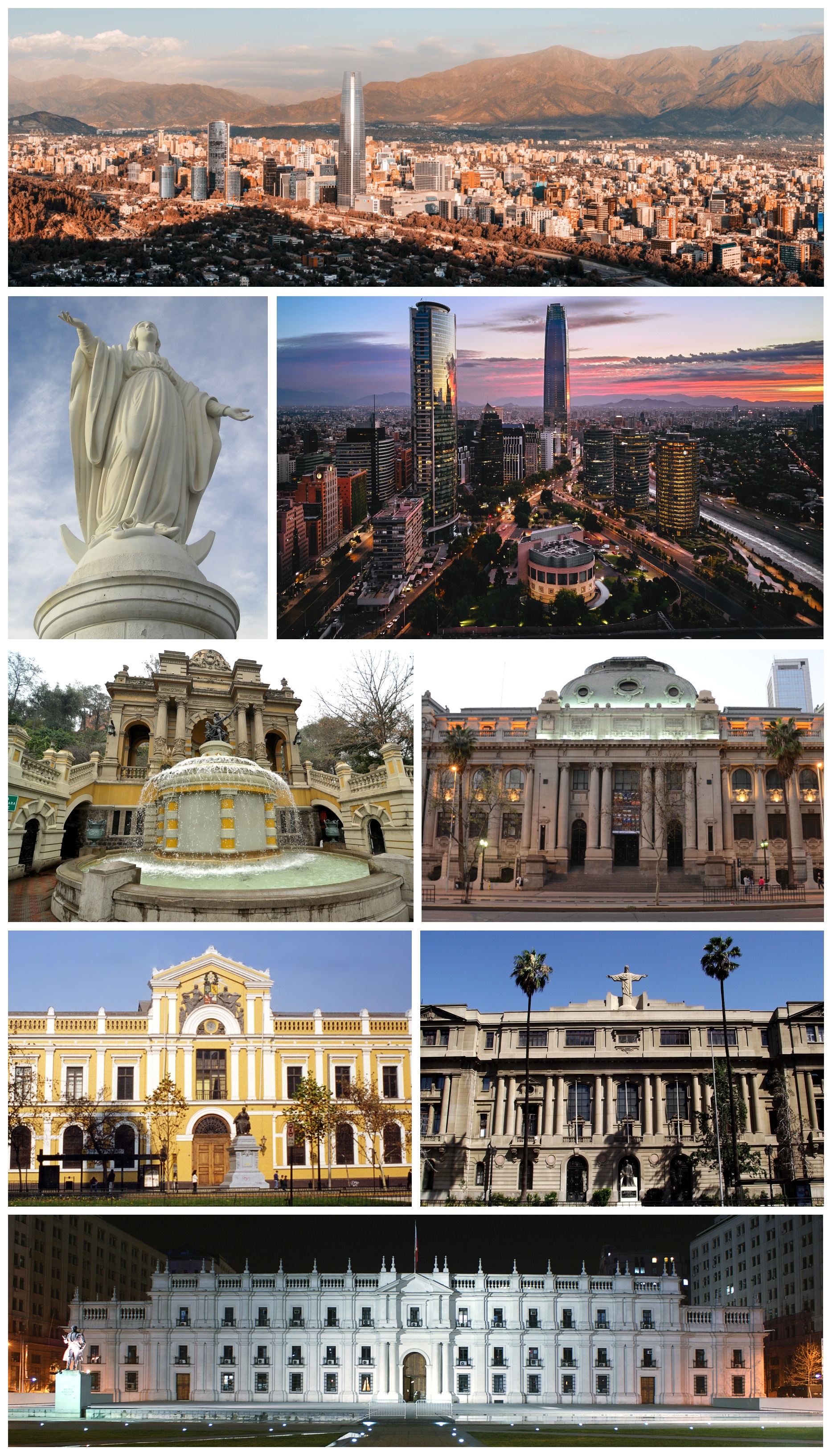
The Gran Torre and 'Sanhattan'
Sources agree that the Gran Torre Santiago, part of the Costanera Center in Providencia, is the tallest skyscraper in South America, at close to 300 meters, and an icon of modern Santiago. The financial sector in the east of the city is popularly known as 'Sanhattan' because of its cluster of towers.
Source: https://es.wikipedia.org/wiki/Gran_Torre_Santiago
The growth of the Santiago Metro
The Santiago Metro, opened in 1975, has expanded steadily to become one of the largest and most modern networks in Latin America, a central factor in the mobility of the contemporary metropolis.
Source: https://es.wikipedia.org/wiki/Metro_de_Santiago

📚 Bibliography

  • Wikipedia (ES) — «Santiago de Chile»: https://es.wikipedia.org/wiki/Santiago_de_Chile
  • Wikipedia (ES) — «Historia de Santiago de Chile»: https://es.wikipedia.org/wiki/Historia_de_Santiago_de_Chile
  • Wikipedia (EN) — «Santiago»: https://en.wikipedia.org/wiki/Santiago
  • Wikipedia (ES) — «Pedro de Valdivia»: https://es.wikipedia.org/wiki/Pedro_de_Valdivia
  • Wikipedia (ES) — «Inés de Suárez»: https://es.wikipedia.org/wiki/In%C3%A9s_de_Su%C3%A1rez
  • Wikipedia (ES) — «Joaquín Toesca»: https://es.wikipedia.org/wiki/Joaqu%C3%ADn_Toesca
  • Wikipedia (ES) — «Benjamín Vicuña Mackenna»: https://es.wikipedia.org/wiki/Benjam%C3%ADn_Vicu%C3%B1a_Mackenna
  • Wikipedia (ES) — «Golpe de Estado en Chile de 1973»: https://es.wikipedia.org/wiki/Golpe_de_Estado_en_Chile_de_1973
  • Wikipedia (ES) — «Gran Torre Santiago»: https://es.wikipedia.org/wiki/Gran_Torre_Santiago
  • Memoria Chilena (Biblioteca Nacional de Chile) — «Fundación de Santiago»: https://www.memoriachilena.gob.cl/602/w3-article-3536.html
  • Museo de la Memoria y los Derechos Humanos (oficial): https://mmdh.cl/

❓ Frequently asked questions

How much does Sky Costanera cost and is it worth it?+
Sky Costanera, the highest viewing deck in South America (floors 61-62 of the Gran Torre), has an official rate of $25,000 CLP for adults during the day and $30,000 CLP for the 'sunset' slot (16:00-18:00), with children aged 5 to 12 at $10,000 CLP and under-4s free (verified July 2026). Advance sales and aggregators often carry lower promotional rates, so it's worth comparing and buying online. It's worth it for the 360° view over the city and the cordillera, but the key is going on a clear day (no smog or cloud) and, if you can, at dusk. Open from 10:00 to 22:00.
How do I get around the city and how much does transport cost?+
The Santiago Metro is the best option: extensive, fast, safe and clean. After the February 2026 increase, a trip costs $735 CLP off-peak, $815 CLP mid-range and $895 CLP at rush hour (7:00-8:59 and 18:00-19:59); Red buses have a flat fare of $795 CLP at any time. Everything is paid with the bip! card (it costs around $1,550 CLP and is rechargeable), which gives you up to two free transfers within 2 hours combining metro and bus. For what the metro doesn't cover and at night, the most comfortable option is a taxi or an app (Uber, Cabify, DiDi).
How much does it cost to get from the airport to downtown?+
There are several options. The cheapest are the Centropuerto and Turbus Aeropuerto buses, which cost approx. $1,800–2,000 CLP per person and reach Terminal Alameda (Universidad de Santiago metro) in about 30-45 minutes. An official taxi or an app to downtown or Providencia costs approx. $18,000–30,000 CLP depending on traffic (15-20 km). Avoid the informal taxis touting for business inside the airport.
Is Santiago safe to travel to?+
Santiago is, on the whole, a comfortable and enjoyable city for tourists, with good services and excellent transport. As in any big city, take basic precautions: watch your phone and belongings in busy areas (downtown, markets, transport at peak hours), don't display valuables, carry little cash and, at night, prefer a taxi or app and well-lit areas. The tourist neighborhoods (Lastarria, Bellavista, Providencia, Las Condes) are calm with a bit of common sense. Stay alert during demonstrations, which occasionally gather downtown.
When is the best time to visit Santiago?+
Spring (September to November) and autumn (March to May) are usually the best seasons, with pleasant temperatures and sunny days. Summer (December to February) is dry and very hot, good for pools and terraces; winter (June to August) is cool and can bring smoggy days in the basin, but it's ski season in the nearby Andes and gives you the snow-covered cordillera as a backdrop. To see the cordillera clearly, pick clear days, which are common after rain or wind.
Which day trips from Santiago are worth doing?+
Santiago is an ideal base for excursions. The most popular: a wine tour of the Maipo Valley wineries (approx. $50,000–90,000 CLP with transport); the Cajón del Maipo with the spectacular Embalse El Yeso (tours from around $41,000 CLP per person); a getaway to Valparaíso and Viña del Mar on the coast ($45,000–75,000 CLP); and, in winter, a ski day at Valle Nevado, Farellones or La Parva. Prices verified July 2026; confirm when booking.
How much do museums cost in Santiago?+
Many of the major museums have free general admission, such as the Museo de la Memoria y los Derechos Humanos, the Museo Histórico Nacional and the Museo Nacional de Bellas Artes. The Museo Chileno de Arte Precolombino charges non-resident foreigners around $7,000 CLP (general) and $2,000 (students), while Chileans and residents pay reduced rates ($1,000 / $500) and the first Sunday of the month is free. Neruda's La Chascona house-museum costs around $7,000–8,000 CLP general. Prices verified July 2026.
Are Cerro San Cristóbal and Sky Costanera both worth doing?+
Yes, both offer spectacular views, but they're different experiences. Cerro San Cristóbal (with its historic funicular from around $3,650 CLP round trip and the Virgin at the summit) is a large natural park, ideal by day and in the open air. Sky Costanera, in the Gran Torre, is the highest viewing deck in South America, perfect at dusk for watching the city light up. In both cases, the key is going on a clear day so the cordillera shows cleanly.
Sources consulted (20)
Still planning?
Explore more destinations in Chile
See all destinations →
Advertisements
Image credits
Photos from Wikimedia Commons, each under its own licence (CC BY, CC BY-SA or public domain). Open each file to see its author and licence.
Montaje de Santiago de Chile (202103220)