Viajá con Gus
Home › Chad › Tibesti Massif
Tibesti Massif
🇹🇩 Chad · The Tibesti

Tibesti Massif

🪪 What do I need to enter Chad?Pick your citizenship and we tell you the visa, the days and the paperwork, with the official source.

By leaving your email and citizenship you agree to receive the documents you asked for and weekly travel news. You can unsubscribe whenever you want. How we handle your data.
Jump to what you need
📌Safety warning — READ FIRST
The Tibesti is one of the most sensitive destinations in Africa. France classifies it as a red zone —travel formally advised against— and places the town of Bardaï in orange, expressly recommending access by air rather than by road because of the risk of mines and the state of the tracks (update of 1 July 2026). Canada advises against all travel to the Tibesti and to anywhere within 30 km of an international border (update of 8 July 2026). The risks are concrete and documented: anti-personnel mines left over from decades of conflict, especially in the border strip with Libya; armed groups moving in from southern Libya; smuggling of weapons, fuel and people; and an artisanal gold economy that has led to armed clashes with dozens and up to a hundred deaths at the Kouri Bougoudi camps and in the Miski area between 2018 and 2022. There is no medical care and no possibility of rapid rescue. This guide informs; it does not recommend the trip.
📌What it is
A volcanic mountain range in the middle of the Sahara, in the far north of Chad —with a smaller portion already in Libyan territory—, covering some 100,000 km². It is the desert's great mountain massif and one of the most remote mountain deserts on the planet: five shield volcanoes, gigantic calderas, lava fields, active fumaroles and hot springs.
📌Peaks and figures
Emi Koussi, at 3,415 metres, is the highest point in Chad and in the whole Sahara. Tarso Toussidé tops out at Pic Toussidé, 3,296 metres. The Trou au Natron crater is about 8 kilometres across and 768 metres deep. Volcanic activity began in the Oligocene and continues today in geothermal form.
📌Active volcanism
The massif is not dead. The Soborom hot springs emerge at between 22 and 88 °C, there are fumaroles at Tarso Voon and Pic Toussidé, and on the southern flank of Emi Koussi the Yi Yerra springs come up at 37 °C. It is the most important geothermal activity in the Sahara.
📅Climate
Less than 20 mm of rain a year, although precipitation increases with altitude. The height produces a surprising anomaly: at the highest elevations it snows roughly once every seven years. Nights in the massif are very cold even in the depths of the Saharan winter, and daily temperature swings are huge.
📌Population
This is the land of the Toubou people, above all the Teda group. Bardaï, the regional capital, sits at 1,020 metres, and Zouar lies to the southwest. Official figures went from about 21,000 inhabitants in 2009 to about 54,000 in 2017, but the number of permanent residents may be around 10,000-15,000 given the semi-nomadic nature of the population.
📌How to visit
Only on an expedition organised by a specialist operator, with Toubou guides, a vehicle convoy, permits from the Ministry of the Interior and authorisations for the north. The existing commercial programmes are long treks, with an ascent of Emi Koussi and a combination with the Ounianga lakes. The operating season runs from November to March.
📌Permits
Visa (e-visa since December 2024), yellow fever certificate, autorisation de circuler from the Ministry of the Interior, official photography permit and specific authorisations for the north. Foreign ministries also warn that overland travel requires prior coordination, a security-forces escort depending on the area, a convoy of at least two vehicles, daytime driving only and advance notice to the authorities.
💱 XAF exchange rate
Loading rate…
🌤️ Weather in Tibesti Massif
Loading weather…

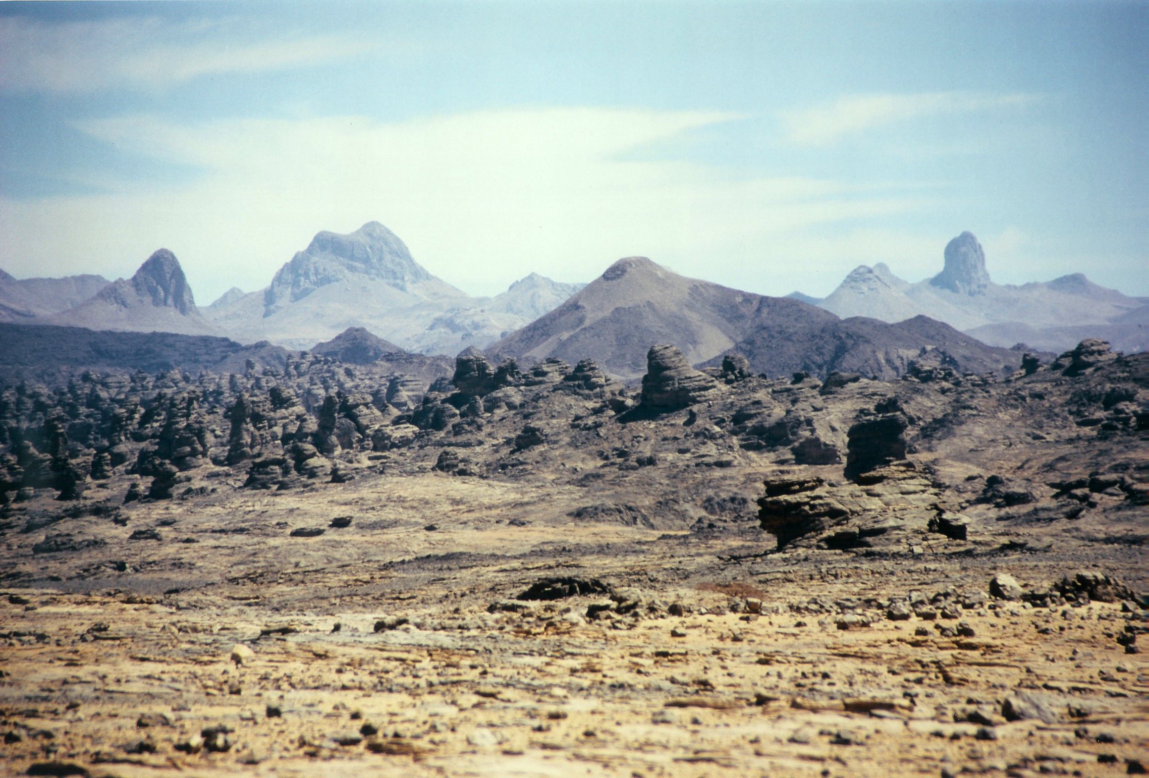
The Tibesti is the mountain of the Sahara. A hundred thousand square kilometres of shield volcanoes, calderas eight kilometres across, black lava fields, basalt spires and fumaroles smoking in the middle of the desert, crowned by Emi Koussi, which at 3,415 metres is the roof of Chad and of the whole Sahara. In a desert the imagination associates with flatness, the Tibesti is vertical, dark and volcanic.

It is also, in all likelihood, the least visited mountain massif of its kind in the world. It lies in the corner where Chad meets Libya and Niger, more than a thousand kilometres from the capital, with no paved roads, no phone coverage, no hospitals, no reliable fuel and a history of conflict running through the whole of the 20th century and much of the 21st: civil wars, Libyan occupation, the Toyota War, anti-personnel mines laid along the border strip and, for a little over a decade, a gold rush that has brought thousands of artisanal miners, tensions with Toubou communities and armed clashes with dozens of deaths.

This page explains what the Tibesti is —spectacular geology, rock art, Teda culture, one of the great goals of Saharan exploration— and also, without embellishment, what going there involves: an area formally advised against by France and Canada, a three-week expedition with Toubou guides, and the certainty that in the event of an accident there is no rescue possible within a reasonable time.

📖 History of Tibesti Massif

The Tibesti began to form in the Oligocene, when intraplate volcanism raised over the Saharan shield a range of shield volcanoes that culminates in Emi Koussi (3,415 m), the highest point in the Sahara, and includes calderas such as the Trou au Natron, 8 km across and 768 m deep. Its rock and cave art records a past biodiversity very different from today's, a legacy of the green Sahara. For centuries it was the autonomous territory of the Toubou people, and in particular the Teda, who controlled the caravan routes between the Libyan Fezzan and the Sahel. French forces entered in 1914 and did not consolidate control until the late 1920s, incorporating the massif into the military administrative unit of Borkou-Ennedi-Tibesti. After independence in 1960, the region was one of the hotspots of the Chadian civil war of 1965-1979 and became caught up in the dispute with Libya over the Aouzou Strip, which culminated in the Toyota War of 1987 and the 1994 International Court of Justice ruling in Chad's favour. Since the early 2010s, the discovery of gold at Kouri Bougoudi and in the Miski area has sparked a mining rush that has led to recurring armed clashes; the anti-personnel mines laid during the wars remain an active danger.

Read the full history ↓

🏛️ Tibesti Massif is in the Tibesti

Volcanoes over three thousand metres high in the heart of the Sahara, land of the Teda and scene of wars, landmines and gold rushes. The roof of the desert, and its most difficult corner.

Read the history of The Tibesti →

🗺️ What to see

1
The roof of the Sahara: 3,415 metres of colossal shield volcano, with nested calderas, lava fields and secondary cones. Its ascent is the classic goal of trekking expeditions to the Tibesti, technically manageable but logistically extreme. It has its own entry in this guide.
2
Trou au Natron (Doon Orei)
The massif's most striking image: a caldera about 8 kilometres across and 768 metres deep, its floor covered with a white crust of sodium carbonate —natron— that contrasts sharply with the black basalt walls and with the volcanic cones rising inside the crater itself. It is one of the most spectacular volcanic landscapes in the world.
3
Pic Toussidé and Tarso Toussidé
Pic Toussidé, at 3,296 metres, is the massif's second giant and one of its centres of active geothermal activity, with steaming fumaroles. The Tarso Toussidé complex, with its relatively recent lava flows, is the youngest volcanic area of the Tibesti.
4
Soborom hot springs
An active geothermal field with springs whose waters emerge at between 22 and 88 °C, sulphur deposits, coloured muds and a smell of sulphide. The Toubou traditionally use it for therapeutic purposes. It is the most tangible proof that the Tibesti is still alive beneath the surface.
5
Tarso Voon fumaroles
Another of the massif's active geothermal centres, with vents of steam and gas inside the caldera. Together with Soborom and Pic Toussidé, they make up the most important geothermal system in the whole Sahara.
6
Yi Yerra springs
On the southern flank of Emi Koussi, hot springs that emerge at about 37 °C. They are a regular stop on trekking itineraries that circle or climb the volcano, and a vital water point in an area that has no other.
7
Bardaï
The capital of the Tibesti, at 1,020 metres, in a wadi wedged between rock walls. It is the administrative, commercial and logistical centre of the massif and the place where checkpoints are cleared and guides are hired. France classifies it as orange —travel advised against unless essential— and recommends arriving by plane.
8
Zouar
The massif's other reference town, to the southwest, on the approach from the south. It serves as a transit and resupply point on itineraries that enter the Tibesti without going through Bardaï.
9
The massif's rock art
The walls and rock shelters of the Tibesti hold rock and cave art that records a past biodiversity radically different from today's: savannah wildlife, cattle, hunting scenes. It is the same story of the green Sahara told by the Ennedi and Algeria's Tassili, and one of the cultural reasons for scientific interest in the massif.
10
Lava fields and volcanic spires
Black lava flows, slag fields, domes and volcanic plugs rising out of sandy plains. The combination of dark basalt, golden sand and clear sky creates a colour contrast found in no other Saharan massif.
11
Teda culture
The Tibesti is Toubou land, and in particular Teda: a society of herders and caravaneers famed for their extreme toughness, adapted to one of the most hostile environments on the planet, who for centuries controlled the routes between the Libyan Fezzan and the Sahel. Expedition guides are French-speaking Toubou, and their knowledge of the terrain is what makes the trip possible.
12
Snow in the Sahara
A genuine curiosity: at the massif's highest elevations it snows roughly once every seven years. It is one of the few places in the Sahara where snow is not an isolated climatic oddity but a recurring phenomenon, a result of altitudes of over 3,000 metres.
📶I have never landed without internet. I arrive and my phone connects to the strongest network in the country I am visiting: I can say I landed, sort out transport, book tours and keep posting, at a seriously good price. I always use the Maya eSIM — check their plans by clicking the banner.See plans →Maya Mobile eSIM — turn travel mode on
What nobody tells you

💵 Prices

Tickets

TypePrice
Acceso al macizoThere is no ticketing system: the Tibesti is not a park with a gate. What you need are the official permits and, depending on the area and the moment, an escort and military authorisation (2026)
Autorisation de circuler y permiso de fotografíaRequired to leave N'Djamena and to take photographs in the country; operators handle them. They are issued by Chad's Ministry of the Interior and Public Security. No Chadian body publishes the fee: the 2026 General Tax Code (452 pages, Directorate General of Taxes, 08/04/2026) sets no rate for the autorisation de circuler, and the websites of the Ministry of the Interior, the Journal Officiel and the Ministry of Security do not resolve or are down (verified 10/08/2026). Reference, not current (2026)
Autorizaciones específicas para el norteCommercial programmes include admission and permits in the price, with no public breakdown. Foreign ministries also warn of escort requirements, a minimum convoy of two vehicles and advance notice to the authorities. Reference, not current (2026)
Guías toubou localesIncluded in expedition programmes, which work with French-speaking Toubou guides. No public daily rate. Reference, not current (2026)
🔄 updated monthlyOfficial / reference values · double-check when buying

Activities and tours

Tibesti trek with ascent of Emi Koussi (3,415 m) and the Ounianga lakes
Duration21 days
OperatorTamera and Saharan trekking operators
Price
From EUR 5.395 per person in a group of 4 to 7 participants, and EUR 7.300 for a private version based on 2 people, on Tamera's 21-day programme. Includes international flights, transfers, accommodation, meals, guide, equipment and admission; run with French-speaking Toubou guides and with a spare day built in in case of mechanical setbacks (published operator rate, 2026)
Ascent and exploration of the Trou au Natron
Duration1 to 2 days
OperatorExpedition operator
Price
Included in programmes that reach the northern sector of the massif; not sold separately (2026)
Visit to the Soborom hot springs
PriceIncluded in itineraries that pass through the sector (2026)
DurationHalf a day
OperatorExpedition operator and Toubou guides
Bivouac and stargazing in the massif
DurationEvery night of the programme
OperatorExpedition operator
Price
Included: there is no accommodation and you always sleep in a bivouac (2026)
Tour of the Borkou tassilis and rock art
Duration1 to 3 days
OperatorExpedition operator
Price
Included in long programmes combining Tibesti, Borkou and Ounianga (2026)
🔄 updated monthlyOfficial / reference values · double-check when buying

🚌 How to get there and distances

Getting around

4x4 convoy
PricePart of the expedition programme (2026)
DurationDays
Notes
Foreign ministries warn that overland travel in the north requires prior coordination, a convoy of at least two vehicles, daytime driving only and notice to the authorities; depending on the area, a security-forces escort
On foot (trekking)
Included in trekking programmes
DurationSeveral hours a day
Notes
The Tibesti's commercial programmes are treks and require good physical fitness and regular exercise. The terrain is volcanic, abrasive and has no trails
Camels and local logistical support
Part of the programme (2026)
DurationDays
Notes
Treks use camel or vehicle support depending on the stage. The guides are Toubou and have the final say on the itinerary and on safety
Plane to Bardaï
DurationA few hours versus several days on tracks
Price
Subject to availability; there is no regular commercial service (2026)
Notes
This is the access France expressly recommends over the road, because of the risk of mines and the poor state of the tracks
🔄 updated monthlyOfficial / reference values · double-check when buying

How to get there

RouteAirlines / operatorsAvg. priceDuration
N'Djamena → Tibesti by trackExpedition convoyPart of the programme (2026)Several days of open desert; the massif is more than a thousand kilometres from the capital
N'Djamena → Faya-LargeauExpedition 4x4 or flight to the local airfieldPart of the programme or subject to flight availability (2026)About 790 km northeast of the capital; it is the main logistics hub of the north
Faya-Largeau → Tibesti (Zouar or Bardaï)Expedition convoyPart of the programme (2026)Several days on tracks
N'Djamena → Bardaï by planeNo regular commercial service; flights subject to availabilitySubject to availability (2026)A few hours; it is the route France recommends over the road
Tibesti → Ounianga LakesExpedition convoyPart of the long programmes, from EUR 5.395 per person for 21 days (2026)Several days of open desert
🔄 updated monthlyOfficial / reference values · double-check when buying

🏨 Where to stay

No exact prices: a scale from $ (budget) to $$$$$ (luxury), with 2-3 options per category.

Bivouac (the only option)
Price$$$$$
Recommended options
There are no hotels or tourist camps in the Tibesti. You sleep in a bivouac, in basic conditions, with equipment provided by the expedition. Nights at altitude are very cold: you need a winter sleeping bag
Bardaï and Zouar
Price$$$$$
Recommended options
The two reference towns have very basic accommodation aimed at officials, traders and miners, with no tourist infrastructure at all. Bardaï is at 1,020 metres
Faya-Largeau
Price$$$$$
Recommended options
The main urban centre of Borkou, with an airfield and basic accommodation. It is the only town in the north that Canada exempts from its advice to avoid all travel to the region
N'Djamena, before and after
Price$$$$$
Recommended options
Radisson Blu N'Djamena between USD 126 and USD 333 a night according to aggregators, with an average paid of around USD 186; Ledger Plaza around USD 257 (July 2026)

🍴 Where to eat

Cocina de expedición
Price$$$$$
Options / signature dish
Everything is cooked at camp during the three weeks of the programme: pasta, rice, stews, pulses, hardy vegetables, dried fruit and bread baked at the bivouac. Water and food logistics for the Tibesti are the heaviest part of the trip
Té toubou
Price$$$$$
Options / signature dish
Very sweet green tea served in several rounds, the basic social ritual of northern Chad. With the Teda guides it is drunk several times a day
Bardaï y Zouar
Price$$$$$
Options / signature dish
Very simple eateries serving rice, pasta, grilled meat, dates and tea, in the massif's two reference towns
Yamena, antes y después
Price$$$$$
Options / signature dish
Lebanese, French and international restaurants in the capital, and the classic grilled Chari capitaine

📖 History of Tibesti Massif

Origins, formation and what the sources say.

Fire beneath the Sahara: how the Tibesti was formed

The Tibesti is a geological anomaly in the heart of the Saharan shield. Almost the whole desert is a platform of ancient rock covered in sand and flat-lying sandstone. Here, though, the ground split open and poured out lava for tens of millions of years. The result is a volcanic range of some 100,000 km², mostly in northern Chad, with a smaller part across the border in Libya.

The activity began in the Oligocene and built five large shield volcanoes, the gently sloping giants with enormous bases that runny lava produces. The largest is Emi Koussi. At 3,415 metres it is the highest point in Chad and in the whole Sahara: a colossal volcano with nested calderas, secondary cones and lava fields. Tarso Toussidé, topped by the 3,296-metre Pic Toussidé, is the youngest volcanic sector of the massif.

The most spectacular feature isn't a summit but a hole. The Trou au Natron is a caldera about 8 kilometres across and 768 metres deep. Its floor is covered in a white crust of sodium carbonate, called natron, which stands out sharply against the black basalt walls and the volcanic cones rising inside the crater itself. It is one of the most striking geological sights on the planet, and one of the least seen.

The massif isn't extinct. The Soborom hot springs come out at between 22 and 88 °C, with sulphur deposits and coloured mud. There are active fumaroles on Tarso Voon and Pic Toussidé, and on the southern flank of Emi Koussi the Yi Yerra springs flow at 37 °C. It is the most important geothermal system in the Sahara.

The altitude also creates a remarkable climate anomaly. The massif gets less than 20 mm of rain a year, but rainfall increases with height, and on the highest ground it snows roughly once every seven years.

en.wikipedia.org · Tibesti Mountainsen.wikipedia.org · Trou au Natron

The Teda: a thousand years of self-rule in the desert

The Tibesti is Toubou land, and in particular the land of the Teda group. They are one of the societies best adapted to extreme living conditions anywhere on the planet: camel and goat herders, date growers in the wadis, caravan traders and warriors. Their reputation for toughness runs through every historical account of the region.

Their location made them players in long-distance trade for centuries. The Tibesti sits right between the Libyan Fezzan and the Sahel, on the routes that linked the Mediterranean with Lake Chad. Salt, natron, dates, copper, cloth, weapons and slaves all passed through, and whoever controlled the massif's wells and passes controlled the traffic.

The Teda never built a centralised state. They organised themselves into clans with rights over wells, palm groves and pastures, under a traditional authority, the derde, who acted more as an arbiter than a ruler. That decentralised structure, together with the brutal terrain, made the Tibesti practically impossible to conquer.

The rock art and wall paintings scattered across the massif show wildlife very different from today's: savannah animals and cattle, evidence of the Green Sahara and of a time when these mountains had running water and grasslands. The Ennedi and Algeria's Tassili tell the same story, painted on the walls of a desert that wasn't a desert back then.

Today the Tibesti's population varies a lot depending on the source. Official figures give about 21,000 inhabitants in 2009 and about 54,000 in 2017, while estimates of permanent residents are much lower, around 10,000-15,000, because many families are semi-nomadic. Bardaï, at 1,020 metres, is the regional capital, and Zouar, to the south-west, is the other main town.

en.wikipedia.org · Tibesti Mountainsen.wikipedia.org · Toubou people

France, independence and the first civil war

The colonial conquest of the Tibesti came late and was hard going. French forces entered the massif in 1914 but didn't secure control until the late 1920s, almost thirty years after they had settled in the Chari basin. The massif became part of the military region of Borkou-Ennedi-Tibesti, the BET, which was run separately from the south and had very little state presence.

Independence on 11 August 1960 didn't end this neglect. Quite the opposite. The new Chadian state was dominated by elites from the Christian and animist south, and in the Muslim, herding north their administration felt like a second colonisation, this time by fellow citizens. Abuses by officials sent to the BET come up again and again as a trigger in every account of the conflict.

The rebellion broke out in 1965. In 1966 FROLINAT, the National Liberation Front of Chad, was founded and found an ideal refuge in the Tibesti: a massif the size of a European country, with no roads, wells known only to locals and a direct border with Libya. The Tibesti was one of the most persistent hotspots of the 1965-1979 Chadian civil war, with repeated French military interventions and a civilian population caught in the middle.

That period left two very physical legacies. One is a deep-rooted distrust between Teda communities and the central state, which comes back with every later crisis. The other is the minefields laid over decades, which still kill and maim people in the massif and especially along the border strip with Libya.

en.wikipedia.org · Tibesti Mountainsbritannica.com · Chad

Libya, the Aouzou Strip and the Toyota War

In 1973 Libya occupied the Aouzou Strip, a band about a hundred kilometres wide in the far north of Chad that includes part of the Tibesti. It claimed rights based on a Franco-Italian agreement that was never ratified. The occupation lasted two decades and turned the massif into a front line.

During the 1980s, Tripoli backed Chadian factions, sent armoured units into the desert and set up bases in the north. Chad hit back in 1987 with the campaign the press called the “Toyota War”: columns of light pickups armed with machine guns and MILAN anti-tank missiles that tore apart conventional armoured formations. The decisive moment was the Battle of Fada, in the Ennedi, on 2 January 1987. Libya and the CDR lost 784 men, against 18 Chadians, and 92 tanks were destroyed. That same year, Chadian forces took back positions in the north and even attacked Libyan bases across the border.

The dispute was finally settled in court. On 3 February 1994 the International Court of Justice ruled in Chad's favour on the Aouzou Strip, and Libya completed its withdrawal that same year. It was one of the few cases where an international court actually ended an African territorial conflict.

But peace didn't come to the Tibesti. As a corridor between southern Libya and the Sahel, it stayed a transit zone for weapons, fuel, migrants and armed groups. In April 2021, the column from FACT (Front for Change and Concord in Chad) that caused the death of President Idriss Déby entered the country from southern Libya, through exactly this side of the desert.

en.wikipedia.org · Toyota Waren.wikipedia.org · Battle of Fada

Gold fever: Kouri Bougoudi, Miski and today's violence

In the early 2010s, the discovery of alluvial gold in northern Chad set off a gold rush that completely changed the Tibesti's economy. Thousands of prospectors came from Chad, Libya, Niger and Sudan to the Kouri Bougoudi fields, the country's largest deposit, and to the Miski area. They brought diggers, metal detectors, weapons and smuggled fuel.

A clash with the state was bound to happen, and suspicion ran both ways. The authorities assumed the miners were working with Chadian rebels based in southern Libya. The local Tebu communities suspected the government wanted to take over gold they saw as their own.

In August 2018, the CCMSR, a Libya-based rebel group, attacked a Chadian army unit near Kouri Bougoudi. This set off a major campaign of reprisals against the Tibesti's goldfields. Late that year the army attacked Miski with air strikes, a ground offensive and a strict blockade, even though there were no rebels in Miski and the local Tebu community had no links to the CCMSR. The troops then pulled back about a hundred kilometres but kept access closed. In January 2019, several dozen people died in Kouri in fighting between Libyan Arabs and people from Chad's eastern Ouaddaï region. And in May 2022, clashes between groups of miners in the north left around a hundred dead.

On top of all this there's the inherited problem: the anti-personnel mines laid during the wars are still an active danger, especially along the Libyan border. It's one of the reasons France explicitly gives for recommending that travellers reach Bardaï by plane rather than by road.

The result is a massif of extraordinary geological and cultural value that France classifies as a red zone and Canada lists as “avoid all travel” in their July 2026 updates. There are commercial trekking programmes that operate with French-speaking Toubou guides, who have full authority over the route and over security. The main one lasts 21 days, includes climbing Emi Koussi and the Ounianga lakes, and starts at 5,395 euros per person in a group of 4 to 7. Still, the Tibesti remains by far Chad's most demanding and sensitive destination, and probably one of the hardest in Africa.

crisisgroup.org · 274 tchad sortir de la confrontation miskifrance24.com · 20220530 around 100 dead in clashes between…

📚 Bibliography

  • Wikipedia (EN) — «Tibesti Mountains»: https://en.wikipedia.org/wiki/Tibesti_Mountains
  • Wikipedia (EN) — «Trou au Natron»: https://en.wikipedia.org/wiki/Trou_au_Natron
  • Wikipedia (EN) — «Emi Koussi»: https://en.wikipedia.org/wiki/Emi_Koussi
  • Wikipedia (EN) — «Toubou people»: https://en.wikipedia.org/wiki/Toubou_people
  • Wikipedia (EN) — «Toyota War»: https://en.wikipedia.org/wiki/Toyota_War
  • Wikipedia (EN) — «Battle of Fada» (2 January 1987): https://en.wikipedia.org/wiki/Battle_of_Fada
  • Wikipedia (EN) — «Battle of Kouri Bougoudi (2018)»: https://en.wikipedia.org/wiki/Battle_of_Kouri_Bougoudi_(2018)
  • International Crisis Group — «Chad: Avoiding Confrontation in Miski»: https://www.crisisgroup.org/africa/central-africa/chad/274-tchad-sortir-de-la-confrontation-miski
  • Global Initiative Against Transnational Organized Crime — «Chad's largest goldfield, Kouri Bougoudi, is central to regional stabilization efforts»: https://riskbulletins.globalinitiative.net/wea-obs-002/01-chads-largest-goldfield-central-to-stabilization-efforts.html
  • France 24 — «Around 100 dead in clashes between Chad gold miners» (May 2022): https://www.france24.com/en/live-news/20220530-around-100-dead-in-clashes-between-chad-gold-miners
  • France Diplomatie — Conseils aux voyageurs, Tchad, Sécurité (updated 1 July 2026): https://www.diplomatie.gouv.fr/fr/information-par-pays/tchad/conseils-aux-voyageurs-securite
  • Britannica — «Chad» and «Tibesti Mountains»: https://www.britannica.com/place/Tibesti-Mountains

❓ Frequently asked questions

Can you travel to the Tibesti?+
There are commercial trekking programmes that do it, but you need to understand the context. France classifies the massif as a red zone —travel formally advised against— and places Bardaï in orange, recommending access by air (update of 1 July 2026); Canada advises against all travel to the Tibesti (8 July 2026). Foreign ministries also warn of requirements for prior coordination, an escort depending on the area, a minimum convoy of two vehicles, daytime driving only and notice to the authorities. Anyone who travels should assume their insurance will probably not cover them and that no rescue is possible within a reasonable time.
What is the risk from landmines?+
Real and documented. Anti-personnel mines laid during the decades of conflict —the Chadian civil war, the Libyan occupation of the Aouzou Strip, the Toyota War— are still there, especially along the Libyan border and in border areas generally. It is one of the reasons France explicitly gives for recommending that travellers reach Bardaï by plane rather than by road. The absolute rule in the massif is never to leave the marked tracks and always to follow the local guide.
What does gold have to do with insecurity?+
A great deal. From the early 2010s, the discovery of gold at Kouri Bougoudi and in the Miski area drew thousands of artisanal miners from Chad, Libya, Niger and Sudan. Tension between the State, which suspected collusion with Chadian rebels based in southern Libya, and the Tebu communities, who saw the gold as their own, turned into open clashes: a military offensive on Miski with air strikes and a blockade in late 2018, fighting at Kouri Bougoudi in 2018 and 2019 with dozens killed, and later violence between groups of miners that left around a hundred dead in 2022.
How long does an expedition last and how much does it cost?+
Commercial programmes are long out of logistical necessity. The benchmark trek lasts 21 days and covers the ascent of Emi Koussi (3.415 m), the calderas of the massif, the Borkou tassilis with their rock art and the lakes of Ounianga. It starts at 5.395 euros per person in a group of 4 to 7 participants, or 7.300 euros as a private trip based on two people. It includes international flights, transfers, accommodation, meals, guide, equipment and admission fees, and is run with French-speaking Toubou guides.
What level of fitness do you need?+
The benchmark programme is rated as sporty and requires regular weekly physical activity. It means three weeks of bivouac, with days of walking over abrasive volcanic terrain with no trails, altitudes of up to 3.415 metres, huge temperature swings and very cold nights. This is not a contemplative trip: it is a mountain expedition in a desert with no rescue infrastructure.
Is it true that it snows in the Tibesti?+
Yes, and it is not a legend. On the highest parts of the massif it snows roughly once every seven years, a direct result of altitudes of more than 3.000 metres in the heart of the Sahara. The massif as a whole gets less than 20 mm of rain a year, but precipitation increases with height, and that combination of altitude and night-time cold produces one of the desert's most counter-intuitive phenomena.

More places in Chad

MoundouParque Nacional de MandaParque Nacional de ZakoumaSarhYamena (N'Djamena)Abéché
See every place in Chad →The history of Chad →
Sources consulted (13)
Still planning?
Explore more destinations in Chad
See all destinations →
Image credits
Photos from Wikimedia Commons, each under its own licence (CC BY, CC BY-SA or public domain). Open each file to see its author and licence.
Tibesti east of bardai