Viajá con Gus
Home › Chad › Ennedi Massif
Ennedi Massif
🇹🇩 Chad · The Ennedi and the northern desert

Ennedi Massif

🪪 What do I need to enter Chad?Pick your citizenship and we tell you the visa, the days and the paperwork, with the official source.

By leaving your email and citizenship you agree to receive the documents you asked for and weekly travel news. You can unsubscribe whenever you want. How we handle your data.
Jump to what you need
📌What it is
A sandstone massif in the heart of the Sahara, in north-eastern Chad, carved by water and wind over millions of years into a maze of canyons, towers, natural arches, rock mushrooms and rocky citadels. It has been a UNESCO World Heritage Site since 2016 as a mixed site —cultural criterion (iii) and natural criteria (vii) and (ix)—, with an inscribed area of 2.441.200 hectares and a buffer zone of a further 777.800.
📌Geology and dimensions
The plateau is made up of sandstones ranging from the Cambrian-Ordovician to the Carboniferous, resting on a granite basement. It covers roughly 60.000 km² —an area comparable to Switzerland— and its highest point is around 1.450 metres. It gets between 50 and 150 mm of rain a year, enough to feed at least twenty or so permanent or semi-permanent springs, gueltas and pools hidden in the canyons.
📌Rock art
One of the largest bodies of rock art in the Sahara: thousands of paintings and engravings in caves, rock shelters and canyon walls, with dates going back some 8.000 years. More than 86 % are paintings and about 14 % engravings. Domestic animals make up nearly 69 % of the figures, with cattle as the undisputed stars: the visual record of a green Sahara full of herders.
📌Management and protection
The massif is part of the Ennedi Natural and Cultural Reserve, covering more than 50.000 km², one of the largest protected areas in Africa. In 2017 the Chadian government signed a fifteen-year agreement with the NGO African Parks, which took over management in February 2018. The relationship went through a crisis in October 2025 —on 6 October the government announced it was terminating the mandates and on the 17th it reversed the decision— and culminated on 2 July 2026 with the signing of new co-management agreements covering the Ennedi, Zakouma, Siniaka-Minia and the Aouk-Keïta landscape.
📌Best time to go
From October to May, and especially from November to March. In those months daytime temperatures are manageable and the nights are genuinely cold: in the high desert you need a winter sleeping bag. From June to September the monsoon rains arrive —scarce, but enough to flood the wadis— and temperatures become unbearable.
📌Getting there
There's no easy way in. Overland, from N'Djamena to Fada —the regional capital and base for the massif— it's about 874 km of track and three or four days of driving via Mao and Kalaït; from Fada, the Guelta d'Archei is another 4x4 stretch away. By air, Fada has an airstrip with a single runway about 10 km from town, and some operators charter flights to save the days on the road. Everything is done in a convoy of Land Cruisers with a cook, a mechanic and a guide.
📌Permits
On top of the visa (e-visa since December 2024) and the yellow fever certificate, you need the autorisation de circuler from the Ministry of the Interior to travel outside N'Djamena, an official photography permit and specific authorisations for the north of the country. Registered operators handle them and include them in the package: travelling independently to the Ennedi is not a realistic option.
📌Safety warning
France classifies the Ennedi as a red zone —travel formally advised against— and leaves the town of Fada in orange, recommending access by air rather than by road because of the risk of mines and the state of the tracks (update of 1 July 2026). Canada advises against all travel to the north of the country, including the Ennedi provinces, and to anywhere within 30 km of a border (update of 8 July 2026). The specific risks: kidnapping of Westerners, armed groups moving in from Libya and Sudan, anti-personnel mines in border areas and total medical isolation. In practice, whatever tourism exists is done with specialist operators, government permits and convoys; anyone who goes should assume their travel insurance probably won't cover them in a zone that is formally advised against.
💱 XAF exchange rate
Loading rate…
🌤️ Weather in Ennedi Massif
Loading weather…

The Ennedi is the closest thing in Africa to a different planet. Picture the Sahara and then cross out the image of endless dunes: here the desert is red rock, and that rock is carved into sheer-walled canyons, hundred-metre spires, arches spanning the sky, rock mushrooms in impossible balance and mazes of towers where it's easy to get lost for days. UNESCO declared it a World Heritage Site in 2016 as a mixed natural and cultural site, and nobody is exaggerating when they call it Chad's great wonder.

The astonishing part is that it also has water. Between 50 and 150 millimetres of rain a year, trapped in the porous rock, feed at least twenty or so springs and gueltas hidden at the bottom of the canyons, where desert crocodiles, European migratory birds and whole palm groves survive a thousand kilometres from any river. On the walls of those same canyons there are thousands of paintings and engravings up to 8.000 years old, dominated by herds of cattle: the visual archive of the green Sahara, drawn by the people who saw it.

The other side needs saying too. The Ennedi is in a zone formally advised against by Western foreign ministries, three or four days by track from the capital, with no medical infrastructure or phone coverage, and with real risks of kidnapping and of armed groups moving between Libya, Sudan and Chad. The tourists who do come —a few hundred people a year— travel in 4x4 convoys organised by specialist operators who handle the government permits. This page covers the heritage in the detail it deserves, and also what you need to know before deciding.

📖 History of Ennedi Massif

The Ennedi is a fragment of an ancient seabed: sandstones laid down between the Cambrian-Ordovician and the Carboniferous on a granite base, uplifted and then sculpted over tens of millions of years by water and wind into today's maze of canyons, arches and towers. Its human history is written on its walls: some 8.000 years ago, during the African Humid Period, this was a savannah landscape with lakes, rivers and herds, and its inhabitants left one of the largest bodies of rock art in the Sahara, with more than 86 % paintings and 69 % of figures showing domestic animals, above all cattle. When the Sahara dried out —between 7.500 and 5.000 years ago— life retreated to the few permanent water sources, and some of its inhabitants stayed: the crocodiles of the Guelta d'Archei are literally survivors of that world. Since then the massif has been the territory of Toubou and Zaghawa nomadic herders. UNESCO inscribed it as a World Heritage Site in 2016, and in 2017-2018 the Chadian government handed its management to African Parks, within a natural and cultural reserve of more than 50.000 km².

Read the full history ↓

🏛️ Ennedi Massif is in Ennedi and the northern desert

A 60.000 km² sandstone massif full of arches, towers and canyons, with paintings 7.000 years old, crocodiles that outlived the green Sahara and eighteen lakes that shouldn't exist.

Read the history of Ennedi and the northern desert →

🗺️ What to see

1
Guelta d'Archei
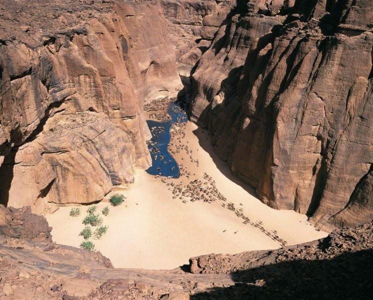
The most famous site in the massif and one of the iconic images of the Sahara: a narrow black-walled gorge where water stays all year round, hundreds of camels come down to drink every afternoon and a tiny relict population of West African crocodiles (Crocodylus suchus) survives. You get there after several days by 4x4 from N'Djamena, and the last stretch is on foot through the canyon.
2
Aloba Arch
One of the tallest natural arches in the world: about 120 metres high with a span of about 77 metres, making it the eighth-longest known natural span on the planet and the largest outside China and Utah. It's tucked away in the eastern sector of the massif, and seeing it up close means a walk along the wadi; the scale only sinks in when you put someone underneath it in the photo.
3
Djoulia Arch
Another of the Ennedi's great arches, easier to reach than Aloba and much photographed at sunrise and sunset, when the sandstone shifts from orange to deep red. The massif has dozens of catalogued arches and probably many more uncatalogued: an estimated 75 % of the Ennedi has yet to be explored in detail.
4
Niola Doa
The most unusual rock art site in the massif: a group of engravings of almost life-size, richly decorated female figures, about 7.000 years old. Its name is usually translated as «the place of the girls». It's unlike anything else in the Sahara and lies in a remote corner of the massif, which makes it an expedition within the expedition.
5
Terkei
A rocky outcrop with open, interconnected caves whose name translates as «the white pools». It holds one of the finest groups of paintings in the Ennedi: a true «army» of riders, plus giraffes, goats, camels and a huge cow painted on the ceiling of one of the caves.
6
Manda Guéli
In the Archei area, one of the best-preserved caves in the massif, famous for its paintings of men riding camels, with their African saddles, swords, ornaments and hairstyles perfectly recognisable. It records the most recent phase of the rock art, when the camel had already replaced the cattle of the green Sahara.
7
The labyrinths and stone forests
Whole sectors of the massif where differential erosion has left forests of spires, towers and balanced sandstone mushrooms, threaded by sandy corridors. You explore them by 4x4 and on foot, and this is where you camp: sleeping in a red-rock amphitheatre under a sky with no light pollution is, for many people, the moment of the trip.
8
The gueltas of the massif
Besides Archei, the Ennedi has at least twenty or so permanent or semi-permanent springs, gueltas and pools hidden in the canyons, each with its own microcosm of vegetation, birds and nomadic livestock. They are the points around which human and animal life in the massif is organised, and they explain why there is herding in the middle of the Sahara.
9
Saharan wildlife
The Ennedi is a biological refuge: dwarfed West African crocodiles in the canyon pools, ostriches —25 individuals counted in 2022—, aoudad or Barbary sheep on the rock faces, gazelles and at least 199 catalogued species of migratory birds, many of them European birds that stop over here. It's one of the reasons for UNESCO's natural criterion (ix).
10
Fada, the oasis town
The capital of Ennedi-Ouest province and the logistics base for the massif: about 23.800 inhabitants according to the 2005 census, an airstrip 10 km away, palm groves and the last proper resupply point before heading into the rock. Every itinerary passes through here.
11
Expedition camps
There are no hotels in the Ennedi: you sleep in a tent or under the stars, in camps the operators set up in rock amphitheatres and in the shelter of the canyons. Some itineraries use fixed seasonal bases, such as Camp Derde, from which they fan out for several days to the rock art sites and the gueltas.
12
FICSA, the International Festival of Saharan Cultures
The Chadian state relaunched the north-east's Saharan festival in February 2026: the sixth edition was held from 7 to 13 February 2026 in Amdjarass, under the patronage of President Mahamat Idriss Déby, with camel and horse races, intangible heritage workshops, crafts, music and debates on sustainable tourism. It's the most visible attempt to revive cultural tourism in the Ennedi.
📶I have never landed without internet. I arrive and my phone connects to the strongest network in the country I am visiting: I can say I landed, sort out transport, book tours and keep posting, at a seriously good price. I always use the Maya eSIM — check their plans by clicking the banner.See plans →Maya Mobile eSIM — turn travel mode on
What nobody tells you

💵 Prices

Tickets

TypePrice
Permiso de acceso al EnnediA permit is required to enter the massif, arranged through a registered operator or through the Chadian embassy in your home country. There is no official rate published and verifiable online: it's built into the price of the tour. Reference, not current (2026)
Autorisation de circuler y permiso de fotografíaMandatory for travelling outside N'Djamena and for taking photos in the country; operators arrange them. They are issued by Chad's Ministry of the Interior and Public Security. No Chadian body publishes the fee: the 2026 General Tax Code (452 pages, Directorate General of Taxes, 08/04/2026) sets no rate for the autorisation de circuler, and the websites of the Ministry of the Interior, the Journal Officiel and the Security ministry don't resolve or are down (verified 10/08/2026). Reference, not current (2026)
Tasas comunitarias en los sitiosSeveral itineraries explicitly include «community visit fees» for access to attractions and for the massif's local guides, within the package price (Kumakonda, 2026)
Reserva Natural y Cultural del Ennedi (African Parks)The reserve is co-managed by African Parks under renewed agreements with the Government of Chad signed on 2 July 2026. There is no public, verifiable admission fee comparable to that of a conventional national park: charges are channelled through the operators. Reference, not current (2026)
🔄 updated monthlyOfficial / reference values · double-check when buying

Activities and tours

Expedition to the Ennedi and the Lakes of Ounianga (16 days)
Duration16 days
OperatorKumakonda and other specialist international operators
Price
EUR 3.100 per person, groups of 6 to 15, January 2027 departure from N'Djamena. Includes Toyota Land Cruiser 4x4 (3 passengers and a driver per vehicle), expert guide, cook, government permits for northern Chad, visa invitation letter, airport transfers, two-person tents with sleeping mats, two hotel nights in N'Djamena with breakfast, community fees, three meals a day and 1,5 litres of mineral water per person per day. Does not include international flights, insurance, visa, alcoholic drinks or tips; single supplement EUR 350 (published operator rate, 2026)
Short Ennedi expedition with charter flights (9 days)
Duration9 days / 8 nights
OperatorSpecialist international operators
Price
EUR 8.390 per person with 8 participants, EUR 7.690 with 9 and EUR 7.390 with 10, on Mzungu Expeditions' 22 February to 2 March 2026 expedition. All-inclusive —two charter flights, accommodation and full board— except the international flight to N'Djamena, visa and medical insurance (published operator rate, 2026)
Hikes through the canyons and rock art sites
PriceIncluded in the itineraries; not sold separately (2026)
Duration1 to 5 h per site
OperatorOperator guides and local guides from the massif
Walk down to the Guelta d'Archei
Duration1 to 3 h
OperatorOperator guides and local guides
Price
Included in the itineraries; the final stretch is on foot through the canyon (2026)
Desert bivouac and stargazing
DurationEvery night of the itinerary
OperatorItinerary operator
Price
Included: there is no accommodation in the Ennedi and you always sleep in a tent or under the stars (2026)
FICSA — International Festival of Saharan Cultures
Duration7 days
OperatorChad's Ministry of Culture and operators
Price
Sixth edition from 7 to 13 February 2026 in Amdjarass, with camel and horse races, workshops, crafts and music. No public, verifiable rates for foreign visitors; access is through organised itineraries. Reference, not current (2026)
🔄 updated monthlyOfficial / reference values · double-check when buying

🚌 How to get there and distances

Getting around

4x4 convoy (Toyota Land Cruiser)
DurationSeveral hours of track a day
Price
Always part of the package: operators allow three passengers and a driver per vehicle (2026)
Notes
It's the only possible transport. You travel in convoy for safety and for mechanical reasons: in the Ennedi there are no workshops, no easy fuel and no roadside assistance
On foot through canyons and wadis
Included
DurationFrom 30 min to half a day depending on the site
Notes
The rock art sites, gueltas and arches are reached on foot over sand and rock. Trekking shoes, a hat and at least three litres of water per person per day
Camel
DurationVariable
Price
No published tourist rates; here the camel is the herders' working transport, not an attraction (2026)
Notes
Some FICSA programmes include camel treks and races. Beyond that, the Ennedi's camels belong to the real nomadic economy
Charter flight to Fada
DurationA few hours versus three or four days of track
Price
Only within itineraries that book it; it makes the package noticeably more expensive (2026)
Notes
Fada's airstrip has a single runway and is about 10 km from town. France recommends reaching the area by air rather than overland
🔄 updated monthlyOfficial / reference values · double-check when buying

How to get there

RouteAirlines / operatorsAvg. priceDuration
N'Djamena → Fada by trackOperator's 4x4 convoyPart of the package (2026)About 874 km; three to four days of driving via Mao and Kalaït
N'Djamena → Fada by planeCharter flights booked by operatorsItineraries with charters fall in the EUR 7.400-8.400 per person range for nine days (2026)A few hours; Fada is about 670 km away as the crow flies
Fada → Guelta d'ArcheiOperator's 4x4Part of the package (2026)Several hours of track plus a final walk through the canyon; Archei lies south-east of Fada
Ennedi → Lakes of OuniangaOperator's 4x4Part of the package; the 16-day itineraries link both World Heritage Sites (2026)One to two days of track heading north-west
Ennedi → Amdjarass (FICSA)Operator's 4x4Part of the package on festival dates (2026)Several hours of track; Amdjarass is in Ennedi-Est province
🔄 updated monthlyOfficial / reference values · double-check when buying

🏨 Where to stay

No exact prices: a scale from $ (budget) to $$$$$ (luxury), with 2-3 options per category.

Expedition camp (the only real option)
Price$$$$$
Recommended options
There are no hotels or permanent camps open to the public in the Ennedi: you sleep in a two-person tent with a sleeping mat, pitched every night by the operator's team, or simply under the stars. It's included in the price of the itinerary
Fixed seasonal bases
Price$$$$$
Recommended options
Some itineraries use semi-permanent seasonal camps inside the massif —such as Camp Derde, used by operators who spend several days on the rock art and Archei— as a base to fan out to the sites
Fada
Price$$$$$
Recommended options
The oasis town has very basic lodgings aimed at traders, officials and humanitarian staff, not tourists. Most itineraries use it as a resupply point and keep camping
N'Djamena, before and after
Price$$$$$
Recommended options
Itineraries usually include two hotel nights in the capital. The Radisson Blu N'Djamena is listed at between USD 126 and USD 333 a night on aggregators, with an average paid rate of around USD 186; the Ledger Plaza averages about USD 257 (July 2026)

🍴 Where to eat

Cocina de expedición
Price$$$$$
Options / signature dish
In the Ennedi you eat what the team cooks: itineraries include a cook and three meals a day, plus 1,5 litres of mineral water per person per day. Pasta, rice, stews, vegetables that keep, dried fruit, bread baked at camp and Toubou tea at all hours
Comida nómada compartida
Price$$$$$
Options / signature dish
When you meet Toubou and Zaghawa herders, you share very sweet green tea, camel's milk and sometimes dates. Accepting is part of desert etiquette; offering something in return is too
Fada
Price$$$$$
Options / signature dish
Very basic canteens serving rice, pasta, grilled meat and tea. They are the last and the first hot meal cooked by someone else before and after the massif, and they work as a resupply stop
Yamena, antes y después
Price$$$$$
Options / signature dish
Lebanese, French and international restaurants in the city centre and in the capital's hotels, plus the classic grilled capitaine from the Chari river. This is where you have dinner the night before heading out into the desert

📖 History of Ennedi Massif

Origins, formation and what the sources say.

How a stone labyrinth is made: the geology of the Ennedi

The Ennedi began life as a seabed. Its sandstones were laid down between the Cambrian-Ordovician and the Carboniferous — that is, between roughly 500 and 300 million years ago — on top of a much older granite basement, in horizontal layers of varying grain and hardness. That alternation between hard and soft strata is the key to everything you see today.

When the whole block was uplifted and exposed, two tools set to work on it: water and wind. Water opened up the network of canyons along the massif's fractures, cutting vertical gorges tens of metres deep and leaving on their floors the wadis that vehicles drive along today. Wind, loaded with sand, went for the softer layers first, undercutting the bases of the walls until it produced the range of shapes the Ennedi is famous for: towers, spires, citadels, stone mushrooms on impossible pedestals and, above all, arches.

The massif covers around 60,000 km² — an area comparable to Switzerland — and its highest point is about 1,450 metres. That relative height is decisive: it catches what is left of the African monsoon and receives between 50 and 150 mm of rain a year, very little in absolute terms but enough to seep into the porous sandstone and slowly feed some twenty permanent or semi-permanent springs and gueltas on the canyon floors.

The Aloba Arch is the emblem of this process: about 120 metres high with a span of about 77 metres, which makes it the eighth-longest known natural span on the planet and the largest outside China and the state of Utah. And it is no exception: the Ennedi has dozens of catalogued arches and, according to the scientific teams working there, around 75% of the massif has yet to be explored in detail.

en.wikipedia.org · Ennedi Plateauen.wikipedia.org · Aloba Arch

The Green Sahara: herders, lakes and herds where there is now only rock

Around 10,000 years ago, the northward shift of the monsoon rain belt turned the Sahara into savannah. What is now the largest and driest desert in the world had lakes, permanent rivers, grasslands, gallery forests and wildlife that included elephants, giraffes, hippos, rhinos and big cats. This is the period known as the Green Sahara or the African Humid Period.

The Ennedi stood at the centre of that world. Palaeoclimate reconstructions indicate that about 6,000 years ago the massif received in the order of 250 mm of rain a year, five times more than today. Its canyons had running water, its plateaus were pasture and its inhabitants were, above all, herders.

That is the society that left the rock art. Dating places the oldest images at around 8,000 years old, and statistical analysis of the whole collection speaks for itself: domestic animals account for nearly 69% of the figures depicted, with cattle overwhelmingly in the lead. These are not hunting scenes from a wild world: they are portraits of herds, of cows with lyre-shaped horns, of ownership marks, of a fully developed pastoral economy.

Between 7,500 and 5,000 years ago, the climate machine went into reverse and the Sahara dried out. The lakes evaporated, the rivers vanished, the savannah retreated and people fell back to the few places that still had permanent water: the Chad basin, the Nile valley, the high massifs. The Ennedi was one of those refuges, and that is why its story does not end there: it simply changes scale.

en.wikipedia.org · Ennedi Plateauafricanrockart.britishmuseum.org · Chad

Thousands of images in the rock: one of the largest rock art collections in the Sahara

The Ennedi holds one of the largest collections of rock art in the Sahara, spread across caves, rock shelters, canyon walls and isolated boulders throughout the massif. More than 86% are paintings and around 14% engravings: an unusual ratio, helped by the sandstone shelters that protect the pigments from sun and rain. The dominant colours are red, orange and white.

The repertoire lets you read the history of the Sahara like a slow-motion film. First came cattle: herds of cows, milking scenes, herders. Then the horse: at Terkei — a cluster of interconnected caves whose name translates as “the white pools” — a veritable army of horsemen is painted on the walls, alongside giraffes, goats, camels and a huge cow on the ceiling of one cave. Finally the camel: at Manda Guéli, in the Archei area, there are extraordinarily detailed paintings of men riding dromedaries, with their African saddles, swords, ornaments and hairstyles perfectly recognisable. Each animal marks an era and a technology for moving through the desert.

The most remarkable site is Niola Doa, “the place of the girls”: a group of engravings of almost life-size female figures, their bodies covered in geometric decoration, dated to around 7,000 years ago. It looks like nothing else in the Sahara, and it lies in such a remote corner that reaching it is an expedition within the expedition.

The collection also includes crocodiles, ostriches, lions, cheetahs, birds and human figures in ritual or dancing poses. Factum Foundation and the British Museum have backed high-resolution digital documentation campaigns of these panels, partly because the collection is exposed to erosion, occasional vandalism and tourism that is growing without any protective infrastructure. Many panels have already been lost through the simple act of wetting the rock to make the colours “pop” in a photo: never do it.

africanrockart.britishmuseum.org · Niola doafactumfoundation.org · Rock art survey and documentation in the…

An ark in the desert: the survivors of the Green Sahara

When the Sahara dried out, not every living thing left. In the gueltas of the Ennedi, populations were trapped that have had no contact with others of their kind for five thousand years, turning them into biological relics of a vanished ecosystem.

The most spectacular case is the crocodiles. A tiny population of West African crocodile (Crocodylus suchus) survives in the Guelta d'Archei. The species was long confused with the Nile crocodile and was scientifically separated in 2011 using DNA taken from a dead specimen found there in 1997. The Archei individuals show dwarfism, a typical trait of isolated populations with scarce resources. The published counts are chilling in how small they are: around 2019-2022 there were estimated to be only about four individuals, apparently all female. The nearest crocodile population whose survival has been debated is in the Tibesti, more than 700 km away: an impossible distance even for the hardiest crocodile.

There are more survivors. The aoudad, or Barbary sheep, climbs the rock walls; there are dorcas gazelles; and the ostrich hangs on in critical numbers — 25 individuals counted in the Ennedi in 2022. The massif also works as a service station on the Palearctic migration route: at least 199 species of migratory birds have been recorded, many of them European birds crossing the Sahara that find here the only water point for hundreds of kilometres.

And then there are the people. The Ennedi is the land of nomadic and semi-nomadic herders — Toubou and Zaghawa, among others — who move through the massif with herds of camels, donkeys, sheep and goats, following the availability of water and grazing. An estimated 30,000 people pass through the reserve each year, and their survival depends directly on its resources. The camels that file down to the floor of Archei every evening are not a show put on for anyone: they are the livestock of that economy, doing what they do every day.

en.wikipedia.org · Guelta d'Archeiafricanparks.org · Ennedi

From scientific exploration to UNESCO and African Parks

The Ennedi came late to the scientific map. The 19th-century European travellers who explored the Lake Chad region — Gustav Nachtigal the most notable — left reports of the massif, but its systematic study belongs to the 20th century and above all to recent decades. Since 2010, scientific expeditions led by geologist and climatologist Stefan Kröpelin have travelled the massif studying its palaeoclimate record, its hydrology and its rock art, explicitly acknowledging that much of the terrain — around 75% — has yet to be explored in detail.

International recognition came in 2016, when UNESCO inscribed “Ennedi Massif: Natural and Cultural Landscape” on the World Heritage List as a mixed site, under cultural criterion (iii) and natural criteria (vii) and (ix). The inscribed area is 2,441,200 hectares, with a buffer zone of 777,800 hectares: one of the largest properties on the entire List.

In 2017 the relevant Chadian ministry signed a fifteen-year agreement with the NGO African Parks for the creation, funding and management of the Ennedi Natural and Cultural Reserve, which covers more than 50,000 km² and is one of the largest protected areas in Africa; management on the ground began in February 2018. The model combines conservation, support for nomadic communities and the development of very limited tourism.

The relationship has not been a straight line. On 6 October 2025 the Chadian government unilaterally announced the termination of the two management mandates African Parks held over the Ennedi and the Greater Zakouma Ecosystem, amid tensions over poaching and operational difficulties. Eleven days later, on 17 October, both parties agreed to restore the partnership while the terms were renegotiated. The process concluded on 2 July 2026 with the signing of new co-management agreements covering Zakouma, Siniaka-Minia, the Ennedi Reserve and the Aouk-Keïta landscape.

At the same time, the Chadian state is trying to revive cultural tourism in the north. In February 2026 it relaunched the International Festival of Saharan Cultures (FICSA), whose sixth edition was held from 7 to 13 February in Amdjarass under the patronage of President Mahamat Idriss Déby, with camel and horse races, intangible heritage workshops, crafts, music and panels on sustainable tourism and South-South cooperation. It is a statement of intent in a territory where Western foreign ministries still formally advise against travel, and where annual visitor numbers are still counted in the hundreds.

whc.unesco.orgafricanparks.org · African parks and government chad reaffirm…

📚 Bibliography

  • UNESCO — «Ennedi Massif: Natural and Cultural Landscape» (inscribed 2016): https://whc.unesco.org/en/list/1475/
  • Wikipedia (EN) — «Ennedi Plateau»: https://en.wikipedia.org/wiki/Ennedi_Plateau
  • Wikipedia (EN) — «Aloba Arch»: https://en.wikipedia.org/wiki/Aloba_Arch
  • Wikipedia (EN) — «Guelta d'Archei»: https://en.wikipedia.org/wiki/Guelta_d%27Archei
  • African Parks — Ennedi Natural and Cultural Reserve: https://www.africanparks.org/the-parks/ennedi
  • African Parks — «Reaffirm Partnership Through Reinstated Management Agreements» (Chad): https://www.africanparks.org/african-parks-and-government-chad-reaffirm-partnership-through-reinstated-management-agreements
  • Mongabay — «African Parks to manage gorges, rock art and crocodiles of Chad's Ennedi» (2018): https://news.mongabay.com/2018/02/african-parks-to-manage-gorges-rock-art-and-crocodiles-of-chads-ennedi/
  • British Museum — African Rock Art: Chad and Niola Doa: https://africanrockart.britishmuseum.org/country/chad/niola-doa/
  • Factum Foundation — «Rock Art Survey and Documentation in the Ennedi Mountains of Northern Chad»: https://www.factumfoundation.org/pag/260/rock-art-survey-and-documentation-in-the-ennedi-mountains-of-northern-chad
  • Explore Chad (Stefan Kröpelin's scientific expeditions) — «The Ennedi Massif»: https://explore-chad.org/en/the-ennedi-massif/
  • PMC / NIH — «Should I Stay or Should I Go? Dispersal and Population Structure in Small, Isolated Desert Populations of West African Crocodiles»: https://pmc.ncbi.nlm.nih.gov/articles/PMC3989217/
  • ONAMA — «6ᵉ édition du Festival International des Cultures Sahariennes (FICSA), 7-13 February 2026»: https://www.onama.td/culture-la-6%E1%B5%89-edition-du-festival-international-des-cultures-sahariennes-ficsa-prevue-du-7-au-13-fevrier-2026/

❓ Frequently asked questions

Can you visit the Ennedi independently?+
Not realistically. You need an access permit for the massif, an autorisation de circuler from the Ministry of the Interior, a photography permit, a properly equipped 4x4 (in convoy, because nobody goes in alone), fuel for thousands of kilometres, water, a cook, a mechanic and a guide who knows the unmarked tracks. All of that is put together by a registered operator. Add the fact that foreign ministries classify the area as formally advised against, and independent travel to the Ennedi simply isn't a sensible option.
How much does an Ennedi expedition cost?+
There are two formats. The classic overland trip: about 3,100 euros per person for a 16-day circuit that links the Ennedi with the Ounianga lakes, including 4x4, guide, cook, government permits, tents, full board and two hotel nights in N'Djamena, excluding international flights and visa (operator rate published for January 2027, with a single supplement of 350 euros). The short format, with charter flights to skip the days on the tracks, rises to 7,390-8,390 euros per person for nine days, depending on group size.
Is it dangerous?+
Yes, and it needs to be said clearly. France classifies the Ennedi as red (travel formally advised against) and keeps Fada in orange, recommending arrival by air because of the state of the tracks and the risk of landmines (update of 1 July 2026). Canada advises against all travel to the north of the country and within 30 km of any border (8 July 2026). The risks are kidnapping of Westerners, armed groups moving between Libya, Sudan and Chad, landmines in border areas and total medical isolation: there is no hospital, no phone coverage and no rapid rescue. Anyone travelling should also check whether their insurance covers them in an advised-against zone, because many policies don't.
When should you go?+
From October to May, with the best window between November and March. In those months the daytime heat is bearable and the nights are very cold (a winter sleeping bag, no argument). From June to September the massif gets its monsoon rains (between 50 and 150 mm a year in total) and the temperatures make any expedition unworkable. If you're interested in the cultural side, the sixth edition of FICSA was held from 7 to 13 February 2026 in Amdjarass.
What should you bring?+
Layered clothing to go from 35 °C during the day to around 0 °C at night, a winter sleeping bag, trekking shoes, a hat, sunscreen and lip balm, serious sunglasses, a scarf for the dust, a head torch, a complete personal first-aid kit with anti-diarrhoeals and prescribed antibiotics, and all the cash you'll need in CFA francs or euros: in the north there are no ATMs, no card payments and no pharmacies. Bring spare batteries too: electricity depends on the vehicle.
What role does African Parks play in the Ennedi?+
The NGO co-manages the Ennedi Natural and Cultural Reserve, covering more than 50,000 km², together with the Government of Chad. The original fifteen-year agreement was signed in 2017 and active management began in February 2018. In October 2025 there was a crisis: on 6 October the government announced it was terminating the mandates for the Ennedi and the Greater Zakouma Ecosystem, and on the 17th it reversed the decision. The process was closed on 2 July 2026 with the signing of new co-management agreements covering Zakouma, Siniaka-Minia, the Ennedi and the Aouk-Keïta landscape.

More places in Chad

Macizo del TibestiMoundouParque Nacional de MandaParque Nacional de ZakoumaSarhYamena (N'Djamena)
See every place in Chad →The history of Chad →
Sources consulted (15)
Still planning?
Explore more destinations in Chad
See all destinations →
Image credits
Photos from Wikimedia Commons, each under its own licence (CC BY, CC BY-SA or public domain). Open each file to see its author and licence.
24 Kamele ziehen zur Wasserstelle im Ennedi-Gebirge im Tsc