Viajá con Gus
Home › Cambodia › Ratanakiri
Ratanakiri
🇰🇭 Cambodia · Northeast (mountains and jungle)

Ratanakiri

🪪 What do I need to enter Cambodia?Pick your citizenship and we tell you the visa, the days and the paperwork, with the official source.

By leaving your email and citizenship you agree to receive the documents you asked for and weekly travel news. You can unsubscribe whenever you want. How we handle your data.
Jump to what you need
📍Region
Ratanakiri is a remote province in the far northeast of Cambodia, on the border with Laos and Vietnam, and one of the most isolated, wild and ethnically diverse parts of the country. Its name means 'mountain of gemstones', after the sapphires and zircons mined from its red earth. It is a land of dense jungle, volcanic hills, waterfalls and, above all, the beautiful crater lake of Yeak Laom. Most of the people here belong to Indigenous highland peoples (Tampuan, Jarai, Kreung, Brao and others), each with their own languages and cultures. Its capital, and the base for exploring the province, is Banlung.
📌Best time to go
The best season is the dry season, from November to April, when the red dirt roads are firm, the weather is easier to handle and you can get around a province with basic infrastructure without much trouble. The waterfalls carry more water during and just after the rainy season (May to October/November), but at the height of the wet season the roads turn into red mud and many journeys get difficult. For a mix of good access and green scenery, the end of the rainy season and the start of the dry season (November-December) is usually ideal.
📌Suggested days
Two or 3 days are enough to enjoy the essentials of Ratanakiri: a swim in the Yeak Laom crater lake, the waterfalls near Banlung (Kachanh, Katieng, Cha Ong), a visit to Indigenous communities and the feel of the capital. With a day or two more you can add a trip into Virachey National Park, jungle treks or a deeper tour of the villages. Many travellers combine Ratanakiri with neighbouring Mondulkiri on a loop through the northeast.
📌Getting there
Access is through Banlung, the provincial capital, about 580-640 km from Phnom Penh (around 8-11 hours). There are direct buses and minivans every day (Virak Buntham and others) for about 14-18 USD; many run overnight. There is no regular working airport and no train: you arrive by road. There are also connections with Kratie, Stung Treng and, with more difficulty, Mondulkiri and the Laos border. The route from Phnom Penh is long but mostly paved.
📌Getting around
Ratanakiri is a large, rural province: the sights (lake, waterfalls, villages, park) are spread out and reached by red dirt roads. From Banlung, the most practical options are renting a motorbike (about 7-10 USD a day) if you have experience, hiring a tuk-tuk or motorbike taxi with a driver for the day, or booking tours with local guides, which are highly recommended for the villages and for trekking. The roads get much worse in the rainy season. A local guide adds safety and cultural context.
📌Language and currency
The official language is Khmer, but many Indigenous languages are also spoken in Ratanakiri (Tampuan, Jarai, Kreung, Brao…). Some English is used in tourism, especially by guides. The official currency is the riel (KHR), but the US dollar (USD) is in everyday use: almost everything is priced and paid in dollars, with change under 1 USD given in riel (1 USD ≈ 4,000 riel). There are ATMs in Banlung, but there are no banks outside the capital: carry enough cash in small notes for tours, villages and rural areas.
💱 KHR exchange rate
Loading rate…
🌤️ Weather in Ratanakiri
Loading weather…

Ratanakiri is the end of the map: the province in Cambodia's far northeast, wedged against Laos and Vietnam, where the earth turns red, the jungle thickens and the country tourists know —temples, beaches, cities— is left far behind. Its name says it all: 'mountain of gemstones', after the sapphires and zircons still scraped from its soil today. It is one of the most remote, wild and culturally rich regions of Cambodia, a destination for travellers looking for untouched nature and a genuine encounter with the highlands' original peoples.

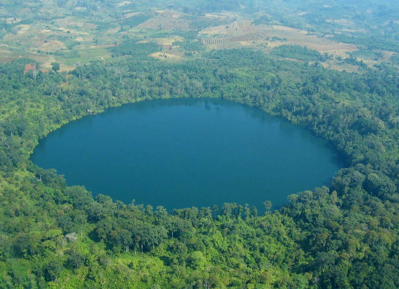
The natural heart of the province is Yeak Laom lake, an almost perfect volcanic crater filled with clear water and surrounded by jungle, formed thousands of years ago, where a swim is one of the most memorable experiences in the country. Around it, a string of waterfalls —Kachanh, Katieng, Cha Ong— tumbles through the greenery, and beyond lies the vast Virachey National Park, one of the last great wildlife refuges in Southeast Asia. All of it with the trademark red earth that stains roads, rivers and even the traveller's clothes.

But what makes Ratanakiri unique is its people. Here most of the population belongs to Indigenous highland peoples —Tampuan, Jarai, Kreung, Brao and others—, with languages, animist beliefs and traditions very different from those of the country's Khmer majority. Visiting their villages, their carved cemeteries and their markets, with respectful guides, is a glimpse into a deep and rarely seen Cambodia. This guide helps you get around a province of difficult roads and discover, respectfully, one of its most authentic corners.

📖 History of Ratanakiri

For centuries Ratanakiri was a frontier territory inhabited by Indigenous highland peoples (the Khmer Loeu: Tampuan, Jarai, Kreung, Brao and others), animists closely tied to the forest, living on the margins of the lowland Khmer kingdoms. Its remoteness made it a key setting in the 20th century: Vietnamese communists operated in the area from the 1940s, and in the mid-1960s the Khmer Rouge leadership, with Pol Pot, set up its insurgent base here, drawing support from minorities who resented the central government. Between 1969 and 1970, the region suffered heavy US bombing aimed at Vietnamese sanctuaries, and in 1970 it fell under Khmer Rouge control. After decades of war and isolation, peace slowly brought nature and cultural tourism, but also pressure from deforestation, mining and plantations on Indigenous lands. The full story is on our history page.

Read the full history ↓

🏛️ Ratanakiri is in Northeast (mountains and jungle)

The highlands of the far northeast: hills, jungle and waterfalls, home to Cambodia's Indigenous peoples and far removed from the Khmer world of the plains.

Read the history of Northeast (mountains and jungle) →

🗺️ What to see

1
Yeak Laom crater lake
A perfect volcanic crater filled with crystal-clear water and surrounded by jungle, Ratanakiri's natural gem.
Leer más ↓
Yeak Laom lake (Boeng Yeak Laom) is Ratanakiri's star attraction and one of the most beautiful and peaceful places in Cambodia. It is a crater lake: it formed thousands of years ago in the crater of an ancient volcano, which gives it an almost perfectly circular shape, about 700 metres across and up to about 48 metres deep. Its waters are remarkably clear and blue-green, and it is entirely surrounded by dense jungle reflected on the surface, in a silence broken only by birds. The best part is that you can swim: there are small wooden jetties from which to jump into the cool, clear water, a treat after the hot, dusty red dirt roads. A loop trail of about 2-3 km circles the lake through the forest, ideal for a quiet walk among trees and butterflies. The lake is sacred to the Tampuan people, who partly manage it, and it has a community feel rather than that of a mass tourist attraction. It is about 5 km east of Banlung and very easy to reach. Getting there: by motorbike, tuk-tuk or tour from the capital (a few minutes). Best time: all year round; dry season for easy roads, but it is especially enjoyable in hot weather for swimming. Tips: bring a swimsuit, towel, insect repellent and cash for the small access fee; respect the lake's sacred character for the Tampuan community and don't leave any rubbish.
ℹ️ Distance: ~5 km east of Banlung; a few minutes by motorbike, tuk-tuk or tour · Best time to go: All year round; ideal in hot weather for swimming; dry season for the roads · Admission: Access fee ~1-3 USD (managed by the Tampuan community), 2026 (verified July 2026) · Duration: 2 to 4 hours (swim + trail)
2
Ratanakiri waterfalls (Cha Ong, Kachanh, Katieng)
A trio of jungle waterfalls near Banlung, each with its own character, for cooling off and walking.
Leer más ↓
Ratanakiri is dotted with waterfalls, and the three most visited are clustered near Banlung, easy to combine in a single day. Cha Ong waterfall (Ka Tieng, sometimes called Katieng, although there are two different ones) is the tallest and most spectacular: a drop of about 25-30 metres into a jungle amphitheatre, where you can walk behind the curtain of water among ferns and volcanic rock. It is the most dramatic, especially after the rains. Kachanh waterfall (Ka Chhang) is wider and fuller, set in jungle reached by a bridge and with good pools; and Katieng waterfall, smaller and more secluded, is a pleasant cascade surrounded by greenery, popular for swimming. All of them are a few kilometres from Banlung, along red dirt roads, and usually charge a small local access fee. Cooling off in them is one of the pleasures of Ratanakiri's heat. They are the perfect complement to Yeak Laom lake for a day in nature. Getting there: by motorbike, tuk-tuk or tour from Banlung (a few km each); sometimes with a short walk at the end. Best time: during and shortly after the rains for maximum flow; dry season for firm roads. Tips: bring cash for the access fees, shoes with good grip (slippery rocks), a swimsuit and repellent; a local driver who knows the roads will save you wrong turns.
ℹ️ Distance: Cha Ong, Kachanh and Katieng a few km from Banlung (about 6-9 km each); by motorbike, tuk-tuk or tour · Best time to go: During and shortly after the rains (maximum flow); dry season for the roads · Admission: Local fee ~1-3 USD per waterfall; return tuk-tuk ~8-12 USD, 2026 (verified July 2026) · Duration: Half a day (all three combined)
3
Indigenous peoples: Tampuan, Jarai, Kreung and Brao
Villages of the highland minorities, with their own languages, animist beliefs and unique carved cemeteries.
Leer más ↓
What makes Ratanakiri truly unique is its Indigenous population. Unlike the rest of Cambodia, most of the people here belong to the original highland peoples —the Khmer Loeu—, among them the Tampuan, Jarai, Kreung, Brao, Kavet and others, each with their own language, traditions and animist religion, based on respect for the spirits of nature and the ancestors. Getting to know their world, with respectful guides, is one of the richest experiences in the northeast. One of the most fascinating aspects of these cultures is their traditional cemeteries, especially those of the Jarai and Kreung, with wooden tombs decorated with carved sculptures (sometimes figures, elephants or effigies of the dead) and offerings, in forest clearings. Many villages keep communal houses, ancestral farming practices and customs such as the 'love huts' (where young people traditionally court) in some Kreung communities. All of this is ideally visited with Indigenous guides or community tourism projects, which ensure respect and benefits for the villages. It is essential to approach with sensitivity, without intruding or treating people as an attraction. Getting there: with guides and tours from Banlung to the surrounding villages. Best time: dry season for the roads. Tips: hire local guides (ideally from the communities themselves), ask permission before taking photos, buy crafts directly from the people and behave as a visitor, not a spectator; read up on local customs beforehand.
ℹ️ Distance: Villages spread across the province, around Banlung; visited with guides/tours · Best time to go: Dry season (Nov-Apr) for the roads · Admission: Guided visits from ~15-35 USD per person depending on the programme; hire local/community guides (verified July 2026) · Duration: Half a day to a full day
4
Virachey National Park
One of Cambodia's largest and wildest parks, deep jungle for multi-day treks.
Leer más ↓
Virachey National Park, in the far north of Ratanakiri, against the borders of Laos and Vietnam, is one of the largest and most remote parks in Cambodia and one of the last great wildlife refuges in Southeast Asia. It is a vast territory of tropical jungle, mountains, rivers and savannahs, home to remarkable biodiversity including birds, primates, gibbons and, in its most inaccessible areas, rare and endangered species. It is an adventure destination for travellers with an explorer's spirit. It is not a park for an easy or quick visit: the way to experience it is on multi-day treks with guides and rangers, organised from Banlung, heading deep into the jungle with nights in hammocks or camps, river crossings and demanding hikes. These ecotourism programmes, when well run, help fund conservation and involve local communities. The experience is tough but unforgettable: nature in an almost untouched state, far from any comfort. It is for prepared travellers with time to spare. Getting there: treks are organised from Banlung with authorised operators and guides. Best time: dry season (Nov-Apr), essential for the deep jungle. Tips: book ahead with reliable operators, be in good physical shape, bring suitable gear (strong repellent, boots, quick-dry clothing) and be ready for leeches, humidity and hard effort; don't head in without authorised guides.
ℹ️ Distance: Northern Ratanakiri, against Laos and Vietnam; access and treks organised from Banlung · Best time to go: Dry season (Nov-Apr), essential for the deep jungle · Admission: Multi-day treks from ~60-120+ USD depending on length and operator (guides, permits, food), 2026 (verified July 2026) · Duration: 2 to 4 days (or more)
5
Gem mines (sapphires and zircons)
The 'mountain of gemstones' that gives the province its name: small-scale gem mining in red earth.
Leer más ↓
The name Ratanakiri literally means 'mountain of gemstones', and that is no coincidence: the province is a traditional gem-mining area, mainly for blue sapphires and zircons, which are sought in small-scale pits dug by hand in the red earth. In some areas near Banlung (such as the Bokeo region) you can visit small-scale mining sites where prospectors, using rudimentary methods, climb down narrow shafts in search of stones. Visiting these mines (always with a guide and with proper safety precautions) offers a raw and fascinating look at one of the region's traditional economic activities and at the harsh conditions of this work. In Banlung and the surrounding area there are also people selling rough or polished gems, but be very cautious: buying gemstones from strangers is scam territory, and it is easy to overpay or end up with fakes. It is more of an experience for context and anthropological interest than a polished tourist 'attraction'. Getting there: the mining areas are around Banlung (Bokeo); visited with local guides. Best time: dry season for the roads. Tips: go with a guide, don't approach the shafts carelessly, don't buy expensive gems from street sellers (high risk of scams) and treat the subject with respect for those who work in very hard conditions.
ℹ️ Distance: Mining areas around Banlung (Bokeo region); with a local guide · Best time to go: Dry season (Nov-Apr) for the roads · Admission: Guided visits from ~10-20 USD; extreme caution when buying gems (risk of scams), 2026 (verified July 2026) · Duration: Half a day
6
The provincial capital and base for everything, with its market, frontier feel and a town lake for sunset.
Leer más ↓
Banlung, the capital of Ratanakiri, is the essential base for exploring the province and is worth a wander. It is a small, dusty town with a frontier air, red dirt streets, a bustling central market where Khmer people and members of the different Indigenous groups mingle, and a growing range of guesthouses, restaurants and agencies that organise excursions. It has no major monuments, but it does have an authentic, practical feel as a base camp. In town itself is Boeng Kansaign lake (sometimes spelled Kansen), a small town lake ringed by a promenade, restaurants and the odd stall, pleasant for a quiet sunset after a day of waterfalls and villages. Banlung market, for its part, is a good place to see local life, try food and buy regional products, including highland coffee and fruit. Banlung is where you sort out the logistics: motorbike rental, hiring guides and tuk-tuks, booking treks to Virachey. Getting there: it is the arrival point for buses from Phnom Penh and other cities. Best time: all year round as a base; dry season for getting around the province. Tips: use the town to organise your excursions with local guides, withdraw cash from its ATMs before heading to rural areas and make the most of the market and the lake to get a feel for local life.
ℹ️ Distance: Provincial capital and central base; Boeng Kansaign lake in town · Best time to go: All year round as a base; dry season for excursions · Admission: Walking around the town, market and lake is free (verified July 2026) · Duration: Base for your stay; a few hours for the town
📶I have never landed without internet. I arrive and my phone connects to the strongest network in the country I am visiting: I can say I landed, sort out transport, book tours and keep posting, at a seriously good price. I always use the Maya eSIM — check their plans by clicking the banner.See plans →Maya Mobile eSIM — turn travel mode on
What nobody tells you

💵 Prices

Tickets

TypePrice
Lago cratérico de Yeak Laom (acceso)no rate published in an official source: the lake is managed by the Tampuan community and neither Cambodia's Ministry of Tourism nor its Ministry of Environment publishes the amount. Traveller reference: 1-3 USD per person, in cash at the booth
Cascadas (Cha Ong, Kachanh, Katieng) — cada unano rate published in an official source: each waterfall's fee is charged by the family or community that manages it; traveller reference, 1-3 USD per person in cash
Visita guiada a aldeas indígenas~15-35 USD per person depending on the programme, 2026
Trekking al Parque Nacional de Virachey (varios días)no rate published in an official source: the park falls under Cambodia's Ministry of Environment, which does not publish the access fee or the permit; the trek is booked with authorised operators in Banlung, who include it in the programme price (operator reference: from 60-120 USD depending on length)
Visita a zonas de minería de gemas~10-20 USD with a guide, 2026
Banlung, mercado y lago Boeng KansaignFree
🔄 updated monthlyOfficial / reference values · double-check when buying

Activities and tours

ActivityPriceDurationOperator
Swim and trail at Yeak Laom lake~1-3 USD access, 20262 to 4 hTampuan community management; reached by motorbike/tuk-tuk/tour
Waterfall tour (Cha Ong, Kachanh, Katieng)Tuk-tuk ~8-12 USD + access fees; tour from ~15-25 USD, 2026Half a dayBanlung drivers and agencies
Guided visit to Indigenous villages and cemeteries~15-35 USD per person, 2026Half a day to a full dayLocal/community guides and responsible tourism agencies
Multi-day trek in Virachey National ParkFrom ~60-120+ USD depending on length, 20262 to 4 daysAuthorised ecotourism operators in Banlung
Gem mine visit (with a guide)~10-20 USD, 2026Half a dayLocal guides (Bokeo area)
Tour of Banlung, its market and lakeFree; food and drinks extra, 2026A few hoursSelf-guided
🔄 updated monthlyOfficial / reference values · double-check when buying

🚌 How to get there and distances

Getting around

Motorbike rental
~7-10 USD per day, 2026
DurationVariable
Notes
The most flexible way to explore the province, for experienced riders: red dirt roads, rough and dusty in the dry season, muddy in the rains. A helmet is essential; fill up before heading to remote areas
Tuk-tuk and motorbike taxi with driver
PriceReturn trip to the waterfalls ~8-12 USD; full day ~20-35 USD, 2026
DurationVariable
Notes
Very handy for the waterfall circuit and the lake if you'd rather not drive. A local driver knows the roads and the rates; agree on the itinerary and price beforehand
Tours and local guides
PriceDepends on the activity (villages, trekking, mines), 2026
DurationVariable
Notes
Essential for the indigenous villages and Virachey National Park, both for safety and for the cultural and ecological value. They can be hired through the agencies and guesthouses in Banlung
On foot around Banlung
Free, 2026
DurationVariable
Notes
The town is small: the market, the lake, restaurants, ATMs and agencies are all close by. For everything else you'll need a motorbike, a tuk-tuk or a tour
🔄 updated monthlyOfficial / reference values · double-check when buying

How to get there

RouteAirlines / operatorsAvg. priceDuration
Phnom Penh → Banlung (direct bus or minivan)Virak Buntham and other operators; many run overnight~14-18 USD, 2026~8-11 h (~580-640 km)
Phnom Penh → Banlung (private taxi)Taxis and private cars with driver~110-140 USD per car, 2026~7-9 h
Stung Treng → BanlungShared minivans~7-12 USD, 2026~2-3 h
Kratie → BanlungShared minivans (sometimes with a change in Stung Treng)~10-15 USD, 2026~4-5 h
Mondulkiri (Sen Monorom) → BanlungMinivans and connections (often with a change)~12-20 USD, 2026~5-7 h depending on the route
🔄 updated monthlyOfficial / reference values · double-check when buying

🏨 Where to stay

No exact prices: a scale from $ (budget) to $$$$$ (luxury), with 2-3 options per category.

Lodges and higher-end hotels (Banlung)
Price$$$$$
Recommended options
From ~35-80 USD a night, 2026. The top end of a rural province: comfortable hotels and lodges in or around Banlung, some by the lake or with a pool, a good base for excursions
Mid-range (guesthouses and bungalows)
Price$$$$$
Recommended options
~15-35 USD a night, 2026. Decent guesthouses and bungalows in Banlung, practical and with a good traveller vibe, many linked to agencies that organise waterfalls, village visits and treks
Budget / hostels
Price$$$$$
Recommended options
Room ~7-15 USD; dorm bed ~4-8 USD, 2026. Simple, cheap places to stay in the provincial capital, popular with backpackers exploring the northeast
Homestay and jungle camping
Price$$$$$
Recommended options
Homestay ~10-25 USD with meals; camping included on Virachey treks, 2026. Basic stays in villages or nights in hammocks as part of trekking programmes, an immersive, rustic experience

🍴 Where to eat

Cocina jemer y de barrio
Price$$$$$
Options / signature dish
Dishes ~2-5 USD, 2026. Amok, lok lak, curries, soups and rice dishes in simple Banlung restaurants, good value and full of local flavour
Restaurantes para viajeros y cafés
Price$$$$$
Options / signature dish
Dishes ~4-8 USD, 2026. A few restaurants and cafés in Banlung geared to nature tourism, with simple international food, breakfasts and local highland coffee
Mercado y comida callejera
Price$$$$$
Options / signature dish
Dishes ~1-3 USD, 2026. Banlung's central market and its stalls serve noodles, rice, skewers and regional fruit, the cheapest and most authentic way to get a taste of local life
Comida en trekkings y homestays
Price$$$$$
Options / signature dish
Included in the activity, 2026. Simple home-style Khmer meals during Virachey treks and village stays, shared with guides and the community

📖 History of Ratanakiri

Origins, formation and what the sources say.

The mountain of precious stones and its indigenous peoples

The name says it all: Ratanakiri means 'mountain of precious stones', a blend of words of Sanskrit origin (ratana, jewel) and Khmer (kiri, mountain), a nod to the sapphires and zircons that have been scraped from its red earth for generations. But long before gems gave the province its name, these hills and forests in Cambodia's far northeast, wedged against Laos and Vietnam, were already home to peoples who had lived here for centuries, perhaps millennia.

They are known as the Khmer Loeu, 'the Highland Khmer': a group of indigenous peoples (Tampuan, Jarai, Kreung, Brao, Kavet, Lun and others) who are not part of the Khmer majority of the rice paddies and cities, but belong to a highland world of their own. They have their own languages (several from language families unrelated to Khmer), animist beliefs filled with nature spirits, and ways of life based on shifting cultivation, hunting and gathering in the forest. Their cemeteries, with carved wooden tombs decorated with sculptures, are one of the most distinctive cultural expressions in the country.

For almost all of their history, these peoples lived with great autonomy, beyond the reach of the central Cambodian state. The lowland Khmer kingdoms, Angkor and its successors, had barely any presence in these remote forests, which were hard to reach and harder to govern. For the Khmer state, Ratanakiri was literally the edge of the known world: a wild frontier inhabited by 'the people from up there', a land apart that official history all but ignored. That remoteness would be both their shield for centuries and their undoing in the 20th century.

The name and the Khmer Loeu
'Ratanakiri' combines roots meaning 'jewel' and 'mountain', a reference to its gem deposits (sapphires, zircons). Most of its population is indigenous: the Khmer Loeu, or 'Highland Khmer', who include the Tampuan, Jarai, Kreung, Brao, Kavet and other groups, each with languages and cultures distinct from the Khmer majority. It is one of the most ethnically diverse provinces in Cambodia.
Source: https://en.wikipedia.org/wiki/Ratanakiri_province

A land of volcanoes, jungle and blurred borders

Ratanakiri's geography explains much of its history. It is a highland province with a volcanic past that left visible traces, such as the beautiful crater lake of Yeak Laom, formed thousands of years ago in the crater of an ancient volcano, and the distinctive fertile red earth that colours roads, rivers and crops. Large rivers, dense tropical forests and rolling hills complete a landscape of great beauty but difficult access.

That deep jungle, now partly protected by the vast Virachey National Park, was for a long time a natural barrier that kept the region isolated from the rest of Cambodia. The borders with Laos to the north and Vietnam to the east were blurred lines drawn on colonial maps, of little meaning to the indigenous peoples who moved through the forest by their own logic, far removed from modern states. When France established its protectorate over Cambodia in 1863 and folded the region into French Indochina, those borders became official, but village life carried on almost unchanged for a long time.

Being a remote, forested borderland had huge consequences in the 20th century. Precisely because it was inaccessible, isolated and had porous borders, Ratanakiri became an ideal setting for clandestine war: a place to hide, cross international borders unchecked and organise an insurgency far from the eyes of central power. The same remoteness that had preserved its indigenous peoples would drag them into the heart of one of the darkest chapters in Cambodian history.

Yeak Laom Lake, a crater thousands of years old
Yeak Laom Lake is a crater lake formed in the crater of an ancient volcano, estimated to be several thousand years old. Almost perfectly round (about 700 m across) with very clear water, it is sacred to the Tampuan people and is the province's main natural attraction. It is a visible reminder of the volcanic past that gave Ratanakiri its fertile red earth.
Source: https://en.wikipedia.org/wiki/Ratanakiri_province

Cradle of the revolution: Pol Pot, the bombs and the secret war

Few places in Cambodia carry such a heavy and little-known historical weight as Ratanakiri. It was here, in this remote province, that much of the tragedy that would devastate the whole country took root. Vietnamese communists had been operating in the area since the 1940s, taking advantage of its isolation and porous borders. And in the mid-1960s, the leadership of the Communist Party of Kampuchea, the future Khmer Rouge, chose Ratanakiri as the site of its insurgent base.

In 1963, Pol Pot and much of the communist leadership left Phnom Penh and withdrew to the northeast, setting up their headquarters in the forests of Ratanakiri. There, the guerrillas managed to win the support of the Khmer Loeu peoples, exploiting the resentment many of these minorities felt towards the central government and its policy of forced assimilation. Hundreds of highlanders joined the ranks of the Khmer Rouge, who found in the region both a refuge and a recruiting ground. Sihanouk himself said in 1969 that Ratanakiri was 'practically North Vietnamese territory'.

The United States responded to this breeding ground of insurgency with crushing violence. Between March 1969 and May 1970, the US Air Force unleashed a massive and largely secret bombing campaign over eastern Cambodia (operations such as the one known as 'Menu'), aiming to destroy Vietnamese communist sanctuaries. The bombs fell on land inhabited by indigenous communities with no part in the war: villagers fled their homes, hid in the forest and survived out in the open, often alongside the Khmer Rouge themselves. In June 1970, the central government withdrew its troops and left the region to Khmer Rouge control. Ratanakiri was thus both the cradle of the revolution that would give birth to the genocide and one of its first victims.

Ratanakiri, Pol Pot's insurgent base
In 1963, Pol Pot and much of the central committee of the Communist Party of Kampuchea left Phnom Penh to set up an insurgent base in Ratanakiri. The party headquarters moved to the province around 1966, and many Khmer Loeu joined its units. The US bombings of 1969-1970 and the central government's withdrawal in 1970 consolidated Khmer Rouge control over the region, which was key to the movement's rise.
Source: https://en.wikipedia.org/wiki/Ratanakiri_province

Ratanakiri today: nature, culture and the threats on the frontier

After the horror of the 1970s and the long decades of war, occupation and recovery that followed the fall of the Khmer Rouge in 1979, Ratanakiri slowly found its way back to peace. Its isolation lasted a long time (until just a few years ago, getting to Banlung was an odyssey along dusty tracks), but as roads improved and Cambodia opened up to the world, the province began to attract nature and culture travellers, drawn by Yeak Laom Lake, the waterfalls, the Virachey forest and, above all, the extraordinary diversity of its indigenous peoples.

Today Ratanakiri offers travellers one of the most authentic experiences in Cambodia: swimming in a volcanic crater, walking among red-earth waterfalls, heading into one of the last great forests of Southeast Asia and meeting, respectfully, living indigenous cultures that keep their languages, beliefs and traditions. Coffee and other highland crops, small-scale gem mining and a budding tourism industry make up its economy.

But the province's future is under threat. Deforestation, the spread of large plantations (rubber, cashew and others), illegal logging, mining and dam building are putting pressure on the forests and, above all, on the ancestral lands of the indigenous peoples, many of whom have seen their territory and way of life shrink. The province that was a refuge for ancient cultures and the tragic cradle of a revolution now faces a quieter but equally decisive challenge: protecting its nature and its peoples from the advance of exploitation. For the mindful traveller, exploring Ratanakiri is also a way to value, and help protect, one of the most fragile and fascinating corners of Cambodia.

Deforestation and pressure on indigenous lands
Ratanakiri faces serious environmental and social threats: deforestation, the spread of agro-industrial plantations, illegal logging, mining and hydroelectric projects are putting pressure on its forests and on the ancestral lands of the Khmer Loeu peoples. The loss of land and resources threatens both the province's biodiversity and the cultural survival of its indigenous communities.
Source: https://en.wikipedia.org/wiki/Ratanakiri_province

📚 Bibliography

  • Wikipedia (EN) — «Ratanakiri province»: https://en.wikipedia.org/wiki/Ratanakiri_province
  • Wikipedia (EN) — «Khmer Loeu»: https://en.wikipedia.org/wiki/Khmer_Loeu
  • Wikipedia (EN) — «Virachey National Park»: https://en.wikipedia.org/wiki/Virachey_National_Park
  • Wikipedia (EN) — «Operation Menu»: https://en.wikipedia.org/wiki/Operation_Menu
  • Wikipedia (EN) — «Khmer Rouge»: https://en.wikipedia.org/wiki/Khmer_Rouge
  • Wonders of Cambodia — Ratanakiri Province: https://wondersofcambodia.com/ratanakiri-province-cambodias-frontier-of-gems-culture-and-wilderness/
  • Otherwise Cambodia — Ratanakiri minorities: https://otherwise-cambodia.com/regional-info/region/minority-ratanakiri
  • Backpack Adventures — Banlung and Ratanakiri: https://www.backpackadventures.org/banlung-ratanakiri/

❓ Frequently asked questions

How do you get to Ratanakiri and how long does it take?+
You get in through Banlung, the provincial capital, about 580-640 km from Phnom Penh: 8 to 11 hours by road. There are direct buses and minivans every day (Virak Buntham and others), many of them overnight, for around 14-18 USD. There's no airport with regular service and no train. You can also get there from Stung Treng (~2-3 h), Kratie (~4-5 h) or by combining it with Mondulkiri (~5-7 h, sometimes with a change). The route from Phnom Penh is long but largely paved; it's best to set off with time to spare.
When is the best time to visit Ratanakiri?+
The best season is the dry season, from November to April, when the red dirt roads are firm and passable, which is key in a province with basic infrastructure. The waterfalls carry more water during and just after the rains (May to October/November), but in the middle of the wet season the roads turn into red mud and many journeys get tricky. The sweet spot for good access and green scenery is usually the end of the rains and the start of the dry season (November-December).
How can you visit the indigenous villages respectfully?+
Ratanakiri is home to highland indigenous peoples (Tampuan, Jarai, Kreung and Brao, among others), with their own languages and animist beliefs. Ideally, visit with local guides, preferably from the communities themselves, or through community-based tourism projects, which ensure respect and real benefits for the villages. Always ask permission before taking photos, don't treat people as an attraction, buy crafts directly from the makers and read up on local customs beforehand. The carved Jarai and Kreung cemeteries are especially sensitive: approach them with respect.
What is Yeak Laom Lake and can you swim there?+
Yeak Laom is a crater lake formed thousands of years ago in an ancient volcano, almost perfectly round (about 700 m across and up to 48 m deep), with crystal-clear water surrounded by forest. It's about 5 km from Banlung and yes, you can swim: there are wooden jetties for jumping into the cool water, and a 2-3 km trail circles it through the forest. It's sacred to the Tampuan people, who manage access (a small fee of 1-3 USD). Bring a swimsuit, a towel and insect repellent, and treat the place with respect.
Is it worth combining Ratanakiri with Mondulkiri?+
Yes, they're the two big provinces of the northeast and they complement each other: Ratanakiri stands out for Yeak Laom Lake, its waterfalls, its indigenous peoples and Virachey National Park; Mondulkiri for its hills, its ethical elephant sanctuaries and Bunong culture. Many travellers put together a circuit of a week or more covering both. Just bear in mind that the direct journey between them can be long and involve changes (5-7 hours), so plan it well and leave some margin, especially in the rainy season.
Are there ATMs and do you pay in dollars in Ratanakiri?+
Banlung has ATMs and, as everywhere in Cambodia, the US dollar is used: almost everything is priced and paid in dollars, with change under 1 USD given in riel (1 USD ≈ 4.000 riel). But outside the capital, at waterfalls, villages, mines and rural areas, there are no banks and cards aren't accepted. Withdraw enough cash in Banlung before heading out, in small notes, for tours, guides, entry fees and purchases from the communities. Don't rely on your card in this remote province.

More places in Cambodia

Siem ReapSihanoukvilleAngkor WatBanlungBattambangKampot
See every place in Cambodia →The history of Cambodia →
Sources consulted (8)
Still planning?
Explore more destinations in Cambodia
See all destinations →
Image credits
Photos from Wikimedia Commons, each under its own licence (CC BY, CC BY-SA or public domain). Open each file to see its author and licence.
Yak Loum