Viajá con Gus
HomeBrazilItaimbezinho Canyon
Itaimbezinho Canyon
🇧🇷 Brazil · South

Itaimbezinho Canyon

Jump to what you need
📌State
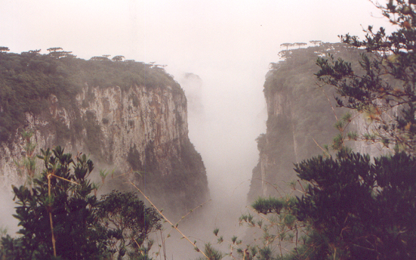
The Itaimbezinho Canyon sits at the far northeast of the state of Rio Grande do Sul, on the border with Santa Catarina, inside the Parque Nacional dos Aparados da Serra, run by ICMBio. It is the most famous canyon in southern Brazil: a colossal cleft some 5.8 km long with vertical walls up to 720 meters high, cut into the edge of the Serra Geral, where the plateau of the 'campos de altitude' (high grasslands) drops away abruptly toward the lowlands. It is one of the natural wonders of the Sul region and one of the great landscapes of Brazil
📌Service city
The base for visiting Itaimbezinho is Cambará do Sul, a small highland municipality in Rio Grande do Sul surrounded by grasslands, araucarias (the famous Paraná pines) and gaucho ranches. It is a quiet town with pousadas, rural stays, highland-cooking restaurants, travel agencies and local guides. From there you reach the Parque Nacional dos Aparados da Serra (Itaimbezinho canyon) and, very close by, the Parque Nacional da Serra Geral (Fortaleza canyon). Other gateways are Praia Grande, on the Santa Catarina side (at the foot of the range), and larger towns such as Gramado and Canela, or Porto Alegre, which has the region's main airport
📌Best time to go
The canyon can be visited all year, but every season has its own character. Autumn (March to May) and spring (September to November) usually offer the best balance: settled days, good visibility and pleasant temperatures. Winter (June to August) is cold, with freezing nights, frost, mist and even the occasional snowfall on the high grasslands; it is very beautiful but demands warm clothing and carries the risk of fog blanketing the canyon. Summer (December to February) is warmer but brings frequent afternoon rain. The key in any season is visibility: fog can 'swallow' the canyon completely, so go early, on clear days, and leave yourself some flexibility with dates. Waterfalls such as the Véu de Noiva look fuller after rain
📌Suggested days
Two days is enough to walk the rim trails of Itaimbezinho (Trilha do Vértice and Trilha do Cotovelo) in the Parque Nacional dos Aparados da Serra and, the next day, see the Fortaleza canyon in the Parque Nacional da Serra Geral, with its imposing lookout and the Cascata do Tigre Preto. With 3 to 4 days you add more trails, walks across the high grasslands and araucarias, trips to the region's waterfalls, the town of Cambará do Sul and, for the more adventurous, the descent to the canyon floor (Trilha do Rio do Boi, from Praia Grande, guide only). Leave yourself some slack in case a day dawns in thick fog
💱 BRL exchange rate
Loading rate…
🌤️ Weather in Itaimbezinho Canyon
Loading weather…

Some landscapes look painted to leave anyone speechless, and Itaimbezinho Canyon is one of them. At the edge of the Serra Geral, where the gaúcho plateau ends and the land falls away all at once, a gigantic cleft opens up nearly six kilometers long with vertical walls that in places exceed 700 meters. Streams and waterfalls run below, dropping into the void; above stretch the high grasslands dotted with araucarias, the ancient pines that are a symbol of southern Brazil. All of it is protected inside the Parque Nacional dos Aparados da Serra, on the border between Rio Grande do Sul and Santa Catarina.

Itaimbezinho is not 'conquered' in one particular way: it is contemplated. From the rim, trails lead to lookouts where the canyon opens like a vertiginous amphitheater, with the Véu de Noiva waterfall spilling down the wall and vultures and other birds gliding on the air currents. Anyone after adventure can descend to the floor on the Trilha do Rio do Boi, a demanding walk between sheer walls that is done with a guide only. And its sibling waits nearby: the Fortaleza canyon, with one of the most striking lookouts in all of Brazil. The base for everything is Cambará do Sul, a highland town with a gaucho feel, cold and quiet, surrounded by ranches and araucarias.

This guide takes a practical, warm look at how to see Itaimbezinho and its region: which trails to walk and which need a guide, how to get there from Cambará do Sul, when to go to dodge the fog, what to bring for the cold and the wind of the high grasslands, and what other wonders —the Fortaleza canyon, the waterfalls, sunrises among araucarias— are worth adding. It is one of the most overwhelming corners of southern Brazil, still far from mass tourism, ideal for anyone after big nature and silence.

📖 History of Itaimbezinho Canyon

The name 'Itaimbezinho' comes from the Tupi-Guarani 'itaimbé', usually translated as 'sharp stone' or 'crag cut sheer', with the Portuguese diminutive '-zinho': the 'little sharp stone', a nod to the canyon's vertical walls. Long before the parks, these highlands were crossed by Indigenous peoples and, later, by tropeiros and gauchos who drove cattle between the range and the coast through the passes of the Serra Geral. The canyon began earning its fame in the first half of the 20th century thanks to naturalists and hikers; the best remembered is the Jesuit priest and botanist Balduíno Rambo, who traveled and wrote about the high grasslands of the south. To protect this unique landscape —the aparados (cut edges) of the Serra Geral, its canyons, its araucarias and its high-altitude flora— the Brazilian government created the Parque Nacional dos Aparados da Serra in 1959, one of the country's first national parks. Decades later, in 1992, the neighboring Parque Nacional da Serra Geral was created, protecting other canyons such as Fortaleza and Malacara. Today both parks are run by ICMBio and are among the great natural icons of southern Brazil. The full story is on our history page.

Read the full history ↓

🏛️ Itaimbezinho Canyon is in Rio Grande do Sul

Brazil's southernmost state: a disputed frontier of the Pampa and of the Guaraní Jesuit missions, cradle of the gaúcho of mate and churrasco. Land of the Farroupilha Revolution and of Garibaldi, of the German and Italian immigration of the Serra Gaúcha, of wine and of the spectacular canyons of Cambará do Sul.

Read the history of Rio Grande do Sul →

🗺️ What to see

1
Trilha do Vértice (Itaimbezinho lookout and Véu de Noiva)
The easiest and most panoramic trail at the canyon: it leads to the 'vértice' lookouts and to the view of the Véu de Noiva waterfall dropping into the abyss.
The Trilha do Vértice is the most accessible and popular walk in the Parque Nacional dos Aparados da Serra, ideal for anyone who wants to look out over Itaimbezinho without a demanding hike. It is a short trail (a little over 1.2 km, there and back) and easy in grade, largely on boardwalks, running along the canyon rim to two main lookouts. From them you take in the huge gorge of Itaimbezinho opening up in a 'V' or an amphitheater, with its vertical walls dropping hundreds of meters toward the forested floor. The star of this trail is the Véu de Noiva (Bridal Veil) waterfall, a drop of water that spills down the canyon wall and that, on days with good flow, looks like a white ribbon floating in the void. From another lookout you also see the Cascata das Andorinhas. The sense of height and immensity from the rim is overwhelming; respect the railings and do not go near the edge, because the walls are vertical and the wind blows hard. Getting there: the trail starts from the visitor area of the Parque Nacional dos Aparados da Serra, some 18 km from Cambará do Sul along a rural road (partly unpaved). You get there by car, on a tour or with a guide/transfer from town. You have to pay park admission and register; check hours and whether you need to book online through the ICMBio or concession system. Best time and tips: go early in the morning and on clear days, because fog tends to rise and blanket the canyon (if it closes in, you may see nothing at all). Morning sun lights the walls well. Bring warm layers and a windproof (it is cold and windy up there), sunscreen, water and comfortable shoes. The waterfalls look fuller after rain.
ℹ️ Distance: Parque Nacional dos Aparados da Serra, some 18 km from Cambará do Sul (car, transfer or tour) · Best time to go: Early morning and clear days (fog blankets the canyon) · Admission: R$ 107 per person (full price; R$ 75 for over-60s) (source: official Urbia site urbiaparques.com.br, verified July 2026); the ticket works for both parks, up to 3 visits in 7 days · Duration: 1 to 2 hours
2
Trilha do Cotovelo (lookout over the canyon's 'elbow')
The longest rim trail at Itaimbezinho, out to the Cotovelo lookout, with one of the widest views of the whole gorge.
The Trilha do Cotovelo is the other great rim trail at Itaimbezinho, somewhat longer and more demanding than the Vértice, but rewarded with one of the most complete panoramas of the canyon. It runs about 6 km there and back and is easy to moderate in grade, with no big climbs, following the canyon edge across the high grasslands. The destination is the Mirante do Cotovelo, so named because the canyon takes a turn there, an 'elbow', which lets you see much of its winding course. From the Cotovelo lookout the view takes in the immense gorge of Itaimbezinho in all its depth, with the vertical walls, the vegetation on the floor and, in the distance, the point where the canyon opens out toward the lowlands of Santa Catarina. It is a perfect place to feel the sheer scale of the landscape and, with luck, watch raptors gliding on the updrafts. The path, out in the open, also lets you take in the flora of the high grasslands. Getting there: it starts from the same visitor area of the Parque Nacional dos Aparados da Serra (some 18 km from Cambará do Sul). It combines very well with the Trilha do Vértice on a single park visit. You get there by car, transfer or tour, paying admission and registering. Best time and tips: as with the rest of the park, go early and with clear skies to avoid the fog. Since it is a longer trail out in the open, bring water, sunscreen, a hat, a windproof and warm layers, because the wind and the altitude cold are noticeable. Hiking shoes recommended. Allow enough time to do both trails without rushing.
ℹ️ Distance: Parque Nacional dos Aparados da Serra, some 18 km from Cambará do Sul · Best time to go: Early morning and clear days; avoid days of thick fog · Admission: Included in admission to the Parque Nacional dos Aparados da Serra, R$ 107 full price (source: official Urbia site, verified July 2026) · Duration: 2 to 3 hours
3
Véu de Noiva waterfall
The most famous waterfall at Itaimbezinho, dropping down the canyon wall like a white veil suspended in the void.
The Véu de Noiva (Bridal Veil) waterfall is one of the most photographed images of Itaimbezinho and a symbol of the Parque Nacional dos Aparados da Serra. It is a drop of water that spills down the vertical wall of the canyon, falling hundreds of meters to the floor. When the flow is good, the wind atomizes the water into that white, vaporous trail that gives it its name, like a veil floating in the air against the walls. The waterfall is not visited close up from above: you take it in from the lookouts on the Trilha do Vértice, on the canyon rim, which is precisely where its fall is best appreciated against the drop. Watching it spill down the wall, with the immensity of the canyon behind, is one of the most memorable moments of the visit. Nearby you can also see the Cascata das Andorinhas. Getting there: via the Trilha do Vértice, in the visitor area of the Parque Nacional dos Aparados da Serra (some 18 km from Cambará do Sul). It requires no extra walking beyond the trail itself. Best time and tips: the flow depends heavily on rainfall, so after wet spells it looks far more imposing; in dry periods it can shrink considerably. As always at the canyon, go early and in good weather to avoid the fog, which can hide the waterfall entirely. Hold on to your camera or phone against the wind at the rim.
ℹ️ Distance: Lookout on the Trilha do Vértice, Parque Nacional dos Aparados da Serra · Best time to go: After rain (more water); a clear morning to see it without fog · Admission: Included in admission to the Parque Nacional dos Aparados da Serra, R$ 107 full price (source: official Urbia site, verified July 2026) · Duration: Included in the Trilha do Vértice
4
Fortaleza Canyon (Parque Nacional da Serra Geral)
The most imposing canyon in the region: a dizzying lookout over walls hundreds of meters high, with views that on clear days reach the sea.
The Cânion Fortaleza is, for many, the most striking lookout in the whole southern canyon region, and it is protected in the neighboring Parque Nacional da Serra Geral. It is a wider, more open canyon than Itaimbezinho, with vertical walls hundreds of meters high spread out in a gigantic amphitheater. From the main lookout, leaning over the edge produces a magnificent vertigo: the plateau of high grasslands ends all at once and the view drops to the floor and stretches, on very clear days, as far as the Santa Catarina coast and the ocean in the distance. The visit is done on easy to moderate rim trails leading to the various Fortaleza lookouts. Along the way you cross high grasslands and can see the Cascata do Tigre Preto, another drop that falls into the void down the canyon wall. Late-afternoon light on the walls is especially beautiful, though you have to keep the park's hours in mind. Getting there: the access to Fortaleza canyon is some 23 km from Cambará do Sul along a rural road (partly unpaved). You get there by car, transfer or tour, and you pay admission to the Parque Nacional da Serra Geral, registering at the entrance. Check hours and any online booking requirements. Best time and tips: as at every canyon here, the enemy is fog, so go on clear days and with some flexibility on timing. Bring warm layers, a windproof, sunscreen, water and comfortable shoes. It is a perfect outing to pair with Itaimbezinho on a trip of two or more days.
ℹ️ Distance: Parque Nacional da Serra Geral, some 23 km from Cambará do Sul (car, transfer or tour) · Best time to go: Clear days; with very clear skies the view reaches the sea · Admission: R$ 107 per person (full price; R$ 75 for over-60s) (source: official Urbia site, verified July 2026). The same Aparados da Serra ticket works for Serra Geral/Fortaleza (3 visits in 7 days) · Duration: Half a day
5
Trilha do Rio do Boi (descent to the canyon floor)
The great adventure of Itaimbezinho: a demanding walk along the canyon floor, between walls hundreds of meters high, with a guide only.
The Trilha do Rio do Boi is the most adventurous experience at Itaimbezinho and one of the most impressive walks in southern Brazil. Instead of looking at the canyon from above, this trail runs through it, along its floor, following the bed of the Rio do Boi between the vertical walls that rise hundreds of meters on both sides. Walking the riverbed, with those colossal walls overhead, gives a completely different and far more intimate sense of the scale of Itaimbezinho. It is a long, demanding trail (around 14 to 16 km there and back, depending on how far you go), hard in grade: you have to cross the river several times, walk over rocks and boulders, and it takes good fitness and a full day. For safety, you must be accompanied by an accredited guide: the river can rise fast with rain and the terrain is challenging. You cannot do it on your own. Getting there: access to the Trilha do Rio do Boi is from the foot of the range, on the Santa Catarina side, from the town of Praia Grande (not from the rim, in Cambará do Sul). The usual approach is to book it with a guide or agency, who arranges the meeting point and the transport. Best time and tips: it only runs in good weather and when the river level allows; if there is any risk of rain or a rise in the water, guides call it off. Bring footwear you do not mind soaking, a change of clothes, plenty of water, food, sunscreen and, above all, always do it with an accredited guide. It is not for anyone after a gentle stroll: it is a serious but unforgettable day of trekking.
ℹ️ Distance: Access from Praia Grande (Santa Catarina), at the foot of the range · Best time to go: Settled days with no risk of the river rising; guide compulsory · Admission: Trail with compulsory guide: from R$ 130 per person for the guide + R$ 107 park admission; full packages from R$ 280–400 (range based on Mala de Aventuras and local operators, verified July 2026) · Duration: Full day (demanding trail, around 9 h)
6
Cambará do Sul (base town, araucarias and high grasslands)
The quiet highland town that serves as the base for the canyons, surrounded by araucarias, gaucho ranches and high grasslands.
Cambará do Sul is the logistical and human heart of a canyon visit: a small highland municipality in Rio Grande do Sul, more than 1,000 meters up, surrounded by high grasslands, araucaria forests and ranches with a gaucho tradition. It is a quiet town of calm streets, where you breathe the cold, clean air of the range and feel the gaucho culture of the south: mate (chimarrão), churrasco, boots and ponchos, country life. Beyond serving as the base for Itaimbezinho and Fortaleza canyon, Cambará do Sul invites you to explore its surroundings: walks across the high grasslands dotted with araucarias (the Paraná pines, symbol of the south), visits to ranches and rural estates, waterfalls nearby and spots for watching sunrises and sunsets through the mist. In winter, frost paints the fields white, and in some years snow falls, something rare in Brazil that draws visitors. The town has charming pousadas and rural stays, highland-cooking restaurants (soups, churrasco, homemade sweets, cheeses), travel agencies and guides who organize outings to the canyons and the trails. It is the ideal place to rest, eat well and warm up after a day of walking. Getting there: you reach Cambará do Sul by car or bus from Porto Alegre, Gramado/Canela or Praia Grande. Best time: all year; winter is cold and magical (frost, possible snow), autumn and spring are the most settled. Tips: book accommodation early in high season and on holidays; always bring warm layers (the nights are cold even in summer) and use the local guides to organize the canyons.
ℹ️ Distance: Base town; some 18-23 km from the parks (rural roads) · Best time to go: All year; winter cold and magical, autumn/spring more settled · Admission: Free to walk around town; ranch and canyon outings are booked (from R$ 250–290 per person for the two-canyon combo, range based on local agencies, verified July 2026) · Duration: A base for 2 to 4 days
7
Cascata do Tigre Preto (Fortaleza canyon)
A waterfall that plunges down the wall of Fortaleza canyon, visible from its lookouts.
The Cascata do Tigre Preto is one of the great attractions of Fortaleza canyon, in the Parque Nacional da Serra Geral. It is a very tall waterfall that spills down the vertical wall of the canyon, dropping toward the floor in a spectacular fall you take in from the lookouts along the route. Together with the immensity of the canyon, it is one of the images that best sums up the force of the Serra Geral landscape. The waterfall is seen from the rim, along the lookout trail at Fortaleza canyon; you cannot reach its base from above. Watching it fall into the void, with the amphitheater of walls behind and, on clear days, the far-off Santa Catarina coast, is one of the high points of a park visit. Getting there: it is part of the Fortaleza canyon route, in the Parque Nacional da Serra Geral, some 23 km from Cambará do Sul. You get there by car, transfer or tour, paying park admission. Best time and tips: the flow depends on rainfall, so it looks more imposing in wet periods. As across the region, go on clear days to avoid the fog. Bring warm layers, a windproof and water, and combine it with the Fortaleza lookouts on the same outing.
ℹ️ Distance: Fortaleza canyon, Parque Nacional da Serra Geral (some 23 km from Cambará do Sul) · Best time to go: After rain (more water); clear days · Admission: Included in admission to the Parque Nacional da Serra Geral, R$ 107 full price (source: official Urbia site, verified July 2026) · Duration: Included in the Fortaleza canyon visit
8
High grasslands and araucaria forests
The unique landscape of the plateau: high-altitude grassland dotted with araucarias, the ancient pines that symbolize southern Brazil.
Before you lean out over the canyons, the first thing that wins you over in this region is the plateau landscape: the campos de altitude, huge grasslands spreading out above 1,000 meters, dotted with araucarias (Araucaria angustifolia), the majestic Paraná pines with umbrella-shaped crowns that are the plant emblem of southern Brazil. This combination of grassland and araucaria forest is part of the Mata Atlântica biome and is a fragile ecosystem of great value. Crossing these grasslands —on the access roads to the parks, on ranches or on guided outings— is an experience in itself: golden light over the grass, araucarias cut out against the sky, the herds, the morning mist and, in winter, the frost whitening the ground. It is a serene landscape, gaucho in feel, very different from the tropical image usually associated with Brazil. The high-altitude flora and fauna include species adapted to the cold and raptors that glide over the canyons. Many pousadas and ranches in the area let you enjoy this setting up close, with horse riding, walks and time by the fire. Getting there: the high grasslands are crossed on the roads between Cambará do Sul and the parks, and enjoyed on ranches and outings across the region. Best time: all year; winter, with frost and mist, is especially photogenic; sunrise and sunset give the best light. Tips: bring warm layers (the altitude cold catches people out), respect the grasslands and the araucarias (a protected ecosystem) and enjoy the silence and the clean skies for stargazing.
ℹ️ Distance: The Serra plateau around Cambará do Sul and the parks · Best time to go: All year; winter with frost and misty sunrises · Admission: Free on public roads; horse riding and ranch outings are booked (R$ 80–200 per person, range based on rural operators, verified July 2026) · Duration: Variable (outings and drives)
9
Praia Grande (Santa Catarina) and the foot of the range
The gateway on the Santa Catarina side, at the foot of the walls, the base for the Trilha do Rio do Boi and for waterfalls.
Praia Grande is a municipality in southern Santa Catarina at the foot of the Serra Geral, right below the great canyons. Unlike Cambará do Sul, which is up on the plateau, Praia Grande is down in the lowlands, which gives it a warmer climate and an impressive view of the Serra walls rising above the town. It is the other great gateway to the canyon region. Its biggest logistical draw is that the Trilha do Rio do Boi, the descent along the floor of Itaimbezinho, starts here. But Praia Grande is also an adventure destination in its own right: around it there are waterfalls, rivers, walls for climbing and abseiling, and cycling routes and walks through the lush vegetation at the foot of the range. The contrast between the cold plateau of Cambará and the warm green of Praia Grande sums up the geography of the Serra Geral. Getting there: Praia Grande connects by road with the Santa Catarina coast and, over the range roads, with Cambará do Sul (a scenic drive). You get there by car or bus. Best time: for the Trilha do Rio do Boi, settled days with no risk of the river rising; for the waterfalls, all year (more water after rain). Tips: if you want to combine Itaimbezinho 'from above' (Cambará) and 'from inside' (Rio do Boi), Praia Grande is the base for the descent; hire an accredited guide for the Rio do Boi.
ℹ️ Distance: Southern Santa Catarina, at the foot of the range (connected to Cambará do Sul over the Serra) · Best time to go: All year; for the Rio do Boi, settled days with no risk of the river rising · Admission: Free to walk around town; trails and adventure activities are booked (Rio do Boi from R$ 130 guide + admission; waterfalls R$ 20–50, range based on local operators, verified July 2026) · Duration: Half a day to a day (or a base for the Rio do Boi)
10
Waterfalls in the region (Passo de Santa Bárbara and around)
A constellation of waterfalls across the grasslands and woods around Cambará do Sul, ideal to add to your visit.
Besides the canyons, the region around Cambará do Sul and the Serra Geral is scattered with waterfalls worth seeing if you are staying several days. Between the high grasslands, the araucaria woods and the rivers that later plunge down the canyons, there are numerous falls of different sizes, many on rural properties or in natural areas offering trails and swimming holes on warm days. These waterfall outings are a lovely way to get to know the surroundings beyond the canyon rim: gentle walks through the vegetation, river and forest scenery, and quiet corners to rest. Some are visited on ranches or private attractions with a small admission fee; others are more freely accessible. Ask in town or with the guides which ones are accessible depending on the season and the state of the roads. Getting there: most are around Cambará do Sul and along the road toward Praia Grande, reachable by car, transfer or tour. Best time: after rain they look fuller; warm days invite a swim. Tips: ask locally about the state of the roads (many are dirt), bring proper footwear, insect repellent and, if you plan to swim, a change of clothes. They are an excellent complement to a trip of 3 or 4 days in the region.
ℹ️ Distance: Around Cambará do Sul and along the road toward Praia Grande (rural roads) · Best time to go: After rain (more water); warm days for a swim · Admission: Varies: some free, others with a small fee on ranches (R$ 20–50 per person, range based on local tourism blogs, verified July 2026) · Duration: Half a day
Advertisements
What nobody tells you

💵 Prices

Tickets

TypePrice
Parque Nacional dos Aparados da Serra (Itaimbezinho canyon, Vértice and Cotovelo trails)R$ 107 per person (full price; R$ 75 for over-60s; free up to age 6) (source: official Urbia sales at canionsverdes.urbiapass.com.br, verified July 2026). The ticket works for both parks and allows up to 3 visits in 7 days
Parque Nacional da Serra Geral (Fortaleza canyon, Cascata do Tigre Preto)Covered by the same R$ 107 full-price ticket (source: official Urbia site, verified July 2026); Fortaleza and Itaimbezinho must be visited on days within the same 7-day window
Parking at the parksR$ 20 car, R$ 13 motorbike, R$ 34 motorhome/van, per park (source: official Urbia Cânions Verdes sales and Guia Aparados da Serra, verified July 2026)
Trilha do Rio do Boi (descent to the canyon floor, guide compulsory)From R$ 130 per person for the guide + park admission (R$ 107); full packages with guide, insurance, photos and a snack R$ 280–400 (range based on Mala de Aventuras and local operators, verified July 2026)
Waterfalls and attractions on private ranches in the regionR$ 20–50 per person depending on the attraction (range based on local tourism blogs, verified July 2026); some are free to access
Walking around Cambará do Sul and the high grasslands (public roads)Free (open access)
🔄 updated monthlyOfficial / reference values · double-check when buying

Activities and tours

ActivityPriceDurationOperator
Guided tour to Itaimbezinho canyon (Vértice and Cotovelo trails) with transferR$ 150–250 per person excluding admission; the two-canyon combo usually runs around R$ 250–290 (range based on Cambará do Sul agencies, verified July 2026)Half a dayCambará do Sul agencies and guides
Guided tour to Fortaleza canyon (lookouts and Cascata do Tigre Preto) with transferR$ 150–250 per person excluding admission; cheaper combined with Itaimbezinho (range based on local agencies, verified July 2026)Half a dayCambará do Sul agencies and guides
Trilha do Rio do Boi (descent along the canyon floor, guide compulsory)From R$ 130 per person for the guide + park admission; full packages R$ 280–400 (range based on Mala de Aventuras and local operators, verified July 2026)Full day (around 9 h)Accredited guides out of Praia Grande (max. 7 people per guide)
Two-park combo (Itaimbezinho + Fortaleza) with transfer from CambaráR$ 250–290 per person (min. 2 passengers, excluding admission; range based on Cambará do Sul travel agencies, verified July 2026); more expensive if booked through your pousadaA full day or two half daysCambará do Sul travel agencies
Ranch, high-grassland and araucaria outing (on horseback or on foot)R$ 80–200 per person depending on length (range based on ranches and rural operators, verified July 2026)Half a dayRanches and rural operators
Sunrise/sunset photo outing among araucarias and mistR$ 100–250 per person depending on the service (range based on local guides, verified July 2026)A few hoursLocal guides and pousadas
Visit to waterfalls in the regionR$ 50–150 per person for the guided outing; admission R$ 20–50 (range based on local agencies, verified July 2026)Half a dayCambará do Sul / Praia Grande agencies and guides
Adventure tourism in Praia Grande (abseiling, waterfalls, cycling)R$ 120–300 per person depending on the activity (range based on Praia Grande adventure operators, verified July 2026)Half a day to a dayPraia Grande adventure operators
🔄 updated monthlyOfficial / reference values · double-check when buying
Advertisements

🚌 How to get there and distances

Getting around

ModePriceDurationNotes
Own or rental carRental from R$ 120–200 a day in Porto Alegre (range based on aggregators such as Rentcars, verified July 2026); fuel separate; parking at the parks R$ 20VariableThe most comfortable and flexible way to move between Cambará do Sul and the parks. Part of the roads to the parks are dirt; drive carefully, especially in rain or fog
Transfer / tourist van from Cambará do SulR$ 150–290 per person depending on the outing (min. 2 passengers; range based on local agencies, verified July 2026)VariableServices run by agencies and pousadas taking you to the parks and trails. Ideal if you do not drive; a guide is usually included
Organized tour (with guide)R$ 150–290 per person for the canyon combo; Rio do Boi from R$ 130 + admission (range based on local agencies, verified July 2026)Half a day to a full dayThe most practical option for seeing the canyons, the waterfalls and the high grasslands without worrying about the roads. Recommended for the Trilha do Rio do Boi (guide compulsory)
Taxi / local appR$ 30–80 for short hops in town (range based on local forums, verified July 2026); arrange in advanceVariableLimited availability in a small town like Cambará do Sul; arrange it in advance. Useful for short hops within town
Intercity busR$ 30–70 depending on where you start —Porto Alegre, the serra, the coast— (range based on regional companies, verified July 2026)VariableIt connects Cambará do Sul with Porto Alegre, the serra (Gramado/Canela) and Praia Grande, but with limited frequency. It does not reach the parks: for the canyons you need a car, a transfer or a tour
🔄 updated monthlyOfficial / reference values · double-check when buying

How to get there

RouteAirlines / operatorsAvg. priceDuration
Porto Alegre (Salgado Filho airport, POA) → Cambará do Sul (by car)Own or rental car; route over the serraFuel/tolls R$ 120–180 one way; rental from R$ 120/day (range based on aggregators and travel forums, verified July 2026)Approx. 3.5 to 4.5 hours (about 190 km)
Gramado / Canela → Cambará do Sul (by car or tour)Own car or tours from the Serra GaúchaFull-day tours from R$ 350–500 per person (range based on Serra Gaúcha agencies, verified July 2026); by car, fuel separateApprox. 2 to 2.5 hours
Praia Grande (Santa Catarina) → Cambará do Sul (over the Serra)Own car or transfer; scenic Serra roadPrivate transfer R$ 150–300 each way (range based on local agencies and forums, verified July 2026)Approx. 1 to 1.5 hours depending on the state of the road
Long-distance bus to Cambará do SulCitral, Santo Anjo and regional companiesR$ 40–90 depending on where you start —Porto Alegre, the serra, the coast— (range based on regional bus companies, verified July 2026)Depends on where you start (Porto Alegre, the serra, the coast)
Flights to Porto Alegre (POA) from other Brazilian citiesLATAM, GOL, AzulFrom R$ 300–700 one way depending on origin and how far ahead you book (range based on flight search engines, verified July 2026)Depends on where you start (then the overland leg to Cambará do Sul)
🔄 updated monthlyOfficial / reference values · double-check when buying

🏨 Where to stay

No exact prices: a scale from $ (budget) to $$$$$ (luxury), with 2-3 options per category.

CategoryPriceRecommended options
Characterful country pousadas and hotels$$$$$R$ 330–532 a night (range based on Booking.com for highland pousadas and country hotels in and around Cambará do Sul, verified July 2026), many on ranches among araucarias and high grasslands, with a fireplace, regional cooking and views. For holidays and high season, book in advance
Mid-range pousadas and stays in Cambará do Sul$$$$$R$ 210–330 a night (range based on Booking.com for mid-range pousadas and stays in town, verified July 2026), a few minutes from the park access roads, with a highland breakfast. The most practical base for seeing both canyons (e.g. Cânions de Cambará from ~R$ 191)
Stays in Praia Grande (Santa Catarina)$$$$$R$ 180–350 a night (range based on Booking.com for pousadas and hotels in Praia Grande, verified July 2026), at the foot of the range, an ideal base for the Trilha do Rio do Boi and adventure activities. A good alternative for taking on the canyons 'from below'
Budget / hostels and campsites$$$$$R$ 125–180 a night (range based on Booking.com/Hostelworld for hostels, simple stays and campsites in Cambará do Sul and Praia Grande, verified July 2026; e.g. Pousada & Hostel Cape Town from ~R$ 125). Check the heating and bedding, given the highland cold, especially in winter

🍴 Where to eat

TypePriceOptions / signature dish
Highland and gaucho cooking (churrasco, soups, stews)$$$$$R$ 50–110 per person (range based on Tripadvisor for highland-cooking restaurants in Cambará do Sul, verified July 2026), with gaucho churrasco, hot soups, stews and country dishes. Cozy, rustic atmosphere
Cafés coloniais and homemade sweets$$$$$R$ 50–90 per person (range based on Tripadvisor for the classic Serra Gaúcha 'café colonial', verified July 2026), generous spreads of breads, cheeses, cured meats, homemade sweets, jams and cakes, an inheritance from the immigrants
Budget restaurants and lanchonetes$$$$$R$ 25–50 per person (range based on Tripadvisor and local forums, verified July 2026), lanchonetes, pay-by-weight food and simple restaurants, practical and cheap for a quick lunch before or after the canyon outings
Regional products (cheeses, wines, preserves)$$$$$R$ 15–60 per item (range based on local shops and producers, verified July 2026), artisanal cheeses, cured meats, honeys, preserves and Serra Gaúcha wines, good to try and to take home
Advertisements

📖 History of Itaimbezinho Canyon

Origins, formation and what the sources say.

The origin of the name: 'Itaimbezinho', the little sharp stone

The name 'Itaimbezinho' has Indigenous roots and describes with remarkable accuracy what travelers see when they lean out over the canyon. It comes from the Tupi-Guarani 'itaimbé', a compound of 'itá' (stone) and a term associated with something sharpened or cut sheer, usually translated as 'sharp stone', 'cutting crag' or 'rock wall cut sheer'. To that Indigenous word the Portuguese diminutive suffix '-zinho' was added, so 'Itaimbezinho' comes out as something like 'the little sharp stone' or 'the little crag cut sheer'.

The name points directly at the most striking feature of the place: the canyon's vertical walls, cut almost sheer, dropping hundreds of meters from the edge of the plateau. It is one of many place names in southern Brazil that carry the mark of Indigenous languages, in this case describing the landscape with the precision of people who knew it long before the Europeans arrived.

The region is part of what is called the 'Aparados da Serra'. 'Aparados' means, in Portuguese, 'trimmed' or 'cut', and describes the edge of the Serra Geral, which looks sliced off in one go: the plateau ends abruptly in a vertical escarpment, as if the tableland had been 'trimmed' with a knife. That image of an edge cut sheer is precisely what named both the canyons and the national park that protects them.

The Tupi-Guarani meaning of 'itaimbé'
The most widespread etymology derives 'Itaimbezinho' from the Tupi-Guarani 'itaimbé', usually translated as 'sharp stone' or 'crag cut sheer', in reference to the canyon's vertical walls, with the Portuguese diminutive '-zinho'. Exact translations of Tupi-Guarani place names can vary between sources, so they are best taken as approximations.
Source: https://pt.wikipedia.org/wiki/Itaimbezinho
The sense of 'Aparados da Serra'
The term 'Aparados' that names the region and the park refers to the edge of the Serra Geral being 'trimmed' or 'cut' abruptly, forming the vertical escarpments where the canyons open up. It is a geographical description of the relief rather than an Indigenous place name.
Source: https://pt.wikipedia.org/wiki/Parque_Nacional_de_Aparados_da_Serra

The geology: how the Serra Geral canyons were made

The canyons of the Aparados da Serra are, above all, the work of deep geology and of time. Their story goes back hundreds of millions of years, when the region was part of the supercontinent Gondwana. Back then, vast stretches of southern South America and southern Africa were covered by sand deserts, whose sediments, compacted, gave rise to the sandstones that today form the base of these landscapes (the Botucatu Formation).

Later, around 130 to 135 million years ago, during the break-up of Gondwana and the opening of the Atlantic Ocean, gigantic volcanic eruptions took place. Immense flows of basaltic lava covered the region in successive layers, one on top of another, forming a thick package of volcanic rock known as the Serra Geral Formation. Those basalt layers, laid over the older sandstones, are what make up the plateau and the canyon walls today.

Over millions of years, erosion —rainwater, rivers, wind, cycles of cold and heat— wore down and carved that basalt plateau. At the edge of the Serra Geral, where the tableland drops toward the lowlands, rivers cut deep gorges into the rock, retreating slowly inland and opening the canyons we see today: Itaimbezinho, Fortaleza, Malacara and others. The different lava layers visible in the walls are like the pages of a geological book recording those ancient eruptions. The result is one of the most spectacular sets of canyons in South America.

The volcanism of the Serra Geral Formation
The canyon walls are made up mainly of basalts of the Serra Geral Formation, produced in one of the largest volcanic events on the planet, tied to the break-up of Gondwana and the opening of the South Atlantic, roughly 130-135 million years ago. Over older sandstones (the Botucatu Formation), the lava flows stacked into layers that can be seen today in the walls.
Source: https://pt.wikipedia.org/wiki/Forma%C3%A7%C3%A3o_Serra_Geral
Erosion as the sculptor of the canyons
The canyons formed through the prolonged erosion of the edge of the basalt plateau: rivers cut gorges and the Serra Geral escarpment retreated slowly inland. The figures for the height of the walls (up to around 720 m at Itaimbezinho) and the length of the canyon (around 5.8 km) are the ones usually cited, though they can vary slightly depending on the source.
Source: https://pt.wikipedia.org/wiki/Itaimbezinho

Indigenous peoples, tropeiros and the settling of the range

Long before there were parks, roads or pousadas, the highlands of the Serra Geral were crossed by Indigenous peoples. The high grasslands and araucaria forests of southern Brazil were inhabited by Indigenous groups of the Jê tradition, associated with the culture archaeologists link to the Kaingang and Xokleng peoples, alongside a wider presence of Guarani-speaking peoples in the region. For them, the araucaria was a fundamental resource: the pinhão, the seed of the Paraná pine, was a staple food, and the araucaria forests set the rhythm of life on the plateau.

With the arrival of the Europeans and the spread of ranching in the south, these highlands were absorbed into the routes of the tropeiros, the drovers who moved herds —mostly mules and cattle— between the breeding regions of the south and the markets of the interior and the southeast of Brazil. The passes of the Serra Geral, where the plateau connects with the coastal lowlands, were key roads in that trade. The gaucho culture of the region —cattle, horses, mate, churrasco— has its roots in that history.

Permanent settlement of the Cambará do Sul area took hold with ranches devoted to raising cattle on the high grasslands, making use of the plateau's natural pastures. To that ranching base was added, in the 19th and 20th centuries, the influence of the European immigration that populated much of the Serra Gaúcha, leaving its mark on the food (the cafés coloniais, the cheeses, the cured meats) and on local customs. From that mixture came the calm, rural character of the region that today welcomes canyon visitors.

The Jê peoples and the araucaria
The high grasslands and araucaria forests of southern Brazil were inhabited by Indigenous peoples of the Jê tradition (associated with the Kaingang and Xokleng), for whom the araucaria pinhão was an essential food. The reconstruction of these prehistoric occupations rests on archaeological evidence, with nuances depending on the source.
Source: https://es.wikipedia.org/wiki/Araucaria_angustifolia
The tropeiro roads over the Serra
The passes of the Serra Geral worked as routes for the tropeiros who moved cattle between the south and other regions of Brazil, an activity that underpins the gaucho culture of the area. The specific details of the routes and dates vary depending on the regional historical sources.
Source: https://pt.wikipedia.org/wiki/Cambar%C3%A1_do_Sul

Explorers and naturalists: the canyon is 'revealed' (20th century)

Although the canyons were always there, their 'discovery' by the wider public —and by science and tourism— came only in the 20th century. Until then, Itaimbezinho was known above all to people in the region, the ranchers and the trackers who worked the high grasslands. Its monumental scale and its beauty grew in fame as naturalists, hikers and scientists began to explore and write about the edge of the Serra Geral.

Among the best-remembered figures in bringing this landscape to light is the Jesuit priest Balduíno Rambo (1905-1961), a gaúcho priest, naturalist and botanist, author of foundational works on the nature of southern Brazil such as 'A Fisionomia do Rio Grande do Sul'. Rambo studied and publicized the flora and the landscapes of the high grasslands and the Serra Geral, helping the region and its araucaria forests to be recognized for their exceptional natural value.

Through the 20th century, expeditions of naturalists, geographers and mountaineers documented the canyons, their walls, their flora and their fauna. That growing body of knowledge, along with an awareness of the importance of protecting the high-altitude Mata Atlântica and the araucaria forests —then under threat from intensive logging— created the climate that would lead, at the end of the 1950s, to the creation of the first national park to safeguard Itaimbezinho and the Aparados da Serra.

The contribution of Balduíno Rambo
The Jesuit and botanist Balduíno Rambo is identified as a key figure in the study and popularization of the nature of southern Brazil, including the high grasslands and the flora of the Serra Geral. His exact role in the touristic 'revelation' of Itaimbezinho should be understood within the wider scientific appreciation of the region.
Source: https://pt.wikipedia.org/wiki/Balduino_Rambo

The creation of the Parque Nacional dos Aparados da Serra (1959)

The decisive step in protecting Itaimbezinho came in 1959, when the Brazilian government created the Parque Nacional dos Aparados da Serra. It was one of Brazil's first national parks, established at a time when the country was starting to take significant steps on nature conservation. The central aim was to preserve the extraordinary set of canyons on the edge of the Serra Geral —led by Itaimbezinho— along with the high grasslands, the araucaria forests and the rich biodiversity of the high-altitude Mata Atlântica.

The park straddles the states of Rio Grande do Sul and Santa Catarina, right on the escarpment where the plateau drops toward the lowlands. Its creation sought to halt the pressure of araucaria logging and agricultural expansion, which threatened one of the most singular landscapes in the south of the country. Over the years, the protected area gained structure for visitors: trails, lookouts, a visitor center and regulated access.

Decades later, in 1992, the neighboring Parque Nacional da Serra Geral was created, extending protection to other canyons in the region, such as Fortaleza and Malacara, which had fallen outside the boundaries of the first park. The two adjoining units today form a large conservation corridor run by ICMBio (the Chico Mendes Institute for Biodiversity Conservation). Together they protect not only the canyons but a whole high-altitude ecosystem of enormous value, and they make up one of the main ecotourism destinations in southern Brazil.

The creation dates of the two parks
The Parque Nacional dos Aparados da Serra was created in 1959, one of Brazil's first national parks, to protect the canyons on the edge of the Serra Geral. The adjoining Parque Nacional da Serra Geral was created in 1992 to safeguard other canyons in the region (such as Fortaleza). Both are today run by ICMBio.
Source: https://pt.wikipedia.org/wiki/Parque_Nacional_de_Aparados_da_Serra

Ecotourism, conservation and the Cambará do Sul of today

With the national parks established, the Cambará do Sul region gradually turned from a quiet ranching enclave on the plateau into one of the great ecotourism destinations of southern Brazil. The fame of Itaimbezinho and Fortaleza canyon drew travelers from all over the country and abroad, and the town built up a supply of pousadas, highland-cooking restaurants, agencies and guides specializing in the trails and the canyons.

That growth in tourism sits alongside the challenge of conservation. The high grasslands and the araucaria forests are part of the Mata Atlântica, one of the most threatened biomes in the world, and the araucaria itself is in a delicate situation after centuries of logging. ICMBio's management of the parks seeks to balance visitor numbers with the protection of this natural heritage: regulated access, marked trails, lookouts with railings and accredited guides for the more demanding trails, such as the Rio do Boi.

Today, visiting Itaimbezinho is also an invitation to value and look after this landscape. The region keeps its rural, gaucho character —mate, churrasco, the ranches, the araucarias cut out against the sky— combined with a growing environmental awareness. The canyons of the Aparados da Serra rank, deservedly, among the great natural wonders of Brazil: a place where deep geology, the history of the highland peoples and the beauty of the high grasslands meet at the edge of a drop hundreds of meters deep.

The araucaria, a threatened species
Araucaria angustifolia (the Paraná pine or Brazilian pine), emblem of the high grasslands of the south, has been classified as a threatened (endangered) species because of intense historical logging and the reduction of its habitat. Its conservation is one of the great environmental goals of the canyon region.
Source: https://es.wikipedia.org/wiki/Araucaria_angustifolia
The balance between tourism and conservation
ICMBio's management of the Aparados da Serra and Serra Geral national parks seeks to reconcile growing ecotourism with the protection of the canyons, the high grasslands and the araucaria forests, through regulated visitation, marked trails and a guide requirement on the more demanding trails. The specific rules can be updated, so it is worth checking the official sources.
Source: https://www.gov.br/icmbio/pt-br/assuntos/biodiversidade/unidade-de-conservacao/unidades-de-biomas/mata-atlantica/lista-de-ucs/parna-de-aparados-da-serra

📚 Bibliography

  • Wikipedia (PT) — «Itaimbezinho»: https://pt.wikipedia.org/wiki/Itaimbezinho
  • Wikipedia (PT) — «Parque Nacional de Aparados da Serra»: https://pt.wikipedia.org/wiki/Parque_Nacional_de_Aparados_da_Serra
  • Wikipedia (EN) — «Aparados da Serra National Park»: https://en.wikipedia.org/wiki/Aparados_da_Serra_National_Park
  • ICMBio — «Parque Nacional dos Aparados da Serra»: https://www.gov.br/icmbio/pt-br/assuntos/biodiversidade/unidade-de-conservacao/unidades-de-biomas/mata-atlantica/lista-de-ucs/parna-de-aparados-da-serra
  • ICMBio — «Parque Nacional da Serra Geral»: https://www.gov.br/icmbio/pt-br/assuntos/biodiversidade/unidade-de-conservacao/unidades-de-biomas/mata-atlantica/lista-de-ucs/parna-da-serra-geral
  • Wikipedia (PT) — «Formação Serra Geral»: https://pt.wikipedia.org/wiki/Forma%C3%A7%C3%A3o_Serra_Geral
  • Wikipedia (PT) — «Cânion Fortaleza»: https://pt.wikipedia.org/wiki/C%C3%A2nion_Fortaleza
  • Wikipedia (PT) — «Cambará do Sul»: https://pt.wikipedia.org/wiki/Cambar%C3%A1_do_Sul
  • Wikipedia (ES) — «Araucaria angustifolia»: https://es.wikipedia.org/wiki/Araucaria_angustifolia
  • Wikipedia (PT) — «Balduino Rambo»: https://pt.wikipedia.org/wiki/Balduino_Rambo

❓ Frequently asked questions

How much does admission to Itaimbezinho canyon cost?+
Admission, managed by the Urbia concession, costs R$ 107 per person (2026), discounted to R$ 75 for over-60s and free up to age 6. The same ticket works for both parks (Aparados da Serra, with Itaimbezinho, and Serra Geral, with Fortaleza) and allows up to 3 entries within a 7-day period. You buy it online with a date booking at canionsverdes.urbiapass.com.br; parking is charged separately (R$ 20 per car per park).
Do I need a guide to visit Itaimbezinho canyon?+
For the rim trails in the Parque Nacional dos Aparados da Serra (Trilha do Vértice and Trilha do Cotovelo) a guide is not compulsory: you can walk them on your own, paying admission and registering. For the Trilha do Rio do Boi, however, which drops to the canyon floor from Praia Grande, an accredited guide is compulsory for safety. Even so, hiring a guide or a tour helps a lot with getting around on the dirt roads and with making the most of the visit.
When is the best time to go, and how do I avoid the fog?+
Autumn (March to May) and spring (September to November) usually offer the most settled days. Winter is cold and very beautiful (frost, mist, possible snow), but with a higher risk of thick fog; summer brings afternoon rain. The great enemy is fog, which can blanket the canyon completely: go early in the morning, choose clear days and leave some flexibility with dates in case one morning closes in.
How many days do I need to see the canyons?+
With 2 days you can walk the Itaimbezinho trails one day and see Fortaleza canyon the next. With 3 to 4 days you add more trails, waterfalls in the region, the high grasslands and, if you are fit, the descent along the Trilha do Rio do Boi. It is worth having a spare day in case the weather does not cooperate.
How do I get there and get around the area?+
The base is Cambará do Sul, about 3.5 to 4.5 hours by car from Porto Alegre, or closer from Gramado/Canela and Praia Grande. Having a car is the most comfortable option, since buses do not reach the parks and the access roads are partly dirt. If you do not drive, book transfers or guided tours from town.
What should I wear and bring?+
Always bring warm layers and a windproof: up on the high grasslands it is cold and windy even in summer, and the nights are cold all year. Add hiking shoes, sunscreen, a hat, water and something to eat on the trails. For the Trilha do Rio do Boi, footwear you do not mind soaking and a change of clothes. And always something for rain or fog.
What is the difference between Itaimbezinho and Fortaleza canyon?+
Itaimbezinho is in the Parque Nacional dos Aparados da Serra and is the more famous canyon, with its Vértice and Cotovelo trails and the Véu de Noiva waterfall; it is long and narrow, shaped like a gorge. Fortaleza canyon is in the neighboring Parque Nacional da Serra Geral, wider and more open, with a dizzying lookout and, on very clear days, a view as far as the sea. Ideally you see both.
Can you go down to the canyon floor?+
Yes, on the Trilha do Rio do Boi, which runs along the floor of Itaimbezinho between its walls, starting from Praia Grande (Santa Catarina). It is a long, demanding walk (14-16 km), with several river crossings, suitable only for people in good shape and always with an accredited guide. It is called off if there is any risk of rain or of the river rising.
Sources consulted (18)
Still planning?
Explore more destinations in Brazil
See all destinations →
Advertisements
Image credits
Photos from Wikimedia Commons, each under its own licence (CC BY, CC BY-SA or public domain). Open each file to see its author and licence.
Viração 1994