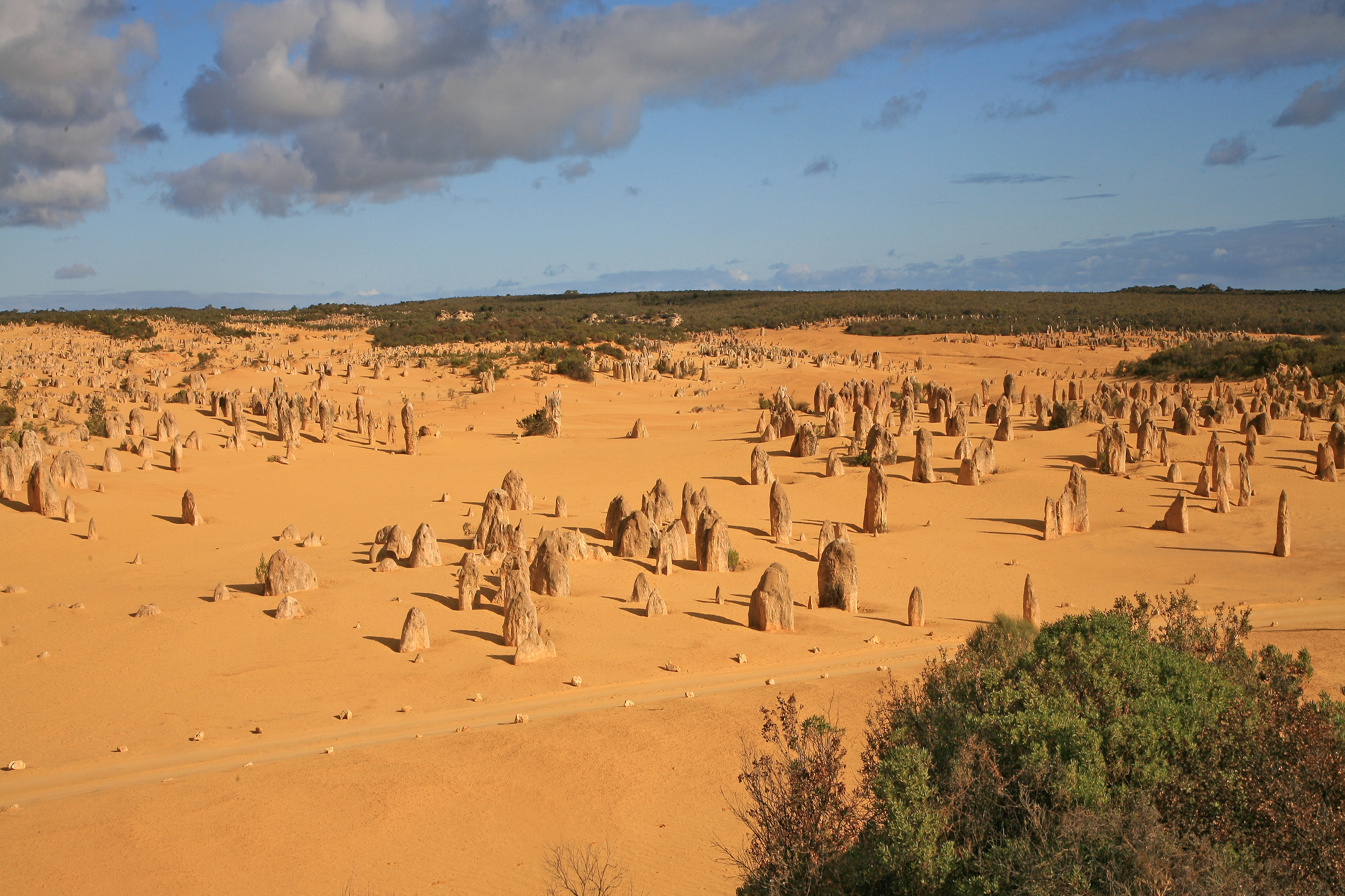
The Pinnacles are one of the strangest and most photogenic landscapes in Australia: thousands of limestone columns, some just a few centimetres tall and others up to 3.5 metres high, rising from a desert of golden sand like a petrified forest or an army of figures planted in the middle of nowhere. They are in Nambung National Park, on Western Australia's Coral Coast, and are one of the classic getaways from Perth.
These formations are purely natural in origin (water, sand, seashells and tens of thousands of years of erosion), but the effect is so surreal it looks otherworldly. Walking among the pinnacles at sunrise or sunset, when the raking light stretches the shadows and the sand turns orange, is an unforgettable experience. And at night, far from the city lights, the starry sky over the desert is spectacular.
This guide explains how to visit the Pinnacles with a practical eye: how to get there from Perth, park entry, the driving loop (Pinnacles Desert Drive), the best times for photos, and what else to see nearby: the lobster town of Cervantes, Lake Thetis with its ancient thrombolites, the Lancelin dunes and the scenic Indian Ocean Drive. It also honours the cultural importance of the site for the Yued people of the Noongar nation, the traditional custodians of this land.
The Pinnacles, inside Nambung National Park, formed over tens of thousands of years from the Tamala Limestone: coastal deposits of seashells and dune sand that, as groundwater rich in calcium carbonate seeped through, cemented into hard columns; the wind then eroded the softer sand and exposed the limestone towers. The area is the traditional land of the Yued (Yuat) people, a group of the Noongar nation recognised as custodians of the park, for whom the site holds deep spiritual value (it is considered a sacred place linked to women) and features in Dreaming stories. There is archaeological evidence of Aboriginal use going back at least 6,000 years. Europeans only "rediscovered" the landscape in the 20th century (although Dutch explorers sighted the coast in the 17th), and in 1994 the area became part of Nambung National Park, now managed in partnership with the Yued Aboriginal corporation. The full story is on our history page.
Read the full history ↓Australia's largest state, covering almost a third of the continent: the ancestral land of the Noongar people and dozens of desert nations, colonised from the Swan River Colony in 1829, transformed by Kalgoorlie gold and today a global iron ore powerhouse. Its capital, Perth, is the most isolated major city on the planet.
Read the history of Western Australia →No exact prices: a scale from $ (budget) to $$$$$ (luxury), with 2-3 options per category.
Origins, formation and what the sources say.
Picture a desert of yellow sand, flat and silent, and then, suddenly, thousands of stone columns sticking out of it: some the size of a finger, others as tall as a person, a few almost four metres high. Some are sharp spikes; others are squat blocks shaped like mushrooms or headstones. At dawn, when the low light stretches the shadows, they look like a petrified army or the ruins of a forgotten city. This is the Pinnacles Desert, inside Nambung National Park, on the Coral Coast of Western Australia.
The amazing thing is that this surreal landscape isn't made by people and it isn't a fantasy. It's pure geology. The Pinnacles formed over tens of thousands of years from what is called the Tamala Limestone, a coastal deposit made of crushed seashells and sand from ancient dunes. As rainwater seeped through the sand, it carried calcium carbonate with it and, with the help of microorganisms, slowly cemented the grains into hard rock. Where that rock held up, the columns remained. The wind did the rest, sweeping away the softer sand around them and exposing the limestone towers.
The most recent dating, based on iron-rich minerals in the formations, suggests that the pinnacles as we see them today emerged around 100,000 years ago, although other estimates speak of tens of thousands of years since the sea retreated and left the shell deposits behind. Whatever the exact figure, it's an extremely slow process that is still going on: the sands keep shifting and, over the centuries, some pinnacles get buried while new ones appear. It's a living landscape, always changing.
Long before the pinnacles became a tourist attraction, this stretch of coast was, and still is, the traditional country of the Yued people (also spelt Yuat), a dialect group of the great Noongar nation, whose lands cover the whole south-west of Western Australia. The Yued are recognised as the Traditional Custodians of Nambung National Park, and their connection to this land goes back thousands of years.
Archaeological evidence confirms how old that connection is. Stone tools and other artefacts found in the Pinnacles area point to Aboriginal use going back at least 6,000 years, with people visiting seasonally to gather resources despite the harsh environment. The Noongar organised their lives around six seasons (not four), moving across country in step with the availability of food, the flowering of plants and the migration of animals. This ecological knowledge was refined over countless generations.
For the Yued, the Pinnacles aren't just a geological feature but a place of deep spiritual meaning. Within Noongar tradition, the site is especially revered as a place associated with women, linked to ceremonies, births and women's cultural practices. In oral tradition, the formations are explained through Dreaming stories (the time of creation). Depending on the version, the pinnacles are petrified trees, ancient anthills transformed by ancestral beings, or the stone remains of young people or warriors. Stories like these were never just tales: they passed on cultural law, the kinship system and the seasonal calendar, and taught people how to read the landscape. So when you visit the Pinnacles, remember that you're walking on a place sacred to First Nations people, and explore it with respect.
The coast off the Pinnacles was among the first parts of Australia that Europeans ever sighted, long before anyone dreamed of colonising the continent. As early as the 17th century, ships of the Dutch East India Company (VOC) sailing to the Spice Islands in Asia rode the westerly winds across the Indian Ocean. If they got their longitude wrong, they ran into the western coast of "New Holland", as they called Australia.
That coast had a bad reputation. It was low and sandy, had no obvious fresh water and was lined with treacherous reefs, and it saw several famous shipwrecks, such as the Batavia (1629) further north. The Dutch mapped stretches of this coastline but judged it inhospitable and commercially worthless, so they never settled there. Some sailors probably sighted this area or even set foot on it, but they left no settlements and no detailed records of the pinnacles.
Interestingly, the name of the base town, Cervantes, doesn't come from Dutch explorers but from a ship: the American whaler Cervantes, which was wrecked off this coast in 1844. So the region's place names carry echoes of whalers, navigators and settlers, layered over a land that had already had Noongar names and owners for thousands of years. For centuries, while the limestone quietly held its columns inland, this coast remained a dangerous place to pass by rather than a destination.
Although the Yued had always known about the pinnacles, and some local settlers and fishers knew they were there, the wider public paid them almost no attention for much of the 19th and 20th centuries. The area was remote, surrounded by dunes that were hard to cross, with no roads or services, and it didn't appear on tourist maps.
The modern "rediscovery" only came in the second half of the 20th century, when access improved and photographs began spreading images of this surreal stone forest. The area was protected and, in 1994, it officially became part of Nambung National Park. The name comes from a Noongar word (associated with a watercourse or with the winding shape of the land). The park protects more than the pinnacles: it also covers dunes, coastal heath, beaches and nearby Lake Thetis with its thrombolites, structures built by microorganisms related to the oldest forms of life on Earth.
Protection brought infrastructure: the Pinnacles Desert Drive (the driving loop among the columns), walking trails and the Pinnacles Desert Discovery Centre, an interpretive centre that explains the geology and, more and more, the site's Aboriginal cultural heritage. In recent decades, WA's Department of Biodiversity, Conservation and Attractions (DBCA) has worked with the Yued Aboriginal corporation, bringing the voice and knowledge of the Traditional Custodians into park management and cultural interpretation.
Today the Pinnacles are among the most recognisable and most photographed landscapes in Western Australia, and one of the most popular trips from Perth. Hundreds of thousands of people visit every year, many on full-day tours that combine the pinnacles with Yanchep's wildlife park (koalas), the white dunes of Lancelin (sandboarding) and a lobster lunch in Cervantes. It's a classic Coral Coast loop along the scenic Indian Ocean Drive.
That success brings conservation challenges. The landscape is fragile: the columns can be damaged if people touch or climb them, and the dune ecosystem is sensitive to trampling and to climate change. That's why the park keeps visitors on the driving loop and marked trails, and asks them to stay within the permitted areas. The night sky is protected too. Far from city lights, the Pinnacles Desert is a superb place to see the stars and the Milky Way, and there are astronomy tours that make the most of that darkness.
But perhaps the most important change in recent decades is the growing recognition of the site's cultural side. The story of the Pinnacles is no longer told only as a geological curiosity. It now includes the voice of the Yued people, their Dreaming stories and respect for a sacred place. At its best, visiting the Pinnacles today is a double experience: marvelling at a quirk of nature tens of thousands of years in the making, while recognising that this land has Traditional Owners whose relationship with it is far older than any European map.