Viajá con Gus
HomeArgentinaPiedra del Águila (Limay Valley)
Piedra del Águila (Limay Valley)
🇦🇷 Argentina · Patagonia

Piedra del Águila (Limay Valley)

Jump to what you need
📌Province
Neuquén. Piedra del Águila is in the south of the province, on National Route 237, in the valley of the Limay river, almost halfway between the city of Neuquén, Bariloche and San Martín de los Andes.
📌Best time
Spring and summer (October to March), with milder weather, long days and the fishing and watersports season on the reservoir. Winters on the steppe are cold and very windy.
📌Suggested days
1 day, or as a stop along the way. One day is enough for the lido, the waterfront, the museum and the viewpoints; anyone fishing or boating can stay longer.
📌Language
Spanish.
📌Currency
Argentine peso (ARS). Bring cash: ATMs and card terminals are limited in the region.
📌Fuel
The town has petrol stations, which matters on a stretch of RN237 with long distances between settlements. Leave with a full tank.
📌Getting there
Along RN237 (the Neuquén–Bariloche axis) and the link towards San Martín de los Andes. The nearest airport is Bariloche (BRC), about 2.5–3 hours away; Neuquén (NQN) is another option, about 3–3.5 hours away.
💱 ARS exchange rate
Loading rate…
🌤️ Weather in Piedra del Águila (Limay Valley)
Loading weather…

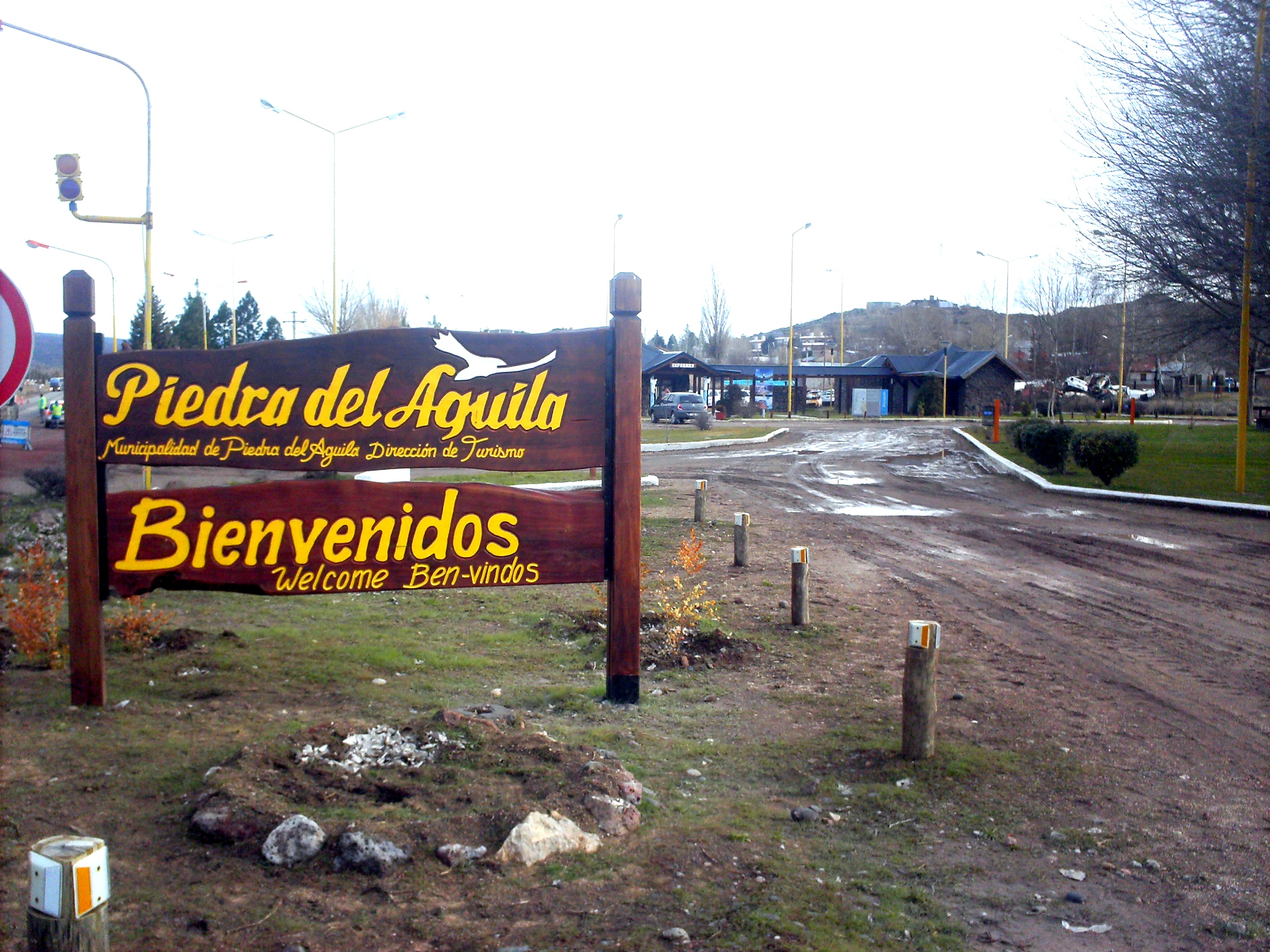
Piedra del Águila is a town on the Neuquén steppe, on National Route 237, in the south of the province, one of the classic stops on the run between Neuquén and Bariloche. Set in the valley of the Limay river, in a region of canyons, bluffs and large reservoirs, it is a place of services and rest in the middle of the arid, windy landscape of the Patagonian steppe.

Its surroundings are shaped by the Limay river and the great artificial lakes formed by the Comahue hydroelectric dams, such as the Piedra del Águila reservoir, one of the largest complexes in the region. These sheets of water, set among rock formations and plateaus, offer sport fishing, watersports, surprising landscapes and a striking contrast between the blue of the water and the ochre tones of the steppe.

For travellers, Piedra del Águila is both a strategic stop on the road — with petrol stations, accommodation and places to eat — and a window onto deep Patagonia: the Limay river, the canyons, the dinosaurs (the region is rich in fossil sites) and the big reservoirs. This guide gathers the practical side of making the most of it: prices, what to see, how to get there and seasonal advice.

📖 History of Piedra del Águila (Limay Valley)

Piedra del Águila grew up as a point on the steppe and an obligatory stop on the road between Neuquén and Bariloche, in the valley of the Limay river. Its development was tied to sheep farming, to trade and, in the 20th century, to the building of the great Comahue hydroelectric dams on the Limay, above all the Piedra del Águila dam, opened in 1993, which transformed the landscape with its enormous reservoir. The region also belongs to the 'Patagonia of the dinosaurs', rich in fossil sites. Today the town combines its role as a service stop on RN237 with a growing tourism tied to the lido, boating, sport fishing and the landscapes of the Limay. The full version is on the history page.

Read the full history ↓

🏛️ Piedra del Águila (Limay Valley) is in Neuquén

The province of volcanoes, lakes and the araucaria: Pehuenche and Mapuche land in northern Patagonia, world capital of the giant dinosaurs, heart of the Vaca Muerta shale and gateway to the Route of the Seven Lakes.

Read the history of Neuquén →

🗺️ What to see

1
Balneario Kumelkayen
The lido on the reservoir, 5 km from town, with a beach, campsite and watersports.
Some 5 km from the centre, Balneario Kumelkayen is the main recreational draw of Piedra del Águila: a beach on the waters of the Pichi Picún Leufú reservoir, formed by the Limay river, with a lit and landscaped waterfront more than 250 metres long. It has full services — toilets with showers, a café, a tourist information office, a campsite with barbecues, parking and boat storage — which make it ideal for a day out in summer. Its waters suit swimming, waterskiing, windsurfing, rowing, kayaking and other watersports, in a beautiful setting of steppe and water.
ℹ️ About 5 km from town; beach, campsite, café and boating. Summer is the best season
2
Piedra del Águila reservoir and dam
One of the great hydroelectric reservoirs on the Limay river, opened in 1993.
The Piedra del Águila hydroelectric complex forms a large reservoir on the Limay river, a sheet of water set among canyons and bluffs that contrasts with the aridity of the steppe. The dam, opened in 1993, is one of the biggest works in the Comahue system, which harnesses the flow of the Limay to generate power. The reservoir allows sport fishing and watersports and offers singular landscapes of water and rock, with natural viewpoints around it.
ℹ️ Access to sections of the reservoir; fishing and boating with a provincial permit
3
Sport fishing on the Middle Limay
One of the finest trout fishing settings in northern Patagonia.
The Middle Limay river and the Piedra del Águila reservoir are considered by anglers worldwide as one of the best fishing environments in northern Patagonia. You catch good-sized rainbow and brown trout, perch and Patagonian silversides, both from the shore and from a boat. Fly fishing and spinning have internationally famous grounds here. You need the provincial sport fishing permit (continental Patagonian), which is valid in Neuquén, Río Negro, Chubut and the national parks.
ℹ️ Provincial permit compulsory; season opens on 1 November. Trout, perch and silverside
4
Monumento al Águila and viewpoints
Sculptures and natural viewpoints looking over the valley and the reservoir.
You discover the town on foot, among natural viewpoints and sculptures that celebrate its identity, such as the Monumento al Águila, the emblem of the place. From the high points you take in the contrast between the blue of the reservoir, the ochre tones of the bluffs and the immensity of the steppe. It is a good walk for photos and for understanding the geographical setting where the river, the dam and the Patagonian plateau meet.
ℹ️ In town and around it; free access. Bring a windproof jacket
5
Archaeological museum and Paseo de las Esculturas
The town's archaeological, historical and artistic heritage.
Piedra del Águila keeps an archaeological museum bringing together objects and records of the settlement of the region, from the early indigenous peoples to the recent history tied to the dam. Added to that is the Paseo de las Esculturas, an open-air route where local art converses with stone and landscape. Together they offer a look at the history and culture of this corner of the steppe, ideal alongside a visit to the lido and the viewpoints.
ℹ️ In town; check opening times and admission (usually free or by donation)
6
Valley and canyons of the Limay river
Landscapes of steppe, bluffs and canyons along the river.
The Limay river crosses the region carving canyons and forming a valley of stark beauty, between multicoloured bluffs and plateaus. It is a typically Patagonian landscape of wide horizons, wind and intense light, taken in from RN237 and from local roads and viewpoints. Beyond the fishing, the valley invites drives, photography and contemplation of the contrast between the water of the reservoirs and the aridity of the steppe.
ℹ️ Visible from RN237 and local roads; drive carefully because of the wind
7
The Patagonia of the dinosaurs
An area rich in fossils, at the heart of Neuquén's dinosaur country.
Southern Neuquén and the Limay basin are part of one of the richest regions in the world for dinosaur fossils. Although the big palaeontology museums are in other Neuquén towns (such as Plaza Huincul, with the Museo Carmen Funes, or Villa El Chocón, with the Museo Ernesto Bachmann and its dinosaur tracks), the area around Piedra del Águila belongs to this 'Patagonia of the dinosaurs', with finds that speak to the prehistoric past of the steppe. It is a good starting point for putting together a palaeontology route across southern Neuquén.
ℹ️ Dinosaur museums in Plaza Huincul and Villa El Chocón (a few hours away); ask at the tourist office
Advertisements
What nobody tells you

💵 Prices

Tickets

TypePrice
Balneario Kumelkayen (access)Free; the campsite and some services may carry a separate charge (source: Municipalidad de Piedra del Águila, verified July 2026)
Sport fishing permit — annual (Neuquén residents)$ 40,000 ARS for the full season; $ 20,000 ARS for the special 10-day permit (source: Caza y Pesca del Neuquén, 2025/26 season, verified July 2026)
Sport fishing permit — non-resident foreignersDaily $ 50,000 ARS; 10 days $ 140,000 ARS; full season $ 280,000 ARS (source: Caza y Pesca del Neuquén, verified July 2026)
Additional trolling permitDaily $ 20,000 ARS; full season $ 80,000 ARS (source: Caza y Pesca del Neuquén, verified July 2026)
Additional permit for preferential zonesDaily $ 10,000 ARS; 10 days $ 20,000 ARS; season $ 40,000 ARS (source: Caza y Pesca del Neuquén, verified July 2026)
Fishing permit exemptionsResidents over 65, retirees and children under 12 do not pay (source: Caza y Pesca del Neuquén, verified July 2026)
Archaeological museum and Paseo de las EsculturasFree or by donation (verified July 2026; check opening times on arrival)
🔄 updated monthlyOfficial / reference values · double-check when buying

Activities and tours

ActivityPriceDurationOperator
Sport fishing on the reservoir and the LimayProvincial permit from $ 20,000 ARS (10 days, Neuquén residents) up to $ 280,000 ARS (full season, foreigners); general season from 1 November to 1 May, with some waters open longer (source: cazaypesca.neuquen.gob.ar, verified July 2026); guides US$ 150–400 a day (range based on licensed local guides)VariableOn your own or with licensed fishing guides (with a provincial permit)
Watersports at Balneario KumelkayenFree access; equipment rental depends on the operator, no official rate published (verified July 2026, ask at the lido)VariableBalneario Kumelkayen / local operators
Camping and a beach day at Kumelkayen$ 5,000–12,000 ARS per tent/night at the campsite (range based on visitor reviews, verified July 2026)A day or several daysThe lido campsite
Touring the landscapes, viewpoints and sculpturesFree (open access) plus fuelHalf a dayOn your own
🔄 updated monthlyOfficial / reference values · double-check when buying
Advertisements

🚌 How to get there and distances

Getting around

ModePriceDurationNotes
Own carFuel; rental US$ 50–90 a day if you pick it up in Bariloche or Neuquén (range based on rental agencies, verified July 2026)VariableThe main way to explore the region and reach the lido; a stopover town on RN237
Local remís / taxi$ 3,000–8,000 ARS per trip in town and to the lido (range based on local remís firms, verified July 2026)VariableUseful for getting from town to Balneario Kumelkayen (5 km) or to the bus terminal
Long-distance buses (stop)Neuquén–Bariloche $ 30,000–75,000 ARS depending on the leg (range based on Vía Bariloche and Albus, verified July 2026)VariableThe Neuquén–Bariloche services and those to San Martín de los Andes usually stop in the area
🔄 updated monthlyOfficial / reference values · double-check when buying

How to get there

RouteAirlines / operatorsAvg. priceDuration
Neuquén → Piedra del Águila (RN237)Long-distance buses (Vía Bariloche, Albus, Andesmar), car$ 30,000–75,000 ARS each way depending on the service (range based on bus companies, verified July 2026)About 3 to 3.5 h (some 250 km)
Bariloche → Piedra del Águila (RN237)Long-distance buses (Vía Bariloche, Albus), car$ 25,000–65,000 ARS each way (range based on bus companies, verified July 2026)About 2.5 to 3 h
San Martín de los Andes → Piedra del Águila (RN40 / RN237)Car, regional buses$ 25,000–60,000 ARS each way (range based on regional buses, verified July 2026)About 2.5 to 3 h
Flight to Bariloche (BRC) or Neuquén (NQN) plus transferAerolíneas Argentinas, Flybondi, JetSmart plus bus or carAir fare US$ 60–190 each way plus the overland transfer (range based on flight search engines, verified July 2026)Flight plus 2.5 to 3.5 h on the road
🔄 updated monthlyOfficial / reference values · double-check when buying

🏨 Where to stay

No exact prices: a scale from $ (budget) to $$$$$ (luxury), with 2-3 options per category.

CategoryPriceRecommended options
Budget (guesthouses and camping)$$$$$US$ 15–35 a night (range based on Booking and local reviews, verified July 2026): guesthouses, small residenciales and the lido campsite, handy for travellers passing through
Mid-range hotels and cabins$$$$$US$ 40–80 a night (range based on Booking, verified July 2026): hotels and cabins along the road and in town, with full services. A good option if you are staying to fish or enjoy the reservoir
Roadside inns and lodgings$$$$$US$ 50–100 a night (range based on Booking, verified July 2026): inns and complexes next to the petrol stations, convenient for a stop on the Neuquén–Bariloche run

🍴 Where to eat

TypePriceOptions / signature dish
Grills and roadside food$$$$$US$ 8–18 per dish (range based on traveller reviews, verified July 2026): grills, canteens and roadside restaurants in town, with meat, milanesas and generous quick dishes
Regional Patagonian cooking$$$$$US$ 12–25 per dish (range based on Tripadvisor, verified July 2026): lamb, trout and regional dishes in local canteens and restaurants. Book in high season
Cafés, bakeries and takeaways$$$$$US$ 4–10 (range based on traveller reviews, verified July 2026): cafés, bakeries and takeaways for a quick restock on the road, with pastries, sandwiches and food to go
Advertisements

📖 History of Piedra del Águila (Limay Valley)

Origins, formation and what the sources say.

A town of the steppe and of the road

Where anglers from all over the world now cast their fly lines over a turquoise reservoir, barely four decades ago there was only a river hemmed in by bluffs and a handful of wind-battered sheep estancias. The dam that flooded that canyon in 1993 did not just generate power for much of the country: it completely transformed the identity of a town that until then was, above all, one more point on the map of the steppe. To understand Piedra del Águila is to understand that break between before and after the water.

Piedra del Águila was born and grew as a point on the vast Neuquén steppe, in the valley of the Limay river, tied from its beginnings to the road and to the traffic of northern Patagonia. Its name evokes the rock formations of the steppe landscape typical of the region, where the bluffs and canyons carved by wind and water dominate the horizon.

After Patagonia was incorporated into the Argentine state in the late 19th century, the region was slowly settled by ranchers and smallholders devoted above all to sheep farming, the traditional economic activity of the Patagonian steppe. The Limay river, which marks the border with Río Negro and crosses the area, was a vital element in this arid landscape, a source of water and a geographical reference.

As the road network linking the city of Neuquén with the mountains and Bariloche took shape — especially the route that would become today's RN237 — Piedra del Águila turned into a place of passage and services. Its position halfway along gradually shaped it as a natural stop for travellers, hauliers and people of the region.

The Limay dams and the landscape of reservoirs

The 20th century brought a deep transformation to the Limay valley: the development of the great Comahue hydroelectric system. Harnessing the flow of the Limay and the Neuquén rivers, the state and the energy companies built a series of large dams to generate electricity and regulate the water, in one of the most important infrastructure works in Patagonia.

The Piedra del Águila dam, one of the biggest in the complex, formed an extensive reservoir on the Limay, an enormous sheet of water set among the canyons and bluffs of the steppe. These works changed the landscape, created new bodies of water and gave rise to activities such as sport fishing, on top of their energy role for the Comahue region and much of the country.

Southern Neuquén and the Limay basin also belong to the so-called 'Patagonia of the dinosaurs', one of the richest fossil areas in the world, where remains of some of the largest dinosaurs known have been found. Although the big palaeontology museums are concentrated in other towns in the province, the area around Piedra del Águila is part of this vast territory of prehistoric past, adding another dimension to its identity as a town of the steppe and of the road.

Indigenous peoples and the Limay river

Long before the arrival of the Argentine state and the dams, the valley of the Limay river and the Neuquén steppe were inhabited for millennia by indigenous peoples. Bands of hunter-gatherers roamed these lands following the guanacos and living off the resources of the river and the lagoons, in a landscape of bluffs, canyons and wind-beaten plateaus.

In more recent times, the region formed part of the extensive area of Mapuche and Tehuelche influence. The Limay river — whose name comes from Mapudungun and is associated with 'clear' or 'transparent water' — was a vital axis: a source of water, a route of movement and a geographical reference in an arid land. Along the valley there are archaeological records of these ancient occupations, part of the heritage now safeguarded by museums such as the one in Piedra del Águila.

The incorporation of Patagonia into the Argentine state in the late 19th century, after the military campaigns, opened a new stage of criollo and European settlement, with ranching estancias laid over this old indigenous territory. The memory of the indigenous peoples remains present in the place names, the regional rock art and the cultural identity of the steppe.

From a place of passage to a destination

For much of the 20th century, Piedra del Águila was above all a place of passage: a service stop on the long road between the city of Neuquén and Bariloche, shaped by ranching, by trade and, from the 1980s, by the building of the great hydroelectric dam opened in 1993. The project drew workers and energised the local economy, leaving as its legacy the enormous reservoir that defines the landscape today.

Over time, that reservoir and the Middle Limay river became a first-rate tourist asset. Balneario Kumelkayen, with its beach, its landscaped waterfront and its services, turned the town into a summer destination for boating and relaxing, while trout fishing drew anglers from all over the world, who rate the Middle Limay as one of the best waters in northern Patagonia.

Today Piedra del Águila combines its historic role as a strategic stop on RN237 with a tourist identity of its own: the lido, watersports, fishing, viewpoints, sculptures and the closeness of the 'Patagonia of the dinosaurs'. The town is working to stop being merely a break in the journey and to establish itself as a destination of the Neuquén steppe, with water, rock and wind in the leading roles.

The hydroelectric project: a workers' town on the steppe

The construction of the Piedra del Águila dam, between the mid-1980s and its opening in 1993, was one of the great engineering works of 20th-century Argentina. The project required mobilising thousands of workers from across the country, who settled in camps and neighbourhoods built specially for the job, transforming overnight the scale of a town that until then counted barely a handful of families living off livestock.

During the construction years, Piedra del Águila lived through a kind of boomtown fever: shops, lodgings and services grew at the pace of demand from a floating population far larger than usual. Engineers, labourers and technicians lived alongside the original inhabitants of the steppe in a town that, for a while, worked almost like an energy frontier city.

When the dam opened and the reservoir reached its maximum level, flooding part of the old Limay canyon, many workers moved on to other projects, but part of that growth stayed for good. The power station is still one of the largest generators in the Comahue system, and the reservoir itself — a direct offspring of that monumental project — is the engine of the town's tourism today, in a paradox that sums up much of recent Patagonian history: out of the sacrifice of one original landscape came another, no less beautiful, that now draws thousands of visitors every summer.

📚 Bibliography

  • Wikipedia (ES) — «Piedra del Águila»: https://es.wikipedia.org/wiki/Piedra_del_%C3%81guila
  • Wikipedia (ES) — «Represa Piedra del Águila»: https://es.wikipedia.org/wiki/Represa_Piedra_del_%C3%81guila
  • Wikipedia (ES) — «Río Limay»: https://es.wikipedia.org/wiki/R%C3%ADo_Limay
  • Neuquén Turismo (oficial) — Piedra del Águila: https://turismo.neuquen.gob.ar/piedra-del-aguila/
  • Municipalidad de Piedra del Águila — Qué hacer: https://piedradelaguila.neuquen.gov.ar/que-hacer/
  • Live Argentina — Balneario Kumelkayen: https://www.liveargentina.com/piedradelaguila/balneariokumelkayen.php
  • Welcome Argentina — Qué hacer en Piedra del Águila: https://www.welcomeargentina.com/piedradelaguila/outings.html
  • Interpatagonia — Turismo en Piedra del Águila: https://www.interpatagonia.com/piedradelaguila/index_i.html
  • Neuquén Turismo (sitio oficial provincial): https://neuquentur.gob.ar/

❓ Frequently asked questions

Where is Piedra del Águila?+
In the south of Neuquén province, on National Route 237, in the valley of the Limay river, almost halfway between the city of Neuquén, Bariloche and San Martín de los Andes. It is a classic stop on that run.
What can you do in the area?+
Enjoy Balneario Kumelkayen (beach, campsite and watersports on the reservoir), fish for trout on the Middle Limay — one of the finest settings in northern Patagonia —, visit the viewpoints, the Monumento al Águila, the archaeological museum and the Paseo de las Esculturas, and take in the canyon and bluff landscapes of the steppe.
How much does the fishing permit cost?+
The Neuquén provincial sport fishing permit for the 2025/26 season (1 November to 31 May) costs province residents $ 40,000 ARS for the full season or $ 20,000 ARS for the special 10-day permit. For non-resident foreigners, the daily permit is $ 50,000 ARS, 10 days $ 140,000 ARS and the full season $ 280,000 ARS. Children under 12, retirees and residents over 65 do not pay. You buy it at cazaypesca.neuquen.gob.ar. Check the prices when you visit.
Why is it considered a strategic stop?+
Because on RN237, in the middle of the steppe, it concentrates petrol stations, accommodation and places to eat, making it a natural point to rest and restock on the long run between Neuquén, Bariloche and San Martín de los Andes.
When is the best time to visit?+
Spring and summer (October to March), with milder weather, long days and the fishing and watersports season on the reservoir. Winters on the steppe are cold and very windy, which is worth bearing in mind for a road trip.
Sources consulted (10)
Still planning?
Explore more destinations in Argentina
See all destinations →
Advertisements
Image credits
Photos from Wikimedia Commons, each under its own licence (CC BY, CC BY-SA or public domain). Open each file to see its author and licence.
Hola piedra