Viajá con Gus
Home › Sierra Leone › Mount Bintumani
Mount Bintumani
🇸🇱 Sierra Leone · The north and the mountains

Mount Bintumani

🪪 What do I need to enter Sierra Leone?Pick your citizenship and we tell you the visa, the days and the paperwork, with the official source.

By leaving your email and citizenship you agree to receive the documents you asked for and weekly travel news. You can unsubscribe whenever you want. How we handle your data.
Jump to what you need
📍Region
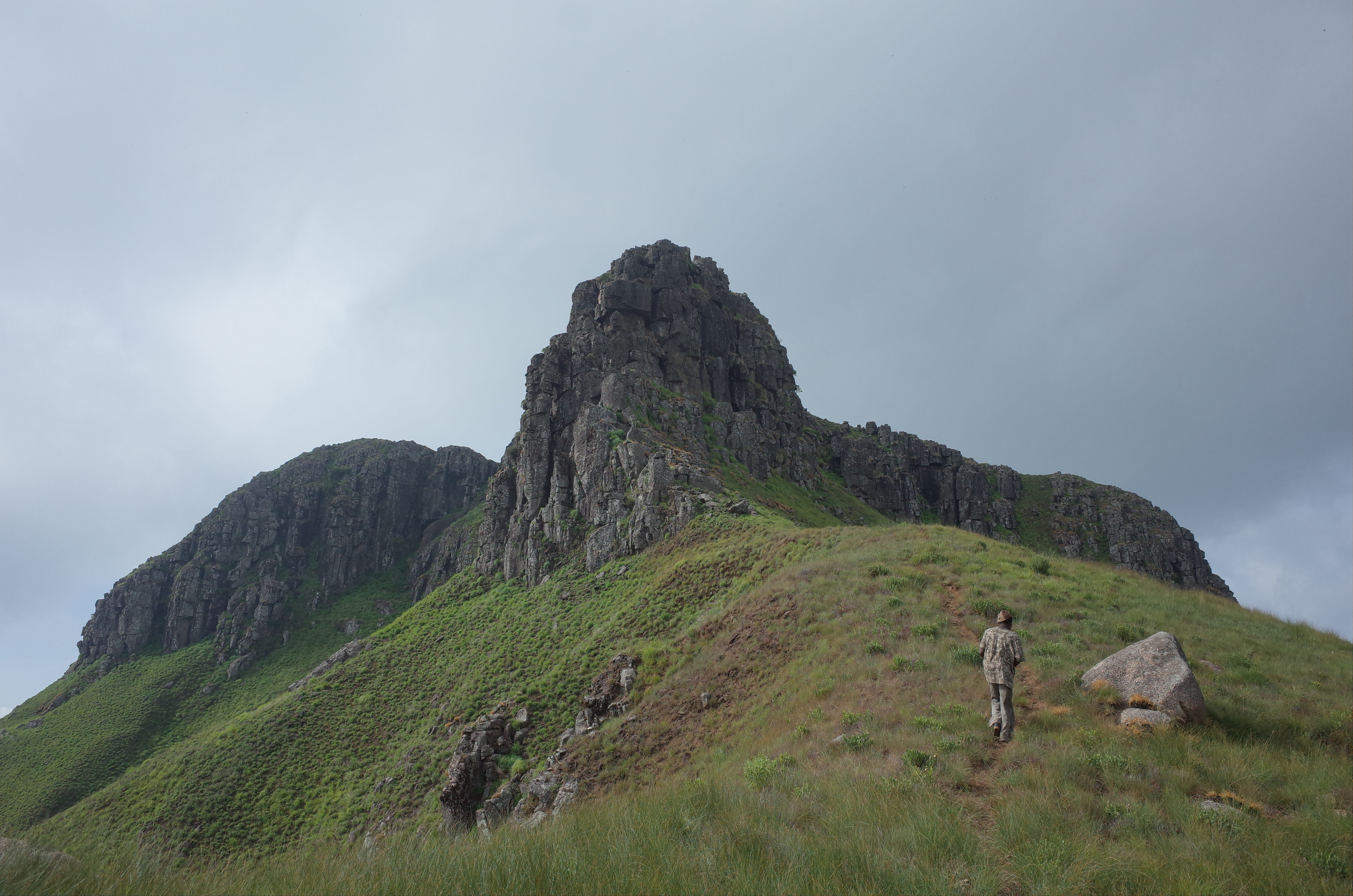
Mount Bintumani (also called Loma Mansa) is, at 1.948 metres, the highest peak in Sierra Leone and the highest in West Africa (as far as Mount Cameroon). It rises in the Loma Mountains, in the north-east of the country, between the districts of Koinadugu and Falaba, inside the Loma Mountains National Park. It is a wild massif of montane forest, high grasslands and rocky outcrops, very remote and rarely visited, whose name evokes a mythical female spirit that, according to tradition, lives on the mountain.
📌Best time to go
The best and practically the only advisable time is the dry season, especially January to April (or December to March), when the rivers have dropped, the trails are firmer and the climb is safer and faster. In the rainy season (May to October) the paths turn into a quagmire, the rivers rise and the trek becomes dangerous and impassable. Even in the dry season it's cold at the summit at night: come prepared for the chill of altitude.
📌Suggested days
The ascent of Bintumani is a multi-day expedition. On the most popular route (from Sinekoro) you need about 2 to 3 days of actual walking, but plan on 4 or 5 days in total once you count the long approach journey and the negotiations with the communities. Other routes (Yifin, in the west) take 4 to 5 days of walking. All in all, from Freetown, it's worth setting aside a week to do Bintumani without rushing.
📌Getting there
Access is long and adventurous. From Freetown you go to Makeni and then to Kabala (the base for the mountain region) by shared taxi. From Kabala you reach the access village —Sinekoro for the most popular route— by motorbike or 4x4, a trip that can take half a day on bad roads, with river crossings. The walk starts from the village. Arranging guides, porters and permits with the communities is essential, and it's worth coordinating with an operator.
📌Getting around
Bintumani is done entirely on foot, with local guides and porters, which are mandatory. It's a non-technical trek (no climbing needed) but physically demanding: hot, humid forest in the lower sections, with slippery trails, then high grasslands and a final rocky stretch to the summit. You camp along the route (in the village, at a high camp). You have to carry everything: food, tent or shelter, warm clothes, water and gear, for the porter team as well.
📌Language and currency
The official language is English and the lingua franca is Krio; in the area people speak Koranko and other northern languages. Communicating with the mountain communities usually requires a guide to translate. The currency is the new leone (SLE), at about 22–24 to the dollar in 2026. There are no ATMs or card payments anywhere in the area: bring all the cash you'll need from Freetown or Makeni for guides, porters, food, permits and the 'community fees' that are usually negotiated.
📌What it is
Highest peak in Sierra Leone and West Africa (1.948 m), in the Loma Mountains; a non-technical but demanding multi-day trek, very remote, through montane forest and high grasslands.
💱 SLE exchange rate
Loading rate…
🌤️ Weather in Mount Bintumani
Loading weather…

Mount Bintumani is the roof of Sierra Leone and of all West Africa: 1.948 metres of montane forest, high grasslands and rock in the Loma Mountains, one of the wildest and most remote corners of the country. Summiting it is one of the great trekking adventures in the region, a multi-day expedition that crosses humid forest, fords rivers, climbs wooded slopes and comes out onto a landscape of mountain grasslands topped by a rocky stretch to the summit.

It isn't a technical climb —no scrambling skills or climbing required— but it is a physically demanding and logistically complex undertaking, in a territory with no infrastructure, where everything depends on local guides and porters and on good relations with the mountain communities, who manage access. The name 'Bintumani' evokes a mythical female spirit who, according to Koranko tradition, lives on the mountain, and the whole region is wrapped in that aura of a sacred, rugged place.

This guide explains how to tackle Bintumani: how to get from Freetown via Makeni and Kabala to the access villages, which routes exist (Sinekoro, Yifin), how to organise guides, porters and permits, when to go (dry season only), what to bring for several days of self-sufficiency and what to expect from the forest, the cold at altitude and the reward at the summit. It's a destination only for adventurous, well-prepared travellers, but one of the most memorable in Sierra Leone.

📖 History of Mount Bintumani

Mount Bintumani (Loma Mansa), at 1.948 m, is the high point of the Loma Mountains, an ancient massif in north-eastern Sierra Leone. Its name refers to a mythical female spirit of Koranko tradition who, it is said, lives on the mountain. The area, sacred and remote, was for a long time little-explored territory; in the 20th century it became a forest reserve for its natural value, and in recent years it was declared Loma Mountains National Park, protecting its montane forest and wildlife (chimpanzees, pygmy hippo, primates, birds). Today it is a little-frequented adventure trekking destination.

Read the full history ↓

🏛️ Mount Bintumani is in the north and the mountains

Temne and Limba country: Makeni, a booming city, Outamba-Kilimi park on the Guinea border, and Mount Bintumani, the roof of West Africa.

Read the history of The north and the mountains →

🗺️ What to see

1
The summit of Bintumani (1.948 m)
The roof of Sierra Leone and West Africa: a summit of grassland and rock with vast views over the Loma Mountains.
Leer más ↓
Reaching the summit of Bintumani, at 1.948 metres, is the goal and the big reward of the expedition: it's the highest point in Sierra Leone and in all West Africa (as far as Mount Cameroon). The final stretch climbs through high grasslands and ends in a rocky scramble —simple but loose and steep— up to the top, where, in good weather, vast views open up over the sea of mountains and forests of the Loma region. The summit is usually reached at dawn, after leaving the high camp in the early hours, to top out with the first light and before the clouds roll in. The feeling of standing on the roof of a whole region, in such a remote and seldom-trodden place, is the emotional heart of the trek. Getting there: after several days of walking from the access village and a high camp. Best time: dry season (January to April). Tips: set off for the summit in the early hours, bring warm layers (it's cold up top), a head torch and water; follow the guide on the final rocky stretch.
2
The montane forest of the Loma Mountains
The ascent crosses a lush mountain forest (Guinean montane forest), rich in plants, birds and wildlife.
Leer más ↓
A good part of the trek runs through the montane forest of the Loma Mountains, a humid, lush forest covering the lower and middle slopes of the massif. It's a valuable and little-disturbed ecosystem, with a great wealth of plants —huge trees, ferns, epiphytes— and wildlife: forest birds, primates, insects and vegetation that changes with altitude. Walking through this forest, amid the hum of life and the humidity, is an immersive experience, though also the hottest and most demanding part of the ascent, with muddy, slippery trails. The transition from the lower forest to the high grasslands, through different vegetation zones, is one of the trek's natural highlights. Getting there: on the lower and middle sections of the ascent. Best time: dry season (less mud). Tips: footwear with good grip, quick-drying clothes, insect repellent; stay well hydrated in the forest section, which is hot and humid.
3
High grasslands and mountain savannah
Higher up, the forest gives way to grasslands and high savannah, an open and unusual landscape rarely found in the region.
Leer más ↓
As you gain height, the montane forest gives way to high grasslands and mountain savannah ('montane grassland'), an open, rolling and unusual landscape that contrasts with the dense growth below and is rare in this part of Africa. These high grasslands, with their grasses and rocky outcrops, give the upper section of Bintumani an almost moorland feel, with cool air and wide views. This is where the high camp is usually set up, the base for the final push to the summit. The change of atmosphere —from the humid heat of the forest to the coolness of the grasslands— is one of the trek's big attractions and marks the home stretch to the top. Getting there: on the upper sections of the ascent, near the high camp. Best time: dry season. Tips: be ready for the temperature change (it gets very cool up top at night); bring warm layers and a good sleeping bag for the high camp.
4
Wildlife of the Loma Mountains
The massif is home to chimpanzees, primates, pygmy hippos in the rivers, dwarf crocodiles and rare birds.
Leer más ↓
The Loma Mountains and their national park protect remarkable, if elusive, wildlife. Western chimpanzees and several primates live in the forests; in the rivers of the area, the very rare pygmy hippo and the dwarf crocodile; and in the skies and the forest, rare birds such as the rufous fishing owl and many species of the Upper Guinea and montane forest. It's one of the areas of greatest natural value in the country. During the trek, seeing large animals is difficult —they're shy and the terrain is dense— but you may hear chimpanzees, spot birds and primates, and feel you're walking through a biodiversity sanctuary. Local guides know the signs of wildlife and enrich the experience. Getting there: all along the trek, in the forest of the massif. Best time: dry season. Tips: silence and patience for wildlife; binoculars for birds; appreciate tracks and sounds too, rather than waiting for big sightings.
5
The access villages and Koranko culture
The trek starts in mountain villages of Koranko culture, where guides, porters and permits are negotiated and you experience local hospitality.
Leer más ↓
The Bintumani expedition starts and is sustained in the access villages —Sinekoro for the most popular route, or Yifin for another route—, mountain communities of Koranko culture that manage access to the sacred mountain. This is where guides and porters are arranged, permits are requested and 'community fees' are agreed, in a negotiation process that is part of the experience (and best approached with patience and respect). Sleeping in the village, getting to know the life of these remote communities, their mountain farming and their relationship with Bintumani —which they associate with a mythical female spirit— is a valuable and human part of the journey. The local hospitality and the bond with the guides and porters often leave memories as strong as the summit itself. Getting there: Sinekoro or Yifin, from Kabala by motorbike or 4x4. Best time: dry season. Tips: bring cash for the fees and negotiate respectfully but firmly; treat guides and porters well (bring food and gear for them too), as they are the key to the trek's success and safety.
6
Kabala, the mountain base
The picturesque town of Kabala, with its hill and relaxed atmosphere, is the logistics base for Bintumani and the mountainous north.
Leer más ↓
Kabala, capital of Koinadugu district, is the gateway to the mountainous northern region and the logistics base for Bintumani. It's a small, pleasant town with a cooler climate thanks to its altitude, surrounded by hills, with a lively market and a relaxed atmosphere. Its hill (Gbawuria Hill) offers a walk with views, and the town is a traditional meeting point of the northern cultures. In Kabala you do your last shopping, arrange transport to the access villages and pick up contacts and information for the trek. It's also a good place to acclimatise and rest before and after the demanding mountain expedition. Getting there: from Makeni by shared taxi (2–3 hours). Best time: pleasant all year within the dry season. Tips: use Kabala to stock up on food, water and cash before heading into the mountains, where there are no services; ask at guesthouses such as the Hill View to organise the trek.
📶I have never landed without internet. I arrive and my phone connects to the strongest network in the country I am visiting: I can say I landed, sort out transport, book tours and keep posting, at a seriously good price. I always use the Maya eSIM — check their plans by clicking the banner.See plans →Maya Mobile eSIM — download, install, go
What nobody tells you

💵 Prices

Tickets

TypePrice
Permisos del Loma Mountain National Park y tarifas comunitariasNo rate published in an official source: neither the National Protected Area Authority (NPAA, the state body that manages Loma Mountain National Park) nor the National Tourist Board publishes prices for permits or community fees. What the National Tourist Board does say is that you must ask the local chief for permission before climbing. The amounts are agreed in the villages (verified 07/08/2026)
Guía obligatorioAgreed in the access village; no official rate published by the NPAA or the National Tourist Board (verified 07/08/2026)
PorteadoresAgreed in the access village; no official rate published (verified 07/08/2026)
🔄 updated monthlyOfficial / reference values · double-check when buying

Activities and tours

Mount Bintumani trek via Sinekoro (return)
Duration2 to 3 days of walking (4–5 days in total)
OperatorLocal guides and communities / operators
Price
Total cost varies by group: guides, porters, transport and community fees; budget several hundred US$ per group (2026)
Trek via the Yifin route (west)
To be agreed; longer route (2026)
Duration4 to 5 days of walking
OperatorLocal guides and communities
Organised package from Freetown (with transport and logistics)
Duration5 to 7 days
OperatorVSL Travel / local operators
Price
From several hundred US$ per person depending on group and days (VSL Travel, 2026; check)
Walk up Kabala hill (acclimatisation)
PriceWith a local guide, approx. US$ 5–15 (2026)
Duration2 to 3 hours
OperatorLocal guides in Kabala
🔄 updated monthlyOfficial / reference values · double-check when buying

🚌 How to get there and distances

Getting around

ModePriceDurationNotes
Shared taxi Makeni ↔ KabalaApprox. SLE 100–300 (US$ 4–13) per seat (2026)2 to 3 hoursThe usual connection to the mountain base; you can also hire the whole car
Motorbike or 4x4 Kabala ↔ access village (Sinekoro)To be agreed, depending on road conditions (2026)Half a day; bad roads with river crossingsDifficult stretch to the village where the walk begins; may be impassable in the rains
On foot (the trek)Cost of guides and porters (see above)2 to 5 days depending on routeThe whole ascent is on foot, with guides and porters; total self-sufficiency (food, water, shelter)
🔄 updated monthlyOfficial / reference values · double-check when buying

How to get there

RouteAirlines / operatorsAvg. priceDuration
Freetown → Makeni → KabalaPoda-podas and shared taxis (+ Sea Coach to Makeni)Freetown–Makeni approx. SLE 150–400 (US$ 7–18); Makeni–Kabala SLE 100–300 (US$ 4–13) (2026)2,5–3,5 h to Makeni + 2–3 h to Kabala
Kabala → Sinekoro (access village, popular route)Local motorbike or 4x4To be agreed; difficult roads (2026)Approx. half a day
Kabala → Yifin (west route)Local transportTo be agreed (2026)Variable; longer route
Organised package from FreetownVSL Travel / operatorsIncluded in the package price (2026)5 to 7 days with transport and logistics included
🔄 updated monthlyOfficial / reference values · double-check when buying

🏨 Where to stay

No exact prices: a scale from $ (budget) to $$$$$ (luxury), with 2-3 options per category.

Camping on the trek (tent / village shelter)
Price$$$$$
Recommended options
Cost included in the trek arrangement; you camp in the access village (the chief's compound) and at a high camp; your own tent or a very basic shelter, no facilities; cold nights up top
Guesthouses in Kabala
Price$$$$$
Recommended options
Approx. US$ 10–35 per night; simple places such as the Kabala Hill View Guesthouse or basic options, a base for organising the trek and resting before/after
Base in Makeni (hotels)
Price$$$$$
Recommended options
US$ 15–90 per night in Makeni; more comfortable hotels to sleep at the start/end of the trip, before heading into the mountains

🍴 Where to eat

Comida propia en el trek
Price$$$$$
Options / signature dish
Cost of your supplies; you have to bring all the food for yourself and the porters from Kabala (rice, tinned food, snacks, water or purification); there's nothing to buy on the mountain
Chop bars y mercado de Kabala
Price$$$$$
Options / signature dish
US$ 2–6 per dish; local Sierra Leonean food in Kabala to eat well and stock up before the trek
Comida en Makeni (antes/después)
Price$$$$$
Options / signature dish
US$ 2–15 per dish in chop bars and town hotels; a good place for a full meal on your return

📖 History of Mount Bintumani

Origins, formation and what the sources say.

The roof of West Africa

Mount Bintumani, also known as Loma Mansa, rises 1,945 metres above sea level and holds a remarkable title: it is the highest mountain in Sierra Leone and the highest peak in all of West Africa until you reach Mount Cameroon, far to the east. It is the summit of the Loma Mountains, an ancient massif in the northeast of the country made up of crystalline rock heavily eroded over geological eras.

The Loma Mountains are a world apart within Sierra Leone: a high, humid and remote territory where altitude creates a patchwork of environments, from humid montane forest on the slopes to grassland and high-altitude savannah on the summits. It is an open, cool landscape that is rare in this part of tropical Africa. That range of ecological zones makes the massif a unique refuge for biodiversity.

Because of its height, its remoteness and its rugged character, Bintumani and the Loma Mountains long remained outside the reach of exploration and dense settlement. They were, and to a large extent still are, a wild territory that is hard to reach, wrapped in the mist of the heights and in the traditions of the communities living on their lower slopes.

Bintumani, the spirit of the mountain

The name 'Bintumani' carries deep cultural meaning. According to the tradition of the Koranko people, who live in the Loma Mountains region, the mountain is home to a mythical female spirit, often described as a woman or a mountain goddess, and the summit takes its name from her. This sacred character runs through the relationship between local communities and the massif.

Its other name, Loma Mansa, means something like 'king of Loma' or 'chief of the Loma Mountains', reinforcing the idea of the summit as a dominant and revered presence. For the Koranko communities on its slopes, the mountain is not just a geographical feature but a place with a spiritual dimension, surrounded by respect, stories and certain taboos.

This cultural background is an essential part of visiting Bintumani. Access to the mountain runs through the villages on its slopes, which manage entry and whose residents work as guides and porters. Heading into the massif means entering a territory its owners consider sacred. Respecting that relationship, and the communities who embody it, matters as much as being physically prepared for the trek.

From forest reserve to national park

Naturalists recognised the extraordinary natural value of the Loma Mountains early on. The massif holds one of the most important mountain ecosystems in Sierra Leone and the wider region, with montane forest and high grassland, and remarkable wildlife: western chimpanzees, several primate species, the very rare pygmy hippopotamus and the dwarf crocodile in its rivers, and uncommon birds such as the rufous fishing owl.

Because of that value, the area was designated in the 20th century as a forest reserve (Loma Mountains Forest Reserve), a protected status aimed at preserving its forests. Over time, as part of Sierra Leone's efforts to expand and modernise its network of protected areas after the civil war, the Loma Mountains were upgraded to Loma Mountains National Park, in recognition of their importance for conserving biodiversity and watersheds.

The park protects not only the country's highest mountain but also a list of threatened species and a high-altitude ecosystem found nowhere else in Sierra Leone. Its remoteness has, paradoxically, been its best protection: difficult access has kept much of the massif relatively intact, though not free from threats such as hunting and farmland expanding at its edges.

A challenge for explorers and trekkers

For decades, Mount Bintumani has drawn a handful of explorers, naturalists and adventurers willing to take on its remoteness and its difficulties. Reaching the summit requires no climbing skills, as it is a non-technical ascent, but it does mean a multi-day expedition through humid forest, river crossings, muddy trails and a final stretch of grassland and rock, camping and being fully self-sufficient. It is one of the great trekking journeys of West Africa.

The logistics are as demanding as the terrain: you have to reach the remote access villages (Sinekoro on the most popular route, or Yifin on another), negotiate guides, porters and permits with the communities, and carry everything you need for several days. The 'community fees' and the negotiations, which sometimes shift, are part of the adventure and call for patience and respect from the visitor.

This rugged, little-visited character is, for many, Bintumani's greatest appeal: the chance to live a genuine expedition, far from the crowds, in a wild and sacred territory, with the reward of standing on the roof of an entire region. It is neither a mass destination nor an easy one, but an experience for prepared and respectful travellers.

Bintumani today: the country's great mountain adventure

Today, Mount Bintumani is Sierra Leone's great mountain adventure and one of the most sought-after trekking experiences in West Africa for travellers looking for something remote and authentic. As the country rebuilds its tourism image after the war and Ebola, and with the push from ecotourism and milestones such as UNESCO's recognition of the Gola and Tiwai forests, Bintumani is shaping up as a star destination for adventure tourism.

It remains, however, a demanding and niche destination: the lack of infrastructure, the difficult access, the reliance on local communities and the narrow dry-season window keep it an experience for the few. Operators such as Visit Sierra Leone organise expeditions, and Kabala is establishing itself as the logistics base for the mountainous north.

Sacred mountain of the Bintumani spirit, roof of West Africa, biodiversity refuge and challenge for trekkers, Mount Bintumani brings together the best of lesser-known Sierra Leone: wild nature, mountain cultures, hospitality and genuine adventure. For anyone willing to make the effort, reaching its 1,945 metres is one of the high points, literal and symbolic, of a journey through this surprising country.

📚 Bibliography

  • Wikipedia (EN) — «Mount Bintumani»: https://en.wikipedia.org/wiki/Mount_Bintumani
  • Wikipedia (EN) — «Loma Mountains»: https://en.wikipedia.org/wiki/Loma_Mountains
  • Visit Sierra Leone (VSL Travel) — A guide to the Loma Mountains (Mount Bintumani): https://www.visitsierraleone.org/a-guide-to-the-loma-mountains-mount-bintumani-the-big-b/
  • Exploring Wild — Climbing Mount Bintumani: Raw Adventure on Sierra Leone's Highest Mountain: https://exploringwild.com/climb-bintumani-sierra-leone/
  • Take Your Backpack — Loma Mountains National Park Guide: https://www.takeyourbackpack.com/backpacking-in-sierra-leone/visit-loma-mountains-national-park/
  • Sierra Leone Tourism — Loma Mountains & Mount Bintumani: https://tourismsierraleone.com/where-to-go/loma-mountains-and-mount-bintumani/
  • Wikipedia (EN) — «Kuranko people»: https://en.wikipedia.org/wiki/Kuranko_people
  • Wikipedia (EN) — «Pygmy hippopotamus»: https://en.wikipedia.org/wiki/Pygmy_hippopotamus
  • Britannica — «Sierra Leone»: https://www.britannica.com/place/Sierra-Leone
  • Wikipedia (EN) — «Koinadugu District»: https://en.wikipedia.org/wiki/Koinadugu_District

❓ Frequently asked questions

How hard is it to climb Bintumani?+
It's a non-technical trek (no climbing or mountaineering gear needed), but physically demanding and logistically complex. It means several days of walking through hot, humid forest with slippery trails, river crossings, and a final stretch of grassland and rock to the summit. You need to be in good shape, accept very basic conditions (camping, total self-sufficiency) and be patient with the logistics. It's not for beginners or anyone looking for comfort, but it is doable for prepared hikers.
When can you climb and when not?+
Practically only in the dry season, especially January to April (or December to March): the rivers drop, the trails are firmer and the climb is safer and faster. In the rainy season (May to October) the paths turn into a quagmire, the rivers rise and the trek becomes dangerous and impassable. Even in the dry season it's cold at the summit at night, so bring warm layers and a good sleeping bag.
Do I need guides and porters? Can I go alone?+
You can't and shouldn't go alone: local guides and porters are mandatory and essential. They know the route, handle relations with the communities that control access and make the trek possible (and safe). You also have to negotiate permits and 'community fees' in the villages. The sensible thing is to organise everything in advance, ideally with an operator such as VSL Travel or with trusted contacts in Kabala, and to treat guides and porters well (bringing food and gear for them too).
How do I get to the start of the trek?+
From Freetown you go to Makeni and then to Kabala by shared taxi (the base for the mountain region). From Kabala you reach the access village —Sinekoro for the most popular route— by motorbike or 4x4, a difficult stretch that can take half a day on bad roads with river crossings. The walk starts from the village. All in all, from Freetown, it's worth setting aside a week to do Bintumani without rushing, counting the approach and negotiations.
What do I need to bring?+
Total self-sufficiency: a tent or light shelter, a good sleeping bag (it's cold up top), warm clothes as well as clothes for heat and humidity, trekking shoes with good grip, a rain jacket, head torch, first-aid kit, insect repellent and malaria prophylaxis, a water filter or purification tablets, and all the food for yourself and the porters (bought in Kabala). Also all the cash you'll need (leones and dollars), as there are no ATMs or shops in the area. Malaria is a real risk in the lower areas.

More places in Sierra Leone

Parque Nacional Outamba-KilimiBahía de River No. 2Santuario de Chimpancés de TacugamaIsla de TiwaiTokehBo
See every place in Sierra Leone →The history of Sierra Leone →
Sources consulted (6)
Still planning?
Explore more destinations in Sierra Leone
See all destinations →
Image credits
Photos from Wikimedia Commons, each under its own licence (CC BY, CC BY-SA or public domain). Open each file to see its author and licence.
Mountain Bintunami