Viajá con Gus
Home › Mongolia › Altai Tavan Bogd
Altai Tavan Bogd
🇲🇳 Mongolia · The west and the Altai

Altai Tavan Bogd

🪪 What do I need to enter Mongolia?Pick your citizenship and we tell you the visa, the days and the paperwork, with the official source.

By leaving your email and citizenship you agree to receive the documents you asked for and weekly travel news. You can unsubscribe whenever you want. How we handle your data.
Jump to what you need
📍Region
Altai Tavan Bogd National Park (Алтай Таван Богд, 'the five saints of the Altai') is the natural gem of Mongolia's far west, in Bayan-Ölgii province, right on the three-way border with Russia and China. It protects a massif of more than 630,000 hectares that holds the country's highest peaks, including Khüiten Peak (4,374 m, the roof of Mongolia). It also has some thirty-four glaciers, led by the great Potanin Glacier at over 20 km long, turquoise alpine lakes, rivers and thousands of ancient petroglyphs recognised by Unesco. It is a high-mountain paradise for demanding trekking, mountaineering and adventure, and very different from the rest of Mongolia.
📌Best time
The realistic window is short: from late June to early September, with July and August as the best months. That is when the passes are open, the rivers can be forded and the mountain weather is at its mildest (even so, it can snow at any moment at these altitudes). Outside that season, snow, extreme cold and impassable tracks make the area very difficult or impossible to reach. Climbs of Khüiten and the other peaks also happen in this short summer. Either way, be ready for changeable weather, cold and wind, even in the middle of August.
📌Suggested days
Altai Tavan Bogd is an expedition, not a day trip. Just getting from Ölgii to the trailheads takes half a day on dirt tracks. The big routes take between 4 and 10 days on foot, on horseback or a mix of both, whether you head to the Potanin Glacier base camp and the lakes or do the classic trek between the massif and the remote lakes. For a lighter visit (a taste of the park, a lake, a glacier and some petroglyphs), allow 2-3 days from Ölgii. Climbing Khüiten is only for experienced mountaineers and takes several days with technical gear.
📌Getting there
Access is from the town of Ölgii, capital of Bayan-Ölgii, which has an airport (ULG) with flights from Ulaanbaatar (MIAT, Hunnu Air, Aero Mongolia; ~2h30-3h). From Ölgii, you need several hours by 4x4 on mountain tracks to reach the trailheads (the Tsagaan Gol area / Potanin base camp, or Khoton Lake). There is no public transport. Important: because the park is on the border, you need a border zone permit, issued in Ölgii (border patrol), as well as the park entry. Without that permit you cannot get in.
📌Getting around
As far as the edge of the park, by 4x4 with a driver. Inside, everything is on foot, on horseback or with pack camels (Bactrian) that carry the gear on longer routes: there are no roads and no infrastructure. You cross rivers, moraines and high mountain valleys, and you camp in a tent or stay in the gers of Kazakh and Tuvan families. This is serious terrain: you need a guide, and for long routes or climbing, a specialist operator, ropes, crampons and experience. There is no mobile signal at all. Bring proper mountain gear: the weather is harsh and changes fast.
📌Language and currency
The region mostly speaks Kazakh (and some Tuvan in certain communities), as well as Mongolian. Apart from the guides, nobody speaks English or Spanish. The currency is the tugrik (MNT, ₮); in mid-2026, 1 US dollar is worth about 3,450 tugriks. Take out ALL your cash in Ölgii before you leave: inside the park and with the families there are no ATMs and cards are not accepted. You will need tugriks for the guide, the horses and camels, park fees, the border permit and family stays. Buying handicrafts and paying Kazakh and Tuvan families directly supports very isolated communities.
💱 MNT exchange rate
Loading rate…
🌤️ Weather in Altai Tavan Bogd
Loading weather…

Where Mongolia ends, in the country's westernmost corner and at the exact point where Mongolia, Russia and China meet, rises its roof: the Altai Tavan Bogd massif, the 'five saints'. These are five snow-capped peaks crowned by Khüiten Peak, Mongolia's highest point at 4,374 metres. It is a high-mountain world unlike anything you expect from this country. Instead of endless steppe or desert, there are glaciers flowing down from the peaks, alpine lakes of an unreal turquoise, glacial rivers and valleys where yaks and camels graze among the moraines. It is Mongolia's great mountain destination and one of the last great wild areas of Central Asia.

Altai Tavan Bogd is serious adventure country. Mountaineers come here to summit Khüiten with crampons and ice axes. Trekkers spend days on the route between the great Potanin Glacier and the park's remote lakes, crossing rivers and sleeping in tents or in the gers of the Kazakh and Tuvan families who spend the summer on these high pastures. It is also a place of huge cultural wealth. Its rocks hold tens of thousands of petroglyphs, some of them thousands of years old, protected by Unesco as World Heritage. They are a record of the peoples who have lived in these mountains since prehistoric times.

This guide tells you how to reach this remote corner (a flight to Ölgii, then hours by 4x4 and days on foot or horseback) and why you need a border permit. It covers when to go in the very short summer window, which routes and climbs the park offers, and what you need in gear, guiding and preparation to move through such demanding, isolated terrain. Getting to Altai Tavan Bogd takes time, effort and logistics, but it rewards you with some of the grandest, most untouched landscapes on the whole continent.

📖 History of Altai Tavan Bogd

Altai Tavan Bogd is above all a place of geology and prehistory rather than political history. Its name, 'the five saints of the Altai', refers to the five great peaks of the massif (Khüiten, Nairamdal, Malchin, Bürged and Ölgii), which local peoples consider sacred. These mountains, in the heart of the Altai range, are one of the oldest inhabited regions of Eurasia. Their valleys hold tens of thousands of petroglyphs, from the Bronze Age about 4,000 years ago through to the era of the ancient Turks (6th-8th centuries). In 2011 Unesco inscribed them as World Heritage under the name 'Petroglyphic Complexes of the Mongolian Altai'. Scythians, Huns, Turks and Mongols passed through or lived in these mountains, and today they are home to Kazakh communities and a small group of Tuvans. In the 20th century, Nairamdal Peak ('friendship') marked the meeting point of the borders of Mongolia, the USSR and China, a powerful symbol in the socialist era. The area was protected as a national park to preserve its glaciers, its mountain wildlife (including the snow leopard) and its rock art heritage. Our history page tells the full story of the Altai's prehistory, its petroglyphs and the peoples who live there.

Read the full history ↓

🏛️ Altai Tavan Bogd is in the west and the Altai

The far west, mostly Kazakh and Muslim: land of the golden eagle hunters, whose age-old tradition is celebrated at the Golden Eagle Festival, and of the snowy peaks and glaciers of Altai Tavan Bogd, where the borders of Mongolia, Russia and China meet.

Read the history of The west and the Altai →

🗺️ What to see

1
The Potanin Glacier and base camp
Mongolia's largest glacier, a tongue of ice over 20 km long at the foot of the five sacred peaks.
Leer más ↓
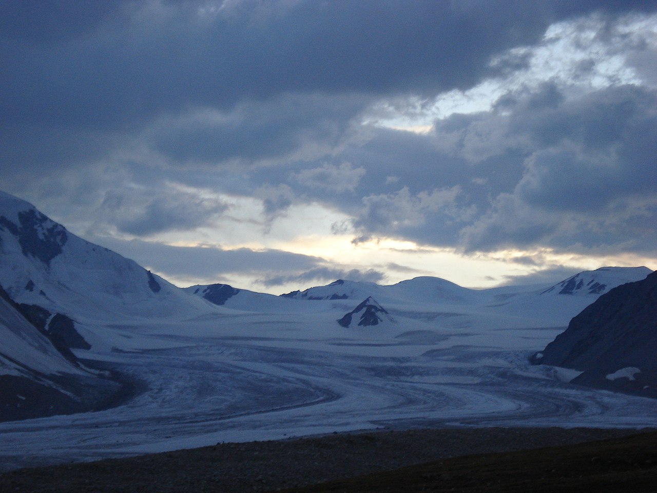
The Potanin Glacier is the park's frozen heart and Mongolia's largest glacier. It is a tongue of ice over 20 kilometres long that flows down from the Tavan Bogd massif, fed by the snows of the five peaks. Reaching its base camp, after a trek of several days from the end of the track, is one of the big goals of trekking in the Altai. The landscape of moraines, ice, glacial rivers and snowy peaks is overwhelmingly grand, more like the high Himalaya or the Andes than most people's idea of Mongolia. From base camp you get a close view of the five 'sacred' peaks and the glacier itself. This is high-mountain terrain: you go on foot or on horseback, with pack camels or horses for the gear, and you camp in a tent. Many routes combine Potanin with a climb to a pass or a lower summit for the best views. Getting there: from the Tsagaan Gol area, after hours by 4x4 from Ölgii and several days of walking. Best time: July and August. Tips: going with a guide and good mountain gear is essential (tent, cold-weather sleeping bag, trekking boots, layers, waterproofs). Altitude sickness is possible, the weather changes fast and it can snow, and you must bring all your cash from Ölgii. This is not a light outing: it takes physical preparation and logistics.
ℹ️ Distance: In the Tavan Bogd massif; several days' walk from the end of the track (Tsagaan Gol) · Best time: July and August (short mountain summer) · Admission: Park entry + border zone permit (both arranged in Ölgii) (verified July 2026) · Duration: 4 to 8 days return, depending on route
2
Khüiten Peak, the roof of Mongolia
The country's highest summit (4,374 m): a technical glacier climb for experienced mountaineers only.
Leer más ↓
At 4,374 metres, Khüiten Peak ('the cold one' in Mongolian) is Mongolia's highest mountain and one of the five summits of Tavan Bogd. Topping it is the great goal of the mountaineers who come to the west of the country, but it is not a hike. It is a technical snow and ice climb on the Potanin Glacier that requires crampons, an ice axe, ropes, roped-travel skills and good acclimatisation to altitude. You climb from a base camp on the glacier in one long, hard day, and you should only attempt it with professional mountain guides and previous high-mountain experience. The reward is huge: from the summit or the col you look out over the five sacred peaks, a sea of glaciers and the lands of three countries at once: Mongolia, Russia and China. Nearby Nairamdal Peak marks the tripoint of the borders. Getting there: base camp on the Potanin Glacier, after the approach from Ölgii. Best time: July and August. Tips: only for mountaineers with glacier experience. Book an expedition with a specialist operator that provides the guide, technical gear and logistics. Acclimatise well, bring gear for serious cold, and keep in mind that bad weather can stop a summit attempt at any moment. Safety comes first: on this remote mountain, a rescue is extremely slow.
ℹ️ Distance: In the Tavan Bogd massif; base camp on the Potanin Glacier · Best time: July and August; short weather window · Admission: Park + border permit + expedition with a mountain operator (verified July 2026) · Duration: 7- to 12-day expedition in total
3
Khoton and Khurgan lakes
Two large turquoise alpine lakes in the south of the park, easier to reach and serenely beautiful.
Leer más ↓
In the southern part of the park, easier to reach than the glacier massif, lie Khoton and Khurgan lakes. These two large alpine lakes, with clean turquoise water, are linked to each other and surrounded by larch forests, meadows and mountains. They are a superb choice if you want the beauty of the Altai without the extreme hardship of the glacier trek. You can camp on their shores, go hiking and horse riding, fish (with a permit) and visit the Kazakh and Tuvan families who spend the summer on these pastures. The setting is beautifully peaceful, with the mountains reflected in the water. The lakes area is also rich in history: nearby there are petroglyphs, burial mounds and other archaeological remains, and it is home to Tuvan communities, a small Turkic people of the region. Getting there: by 4x4 from Ölgii (several hours on dirt tracks), with horse-riding routes possible from there. Best time: summer (late June to early September). Tips: you still need park entry and a border permit. Bring camping gear and warm clothes (nights are cold); the water is cold but clean. Go with a guide, both for finding your way and for contact with the families. It is a good option for a more moderate visit to the park.
ℹ️ Distance: Southern part of the park; several hours by 4x4 from Ölgii · Best time: Summer (late June to early September) · Admission: Park entry + border zone permit (verified July 2026) · Duration: 1 to 3 days
4
The petroglyphs of the Mongolian Altai (Unesco World Heritage)
Tens of thousands of rock carvings up to 4,000 years old, one of the largest collections of rock art in the world.
Leer más ↓
Altai Tavan Bogd and its surroundings hold one of the most important and extensive collections of rock art on the planet. Tens of thousands of petroglyphs were carved into the rock over millennia, and in 2011 Unesco inscribed them as World Heritage under the name 'Petroglyphic Complexes of the Mongolian Altai'. The carvings span a vast stretch of time. They begin in the Bronze Age, about 4,000 years ago, when the region was a grazing valley, continue through the era of the first steppe peoples and reach the ancient Turks of the 6th to 8th centuries. They show animals (deer, ibex, wolves, horses), hunting scenes, carts, rituals and human figures, and form a unique record of the lives of the Altai's nomadic peoples over time. Highlights include the carvings on the sacred mountain of Shiveet Khairkhan and other sites in the park. Seeing them, often out in the open with no infrastructure, is a glimpse into the minds of the people who lived in these mountains long before the Kazakhs or the Mongols. Getting there: scattered across the park and its surroundings, by 4x4 and on foot with a guide. Best time: summer; morning or late-afternoon light shows them best. Tips: go with a guide who knows where they are and what they mean (they are not signposted). Never touch, wet, trace or mark the carvings (they are fragile and irreplaceable). Do not climb on the burial mounds or move stones, and treat these places with the respect that 4,000 years of history deserve.
ℹ️ Distance: Scattered across the park and Bayan-Ölgii (Shiveet Khairkhan and others) · Best time: Summer; low-angled morning or late-afternoon light · Admission: Included with park entry; free access at some sites (verified July 2026) · Duration: Part of the routes through the park
5
The classic trek between glaciers and lakes
The park's great traverse: days on foot or horseback crossing valleys, rivers and passes between the massif and the lakes.
Leer más ↓
For adventurous travellers, the best way to experience Altai Tavan Bogd is the great traverse. This multi-day trek links the glacier area and the Potanin base camp with the southern lakes, crossing valleys, rivers, mountain passes and high pastures. It is one of the most spectacular trekking routes in Central Asia, combining glaciers, snowy peaks, turquoise lakes, forests, petroglyphs and encounters with the Kazakh and Tuvan families who spend the summer in the mountains. You do it on foot or on horseback, with camels or horses carrying the gear, and you sleep in a tent or in gers. Depending on the itinerary and pace (on foot, on horseback or mixed), the full traverse between base camp and the remote lakes usually takes 5 to 10 days. It is demanding because of the altitude, the glacial river crossings, the weather and the isolation, but the scenery is hard to match. Getting there: organised from Ölgii with an operator. Best time: July and August. Tips: a guide and good gear are essential (tent, sleeping bag for intense cold, trekking boots, poles, layers, waterproofs, first-aid kit). Get fit beforehand, and remember the weather can bring snow in summer. Bring all your cash and supplies from Ölgii, and choose a reliable operator, because in an emergency help is very far away. Self-sufficiency and respect for the mountains are key.
ℹ️ Distance: Traverse through the interior of the park, between the Potanin Glacier and the southern lakes · Best time: July and August (short mountain summer) · Admission: Park + border permit + guide/operator; all arranged from Ölgii (verified July 2026) · Duration: 5 to 10 days
6
Kazakh and Tuvan families of the high pastures
The human encounter: sharing the hospitality of the nomadic families who spend the summer in these mountains.
Leer más ↓
In the valleys and high pastures of Altai Tavan Bogd, Kazakh and Tuvan nomadic families spend the summer. They come up with their herds of yaks, sheep, goats, horses and camels to make the most of the mountain grazing. Meeting them is one of the most rewarding human experiences of the trip. The families welcome travellers with their famous hospitality: milk tea, dairy products, bread and sometimes a plate of meat. Spending time in their ger gives you a first-hand look at life in one of the most isolated and beautiful corners of Asia. Many of these families also provide the pack horses and camels for the treks, and some offer accommodation in their gers. Kazakhs are the majority, but a small group of Tuvans also lives in the area. They are a distinct Turkic people with their own language and traditions, related to the people of neighbouring Siberian Tuva. Getting there: along the routes through the park. Best time: summer, when the families are on the high pastures. Tips: behave as a respectful guest (accept things with your right hand, don't step on the ger's threshold) and ask before taking photos. Pay fairly for horses, accommodation and food, and buy handicrafts directly (it is vital support for very isolated communities). Don't hand out money or sweets to children, and if you want to say thank you, bring useful gifts after checking with your guide.
ℹ️ Distance: In the park's valleys and high pastures · Best time: Summer (when the families move up to the mountain pastures) · Admission: You pay for accommodation, food and pack animals; handicrafts extra; cash (verified July 2026) · Duration: Encounters along the trek
📶I have never landed without internet. I arrive and my phone connects to the strongest network in the country I am visiting: I can say I landed, sort out transport, book tours and keep posting, at a seriously good price. I always use the Maya eSIM — check their plans by clicking the banner.See plans →Maya Mobile eSIM — skip roaming fees, unlimited data
What nobody tells you

💵 Prices

Tickets

TypePrice
Entrada al Parque Nacional del Altái Tavan BogdApprox. ₮10,000-30,000 per person (US$3-9), 2025; paid in Ölgii or at the entrance (verified July 2026)
Permiso de zona fronteriza (obligatorio)Arranged at the Ölgii Border Patrol; low fee but essential, bring your passport (verified July 2026)
Caballos y camellos de carga (por día)To be agreed with the families; paid in cash, 2025 (verified July 2026)
🔄 updated monthlyOfficial / reference values · double-check when buying

Activities and tours

ActivityPriceDurationOperator
Potanin Glacier ↔ lakes traverse trekSeveral hundred US$ pp depending on length and group, 20255 to 10 daysÖlgii trekking operators (check)
Khüiten Peak climb (technical mountaineering)Expedition from several hundred to over US$1,000 pp, 20257 to 12 daysSpecialist mountain operators (check)
Route to Khoton and Khurgan lakes with horse ridingTo be agreed with guide and driver, 20252 to 4 daysÖlgii agencies (check)
Guided petroglyph visitIncluded in the tour, 2025Part of the routesLocal guides (check)
Horse riding and stay with nomadic familiesTo be agreed; horses and accommodation paid to the families, 2025VariableKazakh and Tuvan families (check)
🔄 updated monthlyOfficial / reference values · double-check when buying

🚌 How to get there and distances

Getting around

4x4 with driver (to the edge of the park)
Included in the tour package, 2025
DurationSeveral hours from Ölgii
Notes
There is no public transport. The roads are mountain tracks. The 4x4 only goes as far as the trailheads (Tsagaan Gol or the lakes); from there, on foot or on horseback
Pack horse and camel
PriceTo be agreed with the families, per day, 2025
DurationVariable
Notes
Inside the park, for getting around and carrying gear on treks. Kazakh and Tuvan families provide the animals. Serious terrain: river crossings, moraines, high mountains
On foot (trekking)
Free
DurationDays
Notes
The way to explore the interior of the park. Requires good fitness, mountain gear and a guide. No signal or infrastructure; the weather changes fast and it can snow in summer
🔄 updated monthlyOfficial / reference values · double-check when buying

How to get there

RouteAirlines / operatorsAvg. priceDuration
Ulaanbaatar → Ölgii (flight)MIAT Mongolian Airlines, Hunnu Air, Aero MongoliaApprox. US$180-300 one way (₮620.000-1.000.000); higher in peak season, 2025~2h30-3h flight
Ölgii → park entrance (4x4)Tours and local drivers (no public transport)Included in the tour package, 2025Half a day on mountain tracks
Get a border permit in Ölgii (Border Patrol)Border authorities; the agency handles itSmall fee, paid in Ölgii; passport essential, 2025Done before setting off for the park
Park entrance → routes (horse/on foot)Families and operatorsHorses and camels by arrangement, 2025Days of trekking
🔄 updated monthlyOfficial / reference values · double-check when buying

🏨 Where to stay

No exact prices: a scale from $ (budget) to $$$$$ (luxury), with 2-3 options per category.

Tent camping (trekking and mountains)
Price$$$$$
Recommended options
Your own gear or the operator's; price included in the package, 2025; on treks you camp in tents in the high mountains, beside glaciers and lakes. It's the usual way to spend the night inside the park; nights are bitterly cold, so you need a good sleeping bag
Ger stay with nomadic families
Price$$$$$
Recommended options
₮50.000-120.000 per person/night with meals (US$15-35), 2025; sleep in the ger of a Kazakh or Tuvan family on the high pastures, very authentic, with home cooking. It depends on where the families are camped
Hotels and guesthouses in Ölgii (base)
Price$$$$$
Recommended options
₮90.000-250.000 per room/night (US$26-72), 2025; accommodation in the town of Ölgii before and after the expedition, where you sort out logistics, permits and cash

🍴 Where to eat

Comida de expedición / familias
Price$$$$$
Options / signature dish
Included in the package or the stay, 2025. In the mountains you eat what the expedition provides (supplies from Ölgii) or what the families offer: milk tea, dairy, bread, meat stews. Basic food suited to the isolation; bring your own snacks and energy bars
Cocina kazaja y tuvana tradicional
Price$$$$$
Options / signature dish
With the families, 2025. Beshbarmak (meat with noodles), manti (steamed dumplings), dairy, kumis. The hospitality of the high-pasture families is an experience in itself
Restaurantes y cafés de Ölgii
Price$$$$$
Options / signature dish
₮10.000-30.000 per dish (US$3-9), 2025. In town there are eateries serving Kazakh, Mongolian and Central Asian food, to recharge and enjoy a good meal before or after the mountains

📖 History of Altai Tavan Bogd

Origins, formation and what the sources say.

The five saints: the roof of Mongolia

In the far western corner of Mongolia, at the exact point where the borders of Mongolia, Russia and China meet, rises the roof of the country: the Altai Tavan Bogd massif, whose name means 'the five saints of the Altai'. These are five great summits (Khüiten, Nairamdal, Malchin, Bürged and Ölgii) that rule over a high-mountain world radically different from the rest of Mongolia. The highest, Khüiten Peak ('the cold one'), reaches 4,374 metres and is the highest point in the whole country. Around it, a massif with more than 630,000 protected hectares holds some thirty-four glaciers (the largest, the Potanin, is more than 20 kilometres long), alpine lakes, glacial rivers and valleys whose grandeur surprises anyone who links Mongolia only with the steppe or the desert.

These mountains are part of the great Altai range, a chain that stretches across Mongolia, Russia, Kazakhstan and China and that has been, for thousands of years, a crossroads of peoples, climates and ecosystems in the heart of Eurasia. The Altai is one of the most biologically rich regions of Central Asia: its glaciers feed the rivers that bring life to the lands below, and on its slopes iconic species survive, such as the argali (the largest wild sheep in the world), the ibex and the elusive, endangered snow leopard, one of the hardest big cats to spot on the planet.

For the peoples who live in these mountains, the five summits are sacred, as their name suggests. The Altai range has been revered for centuries by Kazakhs, Mongols, Tuvans and, before them, by the nomadic peoples of antiquity. In a country where nature and the spiritual are deeply intertwined, Tavan Bogd is not just a geographical feature but a place full of meaning, an altar of stone and ice at the western edge of Mongolia.

A land inhabited since the Stone Age

Although today it may seem a remote and almost inaccessible corner, Altai Tavan Bogd has been home to human life since very ancient times. Archaeologists have documented a human presence in these mountains since the Palaeolithic, and over the millennia its valleys served as a corridor and a home for countless nomadic peoples. During the Bronze Age, some 4,000 years ago, communities of herders and hunters lived in these high valleys, and the region's most astonishing remains date from that period and the ones that followed: its petroglyphs.

The Mongolian Altai holds one of the world's greatest treasures of rock art. Over thousands of years, tens of thousands of images were carved into its rocks: deer, ibex, wolves, horses, hunting scenes, animal-drawn carts, human figures, rituals. The carvings cover a huge span of time, from the Bronze Age to the era of the ancient Turks, between the 6th and 8th centuries AD. Together they form a unique visual record of how the life, economy and beliefs of the nomadic peoples of the steppe and the mountains changed over thousands of years. In recognition of this outstanding value, UNESCO added the 'Petroglyphic Complexes of the Mongolian Altai' to the World Heritage List in 2011.

Alongside the petroglyphs, the Altai landscape is dotted with other traces of these peoples: burial mounds (the kurgans of the steppe cultures, some of which, across the wider Altai, have preserved mummies and objects in the ice), 'deer stones' with ritual carvings, and the stone statues of Turkic warriors that marked graves, with carved faces and a cup in hand. Scythians, Huns, ancient Turks, Uyghurs and Mongols all passed through or lived in these mountains. According to many scholars, the Altai was one of the cradles of the Turkic peoples who would later spread across half of Asia. Walking among its ancient carvings today means touching the oldest memory of nomadic humanity.

Kazakhs, Tuvans and a mountain of 'friendship'

The peoples living around Altai Tavan Bogd today are mainly Kazakhs, the majority in Bayan-Ölgii province. They are a Turkic, Muslim people who came to these mountains mostly between the 19th and 20th centuries, fleeing pressure from the Russian, Soviet and Chinese empires, and who brought with them their language, their faith and their famous tradition of hunting with golden eagles. But they are not the only ones: a small group of Tuvans also lives in the park's valleys, especially around the lakes. They are another Turkic people, distinct from the Kazakhs and related to those of the neighbouring Russian republic of Tuva, with their own language and customs. Every summer, families from both peoples take their herds of yaks, sheep and horses up to the high mountain pastures, keeping alive a nomadic way of life thousands of years old.

In the 20th century, the geography of Tavan Bogd took on a special symbolic weight because of its border position. Nairamdal Peak, whose name means 'friendship', roughly marks the point where the borders of three states met: the Mongolian People's Republic, the Soviet Union and communist China. In the middle of the Cold War, and within the alliance between Mongolia and the USSR, this 'friendship mountain' on the triple border carried a strong political and symbolic charge. Even today, its border status is the reason why visiting the park requires a special border-zone permit, which is arranged in Ölgii.

This mix of peoples, borders and cultures makes Altai Tavan Bogd a place as rich in human terms as it is in nature. Travellers who explore its valleys don't just cross glaciers and lakes: they share tea in a Kazakh family's ger, see petroglyphs left by peoples who vanished thousands of years ago, and walk through a land where the borders drawn by modern states sit on top of ancient nomadic routes that never knew those lines.

From forgotten frontier to national park and adventure destination

For much of the 20th century, while Mongolia was a socialist state, the far west of the country remained a militarised border region that was hard to reach and barely visited except by its nomadic inhabitants and the odd mountaineer. The fall of the communist regime in the early 1990s and the opening up of Mongolia gradually changed that. Aware of the extraordinary value of its glaciers, wildlife and archaeological heritage, the country created Altai Tavan Bogd National Park to protect this unique massif, one of Mongolia's great protected natural areas.

In recent decades, Tavan Bogd has become one of the great adventure destinations of Central Asia: mountaineers from all over the world come to try to summit Khüiten, the roof of Mongolia, on a technical climb over the Potanin Glacier; trekkers spend days on the routes between glaciers and lakes; and travellers looking for wild nature and nomadic culture explore its valleys on foot and on horseback. All this comes with demanding logistics (flights to Ölgii, border permits, expeditions with guides, horses and pack camels) that keep the area largely away from mass tourism and preserve its remote character.

The park's future brings the usual challenges of high mountains in a time of change. The Altai glaciers, like those all over the world, are shrinking as the climate warms, which threatens the landscape in the long run and, more seriously, the water supply of the lands below. Protecting the wildlife, especially the snow leopard, and the fragile petroglyph heritage requires constant watchfulness. And the balance between opening the park to visitors and protecting both its nature and the way of life of Kazakh and Tuvan families is a delicate one. But for now, Altai Tavan Bogd remains what it has been for thousands of years: a world of sacred peaks, ice and nomadic peoples at the western edge of Mongolia, one of the last great wild landscapes of a continent that is changing at full speed.

📚 Bibliography

  • Altai Tavan Bogd National Park — Wikipedia (EN): https://en.wikipedia.org/wiki/Altai_Tavan_Bogd_National_Park
  • Khüiten Peak — Wikipedia (EN): https://en.wikipedia.org/wiki/Kh%C3%BCiten_Peak
  • Altai Mountains — Wikipedia (EN): https://en.wikipedia.org/wiki/Altai_Mountains
  • Petroglyphic Complexes of the Mongolian Altai — UNESCO: https://whc.unesco.org/en/list/1382/
  • Potanin Glacier — Wikipedia (EN): https://en.wikipedia.org/wiki/Potanin_Glacier
  • Snow leopard — Wikipedia (EN): https://en.wikipedia.org/wiki/Snow_leopard
  • Tuvans — Wikipedia (EN): https://en.wikipedia.org/wiki/Tuvans
  • Kazakhs in Mongolia — Wikipedia (EN): https://en.wikipedia.org/wiki/Kazakhs_in_Mongolia
  • ViewMongolia — Altai Tavan Bogd Mountain National Park: https://www.viewmongolia.com/altai-tavan-bogd-mountain-national-park-mongolia.html
  • Eternal Landscapes — Mongolia's Altai Tavan Bogd National Park: https://eternal-landscapes.co.uk/mongolias-altai-tavan-bogd-national-park/

❓ Frequently asked questions

Do I need a special permit to enter the park?+
Yes. Because it sits on the triple border with Russia and China, Altai Tavan Bogd lies in a border zone, and to get in you need a border permit, issued in Ölgii (at the Border Patrol), as well as the national park entry. Without that permit you can't enter. Usually the agency or operator arranges it for you; you'll need your passport. Sort all of this out in Ölgii before heading into the mountains.
How do I get to Altai Tavan Bogd?+
From the town of Ölgii, capital of Bayan-Ölgii, which has an airport with flights from Ulaanbaatar (~2h30-3h). From Ölgii it's several hours on mountain tracks by 4x4 to the trailheads (the Potanin Glacier area or the southern lakes). There is no public transport. From the edge of the park onwards, everything is on foot or on horseback. It's an expedition: plan it with an operator who handles transport, permits, guide and pack animals.
When can I visit?+
The window is short: from late June to early September, with July and August as the best months, when the passes are open and the rivers can be forded. Even so, at these altitudes it can snow at any time and the weather is harsh and changeable. Outside that summer, snow and extreme cold make the area very difficult or inaccessible. Be ready for cold weather, wind and sudden changes even in the middle of August.
Do I need mountain experience?+
It depends on what you want to do. To get a taste of the park, see Khoton and Khurgan lakes and some petroglyphs, being in good shape and going with a guide is enough. For the big treks to the Potanin Glacier (5-10 days on foot or on horseback) you need good fitness, mountain gear and tolerance for isolation and the weather. And climbing Khüiten Peak (4.374 m) is technical glacier mountaineering, only for people with previous high-altitude experience, with crampons, ropes and a professional guide.
How many days do I need?+
For a lighter visit (lakes, a glacier from a distance, petroglyphs) allow 2-3 days from Ölgii. For the classic trek between the glacier and the lakes, 5 to 10 days. And to summit Khüiten, an expedition of 7 to 12 days in total. On top of that, add the flight and the days in Ölgii for logistics and permits. This isn't a place to rush: getting here and moving around the terrain takes time.
Do I need to bring cash? Are there ATMs?+
Withdraw ALL your cash in Ölgii before setting off: inside the park and with the families there are no ATMs and cards aren't accepted. You'll need tugriks for the guide, the pack horses and camels, park fees, the border permit, family stays and handicrafts. That money directly supports very isolated Kazakh and Tuvan communities. The currency is the tugrik: in mid-2026, about 3.450 to the dollar.

More places in Mongolia

AmarbayasgalantBayan-ÖlgiiBayanzagDalanzadgadDesierto del GobiKarakórum
See every place in Mongolia →The history of Mongolia →
Sources consulted (9)
Still planning?
Explore more destinations in Mongolia
See all destinations →
Image credits
Photos from Wikimedia Commons, each under its own licence (CC BY, CC BY-SA or public domain). Open each file to see its author and licence.
Altai Tavan Bogd - Potanin glacier - panoramio