Viajá con Gus
Home › Mauritania › Zouérat
Zouérat
🇲🇷 Mauritania · The iron train and the mining north

Zouérat

🪪 What do I need to enter Mauritania?Pick your citizenship and we tell you the visa, the days and the paperwork, with the official source.

By leaving your email and citizenship you agree to receive the documents you asked for and weekly travel news. You can unsubscribe whenever you want. How we handle your data.
Jump to what you need
📌Country
Zouérat is the main city in the far north of Mauritania and the capital of the Tiris Zemmour region, with around 40,000-60,000 inhabitants. It is a mining town built by and for iron extraction: here, next to the Kediet Ijill massif (the highest point in the country), lie the huge open-pit mines of the state company SNIM, whose ore keeps the Mauritanian economy going. Zouérat is also the starting point of the legendary iron train, which runs 704 km down to the port of Nouadhibou.
📌Best time to go
Zouérat sits in the deep Sahara, with an extreme desert climate: scorching summers (well above 40 °C) and winters with mild days and very cold nights. The best time to visit is winter (November to March). Be ready for heat, wind and dust storms. Most travellers only come here if they are riding the full length of the iron train or exploring the country's remote mining north.
📌Suggested days
Zouérat is not a conventional tourist destination and is usually seen in a few hours or as the start or end point of the iron train. Half a day or a day is enough to take in the feel of the mining town, the SNIM facilities (from outside), the Kediet Ijill massif and the train's starting point. It is mainly a stopover for adventurers who want the full railway experience or who are heading into the remote Tiris Zemmour region.
📌Getting there
Zouérat has a small airport (OUZ) with domestic flights to Nouakchott. Overland, it is connected by road to Atar and the Adrar (to the south) and to Nouadhibou via Choum. The most epic way to arrive or leave is aboard the iron train, which starts here: from Zouérat the ore-laden convoy heads down to the Atlantic. The area is remote and desert, so it is best to travel with organised transport and, for the desert, with a guide and a 4x4.
📌Getting around
Taxis are used within the city; Zouérat is a sprawling town with a mining-camp layout, made up of SNIM workers' neighbourhoods, industrial facilities and basic services. For any trip into the surroundings (the Kediet Ijill massif, the mines, the Tiris Zemmour desert) you need a 4x4 with a driver-guide. There is no real tourist infrastructure: the city revolves around mining.
📌Language and currency
Hassaniya (the local Arabic) is spoken; some French helps with guides and in offices. The currency is the ouguiya (MRU), at around 40 to the dollar in 2025-2026. Bring cash, as banking services are limited. Since this is a SNIM company town, there is some commercial activity and workers from different parts of the country. Come with everything you need, as it is an isolated outpost in the middle of the desert.
💱 MRU exchange rate
Loading rate…
🌤️ Weather in Zouérat
Loading weather…

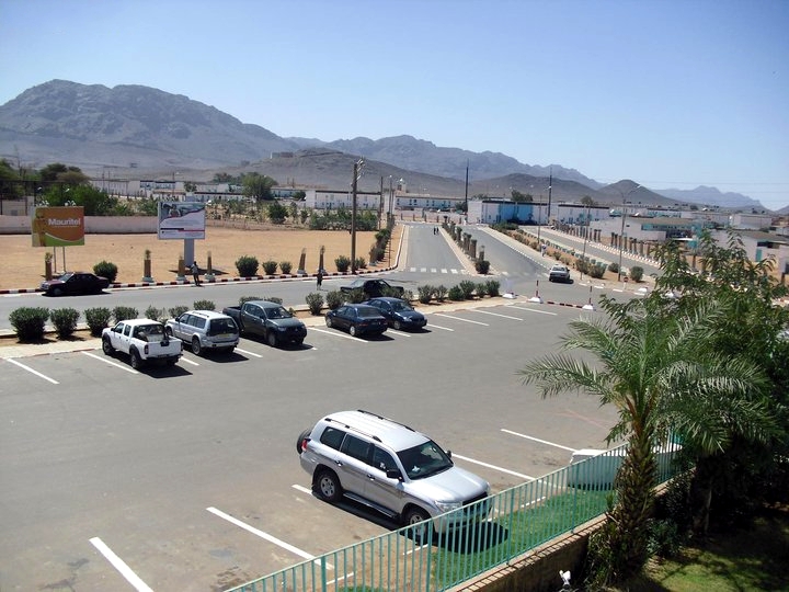
Zouérat is the end of the Mauritanian world to the north: a mining town planted in the middle of the Sahara, more than 700 km from the sea, where the desert turns into a mountain of iron. It is not a destination for postcards or monuments, but a rough, industrial outpost, born from the country's greatest source of wealth —iron ore— and dominated by the state company SNIM, which mines the haematite here that supports much of the national economy.

Its identity rests on two things: it is the starting point of the legendary iron train, which leaves Zouérat loaded with ore and travels 704 km across the desert to the port of Nouadhibou, and it stands at the foot of the Kediet Ijill massif, the highest point in Mauritania, a dark mass packed with iron that was the origin of it all. In a way, Zouérat is the industrial heart of the country, the place where the wealth that rides the longest train in the world comes from.

This guide tells you what to expect from Zouérat: the feel of a Saharan mining town, its role on the iron train route, the imposing Kediet Ijill and the context of the remote Tiris Zemmour region. It is a stopover for adventure travellers who want the full railway experience or who want a glimpse of Mauritania's deep north, one of the most isolated and least visited corners of the country.

📖 History of Zouérat

Zouérat was born in the mid-20th century from a mountain of iron. The presence of ore in the Kediet Ijill massif had been known for a long time, but it was in 1952 that the MIFERMA company was set up to mine these deposits, among the largest in Africa, on an industrial scale. Extraction began around 1960, coinciding with the country's independence, and Zouérat grew up around the mines as a company town. After mining was nationalised in 1974-1975, it passed to the state-owned SNIM, which turned it into Mauritania's great mining centre. The city grew with the iron and with the train that carries it to the sea. Its story is told on our history page.

Read the full history ↓

🏛️ Zouérat is in the iron ore train and the mining north

The iron that keeps the country going comes from the mountains of Zouérat and travels to the sea on the longest and heaviest train in the world, crossing 700 kilometres of Sahara.

Read the history of The iron ore train and the mining north →

🗺️ What to see

1
The Kediet Ijill massif
Mauritania's highest mountain, a dark mass laden with iron that gave rise to the city and to the country's mining industry.
Leer más ↓
Next to Zouérat rises Kediet Ijill (or Kediet ej Jill), the highest point in Mauritania, at around 915 metres. It is no ordinary mountain: its dark colour gives away its make-up, as it is largely formed of iron (haematite and magnetite), in such a high concentration that it is said to throw off compasses nearby. This mass in the middle of the desert was the origin of everything: this is where the great deposit was discovered that gave birth to Mauritanian mining, to the town of Zouérat and to the iron train. The massif dominates the landscape and has undeniable visual power, outlined against the Saharan sky. Mining —open-pit, at several sites around it— has been reshaping the mountain over the decades. For the traveller, seeing Kediet Ijill means understanding at a glance why Zouérat exists and where the wealth that rides the train comes from. It is a geological and historical landmark of the first order. Getting there: visible from the city and its surroundings; to get close to the mining area you need a permit and a 4x4 with a guide. Best time: winter (Nov-Mar). Tips: check which areas can be visited (mining activity restricts access); a local guide knows the viewpoints.
ℹ️ Distance: Next to Zouérat, in the Tiris Zemmour region · Best time to go: Winter (Nov-Mar) · Admission: Free to view; access to mining areas restricted, check beforehand (verified 2026) · Duration: 1 to 2 hours
2
The iron train's starting point
The place where the ore is loaded and the longest train in the world sets off for the Atlantic, 704 km to the west.
Leer más ↓
Zouérat is the eastern end and starting point of the legendary iron train. Here, at SNIM's loading facilities next to the mines, hundreds of wagons are filled with haematite before setting off on the long journey across the desert to the port of Nouadhibou, on the Atlantic. Watching the ore being loaded and this gigantic convoy —up to 3 km of wagons— pulling out is an impressive industrial spectacle and the starting point of one of the most iconic travel adventures on the planet. Travellers who want to ride the full length of the iron train start (or finish) here in Zouérat, to experience the entire 704 km journey to the sea, longer and tougher than the usual stretch from Choum. Boarding the train at its mining terminus, in the middle of the Saharan north, has a special flavour of extreme adventure (see our page dedicated to the iron train). Getting there: the terminus is tied to the SNIM facilities; it is best to arrange things with a guide. Best time: winter. Tips: if you are riding the train from Zouérat, find out about the timetable (it varies a lot), bring warm clothing, water, food, goggles and a scarf for the dust, and consider going with a guide.
ℹ️ Distance: SNIM facilities in Zouérat · Best time to go: Winter; train times vary · Admission: Riding on the ore is free; passenger carriage very cheap (see train guide, verified 2026) · Duration: 1 h (watching) / the journey, 16-20 h
3
SNIM's open-pit mines
The huge mining complex that supports the country's economy: vast open-pit iron mines.
Leer más ↓
Around Zouérat stretches SNIM's mining complex, with huge open-pit iron ore mines —Kediet Ijill (Tazadit), Guelb El Rhein, Mhaoudat, among others— producing several million tonnes a year. It is the city's economic engine and one of Mauritania's main sources of wealth: iron has historically been one of the country's biggest exports, shipped to China, Europe and other markets. Seeing the scale of the operation —the gigantic mine terraces, the machinery, the extraction faces— gives you a sense of what iron means to the country. Access to the mines is restricted for safety and operational reasons, so they are usually viewed from authorised points or from a distance, and it is always best to arrange things with a guide and the authorities. For anyone interested in mining, geology or industry, it is a fascinating place; for everyone else, it is at least the essential context for understanding Zouérat and the iron train. Getting there: on the outskirts of the city; restricted access, with a permit and a guide. Best time: winter. Tips: don't try to enter mining areas on your own; respect the restrictions; a local guide will sort out what can be seen.
ℹ️ Distance: Outskirts of Zouérat (Tazadit, Guelb El Rhein, Mhaoudat) · Best time to go: Winter (Nov-Mar) · Admission: Restricted access; viewing with permit/guide (verified 2026) · Duration: 1 to 2 hours
4
The mining town and its atmosphere
Zouérat's town centre, a SNIM company town, with its workers' neighbourhoods, its market and its life in the middle of the desert.
Leer más ↓
Zouérat is a company town, shaped by mining: its neighbourhoods, services and facilities were built to house and support SNIM workers and their families. Walking around the town is a glimpse of life in an industrial outpost in the deep Sahara, with its functional street layout, its market, its tea houses, its social club, and the atmosphere of a community that lives off iron in the middle of nowhere. The town has basic services —a clinic, schools, shops, the odd cinema and a swimming pool inherited from the company's early days— that are unusual in such a remote place. There are no major tourist attractions, but it is interesting to see a very particular side of Mauritania: the mining north, so different from the desert of the caravan towns or the fishing coast. It is a good place to have tea with the locals, watch everyday life and get ready for (or recover from) the iron train journey. Mauritanian hospitality is very much present here too. Getting there: around town, by taxi. Best time: winter. Tips: try the mint tea, visit the market, keep an eye on your belongings; a local guide helps you find your way around and understand mining life.
ℹ️ Distance: Zouérat town centre · Best time to go: Winter (Nov-Mar) · Admission: Free access (verified 2026) · Duration: Half a day
5
The Tiris Zemmour desert
A setting of dunes, plateaus and utter emptiness in Mauritania's far north, one of the most remote corners of the Sahara.
Leer más ↓
Zouérat is the gateway to the Tiris Zemmour region, Mauritania's far north, one of the most remote, empty and arid territories in the Sahara. It is a land of dunes, rocky plateaus ('hammadas'), endless plains and total silence, dotted with the odd well, nomad camp or desert relic. For adventure travellers with time and good logistics, the area around Zouérat offers wonderfully pure Saharan landscapes and the feeling of being at the edge of the world. Keep in mind, however, that much of this region borders sensitive areas (Western Sahara, the northern and eastern borders) and that security and permits determine any exploration. This is not an area to venture into on your own: any trip into the Tiris Zemmour desert should be made by 4x4, with an experienced guide, and with attention to official advice. With those precautions, it is one of the most impressive and least trodden deserts on the planet. Getting there: by 4x4 with a guide from Zouérat. Best time: winter (Nov-Mar), essential because of the heat. Tips: don't venture out without a guide; bring plenty of water, fuel and equipment; check the security situation and the permits needed before any trip.
ℹ️ Distance: Around Zouérat, Tiris Zemmour region · Best time to go: Winter (Nov-Mar) · Admission: Only by 4x4 with a guide; mind permits and security (verified 2026) · Duration: Half a day to a full day
6
Fdérik and the surrounding mining villages
Fdérik (F'Dérik), an old mining village near the foot of Kediet Ijill, and the settlements tied to iron extraction.
Leer más ↓
A few kilometres from Zouérat, at the foot of the Kediet Ijill massif, lies Fdérik (F'Dérik, formerly Fort Gouraud in colonial times), an old village linked to the beginnings of Mauritania's iron adventure. Together with other mining settlements in the area —the Tazadit and Rouessa sites and the SNIM operations— Fdérik is part of the human and industrial landscape around Zouérat and tells the story of how this extreme corner of the Sahara was settled and put to work in the mid-20th century. These mining villages and camps, with their functional architecture, colonial remnants and lives tied entirely to the ore, are of interest to anyone who wants to understand the epic of Mauritanian iron and the transformation of a desert, empty region into the country's economic engine. The area combines the weight of industry with the raw grandeur of the Tiris Zemmour desert. Getting there: by 4x4 from Zouérat, with a guide; access to mining areas restricted. Best time: winter (Nov-Mar). Tips: check with your guide what can be visited; respect the restrictions in mining areas; bring water and sun protection.
ℹ️ Distance: Fdérik and the mining area, a few km from Zouérat · Best time to go: Winter (Nov-Mar) · Admission: Free to view; mining areas with restricted access (verified 2026) · Duration: Half a day
📶I have never landed without internet. I arrive and my phone connects to the strongest network in the country I am visiting: I can say I landed, sort out transport, book tours and keep posting, at a seriously good price. I always use the Maya eSIM — check their plans by clicking the banner.See plans →Maya Mobile eSIM — connect before you land
What nobody tells you

💵 Prices

Tickets

TypePrice
Observar el macizo de Kediet IjillFree; access to mining areas restricted (verified 2026)
Cabecera del tren del hierroRiding on the ore is free; passenger carriage very cheap (see train guide, verified 2026)
Visita a la ciudad mineraFree access (verified 2026)
Excursión al desierto de Tiris ZemmourDepends on 4x4, guide and permits; to be arranged (verified 2026)
🔄 updated monthlyOfficial / reference values · double-check when buying

Activities and tours

ActivityPriceDurationOperator
Iron train journey from Zouérat (full route)Free on the ore; passenger carriage very cheap (verified 2026)16 to 20 h to NouadhibouSNIM
Tour of the mining town and surroundingsWith a local guide, depending on group (verified 2026)Half a dayLocal guides
4x4 trip into the Tiris Zemmour desertDepends on itinerary, vehicle and permits (verified 2026)Half a day to a full dayAgencies / guides with 4x4
🔄 updated monthlyOfficial / reference values · double-check when buying

🚌 How to get there and distances

Getting around

ModePriceDurationNotes
City taxi in ZouératFares to be agreed, inexpensive (verified 2026)VariableFor getting around town; agree on the price beforehand
4x4 with driver-guideDepends on day and route, to be negotiated (verified 2026)Per dayEssential for the desert and surroundings; a must for safety in Tiris Zemmour
Iron train (SNIM)Free on the ore; carriage very cheap (verified 2026)16-20 h to NouadhibouThe epic way down to the sea; times vary
🔄 updated monthlyOfficial / reference values · double-check when buying

How to get there

RouteAirlines / operatorsAvg. priceDuration
Nouakchott ↔ Zouérat (flight)Mauritania Airlines (OUZ airport)Depends on season (verified 2026)Domestic flight
Atar / Adrar → Zouérat by roadLong-distance transport / 4x4Depends on route; northern road (verified 2026)Several hours across the desert
Zouérat → Nouadhibou on the iron ore train (via Choum)SNIMFree riding on the ore; passenger car very cheap (verified 2026)16 to 20 h (704 km)
🔄 updated monthlyOfficial / reference values · double-check when buying

🏨 Where to stay

No exact prices: a scale from $ (budget) to $$$$$ (luxury), with 2-3 options per category.

CategoryPriceRecommended options
Mid-range (city hotels)$$$$$Approx. 40-80 USD a night; functional hotels geared to SNIM staff and business visitors
Budget (basic lodgings)$$$$$From about 15-40 USD a night; simple lodgings for workers and travellers passing through
Basic (guesthouses)$$$$$Very cheap (8-20 USD); simple guesthouses for a one-night stopover before or after the train

🍴 Where to eat

TypePriceOptions / signature dish
Cocina mauritana$$$$$Around 5-15 USD per person; lamb, rice, couscous and Sahelian dishes in local eateries
Comedores y puestos$$$$$Very cheap (2-8 USD); simple food, skewers, bread and the ever-present mint tea
Opciones ligadas a la empresa$$$$$Canteens and services linked to SNIM operations, aimed at the workers

📖 History of Zouérat

Origins, formation and what the sources say.

Kediet Ijill, the iron mountain

You can't tell the story of Zouérat without a mountain: Kediet Ijill (or Kediet ej Jill), the highest peak in Mauritania. It is a dark mass of about 915 metres rising in the far north of the country, in the Tiris Zemmour region. What makes this mountain unique isn't its height, which is modest by world standards, but what it's made of: much of it is very high-grade iron ore (hematite). The concentration is so extraordinary that it is said to throw off compasses nearby.

People have known about the iron here for a very long time, and there are signs that it was worked by hand in the distant past. But the true size of the deposit, one of the largest and richest in Africa, only came to light with the geological surveys of the first half of the 20th century, during French colonial rule. Geologists realised that this massif in the deep Sahara held wealth that could completely change Mauritania's economic future.

The obstacle was huge. The ore lay in one of the most remote and hostile places on the planet, more than 600 km from the sea, in the middle of the desert, with no water, no roads and no people. Mining it called for a massive industrial gamble: open mines in the middle of nowhere, build a town for the workers and lay a railway hundreds of kilometres long across the Sahara to the coast. That gamble was taken in the mid-20th century, and Zouérat was born from it.

MIFERMA and the birth of a company town

In 1952 the company MIFERMA (Société des Mines de Fer de Mauritanie) was set up to mine the iron of Kediet Ijill on an industrial scale. Its capital came from French, British, Italian and other European partners. The project covered everything: open-pit mines in the massif, a new town to house the thousands of workers needed, a railway of about 700 km across the desert and a deep-water port on the coast at Port-Étienne (later Nouadhibou). All of it had to be built from scratch in one of the harshest environments on Earth.

Mining began around 1960, just as Mauritania gained independence. Zouérat grew up around the mines as a company town, planned and organised around mining. It had housing for the workers, services (a clinic, schools, shops, a social club, even a swimming pool and a cinema, rare luxuries in the middle of the Sahara) and industrial facilities. The population started from almost nothing and shot up as workers arrived from all over the country, drawn by mining jobs. Within a few years, Zouérat went from nothing to one of the main towns in the north.

The railway, completed around 1963, closed the circle. At last the iron of Zouérat could travel to the sea and be shipped to steelworks around the world. The town became the starting point of the iron ore train and the heart of Mauritania's new mining industry, one of the young country's main economic assets. Zouérat was, quite literally, a town made of iron and for iron.

Nationalisation and the SNIM era

For the first decade or so, the mine, the railway and the port were run by MIFERMA, the foreign-owned company. But in the 1970s, as post-colonial countries were asserting their independence, Mauritania decided to take back control of its greatest source of wealth. In 1974 the government of President Moktar Ould Daddah nationalised MIFERMA, and in 1974-1975 the state company SNIM (Société Nationale Industrielle et Minière) was created. It has run the whole mine, rail and port complex ever since.

SNIM became Mauritania's largest company and a pillar of the state. Zouérat became its main mining centre, which tied the town even more closely to the fortunes of the company and of iron. In the decades that followed, new deposits were discovered and opened around the town, including Guelb El Rhein in 1981, about 35 km to the north, and Mhaoudat in 1990. They raised output to several million tonnes a year and extended the region's mining life.

Iron became one of Mauritania's main exports, often the largest, shipped to China, Europe and other markets, and a key source of income for the country. Life in Zouérat followed the rhythm of that industry. Swings in world iron prices, SNIM's expansions and upgrades, and working conditions in the mines shaped, and still shape, the pulse of this town in the far north. Its whole existence depends on the ore.

Life at the edge of the Sahara

Living in Zouérat has always meant living at the edge of the world. The town sits in the deep Sahara, more than 700 km from the sea, in one of the driest, hottest and most isolated regions of the country. Water, food and almost everything else has to be brought from far away. Summer heat is extreme, dust storms are frequent, and the horizon is endless desert. The town exists because the iron exists, and its community has adapted to these harsh conditions: SNIM workers and their families, traders and service staff.

Tiris Zemmour, the region of which Zouérat is the capital, is also a strategic border area close to Western Sahara and the northern frontiers. That has added a security and geopolitical side to its recent history. At various times regional tensions have affected the area, and today much of the far north and the border areas are considered sensitive for security reasons.

Despite all this, Zouérat has developed its own identity as a Sahelian mining town. Its people come from all over the country, life revolves around the iron industry, and it has its own hospitality and the ever-present ritual of mint tea. It isn't a pretty or monumental town. But it has the tough character of places born from human effort in an impossible environment, and it embodies an essential side of modern Mauritania: the mining country.

Zouérat today: the heart of Mauritanian iron

Today Zouérat is still Mauritania's great mining centre and the starting point of the iron ore train, with SNIM as the backbone of its economy and daily life. The open-pit mines keep extracting the hematite that is loaded onto kilometre-long trains bound for the Atlantic. That activity supports not just the town but a large share of the whole country's exports and income. As always, Zouérat's future is tied to iron: to world prices, to the reserves left in the deposits and to the state company's plans.

For travellers, Zouérat is an unusual and remote destination, far off the usual routes. It mostly attracts adventurers who want to ride the iron ore train all the way from its starting point, or who want a look at Mauritania's deep, mining north. It doesn't have the wonders of the Adrar or the Banc d'Arguin. What it does have is the rough appeal of an industrial town in the Sahara, the imposing Kediet Ijill massif and a gateway to the vast expanse of Tiris Zemmour.

Zouérat was born from a mountain of iron and built out of nothing by mid-20th-century industrial ambition, then nationalised and turned into a symbol of the country's wealth. It sums up a little-told chapter of Mauritania's history: the ore that rides the longest train in the world and keeps a desert nation going. It is the hidden, scorching heart of Mauritanian iron, set in one of the most extreme corners of the Sahara.

📚 Bibliography

  • Wikipedia (EN) — «Zouérat»: https://en.wikipedia.org/wiki/Zou%C3%A9rat
  • Wikipedia (EN) — «Kediet ej Jill»: https://en.wikipedia.org/wiki/Kediet_ej_Jill
  • Wikipedia (EN) — «SNIM» (Société Nationale Industrielle et Minière): https://en.wikipedia.org/wiki/SNIM
  • Wikipedia (EN) — «MIFERMA»: https://en.wikipedia.org/wiki/MIFERMA
  • Wikipedia (EN) — «History of rail transport in Mauritania»: https://en.wikipedia.org/wiki/History_of_rail_transport_in_Mauritania
  • Wikipedia (EN) — «Tiris Zemmour»: https://en.wikipedia.org/wiki/Tiris_Zemmour
  • Mining Technology — «SNIM Open Pit Iron Ore Mining, Mauritania»: https://www.mining-technology.com/projects/snim/
  • Encyclopaedia Britannica — «Mauritania» (mining and economy): https://www.britannica.com/place/Mauritania
  • SNIM — Société Nationale Industrielle et Minière (official site): https://www.snim.com/
  • Wikivoyage — «Iron Ore Train»: https://en.wikivoyage.org/wiki/Iron_Ore_Train

❓ Frequently asked questions

Is Zouérat worth visiting?+
Zouérat isn't a conventional tourist destination: it's a mining town deep in the Sahara, with no monuments and little infrastructure for travellers. It's worth it mainly if you want to ride the full length of the iron ore train (which starts here), if you're interested in mining and geology (the Kediet Ijill massif, the SNIM mines), or if you want a glimpse of the country's remote north. For most travellers, the stretch of the train from Choum is enough and they never make it to Zouérat.
What is Kediet Ijill?+
It's Mauritania's highest mountain (about 915 m), next to Zouérat, made up largely of iron ore. Its iron concentration is so high that it's said to throw off compasses. It's where mining in the country began: the huge deposit that gave rise to Zouérat and the iron ore train was discovered here. It's an impressive geological and historical landmark, although access to the mining areas is restricted because of SNIM operations.
How do I get to Zouérat?+
There are domestic flights from Nouakchott to Zouérat airport (OUZ). Overland, it's linked by road to Atar and the Adrar (to the south) and, of course, to Nouadhibou by the iron ore train (via Choum). Many adventurers arrive or leave precisely on the train, riding the full 704 km. The area is remote, so plan your transport carefully and hire a guide for any trip into the desert.
Is northern Mauritania safe?+
Zouérat, as a SNIM mining enclave, has a security presence and controlled activity. However, the Tiris Zemmour region is a remote border area, and several governments advise against travel to the far north and to areas near the borders with Western Sahara, Algeria and Mali because of the risk of terrorism, kidnapping and landmines. Any exploration of the desert should be done with an experienced guide, permits and close attention to official advice. Check your country's travel advice before you go.
Can I ride the iron ore train from Zouérat?+
Yes: Zouérat is where the train starts, so you can begin the full journey to Nouadhibou here (about 704 km, 16-20 hours), longer and tougher than the usual stretch from Choum. It's the complete railway experience, for adventurers. Riding on the ore is free; the passenger car costs very little. Bring warm clothes (freezing nights), water, food, goggles and a scarf for the dust, and check the schedules (they vary a lot). See all the details on our iron ore train page.

More places in Mauritania

AtarAzouguiChinguettiNuadibúNuakchotOjo del Sáhara (Guelb er Richat)
See every place in Mauritania →The history of Mauritania →
Sources consulted (7)
Still planning?
Explore more destinations in Mauritania
See all destinations →
Image credits
Photos from Wikimedia Commons, each under its own licence (CC BY, CC BY-SA or public domain). Open each file to see its author and licence.
Zttcenter