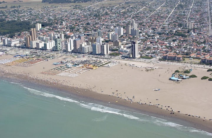
Necochea is one of the great seaside towns of the Buenos Aires Atlantic coast, in the southeast of the province, at the mouth of the Quequén Grande River on the Atlantic Ocean. Together with its sister town Quequén — separated by the river and joined by bridges — it forms a coastal conurbation known for its enormously wide beaches, of firm sand and kilometers of length, where you can walk, cycle or even drive along some stretches. It's a classic summer destination for families, quieter and less crowded than Mar del Plata.
The town's great natural emblem is Parque Miguel Lillo, a huge pine and eucalyptus forest planted in the early 20th century that runs parallel to the shore for hundreds of hectares, with lagoons, trails, museums and picnic areas. That 'green lung' facing the sea gives Necochea an identity of its own: the combination of forest and beach. On the Quequén side is the deep-water port — one of the country's main grain ports — plus the area of cliffs and the lighthouse, along with wilder beaches with waves, popular with surfers.
This guide covers the essentials of Necochea with a practical eye: its beaches and beach clubs, Parque Miguel Lillo, the port and cliffs of Quequén, water and adventure activities on the river and the sea, where to eat and stay, and how to get there and get around. It's an ideal destination for anyone after the Argentine seaside in family mode, with nature, sport and the calm of a coastal town on a human scale.
Necochea was founded in 1881 by Ángel Murga, on land in the south of Buenos Aires province, and bears the name of General Mariano Necochea, a hero of the wars of independence. Its growth was tied to the grain farming of the pampa, to the port of Quequén and, in the 20th century, to the development of beach tourism and the planting of Parque Miguel Lillo, which honors the famous Tucumán botanist. The full story is on our history page.
Read the full history ↓The agro-export heart of Argentina: the endless pampa that was the land of the Querandí and the Pampa peoples, the domain of governor Rosas, the engine of cattle and wheat with La Plata as its purpose-built capital, cradle of the gaucho and of the Atlantic Coast where the whole country spends its summer.
Read the history of Buenos Aires Province →A local guide tells you in half an hour what no sign at the site will ever explain. We look ours up on Civitatis: guided in Spanish and booked online with no fuss. They have 4 activities in Mar Del Plata. And there are free tours here: you book without paying and tip the guide whatever you think at the end, so trying one costs you nothing. Have a look below: tap any of them to see them all.
They depart from Mar Del Plata, 121 km away. If you book from this link we earn a commission and you pay no more.
No exact prices: a scale from $ (budget) to $$$$$ (luxury), with 2-3 options per category.
Origins, formation and what the sources say.
Few Argentine seaside towns can say they carry the surname of a general who fought alongside San Martín in the Andes and in Peru. Necochea can: and that choice, far from a whim, sums up the spirit in which this town in the southeast of Buenos Aires province was born. It was formally founded on October 12, 1881, when Ángel Murga pushed for its creation on land in the southeast of the province, on the bank of the Quequén Grande River, near its mouth on the Atlantic Ocean. The choice of site was no accident: the river offered fresh water and a natural point of communication with the interior of the pampa, and the area was part of the southern frontier that the Argentine state was finishing incorporating after the Conquest of the Desert, the military campaign that in those years displaced the native peoples — chiefly Ranquel and Mapuche communities — and opened the humid pampa to farming and ranching settlement.
The town's name honors General Mariano Necochea, a distinguished soldier of the South American wars of independence, who fought in the campaigns of the Army of the Andes alongside San Martín, took part in the battle of Chacabuco and also fought in the liberating campaigns of Peru under Bolívar. Naming the new town after a hero of independence followed the custom of the time — repeated in dozens of Buenos Aires towns founded in those years — of fixing the nation's memory and the symbols of the country being formed onto newly incorporated territory.
The first years were those of a frontier and farming town, with a scattered population, scant infrastructure and a fledgling economy tied to the land: estancias, smallholdings and the first urban plots around the founding square. The arrival of the railway, in the following decades, was decisive in connecting Necochea with Buenos Aires and the rest of the Pampas region, accelerating its growth in population and trade. The closeness of the river and the sea, however, would mark the town's double destiny from the start: the farming production of the humid pampa and, in time, the port and coastal tourism. Quequén, on the far side of the river, would grow in parallel as a sister town and port, shaping a coastal conurbation with two complementary souls.
The development of Necochea and Quequén is inseparable from the Quequén Grande River and its mouth, where one of the most important deep-water ports in Argentina was built. The pampa surrounding the town is one of the country's most productive grain and oilseed regions, and from the late 19th and early 20th centuries the region was folded into the Argentine agro-export model, based on producing grain — wheat, maize, later soy and sunflower — and shipping it to international markets, chiefly Europe.
The port works, with their long stone breakwaters protecting the ships' entrance from the Atlantic surf — a considerable feat of engineering for the time, which took decades of successive extensions — turned Quequén into a natural outlet for the production of the southern province. The movement of trucks loaded with grain, the silos, the grain elevators and the big bulk carriers became part of the landscape and the local economy, and also created a community of dockworkers, stevedores and families tied to maritime work that gave Quequén a social identity of its own, distinct from the more touristic life of Necochea. Even today, Puerto Quequén is one of the country's main grain export ports, able to handle deep-draft ships, which makes the region a key logistical hub for Argentine agriculture and one of the economic engines of the whole southeast of the province.
That agro-port base gave Necochea an identity different from that of other seaside towns that arose purely from tourism: here, the sea was first a route of trade and work before it was a summer destination. The coexistence of the working port in Quequén and the tourist beaches in Necochea defines the dual character of this coastal conurbation, something still visible today to any visitor: you only have to cross the bridge over the Quequén Grande to go from the family beach to the industrial scene of grain elevators and grain ships maneuvering in the access channel.
One of the most far-reaching decisions in Necochea's history was the planting of the coastal strip, in what is today Parque Miguel Lillo. In the early 20th century, the live dunes of the shore threatened to advance over the town, driven by the Atlantic wind, a problem common to much of the Buenos Aires coast before the great planting schemes. To fix them and, at the same time, create a recreational space, a mass planting of maritime pines, eucalyptus, acacias and other species resistant to wind and salt was undertaken, giving rise in time to one of the most extensive planted forests on the Argentine Atlantic coast, covering several hundred hectares. The park bears the name of the naturalist, botanist and pharmacist Miguel Lillo, a key figure in Argentine natural science in the early 20th century and founder of the institute that carries his name in Tucumán.
That great forest beside the sea proved decisive for the town's tourist development: it offered shade, coolness and a singular landscape — a forest reaching almost to the sand of the beach — that set Necochea apart from other resorts on the coast, where the sun beats down without relief. Through the 20th century the town established itself as a family summer destination, with the building of hotels, beach clubs, the seafront, the layout of internal streets within the park itself and tourist infrastructure in general, in step with the boom in beach tourism that Argentina experienced from the 1930s and 1940s, when the country's middle and working classes began to take summer holidays en masse.
Inside Parque Lillo, artificial lagoons for boat rides were added over the years, along with a forestry nursery, signposted trails, a small zoo — now converted into a conservation space — and several themed museums, among them one devoted to marine wildlife and another to local history. The combination of wide beaches of firm sand, the forest of Parque Lillo, the river with its water activities and the port of Quequén made Necochea a complete tourist destination with a quieter profile than other crowded centers on the coast. Today the town keeps that balance between year-round port and farming life and the buzz of summer tourism, faithful to the double vocation — productive and recreational — it has had since its founding in 1881, when the independence general who gave it its name could hardly have imagined that his surname would end up associated with one of the great coastal forests of Argentina.
The Quequén coast keeps a secret that few holidaymakers imagine while they sunbathe: under its waters and on its beaches lie the remains of a genuine ship graveyard. Along the roughly six kilometers running from the port's north breakwater to Costa Bonita beach, the traces pile up of wrecks and groundings that punctuated more than a century of difficult navigation, when the entrance to the port — battered by southeasterly storms, sandbanks and treacherous surf — was a trial by fire for captains. Local memory records the sailing ship El Filántropo as the first documented wreck on this coast, and the list kept growing for decades.
The answer to that danger was the Faro Quequén, lit for the first time on November 1, 1921: a tower 34 meters high — standing 64 meters above sea level — with a spiral staircase of 163 steps, which has guided the ships approaching the grain port ever since. But not even the lighthouse could prevent every tragedy. On April 1, 1924, a hurricane-force storm caused a double disaster: the English steamer Wesbury was wrecked in the Punta Negra area and, the same day, the Italian steamer Montepasubio ended up aground at Quequén, driven ashore by the wind. A decade later, 1934 was another black year: on November 12 the Greek steamer Marionga J. Goulandris ran aground and just sixteen days later, on the 28th, so did the Maroula, carrying a cargo of paving stones.
These rusting hulks, some still visible on the beach at low tide and others submerged offshore, became over time part of the landscape and the identity of Quequén: the setting for local legends, a point of interest for divers and anglers, and in recent years even the subject of a tourist circuit covering the sunken ships of Necochea and Quequén. For the visitor, walking the beach from the north breakwater towards Costa Bonita in search of the wrecks, with the century-old lighthouse as a backdrop, is one of the most singular experiences this corner of the Atlantic coast offers: an open-air museum of the age when reaching port was still a small epic.