Viajá con Gus
HomeDominican RepublicLake Enriquillo
Lake Enriquillo
🇩🇴 Dominican Republic · Southwest (Barahona)

Lake Enriquillo

Jump to what you need
📌Province
Lake Enriquillo stretches between the provinces of Independencia and Bahoruco, in the southwest of the Dominican Republic, within the Enriquillo basin or depression, in the heart of the Neiba valley. It's the largest lake in the insular Caribbean and its surface is about 40–45 meters below sea level, the lowest point in the Antilles
📌Service city
The village of La Descubierta, on the northwest shore, is the usual base for the park excursions; it has very basic services. For more comfort, most visitors stay overnight in Barahona (1.5–2 h away) or in Neiba, cities with more hotels, banks and restaurants. Jimaní, on the border with Haiti, is also near the lake
📌Best time to go
The dry season (November to April) is the most recommended, with somewhat less extreme heat and roads in better condition. The Dominican southwest is one of the hottest and driest areas of the country all year round, so it's best to set out very early at any time to avoid the worst heat and see the most active wildlife
📌Suggested days
1 day is enough for the boat excursion to Cabritos Island and a stop at Las Caritas de Los Indios. If you combine it with Barahona, Bahoruco or a getaway to Pedernales and Jaragua National Park, it's best to add 1 or 2 more days to make the most of the Dominican southwest, one of the least-visited and most singular regions in the country
💱 DOP exchange rate
Loading rate…
🌤️ Weather in Lake Enriquillo
Loading weather…

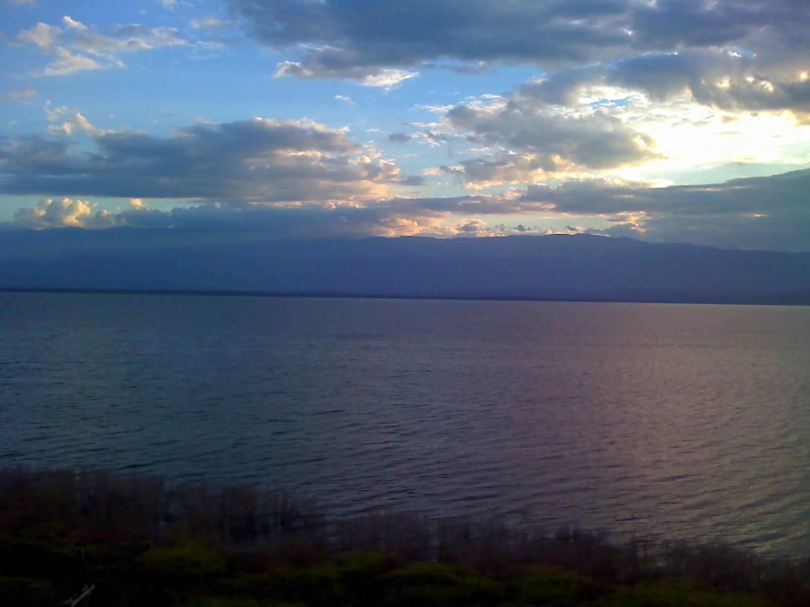
Lake Enriquillo is the largest lake in the insular Caribbean and one of the most singular places in the whole Dominican Republic. Located in a depression in the southwest, in the heart of the Neiba valley, its surface lies below sea level (the lowest point in the Antilles), which makes it a geographic rarity. Its waters are hypersaline —saltier than the sea— because the lake has no outlet and the water is lost only through evaporation under the relentless sun of the region.

Beyond the record, what fascinates the traveler is its wildlife. The lake is home to the country's largest population of American crocodile, along with rhinoceros iguanas and Ricord's iguanas, two endemic and threatened species that can be seen on Cabritos Island, the islet in the center of the lake protected as a national park. Flamingos and other aquatic birds complete an arid and dazzling ecosystem, surrounded by cacti, rock walls and a characteristic dry heat.

Lake Enriquillo bears the name of the Taíno cacique Enriquillo, a symbol of Indigenous resistance to the Spanish in the 16th century. Visiting it means glimpsing an almost lunar landscape, full of resilient life, and one of the most remembered pages of Dominican history. This guide gathers the practical details for getting to know it: how to get there, what to see, how much the excursion to Cabritos Island costs and what to keep in mind in a remote area with an extreme climate.

📖 History of Lake Enriquillo

The lake owes its name to Enriquillo, a Taíno cacique who led a long rebellion against the Spanish in the early 16th century and ended up signing a peace treaty with the Crown around 1533. The depression where it lies was once an arm of the sea that became isolated, leaving a salt lake below the level of the ocean. Its level has fluctuated drastically in recent decades —it almost doubled its surface between 2000 and 2010— flooding lands and roads. The full story is on our history page.

Read the full history ↓

🏛️ Lake Enriquillo is in Independencia

A southwestern border province on the shores of Lake Enriquillo, the largest and lowest lake in the Caribbean; land of the ancient chiefdom of Jaragua, of the international crossing at Jimaní and of the memory of the Blanco River disaster of 2004.

Read the history of Independencia →

🗺️ What to see

1
Cabritos Island (Lake Enriquillo and Cabritos Island National Park)
An islet in the center of the lake, a refuge for crocodiles, endemic iguanas and birds.
Cabritos Island is the heart of the national park and the main objective of the visit. It's a low, arid island, covered in cacti and dry-scrub vegetation, that rises in the middle of the salt lake. To get there you sail by boat from the shore, on a trip that is already part of the experience, with the water reflecting the barren mountains around it. The island is a wildlife sanctuary. Here lives a large population of American crocodile, which can be observed especially on the shores and at the freshwater inlets, particularly early in the morning, when the animals bask in the sun. Two species of endemic and threatened land iguana also live here: the rhinoceros iguana and Ricord's iguana, which often come up to visitors. Herons, flamingos and other birds complete the spectacle. The tour is done with park rangers or local guides, and it's best to book it with an authorized operator. Getting there: by boat from the park's pier, near La Descubierta. Best time: dry season; a very early departure to see active crocodiles and avoid the heat. Tips: bring plenty of water, a hat, sunscreen and closed footwear; the sun and heat are intense and there's little shade.
ℹ️ Distance: The park's pier, near La Descubierta (access only by boat) · Best time to go: Dry season (November–April); set out very early · Entry: The park entry is only charged if you take the boat trip; access to the shore is free. The official rate published by the Ministry of the Environment is RD$ 100 per person for any protected area in the country, and the rangers usually ask a separate ~RD$ 100 to watch the car (that second charge appears in no official rate sheet). Most of the cost is the boat (source: Ministry of the Environment RD and visitor reviews, verified July 2026) · Duration: 2 to 3 hours (boat trip and island)
2
American crocodile watching
The lake has the country's largest population of American crocodile.
The American crocodile (Crocodylus acutus) is the great emblem of Lake Enriquillo. Its brackish waters and the freshwater inlets of the rivers that feed the lake offer an ideal habitat, and the largest population of the species in the Dominican Republic concentrates here. Seeing them in the wild, at a prudent distance and always with a guide, is one of the most memorable experiences of the southwest. The crocodiles are best observed early in the morning, when they come out to bask on the shores and sandbanks. During the day, with the heat, they usually go into the water. That's why the excursions set out very early. The guide knows the spots where they're most likely to be found and respects the safety distances. Getting there: on the boat excursion across the lake and Cabritos Island. Best time: dry season; sunrise. Tips: a camera with good zoom, patience and silence; never approach on your own or feed them.
ℹ️ Distance: Within the boat excursion across the lake · Best time to go: Sunrise, dry season · Entry: Included in the excursion to Cabritos Island (verified July 2026) · Duration: Part of the 2–3 hour excursion
3
Las Caritas de Los Indios
Taíno petroglyphs carved in the rock with a panoramic view of the lake.
A few kilometers from La Descubierta, next to the road that hugs the lake, are Las Caritas: a set of Taíno petroglyphs carved into a limestone rock wall, with faces and figures engraved by the pre-Columbian inhabitants of the area. A short stairway cut into the rock leads to the natural viewpoint. From the top you get one of the best panoramic views of Lake Enriquillo, with its waters stretching toward the mountains. The place combines archaeological with scenic interest and is a usual stop before or after the boat excursion. Tradition links the site with the Taíno presence and with the figure of the cacique Enriquillo. Getting there: along the lake road, near La Descubierta, with a signpost. Best time: any time of day, better when the sun is not so high. Tips: the climb is short but steep; comfortable footwear and water.
ℹ️ Distance: Next to the road near La Descubierta · Best time to go: Any time; better when the sun is not so high · Entry: Free or a voluntary contribution (verified July 2026) · Duration: 20 to 30 minutes
4
La Descubierta and its swimming spot
A shore village with a cool-water swimming spot, the base for the excursions.
La Descubierta is the village that serves as the base for visiting the lake, on the northwest shore. It's a quiet town of the Neiba valley, with basic services, some very simple lodging and local eateries. The excursions to the park and Cabritos Island leave from here. The town is known for its Las Barías swimming spot (Los Borbollones), a spring of fresh, cool water that wells up from underground and forms a natural pool surrounded by trees, much appreciated for cooling off from the valley's heat. It's a pleasant contrast with the aridity of the lake's surroundings. Getting there: La Descubierta is on the road that circles the lake, accessible from Neiba and Jimaní. Best time: year-round; the swimming spot is ideal on hot days. Tips: bring cash, a swimsuit and insect repellent.
ℹ️ Distance: Base village on the northwest shore of the lake · Best time to go: Year-round; swimming spot ideal on hot days · Entry: Usually free or with a token contribution (RD$ 50–100) depending on the season (verified July 2026; check when visiting) · Duration: 1 to 2 hours
5
Roadside viewpoint and the landscape of the Enriquillo basin
Panoramic views of the lake and the lowest depression in the Caribbean, on the way from Neiba or Jimaní.
The route along the road that hugs Lake Enriquillo, between Neiba, La Descubierta and Jimaní, offers several natural viewpoints from which you can appreciate the magnitude of the Enriquillo basin: the lowest depression in the insular Caribbean, with the lake stretching between barren mountains and an almost desert landscape dotted with columnar cacti and thorny vegetation. Most excursions organized from Santo Domingo or Barahona include a photo stop at one of these panoramic points before going down toward the pier. The light of sunrise or sunset, with the tones of the salt water and the arid mountains, offers a natural spectacle very different from the Caribbean of beaches and palm trees. It's a good moment to grasp the scale of the geological phenomenon: a hypersaline lake more than 40 meters below sea level, surrounded by an extreme climate, that continues to surprise geologists and biologists with its uniqueness in the whole region. Getting there: on the road route from Neiba, Barahona or Jimaní toward La Descubierta. Best time: sunrise or sunset for the best light. Tips: bring a camera, water and sun protection; the heat on the road can be intense at midday.
ℹ️ Distance: On the road between Neiba, La Descubierta and Jimaní · Best time to go: Sunrise or sunset (best light) · Entry: Free (roadside viewpoint) · Duration: 15 to 30 minutes
6
Combined excursion with Barahona and the Sierra de Bahoruco
Combining the lake with the Barahona coast and the mountains where the cacique Enriquillo took refuge.
Lake Enriquillo combines very well with the rest of the Dominican southwest, one of the country's richest in nature and least-visited regions. Many travelers combine the lake excursion with Barahona, the coastal city that serves as the gateway to the southwest, with its pebble beaches, and with the Sierra de Bahoruco, the range where the cacique Enriquillo took refuge during his rebellion in the 16th century and today protected as a national park, with cloud forest and exceptional biodiversity. This combination lets you get to know, in a few days, several contrasting ecosystems: the hypersaline lake below sea level, the beaches of the southwest Caribbean and the misty mountains of Bahoruco, all within the same uncrowded region with a strong character of unspoiled nature. The agencies of Santo Domingo and Barahona offer multi-day packages that integrate these destinations, with guides specialized in the wildlife and geography of the southwest. Getting there: in your own car or with tour operators who arrange the combined itinerary from Santo Domingo or Barahona. Best time: dry season (November–April). Tips: book in advance if you go with an operator; if you go on your own, bring good footwear and check the state of the mountain roads.
ℹ️ Distance: Barahona 1.5–2 h from La Descubierta; Sierra de Bahoruco in the same region · Best time to go: Dry season (November–April) · Entry: Depending on the combined itinerary (verified July 2026; check with the operator) · Duration: 2 to 3 days for the full combination
Advertisements
What nobody tells you

💵 Prices

Tickets

TypePrice
Entry to Lake Enriquillo and Cabritos Island National ParkRD$ 100 per person: this is the single protected-area entry fee published by the Ministry of the Environment («Permiso de entrada a las Áreas Protegidas», Cost: RD$100 p/p); in practice it is only charged if you take the boat trip, and separately the rangers usually ask ~RD$ 100 to watch the car, which is NOT an official rate (official source: https://ambiente.gob.do/permiso-de-entrada-a-las-areas-protegidas/, consulted 10/08/2026)
Boat excursion to Cabritos Island (with guide, from the pier)RD$ 2,500–4,000 per boat (group of up to 6–8 people) approx. (verified July 2026; check at the pier)
Organized full-day excursion from Barahona or Santo DomingoFrom US$ 78 per person from Barahona (Civitatis, 8 h with boat, guide and transfer); US$ 90–140 from Santo Domingo (source: Civitatis, verified July 2026)
Las Caritas de Los IndiosFree or a voluntary contribution (verified July 2026)
La Descubierta swimming spot (Las Barías / Los Borbollones)Free or a token contribution RD$ 50–100 (verified July 2026)
🔄 updated monthlyOfficial / reference values · double-check when buying

Activities and tours

ActivityPriceDurationOperator
Boat excursion across the lake and Cabritos Island (from the pier)RD$ 2,500–4,000 per boat, group of up to 6–8 people (verified July 2026)Half a day (2–3 h)Park rangers / local operators in La Descubierta
Organized full-day excursion from Barahona or Santo DomingoFrom US$ 78 from Barahona (Civitatis); US$ 90–140 from Santo Domingo (verified July 2026; transport, guide and boat included)Full day (8 h from Barahona; 10–12 h from Santo Domingo)Civitatis, Larimar EcoTour, Barahona agencies
Crocodile watching at sunriseIncluded in the boat excursion2–3 hLocal La Descubierta guides
Iguana and bird watchingIncluded in the excursionVariableLocal guides
Swim at the La Descubierta spot (Las Barías)Free or a token contribution RD$ 50–100 (verified July 2026)FreeOn your own
🔄 updated monthlyOfficial / reference values · double-check when buying
Advertisements

🚌 How to get there and distances

Getting around

ModePriceDurationNotes
Park boat (Cabritos Island pier)RD$ 2,500–4,000 per boat (group, verified July 2026)2 to 3 hours of touringThe main way to reach Cabritos Island; booked at the visitor center, about 3 km east of La Descubierta. CASH PAYMENT (Dominican pesos); there's no app or card
Own or rental car / vehicleRental from US$ 35–50/day + fuel (verified July 2026)VariableIt's the most practical way to tour a remote area. The road hugs the lake; it's best to fill up on fuel in Barahona or Neiba before going, because there are few stations. There's no Uber/InDrive in the area
Intercity guaguas and motoconchosRD$ 80–250 depending on the trip; short motoconcho RD$ 50–100 (verified July 2026)VariableThe guaguas connect Barahona, Neiba, Jimaní and La Descubierta; PAID IN CASH to the driver, in pesos, with small bills. There's no rechargeable card or payment app. Within La Descubierta, the motoconchos cover short trips (agree on the price beforehand)
Transport and bus-location appsApp free; trip separateVariableThere's no real-time tracking app for the southwestern guaguas (they have no public GPS). Google Maps and Moovit only partially help you orient yourself on the route; in practice you ask at the stop or book the excursion. For the long-distance buses to Santo Domingo/Barahona it's best to use the Caribe Tours website (verified July 2026)
🔄 updated monthlyOfficial / reference values · double-check when buying

How to get there

RouteAirlines / operatorsAvg. priceDuration
Santo Domingo → La Descubierta (via Barahona or Azua-Neiba)Car, Caribe Tours to Barahona/Neiba + local guagua with transfersRD$ 400–600 by guagua with transfers (verified July 2026)Approx. 4 to 5 h (more than 200 km)
Barahona → La DescubiertaCar, local guaguasRD$ 150–250 by guagua (verified July 2026)Approx. 1.5 to 2 h
Jimaní (border with Haiti) → La DescubiertaCar, local transportRD$ 80–120 (verified July 2026)Approx. 40 min to 1 h
🔄 updated monthlyOfficial / reference values · double-check when buying

🏨 Where to stay

No exact prices: a scale from $ (budget) to $$$$$ (luxury), with 2-3 options per category.

CategoryPriceRecommended options
Very basic lodging in La Descubierta$$$$$US$ 10–20 per night; e.g. Iguana Hotel, very simple, without tourist rating. Handy only for an early start to the excursion (verified July 2026)
Budget hotels in Barahona$$$$$US$ 25–40 per night; simple options in the city, with more services than La Descubierta (verified July 2026)
Mid-range and seafront hotels in Barahona$$$$$US$ 60–120 per night; e.g. Hotel Caribe, Hotel El Quemaito, with a pool and closeness to pebble beaches. The most recommended option for staying overnight and doing the excursion during the day (verified July 2026)

🍴 Where to eat

TypePriceOptions / signature dish
Local eateries (Creole Dominican cuisine)$$$$$US$ 5–12 per dish; the Dominican bandera (rice, beans, meat), fish and stewed goat at eateries in La Descubierta and Neiba (verified July 2026)
Goat (typical of the southwest)$$$$$US$ 8–15 per dish; the goat of the dry southwest region is a specialty; served stewed or roasted, highly recommended (verified July 2026)
Fried snacks and roadside food$$$$$US$ 2–6; fried snacks, empanadas and soft drinks at village stalls, ideal before or after the excursion (verified July 2026)
Advertisements

📖 History of Lake Enriquillo

Origins, formation and what the sources say.

A trapped sea: the lake's geological origin

Standing on the shore of Lake Enriquillo, you're at the lowest point in the whole insular Caribbean: about forty meters below sea level, with the salt water stretching toward barren mountains and cacti, and crocodiles basking in the distance. It's hard to believe that this hypersaline lake, saltier than the ocean, was once part of the open sea. But it was: if you climb the hills that surround it, you can still find fossilized shells and corals embedded in the rock, the stony proof of an underwater world that became trapped on dry land.

Lake Enriquillo occupies the bottom of one of the deepest depressions in the Antilles, in the Neiba valley, a long tectonic trough that crosses the southwest of the island of Hispaniola from east to west. This depression is the continuation, on Dominican soil, of the same geological fault that in Haiti forms the Cul-de-Sac plain and Lake Azuéi (or Étang Saumâtre). Geologically, this whole strip was in the past a marine channel connecting the Atlantic Ocean with the Caribbean Sea, separating what were then two distinct islands.

Over time, tectonic movements and the accumulation of sediment closed that channel at both ends, leaving a body of marine water trapped. Isolated from the sea and under a hot, dry climate, the lake began to lose water through evaporation faster than it received it, which lowered its level below the sea and concentrated the salts. Today Lake Enriquillo is hypersaline —at many times saltier than the ocean itself— and its surface marks the lowest point in the whole insular region of the Caribbean.

That marine origin also explains the presence of ancient fossilized coral reefs and shells in the hills surrounding the lake, stony testimonies of when all that was under salt water. The resulting landscape is arid and almost desert-like, dominated by cacti, thorny scrub and saline soils, in strong contrast with the tropical image usually associated with the Caribbean.

The cacique Enriquillo and Taíno resistance

The lake bears the name of Enriquillo, one of the most famous figures in the early history of the Dominican Republic. Enriquillo was a Taíno cacique born at the end of the 15th century, educated by Franciscan friars after the Spanish conquest of Hispaniola. Like so many Indigenous people, he was subjected to the encomienda system, which distributed the natives to work in the service of the settlers under conditions of virtual slavery.

Around 1519, fed up with the abuses he and his people suffered, Enriquillo rebelled and took refuge with his followers in the mountains of the Sierra de Bahoruco, which overlook the lake's surroundings. From there he maintained an armed resistance for years against the Spanish expeditions sent to subdue him, taking advantage of the rugged terrain and his knowledge of the territory. His rebellion became a symbol of dignity against colonial abuse.

Finally, around 1533, the Spanish Crown chose to negotiate. Enriquillo signed a peace treaty that recognized freedom and certain guarantees for him and his people, an exceptional event for the time. His figure was immortalized centuries later by the Dominican writer Manuel de Jesús Galván in the novel 'Enriquillo' (1882), which enshrined him as a national hero. Giving his name to the great lake of the southwest was a way of fixing in the geography the memory of that Indigenous resistance.

Enriquillo, between history and myth
The figure of Enriquillo combines documented facts (the rebellion in the Sierra de Bahoruco and the peace treaty of around 1533) with a later literary and nationalist idealization, especially from Galván's novel. The specific details of his biography are reconstructed from chronicles like those of Bartolomé de las Casas.
Source: https://es.wikipedia.org/wiki/Enriquillo

A wildlife sanctuary: the national park

Despite its arid setting and the salt of its waters, Lake Enriquillo and Cabritos Island are home to remarkable biodiversity, to the point of being declared a national park to protect it. The star is the American crocodile (Crocodylus acutus), which finds here, at the freshwater inlets that feed the lake, one of its main refuges in the Caribbean. The lake's crocodile population is the most important in the country.

Cabritos Island, an arid islet covered in cacti in the center of the lake, is also home to two species of land iguana endemic to Hispaniola and threatened with extinction: the rhinoceros iguana (Cyclura cornuta) and Ricord's iguana (Cyclura ricordii). The park also protects a rich birdlife —flamingos, herons and migratory birds— that makes use of the shores and the brackish wetlands.

The ecological value of the place has earned it international recognition: the area is part of zones designated for the conservation of wetlands and biosphere reserves of the Dominican southwest. Visiting the park, always with guides and respecting the rules, is a way to support the conservation of a fragile and unique ecosystem, where very vulnerable species survive in a delicate balance with an increasingly extreme climate.

A lake that rises and falls: the recent fluctuations

One of the most striking characteristics of Lake Enriquillo is the dramatic variation of its level over time. Being a closed lake, with no outlet to the sea, its size depends on the fragile balance between the water it receives from rains and rivers and the water it loses through the valley's intense evaporation. Small changes in that balance translate into large changes in surface area.

Between the first decade of the 2000s and the beginning of the 2010s, the lake experienced a spectacular rise: its surface nearly doubled, flooding agricultural lands, roads, homes and entire palm groves on its shores. Images of dead palm trees poking out of the water became a symbol of the phenomenon. The causes were attributed to a combination of intense rains, changes in the land use of the basin and possible effects of climate change, though the exact explanation remains a subject of study.

That rise forced the relocation of communities and severely affected the local economy. In subsequent years the level partly fell again. This ebb and flow makes Lake Enriquillo a natural laboratory for studying the response of ecosystems and human populations to climate variability, and reminds the visitor that they're facing a living, changing body of water, far from the stillness of the postcards.

The causes of the lake's rise
The notable rise in Lake Enriquillo's level in the 2000s–2010s has been attributed to a mix of factors: increased rainfall, changes in the basin and deforestation, and possible effects of climate change. The exact proportions of each factor are still debated by specialists.
Source: https://es.wikipedia.org/wiki/Lago_Enriquillo

The people of the valley: from neglect to ecotourism

The Lake Enriquillo region has for centuries been one of the most forgotten and least-populated in the Dominican Republic: a hot, saline and isolated valley, far from the centers of power of Santo Domingo and from the routes of sugar and sun-and-beach tourism. Towns like La Descubierta, Neiba, Duvergé or Jimaní grew with a subsistence economy based on rain-fed agriculture, goat herding —the famous goat of the dry region— and, more recently, the production of plantain, grapes and other crops where irrigation allows.

The closeness to Haiti also shapes the area's life. Jimaní, on the border, is one of the main land crossings between the two countries that share the island, with intense binational trade and a very active border market. That status as a borderland, a mix of cultures and languages, is part of the identity of the deep southwest, very different from that of the touristy east.

The great rise of the lake between 2004 and 2013 hit these communities head-on: the water swallowed thousands of hectares of crops and stretches of road, and forced families to relocate and roads to be rebuilt. That episode put Lake Enriquillo in the national headlines and drew the attention of scientists from all over the world. In parallel, the recognition of the park's natural value —crocodiles, endemic iguanas, birds— gradually opened a new path: ecotourism. Today, although it remains a niche destination, the lake receives more and more travelers interested in nature and history, and the excursions to Cabritos Island have become a source of income for the guides and families of La Descubierta. The challenge is for that tourism to grow without harming the fragile ecosystem that makes it unique.

📚 Bibliography

  • Wikipedia (ES) — «Lago Enriquillo»: https://es.wikipedia.org/wiki/Lago_Enriquillo
  • Wikipedia (EN) — «Lake Enriquillo»: https://en.wikipedia.org/wiki/Lake_Enriquillo
  • Wikipedia (ES) — «Hoya de Enriquillo»: https://es.wikipedia.org/wiki/Hoya_de_Enriquillo
  • Wikipedia (ES) — «Parque nacional Lago Enriquillo e Isla Cabritos»: https://es.wikipedia.org/wiki/Parque_nacional_Lago_Enriquillo_e_Isla_Cabritos
  • Wikipedia (EN) — «Isla Cabritos National Park»: https://en.wikipedia.org/wiki/Isla_Cabritos_National_Park
  • Wikipedia (ES) — «Enriquillo»: https://es.wikipedia.org/wiki/Enriquillo
  • Wikipedia (ES) — «Sierra de Bahoruco»: https://es.wikipedia.org/wiki/Sierra_de_Bahoruco
  • Wikipedia (ES) — «La Descubierta»: https://es.wikipedia.org/wiki/La_Descubierta
  • Wikipedia (ES) — «Jimaní»: https://es.wikipedia.org/wiki/Jiman%C3%AD
  • Ministerio de Medio Ambiente y Recursos Naturales (RD) — Parque Nacional Lago Enriquillo: https://ambiente.gob.do/parque-nacional-lago-enriquillo/
  • Lonely Planet — Parque Nacional Lago Enriquillo & Isla Cabritos: https://www.lonelyplanet.com/points-of-interest/parque-nacional-lago-enriquillo-isla-cabritos/1182966

❓ Frequently asked questions

Why is Lake Enriquillo famous?+
It's the largest lake in the insular Caribbean and lies below sea level, the lowest point in the Antilles. Its waters are hypersaline and it's home to the country's largest population of American crocodile, plus endemic iguanas (rhinoceros and Ricord's) on Cabritos Island. It's an arid and unique landscape.
Can you see crocodiles and how much does the excursion cost?+
Yes. The lake has the largest population of American crocodile in the Dominican Republic (about 200 individuals). They're best observed at sunrise, always from the boat and with a guide. The boat excursion from the pier costs between RD$ 2,500 and 4,000 per group (verified July 2026); if you prefer an organized excursion, from Barahona there are 8-hour tours from US$ 78 per person (Civitatis), and from Santo Domingo, a full day with transfer, guide and boat, between US$ 90 and US$ 140.
How do you get there and where do you sleep?+
The base is the village of La Descubierta, on the northwest shore, reached from Barahona, Neiba or Jimaní. There's very simple lodging in the village from about US$ 10; many travelers prefer to sleep in Barahona (from US$ 25), with more options, and do the excursion during the day. From Santo Domingo it's about 4–5 hours.
What should you bring?+
Plenty of water, a cap or hat, sunscreen, insect repellent and closed footwear. The climate is very hot and dry, with little shade. It's best to set out early for the excursion, both because of the heat and the wildlife activity.
Who was Enriquillo?+
Enriquillo was a Taíno cacique who in the early 16th century led a long rebellion against the abuses of the Spanish settlers, taking refuge in the mountains of the Sierra de Bahoruco. He ended up signing a peace treaty with the Crown around 1533 and is considered a symbol of Indigenous resistance; the lake bears his name.
What's the best time to visit it?+
The dry season (November to April) is the most recommended, with a little less heat and roads in better condition. In any case, the southwest is hot all year, so it's best to start early.
Is it better to go on your own or with an organized excursion?+
If you have a car and want flexibility, going on your own to La Descubierta and booking the boat at the pier (RD$ 2,500–4,000 per group) is cheaper. If you prefer not to drive and to have everything handled (transfer, guide and boat), an organized excursion from Barahona (from US$ 78, 8 h) or from Santo Domingo (US$ 90–140, a long 10–12 h day) is more convenient (verified July 2026).
How do I get around the area and how do you pay for transport?+
The area is remote and the most practical way is a car (own or rented from US$ 35/day): fill up on fuel in Barahona or Neiba beforehand, because there are few stations. The intercity guaguas connect Barahona, Neiba, Jimaní and La Descubierta, and the motoconchos cover short trips within the village: EVERYTHING is paid in cash, in Dominican pesos and with small bills, directly to the driver. There's no rechargeable card, payment app or Uber/InDrive in the southwest, and the local guaguas have no real-time tracking on Moovit or Google Maps; for the long-distance buses to Santo Domingo you use Caribe Tours (verified July 2026).
Sources consulted (11)
Still planning?
Explore more destinations in Dominican Republic
See all destinations →
Advertisements
Image credits
Photos from Wikimedia Commons, each under its own licence (CC BY, CC BY-SA or public domain). Open each file to see its author and licence.
Lago Enriquillo

