Viajá con Gus
HomePuerto RicoGuánica
Guánica
🇵🇷 Puerto Rico · South

Guánica

Jump to what you need
📌Municipality
Guánica is a municipality on the southwest coast of Puerto Rico, famous for the Guánica State Forest, one of the largest and best-preserved subtropical dry forest reserves in the world (a UNESCO Biosphere Reserve), and for its crystal-clear beaches and cays like Gilligan's Island. Its population is around 17,000-18,000. It also has a place in history: it was the landing point for US troops in 1898, during the Spanish-American War
📌Service town
Guánica has its own town and basic services, and it relies on nearby Ponce (about 30-40 minutes away) and other southern cities. San Juan's Luis Muñoz Marín International Airport (SJU) is about 1.5-2 hours away by car on the highway; Ponce's Mercedita regional airport (PSE) is about 30-45 minutes away. The way to get around is by car (your own or a rental); some attractions (cays, forest) are reached by boat or on trails
📌Best time to go
Dry, very sunny tropical climate (Guánica is one of the driest and hottest areas on the island; 27-33 °C). It's visited year-round; the dry season (December to April) is ideal. The dry forest is best enjoyed early in the morning, because of the heat. The southwestern sea is usually calm, perfect for swimming and snorkeling. Hurricane season runs from June to November; the south also suffered earthquakes in 2020
📌Suggested days
Guánica can be enjoyed in 1 to 2 days: a dry-forest day (trails and lookouts of the Guánica Forest) and another of beach and cays (Gilligan's Island, southwestern beaches). It's usually combined with Ponce, La Parguera (in neighboring Lajas) and the rest of the south and southwest on a regional route. It's a nature-and-sea getaway, ideal for those seeking the dry, sunny south of the island
💱 USD exchange rate
Loading rate…
🌤️ Weather in Guánica
Loading weather…

Guánica is a small municipality on the southwest coast of Puerto Rico that holds two very different treasures: one grayish-green and unique, and one turquoise and bright. The first is the Guánica State Forest, one of the largest and best-preserved subtropical dry forest reserves in the world, declared a Biosphere Reserve by UNESCO: a fascinating ecosystem of thorny trees, cacti, arid soils and a surprising biodiversity, very different from the humid rainforest of El Yunque.

The second treasure is its sea: the warm, crystal-clear waters of the southwest, with postcard beaches and cays like Gilligan's Island (Cayo Aurora), a small islet of mangroves and turquoise water reached by boat that is one of Puerto Ricans' favorite places to spend the day. To all that, Guánica adds notable historical weight: US troops landed on its coast in 1898, in the episode that forever changed the island's destiny.

This guide covers the essentials of Guánica with a practical, warm eye: its exceptional dry forest, its turquoise-water beaches and cays, its history and its nature. It's an essential destination in southern Puerto Rico for lovers of nature, the sea and singular landscapes, where you can walk through a unique dry forest in the morning and swim in crystal-clear waters in the afternoon, all under the warm southwestern sun.

📖 History of Guánica

Guánica, on the southwest coast, was inhabited by the Taíno; its name is of Indigenous origin. Tradition links the area with episodes of Taíno history and the first colonial times. During the Spanish colonial era, the region developed with agriculture (sugarcane) and lived tied to its bay. The municipality was formally established in the late 19th century (it split from Yauco; its founding as a municipality is placed around 1914, with earlier antecedents, according to the sources). The historical event that marked Guánica occurred on July 25, 1898: US troops under the command of General Nelson Miles landed in its bay, beginning the invasion of Puerto Rico during the Spanish-American War, an event that would lead to the change of sovereignty of the island. In the 20th century, the Guánica State Forest was protected for its exceptional ecological value as a dry forest, and was declared a Biosphere Reserve by UNESCO in 1981. The local economy was also tied to sugar (with a large sugar mill) and, later, to nature and beach tourism. In 2020, the southern area, including Guánica, was the epicenter of a series of earthquakes. Today Guánica is a destination of nature, beaches and history in the south of the island. The detailed history is on our history page.

Read the full history ↓

🗺️ What to see

1
Guánica State Forest (Biosphere Reserve)
One of the largest subtropical dry forest reserves in the world, with trails, lookouts and unique biodiversity.
The Guánica State Forest is the municipality's great natural treasure and one of the most valuable and singular ecosystems in Puerto Rico: one of the largest and best-preserved subtropical dry forest (also called tropical dry forest) reserves in the world. For its exceptional value, it was declared a Biosphere Reserve by UNESCO in 1981. It's the 'dry' counterpart to El Yunque: here there's no humid jungle, but an arid landscape of thorny trees, cacti, succulent plants and rocky soils, the result of the southwest's dry, hot climate. Far from seeming a barren place, the Guánica dry forest is home to a surprising biodiversity and many endemic and rare species, adapted to the harsh arid conditions: trees that shed their leaves in the drought, cacti, a remarkable variety of birds (it's a paradise for birdwatchers, with species like the endangered Puerto Rican nightjar), reptiles and unique plants. It's a living laboratory of adaptation to dryness. The forest has a network of trails of different levels (like the popular Cueva Trail, with karst formations) that cross the arid landscape, lead to lookouts with views of the Caribbean Sea and the coast, and let you discover its flora and fauna. Some trails reach hidden beaches and coves, combining forest and sea. It's a unique place for walking, birdwatching and understanding an uncommon ecosystem. Getting there: by car, to the forest entrances, in Guánica; well signposted. Best time and hours: early in the morning, because of the heat (the dry forest is very hot at midday); in the dry season for the trails. Tips: bring plenty of water, a cap, sunscreen and hiking shoes (there's little shade and lots of sun), start early, and take advantage of the birdwatching.
ℹ️ Distance: Forest entrances in Guánica (car, signposted) · Best time to go: Early morning (very hot at midday); dry season for the trails · Admission: Free (access and parking at no cost; managed by the DRNA, 2025) · Duration: Half a day
2
Gilligan's Island (Cayo Aurora)
A mangrove and turquoise-water islet reached by boat, the favorite for a beach day.
Gilligan's Island, whose official name is Cayo Aurora, is one of the most beloved places in Guánica and southern Puerto Rico for spending a beach day. It's a small cay or islet off the coast, formed by mangroves and surrounded by warm, shallow and crystal-clear turquoise waters, ideal for swimming, floating, snorkeling and relaxing. Its nickname, 'Gilligan's Island', evokes the famous TV show for its paradisiacal-islet air. The cay is made up of channels and small beaches among the mangroves, where the calm, clear water invites you to spend hours. It's very popular among Puerto Ricans, especially on weekends, who come with coolers, food and a desire to enjoy the sea. There are areas with natural shade from the mangroves and areas to sit in the water. It's reached by a short boat (ferry) crossing, managed by the DRNA, that leaves from the San Jacinto restaurant area, near the Copamarina Beach Resort. The islet has no major services (it's best to bring what you need), which preserves its natural, relaxed atmosphere. It's the perfect plan to combine with a visit to the dry forest. Getting there: by boat/ferry from the San Jacinto dock, in Guánica (check the schedule by calling, since the operator has little staff). Best time and hours: in the morning (first departures between 9 and 10 am; the return is usually at 5 pm) for a calmer sea and to get a spot; the cay is closed on Mondays. Tips: bring water, food, shade (an umbrella or parasol), reef-safe sunscreen and snorkel gear; don't leave trash so as to conserve the cay.
ℹ️ Distance: Cay off the coast of Guánica; ferry from the San Jacinto dock · Best time to go: Morning for a calm sea and a spot; closed on Mondays · Admission: US$9.59 round trip per person; cooler US$5.58 (DRNA ferry, 2025; confirm when you visit, tel. 787-821-4941) · Duration: Half a day or more
3
Beaches and southwest coast
Calm, warm-water beaches and coves, some accessible from the dry forest, perfect for swimming and snorkeling.
Besides Gilligan's Island, the Guánica coast offers calm, warm and crystal-clear beaches and coves, typical of the calm sea of southwestern Puerto Rico. Some of the most beautiful are precisely within or next to the Guánica State Forest, which lets you combine the dry-forest walk with a swim in the sea. Among them the Tamarindo Beach area stands out, along with other coves reached by forest trails, where the arid landscape of cacti and thorny trees suddenly gives way to turquoise waters: a beautiful and uncommon scenic contrast. These beaches are usually calm and natural, with good snorkeling in their rocky areas and reefs. There's also the Caña Gorda area, a public beach with services (restrooms, showers, picnic areas) next to the Copamarina Beach Resort. The southwestern sea, sheltered and calm, is ideal for swimming, snorkeling and enjoying with family, with less surf than the north or the west of the island. The combination of dry forest and turquoise-water beaches makes Guánica a very complete and singular nature destination. Getting there: depending on the beach, by car (Caña Gorda) or on forest trails (coves like Tamarindo). Best time and hours: in the morning for a calmer sea; in service-free areas, go prepared. Tips: for the forest coves, bring water, shade and everything you need (there are no services) and combine with the walk; use reef-safe sunscreen and respect the protected setting.
ℹ️ Distance: Guánica coast; Caña Gorda beach by car, coves via forest trails · Best time to go: Morning for a calm sea; in service-free coves, go prepared · Admission: Free (open-access public beaches; Caña Gorda beach with no parking charge, 2025) · Duration: Half a day or more
4
Snorkeling and diving in Guánica (The Wall)
Clear waters and reefs around the cays and coast, with corals, fish and good visibility; serious diving at 'The Wall'.
The calm, clear waters of Guánica, in the sheltered southwestern sea, are excellent for snorkeling. Around Gilligan's Island (Cayo Aurora), other nearby cays and the rocky areas of the beaches, there are coral reefs and seagrass meadows where you can observe colorful tropical fish (angelfish, parrotfish, sergeants), corals and starfish, with good visibility thanks to the clarity of the water. Guánica is also one of the best dive spots in Puerto Rico thanks to 'The Wall', a deep underwater wall with excellent visibility, healthy and colorful reefs and abundant marine life. The Copamarina Beach Resort's PADI 5 Star Dive Center is the area's go-to operator, with full equipment and guided trips. Snorkeling in Guánica is a great way to discover the other face of its nature: after the arid dry forest on land, the lush life of the reef underwater. It's the perfect complement to a beach day in the cays. Getting there: snorkeling is done around the cays (by boat) and in the rocky areas of the beaches; diving, with the Copamarina dive center. Best time and hours: in the morning, with the calmest sea and best visibility. Tips: bring your own snorkel gear (rentals aren't always available at the cays), use reef-safe sunscreen, don't touch the corals or the wildlife.
ℹ️ Distance: Around the cays and coast of Guánica (by boat or from the beach) · Best time to go: Morning (calmer sea, better visibility) · Admission: Snorkeling from the beach/cay free (with your own gear); 2-tank dive US$130–170 (Copamarina Dive Center, 2025; confirm when you visit) · Duration: Half a day
5
The 1898 landing and the history of Guánica
The historic site where US troops landed in 1898, a milestone that changed the island.
Guánica holds a singular place in the history of Puerto Rico: US troops landed in its bay on July 25, 1898, beginning the invasion of the island during the Spanish-American War. That landing, under the command of General Nelson A. Miles, marked the beginning of the end of Spanish rule in Puerto Rico, which that same year would pass into US hands by the Treaty of Paris. It was an event that forever changed the island's destiny. In Guánica this historical event is commemorated with monuments and references in the bay and town area, which recall the 1898 landing. For those interested in history, getting to know this place adds a deep dimension to the visit: this is where Puerto Rico's US era began, with all that it meant for the island. Beyond 1898, Guánica has a history tied to its Taíno roots (its name is Indigenous), to sugar agriculture (it had an important sugar mill) and to the protection of its exceptional dry forest. Learning about its history complements the municipality's nature-and-beach experience. Getting there: the commemorative sites are in the bay and town area of Guánica; by car or on foot. Best time and hours: during the day, to explore them; July 25 commemorates the anniversary of the landing. Tips: look for the monuments and references to the 1898 landing in the bay area, and combine this dose of history with the municipality's nature and beaches.
ℹ️ Distance: Bay and town area of Guánica (car or on foot) · Best time to go: During the day; July 25 commemorates the 1898 landing · Admission: Free (open-access monuments and commemorative sites) · Duration: 30 to 60 minutes
6
Kayaking through mangroves and cays
Kayak trips among the mangroves of Guánica and its cays, a quiet way to explore the coast.
Besides the boat, Gilligan's Island and the mangrove channels of the Guánica coast can be explored by kayak, a leisurely and very pleasant way to get to know this calm-water landscape. The channels among the mangroves, with their clear water and their wildlife (fish, coastal birds, sometimes starfish), are ideal for paddling without rush and discovering corners the boat doesn't reach. There are ecotourism operators in the area (like those working the coast between Guánica and La Parguera) that offer guided kayak trips, by day or even at night toward the region's bioluminescence areas. It's an activity suitable for beginners, thanks to the calm of the southwestern sea, and highly recommended for those who prefer a more active and quiet pace than the boat. Getting there: the kayak trips leave from points on the Guánica coast or from operators based in the area; it's best to book in advance. Best time and hours: morning or sunset, with the calmest sea. Tips: use reef-safe sunscreen, bring water and sun protection, and ask about combinations with snorkeling.
ℹ️ Distance: Coast and mangroves of Guánica (departure with a local operator) · Best time to go: Morning or sunset, calm sea · Admission: US$50–85 per person, a guided 2–3 h tour (southwestern ecotourism operators, 2025; confirm when you visit) · Duration: 2 to 3 hours
Advertisements
What nobody tells you

💵 Prices

Tickets

TypePrice
Guánica State Forest (access and trails)Free (access and parking at no cost; managed by the DRNA, 2025; confirm when you visit)
Gilligan's Island (Cayo Aurora) — boat/ferry round tripUS$9.59 per person; cooler US$5.58 (DRNA ferry from San Jacinto, 2025; confirm when you visit)
Beaches (Caña Gorda, Tamarindo and coves)Free (open-access public beaches, 2025)
Snorkeling from the beach/cayFree (with your own gear)
Guided diving (2 tanks, includes 'The Wall')US$130–170 (Copamarina Dive Center, 2025; confirm when you visit)
1898 landing monumentsFree (open access)
🔄 updated monthlyOfficial / reference values · double-check when buying

Activities and tours

ActivityPriceDurationOperator
Hiking and birdwatching in the dry forestFree (open access to the forest)Half a dayOn your own; DRNA guides available on specific dates
Beach day at Gilligan's Island (Cayo Aurora)US$9.59 round trip by ferry (2025)Full dayDRNA ferry from San Jacinto (tel. 787-821-4941)
Boat snorkeling tour around the caysUS$45–70 per person (3-h group tour, 2025)3 hoursLocal operators (e.g. Eco Water Adventure and similar)
Diving at 'The Wall' (2 tanks)US$130–170 per person (2025)Half a dayCopamarina Dive Center (PADI 5 Star)
Kayaking through mangroves and caysUS$50–85 per person, a guided 2–3 h tour (2025)2-3 hSouthwestern ecotourism operators
Historical tour of the 1898 landingFree (self-guided tour of the bay monuments)1-2 hSelf-guided
🔄 updated monthlyOfficial / reference values · double-check when buying
Advertisements

🚌 How to get there and distances

Getting around

ModePriceDurationNotes
Car (your own or a rental)US$40–70 per day for rental + fuel (rental aggregators, verified July 2026)VariableThe most practical way — and in practice almost the only one — to get around Guánica and the southern region, and to reach the forest, the San Jacinto dock and the beaches, which are spread out. From San Juan, via the PR-52 highway to Ponce and then southern roads. For the route and navigation, Google Maps is used (Waze is also very popular in Puerto Rico); there's no real-time city bus app because Guánica has no municipal bus system
Carros públicos (shared minibuses)US$2–5 per trip in cash (local fare, verified July 2026)Variable, daytime onlyGuánica has NO city bus or AMA (the AMA only operates in the San Juan metropolitan area). The local public transport is the 'carros públicos': shared minibuses/vans that leave from the town plaza when they fill up (no fixed schedule), daytime only and mostly between towns. Paid in CASH to the driver; there's no payment app or card. Not very practical for tourists who want to reach the forest or the cays
Boat / ferry to Gilligan's Island (Cayo Aurora)US$9.59 round trip per person; cooler US$5.58 (DRNA ferry from San Jacinto, tel. 787-821-4941, verified July 2026; confirm when you visit)Short crossing (10-15 min)DRNA service connecting the San Jacinto dock with Cayo Aurora; closed on Mondays. Little staff: it's best to call ahead to confirm departure and return times
On foot (forest trails)FreeVariableThe Guánica Forest is traveled on foot along its trails; some reach beaches. Bring water, shade and suitable footwear because of the heat and the sun
Taxi and apps (Uber very limited)US$15–30 per short trip within the municipality (estimated, verified July 2026)VariableUber works poorly in the south and southwest (you may get a ride there but not back). There's no taxi fleet on the street: you have to call a local taxi/car and arrange in advance. Better your own car
Organized excursion from San Juan or PonceUS$90–150 per person, full day (tour operators, verified July 2026)Full daySome agencies offer nature tours around the south (dry forest, cays); useful for those who don't drive
🔄 updated monthlyOfficial / reference values · double-check when buying

How to get there

RouteAirlines / operatorsAvg. priceDuration
San Juan → Guánica (by car on the PR-52 and southern roads)Own or rental carPR-52 tolls about US$6–8 + fuel1.5 to 2 h
Ponce → GuánicaOwn or rental carFuel, short trip with no tolls30-40 min
Ponce Airport (Mercedita, PSE) → GuánicaRental car or taxiTaxi about US$35–50 (estimated, 2025)30-45 min
Guánica as part of the south/southwest routeCar on the region's roadsFuelLa Parguera (Lajas) ~30 min, Cabo Rojo ~1 h
🔄 updated monthlyOfficial / reference values · double-check when buying

🏨 Where to stay

No exact prices: a scale from $ (budget) to $$$$$ (luxury), with 2-3 options per category.

CategoryPriceRecommended options
Oceanfront resort (Copamarina Beach Resort & Spa)$$$$$US$180–320 a night (plus ~20% resort fee), standard room, mid-high season 2025; on Caña Gorda beach, with a pool, spa and access to the dive center; confirm when you visit
Inns, paradores and guesthouses$$$$$US$90–150 a night; inns and paradores (Puerto Rico's network of charming lodgings) in Guánica and surroundings, with local flavor and good access to the forest and beaches
Houses and vacation rentals (Airbnb/Vrbo)$$$$$US$100–220 a night depending on capacity; houses and apartments near the beaches and the forest, ideal for families and groups who want independence
Budget / base in Ponce$$$$$US$60–100 a night; budget hotels in Ponce (30-40 min) for those who prefer to visit Guánica on a day trip with more lodging on offer

🍴 Where to eat

TypePriceOptions / signature dish
Fresh fish and southern seafood (e.g. San Jacinto, Bo. Carenero)$$$$$US$5–15 per dish (seafood empanadillas, trifongo, fish with tostones); cash, irregular hours, best 11 am to 3 pm
Puerto Rican criollo cuisine$$$$$US$12–25 per dish; criollo restaurants and fondas with mofongo, rice dishes, fritters and typical southern dishes, in the town and on the coast
Beach kiosks and casual food$$$$$US$4–10 per portion; kiosks and stands near the beaches and the Gilligan's Island dock, with fritters (alcapurrias, bacalaítos) and treats for the beach day
Resort restaurants (Copamarina)$$$$$US$20–45 per dish; Caribbean and international cuisine with a sea view, a comfortable option for those staying near the beach
Advertisements

📖 History of Guánica

Origins, formation and what the sources say.

The Taíno and the name of Guánica

The Guánica region, on the southwest coast of Puerto Rico, was inhabited by the Taíno, the island's native people (Borikén), before the arrival of the Europeans. The area, with its sheltered bay, its dry, sunny climate and its access to the Caribbean Sea, offered resources to the Indigenous communities, who lived off fishing, gathering and agriculture adapted to the conditions of the southwest.

The name 'Guánica' itself is of Taíno origin, which confirms the Indigenous root of the place. Tradition and some chronicles link the region and its bay with episodes and figures of Taíno history and of the first days of contact with the Spanish, though, as usually happens with these early references, the details mix history and legend.

After the Spanish colonization, begun in the 16th century, the Taíno population of the whole island suffered subjugation, forced labor and the diseases that decimated it. But the Indigenous substrate survived in the place names — like the name of Guánica itself — and in the roots of the region's mixed-heritage culture. The dry, sunny southwest, with its bay and its calm sea, was a setting for Indigenous life long before becoming the nature destination it is today.

The Taíno origin of the name
The sources agree that 'Guánica' is a place name of Taíno origin. Tradition links the area with Indigenous history and the first colonial contacts, though some details mix historical facts with legend. The precise meaning of the name allows for variations depending on the sources.
Source: https://es.wikipedia.org/wiki/Gu%C3%A1nica_(Puerto_Rico)

The colonial era, sugarcane and Guánica Bay

During the Spanish colonial era, the Guánica region developed tied to its bay and to agriculture, especially the cultivation of sugarcane, which was the economic engine of much of the south coast of Puerto Rico. Guánica Bay, sheltered and with good depth, had importance as a port and anchorage, connecting the region's agricultural production with maritime trade.

For a long time, the Guánica area was part of the territory of the neighboring municipality of Yauco, on which it administratively depended. The population settled around the bay, agriculture and fishing, in the dry, hot climate characteristic of the island's southwest. The sugar economy, with its haciendas and, later, its mills, would mark the region's life for generations.

The position of Guánica Bay, open to the Caribbean Sea in the island's southwest, would give it an unexpected prominence at the end of the 19th century, when it became the gateway through which an event that would forever change the destiny of the whole island entered Puerto Rico: the US invasion of 1898.

Guánica and Yauco
The sources indicate that the Guánica area was for a long time part of the municipality of Yauco, from which it separated to become a municipality of its own (its municipal founding is usually placed around 1914, with earlier antecedents). The colonial economy revolved around sugarcane and the bay.
Source: https://en.wikipedia.org/wiki/Gu%C3%A1nica,_Puerto_Rico

The US landing of 1898

The event that forever marked the history of Guánica — and of all of Puerto Rico — occurred on July 25, 1898. That day, amid the Spanish-American War, US troops under the command of General Nelson A. Miles landed in Guánica Bay, beginning the invasion and military campaign of Puerto Rico. It was the first entry of US forces onto the island.

The Guánica landing was the beginning of the end of Spanish rule in Puerto Rico, which had lasted more than four centuries. After the military campaign and Spain's defeat, that same year the Treaty of Paris was signed (December 1898), by which Spain ceded Puerto Rico (along with Cuba, the Philippines and Guam) to the United States. Thus, an episode in the bay of a small southwestern municipality changed the destiny of the whole island.

Guánica commemorates this historical event with monuments and references in the bay area, which recall the 1898 landing. For visitors interested in history, getting to know this place adds a deep dimension: here, in this peaceful corner of beaches and dry forest, Puerto Rico's US era began, with all its political, social and cultural consequences.

The landing of July 25, 1898
The sources document the landing of US troops under the command of General Nelson Miles in Guánica Bay on July 25, 1898, as the start of the invasion of Puerto Rico in the Spanish-American War. It's a well-established historical fact, with strong significance for the island's history.
Source: https://en.wikipedia.org/wiki/Puerto_Rico_Campaign

The dry forest and the Biosphere Reserve (1981)

Beyond its political history, Guánica holds a natural treasure of worldwide relevance: the Guánica State Forest, one of the largest and best-preserved subtropical dry forest reserves on the planet. The arid, hot climate of southwestern Puerto Rico, with scarce rain, gave rise to this singular ecosystem, very different from the humid jungle of the north and east of the island: a forest of thorny trees, cacti, succulent plants and species adapted to drought.

Far from being a barren place, the Guánica dry forest is home to an exceptional biodiversity, with numerous endemic and rare species of plants and animals (it's, for example, a key point for birdwatching, some threatened). For its unique ecological value, the forest was protected as a state forest and, in 1981, UNESCO declared it a Biosphere Reserve, an international recognition of its importance for conservation.

This protection made Guánica an ecotourism destination and a fundamental place for the study and conservation of tropical dry forests, a type of ecosystem threatened globally. The contrast between the arid dry forest and the turquoise waters of its beaches and cays makes Guánica a nature destination as singular as it is fascinating.

The dry forest as a Biosphere Reserve
The sources agree that the Guánica State Forest is one of the largest subtropical dry forest reserves in the world and was declared a Biosphere Reserve by UNESCO in 1981, for its ecological value and its biodiversity, with many endemic species.
Source: https://en.wikipedia.org/wiki/Gu%C3%A1nica_State_Forest

Sugar and the changes of the 20th century

For much of the 20th century, Guánica's economy was heavily tied to sugar. The region was home to an important sugar mill (the Central Guánica), one of the largest in Puerto Rico at the time, which processed the area's cane and provided employment to much of the population. The sugar industry marked the municipality's social and economic life for decades, as in so many areas of the island's south coast.

The decline of the Puerto Rican sugar industry, over the course of the 20th century, hit the economy of Guánica and the whole region, which had to reorient itself. Over time, nature and beach tourism gained prominence, supported by the municipality's great attractions: the protected dry forest (Biosphere Reserve), the beaches and the turquoise-water cays like Gilligan's Island.

Guánica, as a formal municipality, was established at the beginning of the 20th century (its municipal founding is usually placed around 1914, when it separated from Yauco). Throughout the century, the municipality combined its sugar past, its historical weight (the 1898 landing) and its natural richness, shaping the identity of today's Guánica, where historical memory and protected nature coexist.

The Central Guánica and sugar
The sources mention the historical importance of the sugar industry in Guánica (with a large sugar mill) and its later decline, which led to the reorientation of the economy toward nature and beach tourism. The municipal founding is placed around 1914.
Source: https://en.wikipedia.org/wiki/Gu%C3%A1nica,_Puerto_Rico

Guánica today: nature, sea and history

Today Guánica is a singular destination in southern Puerto Rico, where nature, sea and history come together in an uncommon way. Its great treasure is the Guánica State Forest, one of the largest subtropical dry forest reserves in the world and a UNESCO Biosphere Reserve, an arid and unique ecosystem, a paradise of biodiversity and birdwatching. And a step away, its beaches and turquoise-water cays — with Gilligan's Island at the head — offer the warm, calm sea of the southwest.

To that natural richness is added its historical weight: Guánica was the place where US troops landed in 1898, the episode that began Puerto Rico's US era. That memory, commemorated in its monuments, adds depth to a visit to this peaceful municipality.

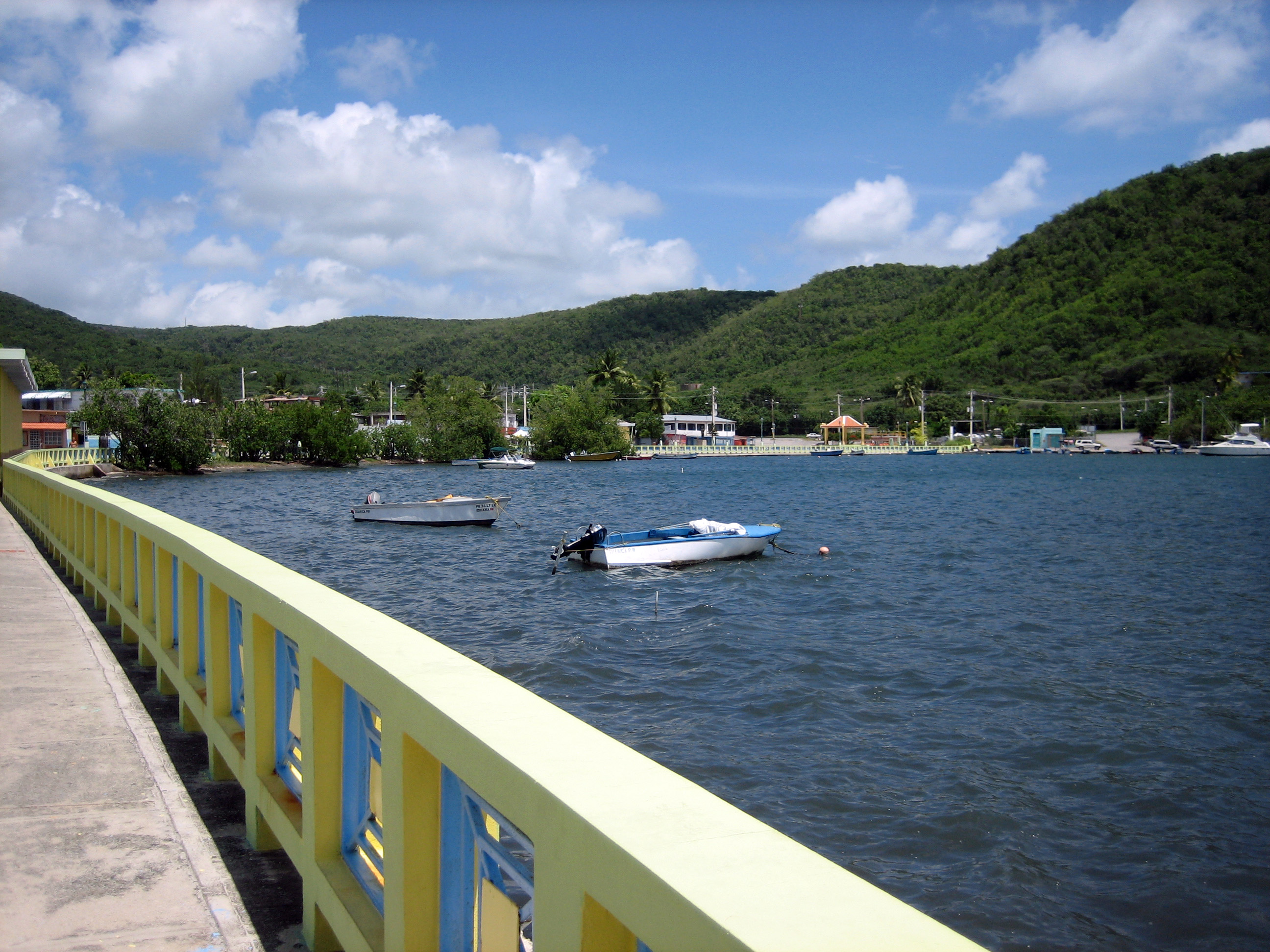
Guánica has not been free of challenges: besides the decline of sugar and the hurricanes, the south of Puerto Rico, including Guánica, was the epicenter of a series of earthquakes in 2020 that caused damage in the region. But the municipality keeps its appeal and its identity. To visit Guánica is to experience the fascinating contrast between the arid dry forest and the crystal-clear waters of the Caribbean, to learn about a key chapter in the island's history and to enjoy the dry, sunny and natural south of Puerto Rico, far from the bustle of the capital.

Guánica and the 2020 earthquakes
The sources document that the south of Puerto Rico, with Guánica as one of the epicenters, suffered a series of earthquakes in 2020 that caused damage. The municipality today combines its natural value (dry forest, cays), its historical weight (1898) and its recovery from these challenges.
Source: https://en.wikipedia.org/wiki/2020_Puerto_Rico_earthquakes

📚 Bibliography

  • Wikipedia (ES) — «Guánica (Puerto Rico)»: https://es.wikipedia.org/wiki/Gu%C3%A1nica_(Puerto_Rico)
  • Wikipedia (EN) — «Guánica, Puerto Rico»: https://en.wikipedia.org/wiki/Gu%C3%A1nica,_Puerto_Rico
  • Wikipedia (EN) — «Guánica State Forest»: https://en.wikipedia.org/wiki/Gu%C3%A1nica_State_Forest
  • Wikipedia (EN) — «Puerto Rico Campaign»: https://en.wikipedia.org/wiki/Puerto_Rico_Campaign
  • Discover Puerto Rico — «Guánica Dry Forest»: https://www.discoverpuertorico.com/profile/bosque-estatal-de-guanica/
  • UNESCO — «Biosphere Reserves»: https://en.unesco.org/biosphere
  • Wikipedia (EN) — «2020 Puerto Rico earthquakes»: https://en.wikipedia.org/wiki/2020_Puerto_Rico_earthquakes
  • Wikipedia (ES) — «Historia de Puerto Rico»: https://es.wikipedia.org/wiki/Historia_de_Puerto_Rico

❓ Frequently asked questions

What is the Guánica Forest and why is it so special?+
It's one of the largest and best-preserved subtropical dry forest reserves in the world, declared a Biosphere Reserve by UNESCO in 1981. It's the 'dry' counterpart to El Yunque: instead of humid jungle, an arid landscape of thorny trees, cacti and rocky soils, with a surprising biodiversity and many endemic species, adapted to drought. Access is free and it's a paradise for birdwatching.
How much does it cost to go to Gilligan's Island and how do I get there?+
Gilligan's Island (Cayo Aurora) is an islet off the coast of Guánica reached by a short DRNA ferry crossing that leaves from the San Jacinto dock, near the Copamarina Beach Resort. The round-trip fare is US$9.59 per person (cooler US$5.58), a 2025 rate subject to change; the cay is closed on Mondays. It's best to call ahead to confirm the schedule, since the operator has little staff.
Can I combine dry forest and beach in the same day?+
Yes, and it's one of Guánica's great draws. Some trails of the Guánica Forest lead directly to turquoise-water beaches and coves (like the Tamarindo area), so you can walk through the arid dry forest and then take a swim in the sea. It's best to do the forest early (because of the heat) and bring water, shade and everything you need, since those coves have no services.
What happened in Guánica in 1898?+
US troops landed in Guánica Bay on July 25, 1898, under the command of General Nelson Miles, beginning the invasion of Puerto Rico during the Spanish-American War. That landing marked the beginning of the end of Spanish rule: that same year, the island passed to the United States by the Treaty of Paris. In Guánica there are monuments commemorating this historical event, which changed the destiny of Puerto Rico.
Is Guánica good for diving?+
Yes, it's one of the best dive spots in Puerto Rico thanks to 'The Wall', a deep underwater wall with excellent visibility and healthy reefs. The Copamarina Dive Center, with PADI 5 Star certification, is the area's go-to operator, with 2-tank trips for about US$130–170 (2025).
How do I get to and around Guánica?+
From San Juan, by car on the PR-52 highway to Ponce and then southern roads, in 1.5 to 2 hours; from Ponce, 30-40 minutes. In Guánica it's best to get around by car, since the forest and beaches are spread out; you get to Gilligan's Island by ferry, and the forest trails are done on foot. Public transport and taxis are limited.
Is there public transport or a bus app in Guánica? How do you pay?+
Guánica has no city bus system or AMA (the Metropolitan Bus Authority only operates in the San Juan metropolitan area), so there's no real-time bus app. The local public transport is the 'carros públicos': shared minibuses that leave from the town plaza when they fill up, daytime only, and are paid in cash to the driver (about US$2–5 per trip, verified July 2026). To get around, the practical option is to rent a car and navigate with Google Maps or Waze (the apps used in Puerto Rico); Uber works poorly in the southwest. You get to Gilligan's Island on the DRNA ferry (US$9.59 round trip, in cash).
What can I combine a visit to Guánica with?+
Guánica combines very well with the rest of the south and southwest of the island: nearby Ponce ('the Pearl of the South', 30-40 minutes away), with its historic center and its museum; and La Parguera, in the neighboring municipality of Lajas, famous for its bioluminescent bay and its cays. Many include it in a southern route. Within Guánica itself, combine the dry forest with a beach day in the cays.
Sources consulted (15)
Still planning?
Explore more destinations in Puerto Rico
See all destinations →
Advertisements
Image credits
Photos from Wikimedia Commons, each under its own licence (CC BY, CC BY-SA or public domain). Open each file to see its author and licence.
Guanica Bay

