Viajá con Gus
HomePuerto RicoGuánica State Forest (Biosphere Reserve)
Guánica State Forest (Biosphere Reserve)
🇵🇷 Puerto Rico · South (Porta Caribe)

Guánica State Forest (Biosphere Reserve)

Jump to what you need
📌Province/State
Municipalities of Guánica and Yauco, southwest Puerto Rico (US)
📌Best time to go
Year-round; early morning because of the heat (dry, sunny climate)
📌Suggested days
Half a day to 1 day
📌Currency
US dollar (USD)
💱 USD exchange rate
Loading rate…
🌤️ Weather in Guánica State Forest (Biosphere Reserve)
Loading weather…

Guánica State Forest is the best-preserved subtropical dry forest in the Caribbean and one of Puerto Rico's natural gems. Declared a Biosphere Reserve by UNESCO, it protects an arid, sunny ecosystem, very different from the tropical, humid image associated with the island: here cacti, twisted-trunk trees, thorny vegetation and a relentless sun over the southwest coast dominate.

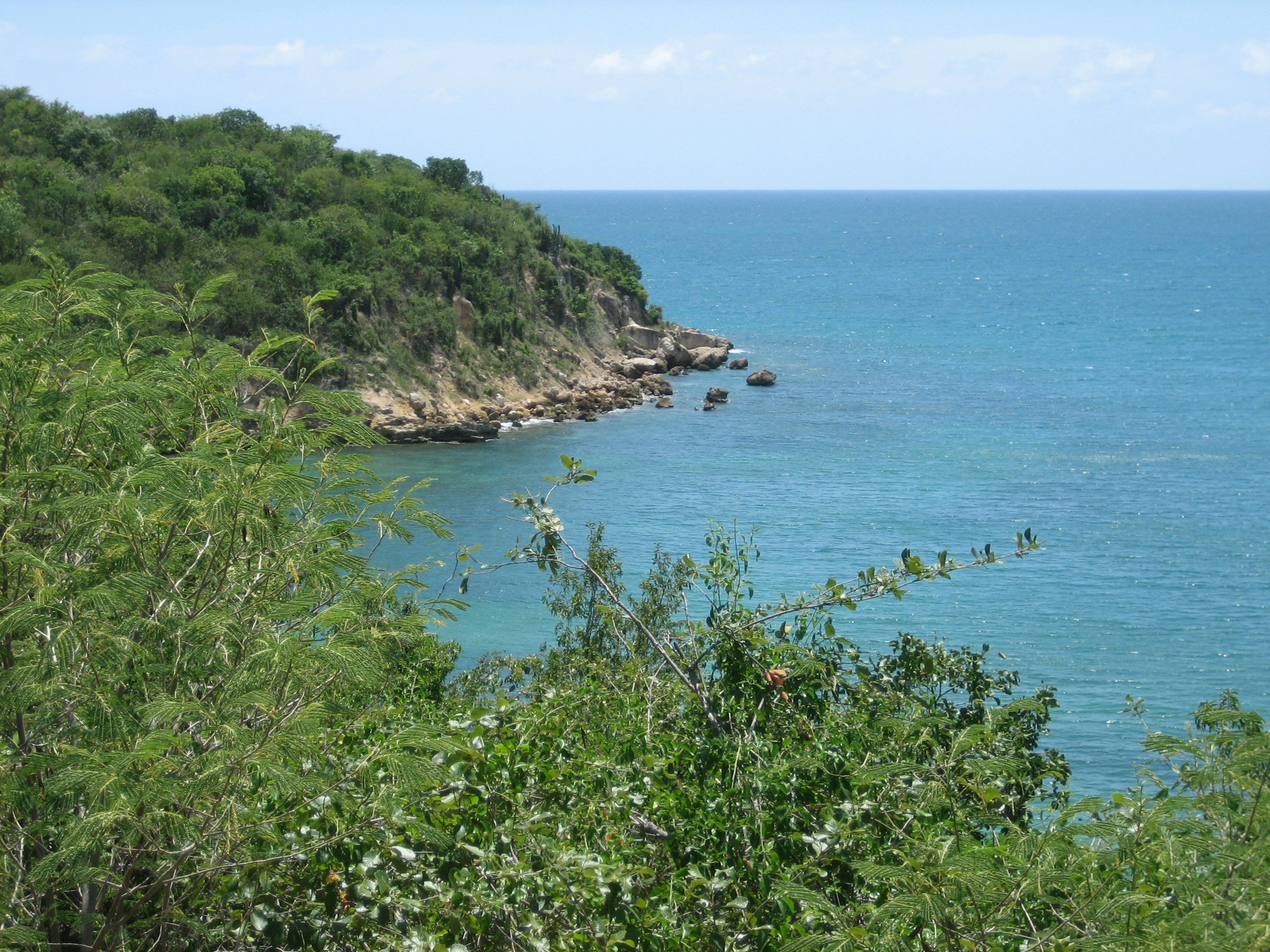
Far from being a barren landscape, this dry forest is home to a surprising and unique biodiversity, with hundreds of plant species and a remarkable variety of birds — among them endemic and threatened species like the Puerto Rican nightjar — plus reptiles and marine life along its coasts. A network of trails crosses the forest to cliffs, lookouts and hidden turquoise-water beaches, like the famous Tamarindo Beach or the Ballena area.

This guide covers the essentials of the forest: its best-known trails, the lookouts over the Caribbean Sea, the beaches and cays that dot its edges, the fauna and flora that make it unique, and how to visit it safely under the southern sun. It's an essential stop for nature lovers traveling through the Porta Caribe region.

📖 History of Guánica State Forest (Biosphere Reserve)

The Guánica dry forest area was inhabited by the Taíno before Spanish colonization and preserves the Indigenous mark in its surroundings. The arid character of southwest Puerto Rico, with scarce rain and lots of sun, gave rise to this subtropical dry forest ecosystem which, protected as a state forest, has reached the present day almost intact. In recognition of its ecological value, UNESCO declared it a Biosphere Reserve, making it an international benchmark for Caribbean dry forest conservation. The full story is on our history page.

Read the full history ↓

🏛️ Guánica State Forest (Biosphere Reserve) is in Guánica

Where United States troops came ashore in 1898 —also said to be the spot where Ponce de León landed in 1508—, a southwestern municipality established in 1914 that is home to the Guánica State Forest, the largest subtropical dry forest reserve in the world and a Unesco biosphere reserve.

Read the history of Guánica →

🗺️ What to see

1
Ballena Trail and Tamarindo Beach
One of the forest's classic trails, descending to the coast and the beautiful Tamarindo Beach.
The Ballena Trail (Vereda Ballena) is one of the most popular routes in the Guánica dry forest. It crosses the characteristic arid vegetation — cacti, thorny twisted-trunk trees and dry scrub — and descends toward the south coast, offering views of the Caribbean Sea and ending at beach and cliff areas. It's a good example of the contrast between the forest's dry landscape and the turquoise waters of the shoreline. One of the most beautiful spots is Tamarindo Beach, a small sandy beach next to the forest, with calm, clear waters, ideal for a rest, a swim or some snorkeling near the shore. The combination of dry forest, rocky coast and beach makes it one of the most representative images of the reserve. The forest trails are well signposted but offer little shade, so it's best to walk early. Getting there: reached via the PR-333 road that runs along the Guánica coast. Best time to go: in the morning, before the strong heat. Tips: bring plenty of water, sunscreen, a cap and closed shoes; there's no shade or services along much of the route.
ℹ️ Distance: Access via the PR-333, Guánica coast · Best time to go: Early morning; little shade along the route · Admission: Free (access to the state forest at no cost, DRNA; verified July 2026) · Duration: 1 to 2 hours
2
Cueva Trail and forest lookouts
Interior forest trails with caves, dry vegetation and lookouts toward the Caribbean.
Beyond the coast, the interior of the Guánica forest is furrowed by a network of trails that let you get to know the dry ecosystem in depth. Trails like the Cueva Trail (Vereda Cueva) and other forest paths cross limestone rock formations, small caves and the dense xerophytic vegetation, in a setting that seems out of this world within the Caribbean. Several of these trails lead to lookouts and high points from which you can take in the Caribbean Sea, the Guánica coast and the nearby cays. The silence of the forest, the birdsong and the landscape of cacti and twisted trees make for an experience very different from the humid rainforest of El Yunque, showing Puerto Rico's surprising diversity of environments. The main access to the interior trail area is usually from the visitor center area and the road up into the forest. Getting there: via the PR-334 from the town of Guánica. Best time to go: early in the morning. Tips: check the trail conditions at the visitor center; hiking shoes, plenty of water and repellent.
ℹ️ Distance: Access via the PR-334 from the town of Guánica · Best time to go: Early in the morning · Admission: Free (state forest trails; check conditions at the visitor center) · Duration: 1 to 3 hours
3
Beaches and cays of the shoreline
Unspoiled beaches, cliffs and cays like Gilligan, accessible from the forest surroundings.
The shoreline associated with the Guánica dry forest hides some of the most beautiful beaches and cays in southern Puerto Rico. Besides Tamarindo Beach, the coast offers coves of crystal-clear water, limestone cliffs and rock formations that contrast with the grayish green of the forest. It's an excellent area for snorkeling, thanks to the clarity of the water and the nearby reefs. Off the Guánica coast lies the famous Cayo Aurora, better known as Gilligan's Island, a small cay of mangroves and turquoise-water channels reached by boat from the Guánica dock. It's a very popular destination among Puerto Ricans for spending the day, swimming in its natural pools and snorkeling, especially on weekends. You can also rent a kayak at the Copamarina Resort to paddle out to the cay on your own. The combination of protected dry forest and Caribbean shoreline makes this area a must for nature and beach. Getting there: the beaches, via the PR-333; to Gilligan, by boat from the Guánica dock (operates Tuesday to Sunday). Best time to go: sunny days; fewer people on weekdays. Tips: confirm the boat schedule (last departures around 5 pm), bring snorkel gear, water and food (limited services on the cay).
ℹ️ Distance: Beaches via the PR-333; to Gilligan by boat from the Guánica dock · Best time to go: Sunny days; fewer people on weekdays · Admission: Beaches free; boat to Gilligan about US$9.59 round trip per person (cash); kayak at Copamarina from US$40/hour (verified July 2026) · Duration: Half a day or more
4
Birdwatching and dry-forest wildlife
One of the best places on the island for birdwatching, including the Puerto Rican nightjar.
The Guánica dry forest is one of the most important destinations in Puerto Rico for birdwatching. Its arid, well-preserved ecosystem hosts a remarkable diversity, with dozens of species, several of them endemic to the island or the Caribbean. The star among birders is the Puerto Rican nightjar, a nocturnal, endemic and threatened bird that finds in this forest one of its main refuges. Beyond the birds, the forest shelters reptiles, like lizards and other species adapted to the dryness, and a flora of great scientific value, with hundreds of plant species, many of them thorny or succulent like cacti. This richness was one of the reasons for its designation as a Biosphere Reserve by UNESCO. Sunrises and sunsets are the best times for wildlife. Getting there: from the forest access points (PR-333 and PR-334). Best time to go: dawn and dusk for birds; the nightjar is nocturnal. Tips: binoculars, a bird guide or local guide; respect the trails and don't disturb the wildlife.
ℹ️ Distance: Forest access points via the PR-333 and PR-334 · Best time to go: Dawn and dusk; the nightjar is nocturnal · Admission: Free (access to the state forest); bird guides at extra cost · Duration: 2 to 4 hours
5
Lookouts and cliffs of the dry coast
High points over the coast where the dry forest drops abruptly toward the Caribbean Sea.
Several stretches of the Guánica forest's coastal trails climb to cliffs and low lookouts from which you can take in the southwest coast, with the Caribbean Sea stretching toward the horizon and, on clear days, the nearby cays in view. These points are ideal at sunset, when the golden light highlights the contrast between the dry vegetation, the limestone rock and the turquoise water. It's a very photogenic landscape, less known than other lookouts on the island, which makes it quieter, especially on weekdays. The walk to the lookouts is usually short but exposed to the sun, so it's best to come prepared. Getting there: from the trails leaving the PR-333, in the coastal area of the forest. Best time to go: sunset, with soft light and less heat. Tips: bring shoes with good grip for the rocks, water and sun protection; be careful with the cliff edges, which don't always have protection.
ℹ️ Distance: Coastal trails leaving the PR-333 · Best time to go: Sunset, with soft light and less heat · Admission: Free (access to the state forest) · Duration: 1 to 2 hours
6
Guánica Lighthouse (ruins) and Fort Caprón
The 19th-century ruined lighthouse at Punta Meseta and an old Spanish fort on the nearby hill.
At Punta Meseta, near the entrance to Guánica Bay, the ruins of the historic Guánica Lighthouse survive, built in 1892 and activated in 1893 to mark the bay's entrance, between the lighthouses of Cabo Rojo and Caja de Muertos Island. The structure, neoclassical in style with an octagonal red-brick tower, became inoperative after an earthquake in 1937 and was permanently deactivated in 1950; today it stands as a historic remnant, no longer functioning. Nearby, on Cerro Caprón, is Fort Caprón and its watchtower, an observation point used during Spanish colonization to keep watch over the bay and the coast. Both sites offer, beyond their historical value, privileged views over Guánica Bay and the dry southwestern shoreline. It's a brief but interesting visit for those looking to round out the forest and the beaches with some of the region's military and maritime history. Getting there: in the Punta Meseta and Cerro Caprón area, near the town of Guánica. Best time to go: during the day, with good visibility for the bay views. Tips: the lighthouse is in ruins and you can't enter the tower; enjoy it from the outside and take advantage of the views of the surroundings.
ℹ️ Distance: Punta Meseta and Cerro Caprón, near the town of Guánica · Best time to go: During the day, with good visibility · Admission: Free (exterior access; ruins not open for entry) · Duration: 1 hour
Advertisements
What nobody tells you

💵 Prices

Tickets

TypePrice
Access to the forest and trailsFree (state forest managed by the DRNA) (verified July 2026)
Boat to Cayo Aurora (Gilligan)About US$9.59 round trip per person (cooler about US$5.58); cash (source: ferry operator / PRDayTrips, verified July 2026)
Kayak at Copamarina Resort (to reach Gilligan on your own)About US$40 for the first hour, US$15 each additional hour (source: Copamarina Beach Resort, verified July 2026)
Parking at the forest access pointsFree at most access points (verified July 2026)
🔄 updated monthlyOfficial / reference values · double-check when buying

Activities and tours

ActivityPriceDurationOperator
Hiking the forest trailsFree (on your own)1-4 h depending on the trailOn your own / DRNA
Snorkeling at Tamarindo Beach and the caysFree on your own (bring your own gear)VariableOn your own
Boat trip to GilliganAbout US$9.59 round trip per person, in cash (verified July 2026)Half a dayBoatmen from the San Jacinto restaurant area (PR-333)
Guided birdwatchingAbout US$40-90 per person (private guides, market estimate, verified July 2026)2-4 hLocal nature guides (confirm)
🔄 updated monthlyOfficial / reference values · double-check when buying
Advertisements

🚌 How to get there and distances

Getting around

ModePriceDurationNotes
Own car / rentalUS$45-80 per day + fuel (gas about US$3.10-3.60/gallon) (verified July 2026)VariableEssential: the forest has no public transport and is reached only via the PR-333 (coast) and PR-334 (interior). There's no city bus or transport app that reaches the forest; you have to come by car. On the highways, tolls are paid with AutoExpreso (usually comes with the rental car)
Boat to Cayo Aurora (Gilligan)About US$9.59 round trip per person; coolers about US$5.58 (source: ferry operator / PRDayTrips, verified July 2026)Short (10-15 min)Leaves from the San Jacinto restaurant area, on the PR-333; first departure between 9 and 10 am and last return around 5 pm, about every 30 min depending on demand. Paid in cash. It's best to call ahead (787-821-4941) or arrive early; sometimes they don't answer the phone
Carros públicosUS$2-8 per trip, in cash (verified July 2026)VariableThey connect the town of Guánica with Yauco, Ponce and other southern towns, but do NOT enter the forest. They leave from the plaza with no fixed schedule; they only work for getting between towns, not to the attractions
On footFreeVariableThe routes inside the forest are on foot, along signposted trails; little shade
🔄 updated monthlyOfficial / reference values · double-check when buying

How to get there

RouteAirlines / operatorsAvg. priceDuration
San Juan → Guánica (highways / PR-2)Car / rentalTolls about US$5-8 + fuelAbout 2 to 2.5 h
Ponce → Guánica (PR-2)Car / rentalFuel about US$5About 30-40 min
Town of Guánica → forest entrance (PR-333/334)CarMinimal fuelAbout 10-15 min
🔄 updated monthlyOfficial / reference values · double-check when buying

🏨 Where to stay

No exact prices: a scale from $ (budget) to $$$$$ (luxury), with 2-3 options per category.

CategoryPriceRecommended options
Oceanfront resort (Copamarina)$$$$$US$180-320 a night; e.g. Copamarina Beach Resort & Spa, with a private beach, kayaks and direct access to the forest; 15-25% promotions for stays of 3+ nights
Rentals and guesthouses$$$$$US$70-140 a night; vacation rental houses and guesthouses in Guánica and along the south coast
Lodging in Ponce (nearby)$$$$$US$100-200 a night; hotels in the city of Ponce, 30-40 minutes away, as a broader base

🍴 Where to eat

TypePriceOptions / signature dish
Seafood and coastal cuisine$$$$$US$12-28 per dish; fresh fish, seafood and fritters at the eateries and kiosks along the Guánica coast
Puerto Rican criollo cuisine$$$$$US$10-20 per dish; mofongo, rice and beans and traditional dishes in the town of Guánica
Resort restaurant (Copamarina)$$$$$US$20-45 per dish; international and signature criollo cuisine with a sea view
Bring supplies$$$$$Inside the forest and on some beaches there are no services; it's best to bring water and food (supermarkets in town from US$5-10 per combo)
Advertisements

📖 History of Guánica State Forest (Biosphere Reserve)

Origins, formation and what the sources say.

The origin of a unique ecosystem: the dry forest

Imagine a corner of Puerto Rico where, instead of the humid jungle and palm trees you'd expect from the Caribbean, what grows are cacti, thorny shrubs and dwarf trees with twisted trunks, under a sun that barely lets up. That place exists, it's less than two hours from San Juan, and it's one of the rarest ecological treasures in the hemisphere: Guánica State Forest, the best-preserved subtropical dry forest in the entire Caribbean and a UNESCO Biosphere Reserve.

Guánica State Forest protects an ecosystem unusual in the tropical image we tend to associate with the Caribbean: a subtropical dry forest. Its existence is explained by the geography of southwest Puerto Rico, one of the most arid areas on the island. The interior mountains, especially the Central Range, intercept much of the moisture arriving from the northeast, so very little rain reaches the south coast. The result is a hot, sunny and dry climate for almost the whole year.

Over millennia, the flora and fauna adapted to those extreme conditions of drought and heat. Thus arose a forest dominated by cacti, trees with twisted trunks and small leaves, thorny plants and vegetation able to survive on little water, on limestone soil. Far from being an impoverished landscape, this dry forest developed a very high and highly specialized biodiversity, with hundreds of plant species and a remarkable variety of birds, reptiles and invertebrates.

What makes Guánica an exceptional case is its degree of conservation: it's considered the best example of subtropical dry forest in the entire Caribbean. That ecological rarity, added to the endemic and threatened species it shelters, made it over time an object of first-rate protection and scientific study.

Taíno, colonization and the Guánica coast

Long before the dry forest was recognized as a scientific reserve, the Guánica region was inhabited by the Taíno, the native people of Puerto Rico (Borikén). Guánica's sheltered bay, the sunny climate and access to the Caribbean Sea offered resources to the Indigenous communities, who lived off fishing, gathering and agriculture adapted to the dry environment of the southwest. The name 'Guánica' itself is of Taíno origin.

After the arrival of the Spanish in the 16th century, the Indigenous population of the whole island was subjugated and decimated, but the Taíno substrate survived in the place names and in the roots of local culture. During the colonial era, the Guánica area developed tied to its bay and to agriculture, especially the sugarcane that dominated much of the south coast. The bay served as a port and anchorage for agricultural production.

That same bay took on an unexpected historical prominence at the end of the 19th century, when it became the point of entry for the US invasion of 1898. The coastal setting of today's dry forest was thus a witness to some of the episodes that changed the course of Puerto Rico, before the region became famous for its natural value.

The Taíno name of Guánica
The sources agree that 'Guánica' is a place name of Taíno origin, which confirms the Indigenous root of the place, though the precise meaning of the name allows for variations depending on the sources.
Source: https://es.wikipedia.org/wiki/Gu%C3%A1nica_(Puerto_Rico)

Protection and UNESCO Biosphere Reserve

As the 20th century advanced, the extraordinary ecological value of the Guánica dry forest began to be officially recognized. The area was protected as a state forest, under the administration of Puerto Rico's natural resources authorities, which made it possible to halt its degradation and conserve one of the few subtropical dry forests that remained relatively intact in the Caribbean.

International recognition came when UNESCO incorporated it into its worldwide network of Biosphere Reserves, within the Man and the Biosphere Programme (MAB). This designation distinguishes places of great ecological value where the aim is to reconcile nature conservation with scientific research and sustainable development. Guánica thus came to figure among the most prestigious natural spaces in the Caribbean.

The forest is home to numerous species of plants and birds, several endemic or threatened, among which the Puerto Rican nightjar stands out, a nocturnal bird that finds here one of its main refuges. Today, managed as a state forest and biosphere reserve, Guánica combines the protection of its fragile ecosystem with responsible public use through its trails, beaches and lookouts, being a symbol of the conservation of the Caribbean dry forest.

1898: Guánica Bay and the US invasion

Few corners of Puerto Rico carry such a specific weight in the island's political history as Guánica Bay, in whose surroundings the dry forest stretches today. On July 25, 1898, amid the Spanish-American War, US troops under the command of General Nelson A. Miles landed in this very bay, beginning the military campaign that in a few weeks put an end to more than four centuries of Spanish sovereignty over Puerto Rico.

The choice of Guánica as the landing point was not accidental: its natural, sheltered, deep-water bay offered favorable conditions for landing troops and supplies, and the scant Spanish defense in that southwestern area made the operation easier. The event had consequences that reach to this day, since it marked the beginning of the period in which Puerto Rico became a territory under US sovereignty, a political, economic and cultural transformation that reshaped the destiny of the whole island.

Today, the coast that was the scene of that landing coexists with the protected dry forest and its trails toward the sea, so that walking toward Tamarindo Beach or the Ballena lookouts is, in a sense, traveling through a landscape that combines historical memory and nature. Guánica is thus a place where the exceptional ecology of the dry forest and one of the most decisive episodes of Puerto Rican political history share the same coastal territory.

The 1898 landing at Guánica
Historical sources agree that the landing of US troops in Guánica Bay, on July 25, 1898, marked the beginning of the campaign that put an end to Spanish sovereignty over Puerto Rico. It's one of the most documented and significant historical events linked to the region.
Source: https://es.wikipedia.org/wiki/Gu%C3%A1nica_(Puerto_Rico)

The nightjar and the secret life of the dry forest

If the Guánica dry forest came to be a Biosphere Reserve, it wasn't only for its rarity as a landscape, but for what lives within it. In barely a few thousand hectares, this forest concentrates an astonishing biodiversity: nearly 700 plant species have been counted — many of them endemic or endangered — and almost half of all the land bird species of Puerto Rico. For a seemingly hostile ecosystem, made of thorns and thirst, it's an extraordinary density of life.

The symbol of that richness is a small, discreet, nocturnal bird: the Puerto Rican nightjar (Antrostomus noctitherus), a relative of the whip-poor-will that came close to disappearing. For much of the 20th century it was given up as extinct, until it was rediscovered in 1961 precisely in the dry forest of the southwest. Guánica today is home to one of the most important populations of this threatened species, whose call — a 'guá-bai-ro' repeated in the dark — gave the bird its name and is one of the most sought-after sounds by the birdwatchers who come from all over the world.

Alongside the nightjar live reptiles adapted to drought, bats, and other emblematic birds like the gray kingbird, the Adelaide's warbler and numerous migratory species that use the forest as a winter refuge. The vegetation, dominated by guaiacum, black olive and dozens of cacti and thorny shrubs, many of them centuries old, forms a mosaic that scientists study as a model of resilience against drought. Walking its trails at dawn or dusk — the best times for wildlife — is to glimpse that secret life that made Guánica a natural laboratory of international fame.

The rediscovery of the nightjar
The sources agree that the Puerto Rican nightjar, considered extinct for decades, was rediscovered in the mid-20th century in the southwestern dry forest, and that Guánica is today one of its main refuges. The exact population and plant-species figures may vary slightly between scientific sources.
Source: https://en.wikipedia.org/wiki/Puerto_Rican_nightjar

📚 Bibliography

  • Wikipedia (ES) — «Bosque Estatal de Guánica»: https://es.wikipedia.org/wiki/Bosque_Estatal_de_Gu%C3%A1nica
  • Wikipedia (EN) — «Guánica State Forest»: https://en.wikipedia.org/wiki/Gu%C3%A1nica_State_Forest
  • Wikipedia (ES) — «Guánica (Puerto Rico)»: https://es.wikipedia.org/wiki/Gu%C3%A1nica_(Puerto_Rico)
  • Wikipedia (EN) — «Guánica, Puerto Rico»: https://en.wikipedia.org/wiki/Gu%C3%A1nica,_Puerto_Rico
  • Unesco — Reserva de la Biósfera de Guánica: https://en.unesco.org/biosphere/lac/guanica
  • Departamento de Recursos Naturales y Ambientales de Puerto Rico (DRNA): https://www.drna.pr.gov/
  • Wikipedia (ES) — «Historia de Puerto Rico»: https://es.wikipedia.org/wiki/Historia_de_Puerto_Rico
  • Wikipedia (EN) — «Puerto Rican nightjar»: https://en.wikipedia.org/wiki/Puerto_Rican_nightjar
  • Discover Puerto Rico — «Bosque Estatal de Guánica»: https://www.discoverpuertorico.com/profile/bosque-estatal-de-guanica-guanica-dry-forest/8073
  • EnciclopediaPR — «Municipio de Guánica»: https://enciclopediapr.org/content/municipio-de-guanica/

❓ Frequently asked questions

What's special about the Guánica forest?+
It's the best-preserved subtropical dry forest in the Caribbean, declared a Biosphere Reserve by UNESCO. It shows an arid, sunny side of Puerto Rico, with cacti and thorny vegetation, a unique biodiversity (including the endemic nightjar) and trails that descend to turquoise beaches like Tamarindo.
How do you get to the forest?+
By car, which is practically essential. It's reached via the PR-333, which runs along the coast, and the PR-334, which climbs into the interior of the forest from the town of Guánica. From Ponce it's about 30-40 minutes; from San Juan, around 2 to 2.5 hours.
How much does it cost to enter the forest?+
Access to Guánica State Forest is free, since it's a protected area managed by the DRNA. You only pay if you book extra activities, like the boat to Cayo Aurora (Gilligan), which is around US$8-12 round trip per person, or kayak rental at the Copamarina Resort.
Can you go to the beach in the forest?+
Yes. The forest's coast has beaches and coves like Tamarindo Beach, with calm, clear waters, ideal for swimming and snorkeling. Off the coast there's also Cayo Aurora (Gilligan's Island), reached by boat from the Guánica dock (operates Tuesday to Sunday) and very popular for spending the day.
What should you bring to visit it?+
Plenty of water, sunscreen, a cap or hat and closed shoes, because the forest offers little shade and the southern sun is very strong. It's best to walk early in the morning. If you're going to watch birds, bring binoculars; for the cays and beaches, snorkel gear.
Is it good for birdwatching?+
It's one of the best places in Puerto Rico for birdwatching, with dozens of species, several endemic or threatened. The most sought-after is the Puerto Rican nightjar, a nocturnal endemic bird that has one of its main refuges here. Dawn and dusk are the best times.
When is it best to visit?+
It can be visited year-round, since the southwest is dry and sunny. It's ideal to go early in the morning to avoid the most intense heat, especially on the shadeless trails. For wildlife, dawn and dusk are the best times.
Is there public transport to the forest? How do you pay?+
No. Guánica State Forest has no bus or public transport, and no transport app covers it (the official bus app, Transit, only works for San Juan). The only way to get there is by your own car, a rental or a tour, via the PR-333 and PR-334 roads. The carros públicos connect the town of Guánica with Yauco and Ponce (paid in cash, US$2-8), but they don't enter the forest. For the boat to Cayo Aurora (Gilligan) you pay in cash, about US$9.59 round trip. On the highways, tolls are paid with AutoExpreso, not cash (verified July 2026).
Sources consulted (16)
Still planning?
Explore more destinations in Puerto Rico
See all destinations →
Advertisements
Image credits
Photos from Wikimedia Commons, each under its own licence (CC BY, CC BY-SA or public domain). Open each file to see its author and licence.
Guánica State forest

