Viajá con Gus
HomeHondurasCholuteca
Choluteca
🇭🇳 Honduras · The South and the Gulf of Fonseca

Choluteca

📌Department
Choluteca is the capital of the department of the same name, in the south of Honduras, on the hot plain that descends toward the Gulf of Fonseca and the Pacific Ocean. It's the main city of the country's south and the fourth or fifth most populous in Honduras, with a little over 100,000 inhabitants in the urban core. It's crossed by the Choluteca River and by the Pan-American Highway (CA-1), which makes it a key crossroads toward Nicaragua and El Salvador. The city keeps a historic center of colonial roots, with its central park, the Church of the Immaculate Conception and adobe mansions, amid one of the hottest climates in the country
📌Service city
Choluteca itself is the service city for the whole Honduran south: it concentrates hospitals, banks, supermarkets, hotels, a bus terminal and commerce. It has no active commercial airport; the most common way to arrive is by road from Tegucigalpa (about 2.5 to 3 hours via the CA-1, depending on a stop in San Lorenzo) or from the borders of Guasaule (Nicaragua) and El Amatillo (El Salvador). It's the natural base for touring the south: the Pacific beaches (Cedeño, Punta Ratón), the Gulf of Fonseca, Amapala on Isla del Tigre and the mangroves of the area
📌Best time to go
The south of Honduras is the hottest and driest region in the country, with two marked seasons. The dry season (summer), from November to April, offers sunny days, clear skies and intense heat: it's the best time for beaches, mangroves and tours, though you have to hydrate and protect yourself from the sun. The rainy season (winter), from May to October, brings strong afternoon downpours, greener landscapes and roads that are sometimes tricky in rural areas. In any season it's best to get up early to make the most of the cooler hours
📌Suggested days
With 1 day you can tour the historic center of Choluteca: the central park, the Cathedral of the Immaculate Conception, the Choluteca suspension bridge and the market. With 2 to 3 days you can add a getaway to the Pacific beaches (Cedeño or Punta Ratón) and to the mangroves and estuaries of the Gulf of Fonseca, and even a crossing to San Lorenzo or Amapala (Isla del Tigre). For those passing through between Tegucigalpa and the borders, it's usually a half-day stop or an overnight transit stay
💱 Cambio de USD
Loading rate…
🌤️ Clima en Choluteca
Loading weather…

Choluteca is the great city of southern Honduras, a hot and dusty town spread across the plain that descends toward the Gulf of Fonseca and the Pacific. Crossed by the river that gives it its name and by the Pan-American Highway, it's a crossroads between Honduras, Nicaragua and El Salvador, and for centuries an unavoidable stopping point in the Central American south. Whoever travels overland between Tegucigalpa and the southern borders passes through Choluteca sooner or later.

Beyond its role as a commercial hub, the city keeps a historic center of colonial roots worth exploring at leisure: the central park, the Church of the Immaculate Conception, adobe mansions and streets that recall one of the oldest towns in the country. It's also the gateway to the deep south: the dark-sand Pacific beaches, the mangroves and estuaries of the Gulf of Fonseca, the world of the fishermen and salt workers, and the fiery sunsets over the sea.

This guide covers the essentials of Choluteca with a practical eye: what to see in its center, how to escape to the beaches and mangroves of the south, how to get around and how to cope with the heat, which is the great protagonist of the region. It's not a postcard tourist city, but it's the ideal base for discovering a less-traveled, authentic corner of Honduras deeply tied to the Pacific.

📖 History of Choluteca

Choluteca is one of the oldest towns in Honduras. Its name comes from the Choluteca or Chorotega, a people of Mesoamerican origin who inhabited the Pacific region before the arrival of the Spanish. The area was settled in pre-Hispanic times by groups of Chorotega affiliation and, to the south, by communities linked to the Nicarao. The Spanish arrived in the Honduran south in the 16th century, and the founding of the town of Choluteca (originally known as Xerez de la Frontera de Choluteca) is usually placed around the middle of that century. Its location, on the road that linked the provinces of Honduras and Nicaragua and near the Gulf of Fonseca, gave it importance as a passage and cattle-trade point. During the colonial era it was the head of a broad southern territory. After Central American independence in 1821, Choluteca established itself as the main urban center of southern Honduras and, over time, the capital of its department. In recent decades, its history was marked by Hurricane Mitch in 1998, which caused the catastrophic overflow of the Choluteca River and enormous damage throughout the region, as well as by subsequent reconstruction projects. Today the city keeps its character as the commercial capital of the south, with a historic center that preserves the colonial imprint. The full story is on our history page.

Read the full history →

🏛️ Choluteca is in Choluteca

The hot south of Honduras, the 'Sultana of the South' on the Gulf of Fonseca: land of the Chorotega and of one of the oldest colonial towns in the country, birthplace of the founding father José Cecilio del Valle, of shrimp, melons and the relentless sun of the 'dry corridor'.

Read the history of Choluteca →

🗺️ What to see

1
Historic center and Central Park
The colonial heart of Choluteca, with its tree-lined central park, the cathedral and adobe mansions around it.
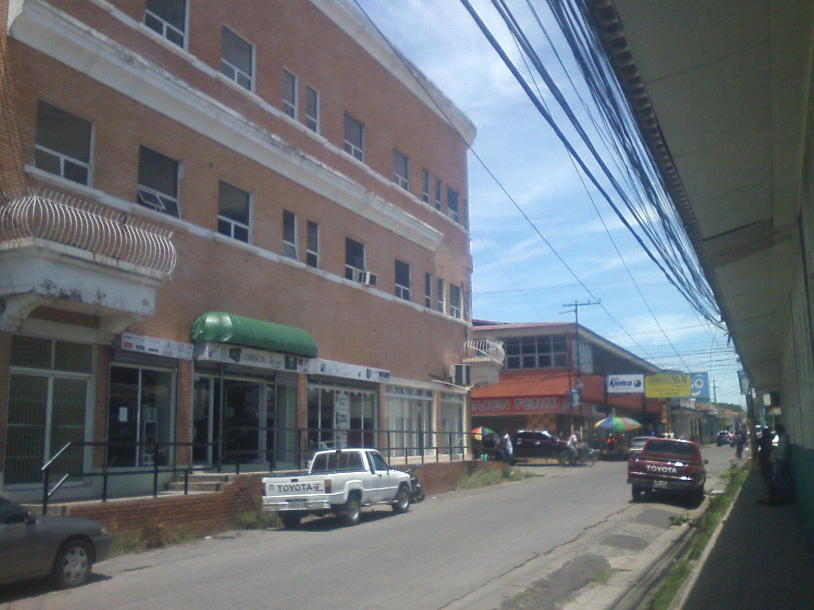
The historic center of Choluteca is where the city's soul beats and where its colonial heritage is concentrated. Its heart is the Central Park, a tree-lined square with benches, gazebos and lots of everyday life, surrounded by the city's most representative buildings: the Church of the Immaculate Conception, the town hall and houses of traditional one- and two-story architecture, many of them of adobe and tile, with corridors and inner courtyards. Walking the center is the best way to capture the atmosphere of the south: the heat that invites you to seek the shade, the vendors, the old mansions and the unhurried rhythm of one of the oldest towns in Honduras. Choluteca was a key point on the colonial road between Honduras and Nicaragua, and that past can be felt in its streets. Some historic houses, like the well-known 'Casa de la Cultura' and former residences of notable families, recall the town's importance in colonial times. The center is also the most practical area for the traveler: around the park and the neighboring streets are banks, shops, diners and the market, worth a look to see and try the local cuisine of the south. It's a good starting point for exploring the most interesting parts of the city on foot. How to get there: the center is fully walkable; reached on foot from most hotels or by taxi/mototaxi from the terminal. Best time to go: early in the morning or at dusk, to avoid the hottest hours. Tips: bring water, sunscreen and a hat; the southern sun is intense. At night, as in any city, move around the busy streets and return by taxi.
ℹ️ Distance: City center; walkable or by taxi/mototaxi from the terminal · Best time to go: Early morning or at sunset (avoid the midday heat) · Entry: Free (public space) · Duration: 1 to 2 hours
2
Church of the Immaculate Conception (Choluteca Cathedral)
The city's most emblematic colonial church, on the Central Park, with its traditional white façade.
The Church of the Immaculate Conception is the most important religious monument in Choluteca and one of the testimonies of its colonial past. It stands facing the Central Park and, with its whitewashed façade, its towers and its sober colonial-inspired architecture, presides over the heart of the city. It's one of those churches of the Honduran south that combine the solidity of old walls with the simplicity of provincial churches. The church is dedicated to the Immaculate Conception, the city's patron saint, and is the center of local religious life, especially during the patron-saint festivities, when it fills with worshippers, music and celebrations. Its interior, of austere lines, invites a moment of calm and coolness, a welcome relief in such a hot city. Visiting the church combines naturally with a stroll through the Central Park and the historic center, since everything is a few steps away. It's part of the classic tour of the old quarter of Choluteca and a good point for understanding the traditional, Catholic character of the region. How to get there: right downtown, facing the Central Park; reached on foot. Best time to go: in the morning or at dusk; during the patron-saint festivities the atmosphere is very lively. Tips: respect the Mass hours and suitable dress to enter; take advantage of the park's shade and the church's coolness during the hot hours.
ℹ️ Distance: Facing the Central Park, center of Choluteca (on foot) · Best time to go: Morning or dusk; patron-saint festivities very lively · Entry: Free access (respect worship hours) · Duration: 30 minutes
3
Choluteca suspension bridge (Old Bridge)
The historic suspension bridge over the Choluteca River, a symbol of the city and famous after Hurricane Mitch.
The Choluteca suspension bridge, also known as the Old Bridge, is one of the city's most recognizable symbols. Spanning the Choluteca River, it's a historic structure that for a long time was a fundamental crossing connecting the city and the region. Its silhouette of cables and towers, reflected in the river, is one of the classic images of the area. The bridge gained international notoriety as a result of Hurricane Mitch in 1998: during that disaster, the Choluteca River overflowed catastrophically and changed its course, and the image of a nearby modern bridge left 'with no river beneath it' due to the shift of the riverbed became famous. The old suspension bridge, for its part, withstood as a witness to the force of nature and to the city's story of resilience in the face of floods. Today the bridge and the riverbanks are part of the urban landscape and of local memory. It's an interesting spot for taking photos, walking and understanding the —sometimes dramatic— relationship between Choluteca and its river. Combined with the historic center, it rounds out a visit to the city. How to get there: near the city center, over the Choluteca River; on foot or by mototaxi. Best time to go: during the day, in good light; avoid the hottest hours. Tips: for safety, walk during the day and through the busy areas; check locally the condition and access to the bridge, which may vary.
ℹ️ Distance: Over the Choluteca River, near the center (on foot or mototaxi) · Best time to go: During the day, in good light; avoid midday · Entry: Free (public space) · Duration: 30 to 45 minutes
4
Cedeño Beach
The most popular beach in southern Honduras, of dark volcanic sand, on the Pacific and the Gulf of Fonseca.
Cedeño is the best-known and busiest beach in southern Honduras, and the classic seaside getaway from Choluteca. It's a long stretch of dark sand, almost black because of its volcanic origin, open to the Pacific Ocean in the Gulf of Fonseca area. It's a popular beach much frequented by southern Hondurans, especially on weekends, holidays and Holy Week, when it fills with people and atmosphere. The beach has a simple, local character: champas (food shacks) serving fried fish, seafood and cold drinks, hammocks in the shade and a warm Pacific sea. It's not a white-sand Caribbean postcard beach, but a town beach, hot and authentic, ideal for experiencing the atmosphere of the south, eating fresh seafood and watching the sunset over the ocean. The sunrises and sunsets over the Pacific are usually spectacular. Cedeño is also a gateway to the world of the fishermen and to the nearby estuaries and mangroves of the Gulf of Fonseca, which can be toured by boat from the area. Keep in mind that it's a beach with waves and currents in some stretches, so swim with caution. How to get there: from Choluteca, by road to the south (car, taxi or local bus); confirm schedules and road conditions. Best time to go: dry season (November to April) for guaranteed sun; avoid major holidays if you're after quiet. Tips: bring sunscreen, a hat and water; watch the waves when swimming; carry little cash and mind your belongings on busy days.
ℹ️ Distance: Pacific coast south of Choluteca (car, taxi or bus) · Best time to go: Dry season; weekdays for more quiet · Entry: Free (public beach); spending at champas L 100-250 per person (2025) · Duration: Half a day to a full day
5
Punta Ratón and the mangroves of the Gulf of Fonseca
A dark-sand beach and an area of mangroves and estuaries, famous for the release of sea turtles.
Punta Ratón is another of the beaches of the Honduran south, quieter and more picturesque than Cedeño, in the coastal area of the Gulf of Fonseca. It's a strip of dark sand beside an environment of mangroves and estuaries, characteristic of the Honduran Pacific shore. The atmosphere is that of a fishing community, with food champas, boats and a way of life tied to the sea and the tides. What has made Punta Ratón famous is its link with sea turtles: the area is a nesting site for the olive ridley turtle (and other species), and traditionally conservation activities and the famous release of hatchlings (neonates) into the sea are carried out there, which at certain times of year draws visitors. It's best to check locally about the dates and rules of these activities, always ensuring they're done responsibly and respectfully toward the wildlife. The mangroves and estuaries of the Gulf of Fonseca, which can be toured by boat from several communities in the area, are a very rich ecosystem: habitat for birds, crustaceans and fish, and the basis of the south's artisanal fishing and salt and shrimp production. A boat trip through the channels among mangroves is a different experience very tied to local life. How to get there: from Choluteca by road toward the coast (car, taxi or local transport); check road conditions and schedules. Best time to go: dry season; for the turtles, check the nesting and release season. Tips: bring sunscreen, repellent and water; hire local boats and guides for the mangroves; respect the turtle conservation rules.
ℹ️ Distance: Gulf of Fonseca coast, south of Choluteca (car/taxi/local transport) · Best time to go: Dry season; turtle nesting season (check locally) · Entry: Free (public beach); mangrove boat trip US$ 15-30 per group (2025, negotiable) · Duration: Half a day to a full day
6
Municipal Market and southern cuisine
The bustling Choluteca market, ideal for getting to know the flavors and products of the Honduran south.
The Municipal Market of Choluteca is where you see and taste the south of Honduras in its purest state. It's a bustling and hot market, full of stalls of tropical fruits and vegetables, grains, fresh fish and seafood brought in from the Pacific, meats, prepared food, crafts and objects of all kinds. Touring it is to immerse yourself in the region's everyday life and its economy, closely tied to farming, cattle ranching, fishing and salt. It's also a good place to discover the south's cuisine: fish and seafood are the protagonists (seafood soups, fried fish, ceviches), along with traditional Honduran dishes like baleadas, tamales and budget-diner food. Trying the food at the market stalls or nearby diners is an authentic and cheap experience. Like any big market, it's best to tour it with common sense: carry little cash on show, mind your belongings and move around the busy areas. It's a visit that complements the tour of the historic center very well and helps you understand the commercial character of Choluteca, capital of the south. How to get there: downtown; on foot or by mototaxi. Best time to go: in the morning, when the market is most active and the products are fresh. Tips: go early because of the heat, bring cash in small bills, mind your things and go ahead and try the local seafood.
ℹ️ Distance: Center of Choluteca (on foot or mototaxi) · Best time to go: In the morning (most activity and fresh products) · Entry: Free (public space) · Duration: 1 hour
What nobody tells you

💵 Prices

Tickets

TypePrice
Historic center and Central ParkFree (public space)
Church of the Immaculate ConceptionFree access (respect worship hours)
Choluteca suspension bridgeFree (public space)
Cedeño BeachFree (public beach); spending at champas L 100-250 per person (2025)
Punta Ratón (beach)Free (public beach)
Boat trip through the mangroves of the Gulf of FonsecaUS$ 15-30 per group (2025, negotiable with local boatmen)
Municipal MarketFree (public space)
🔄 updated monthlyOfficial / reference values · double-check when buying

Activities and tours

ActivityPriceDurationOperator
Walking tour of the historic center and Central ParkFree1-2 hSelf-guided tour
Beach day at Cedeño (sun, seafood and sunset)Free access; L 100-250 of spending (2025)Half a day to a full dayLocal transport and beach champas
Boat trip through the mangroves and estuaries of the Gulf of FonsecaUS$ 15-30 per group (2025)Half a dayBoatmen and community guides of the area
Visit to Punta Ratón and sea-turtle activities (seasonal)Free or voluntary donation to conservation projects (2025)Half a dayLocal communities and conservation projects
Culinary tour of the market and southern dinersUS$ 3-10 per meal (2025)1-2 hLocal diners and stalls
🔄 updated monthlyOfficial / reference values · double-check when buying

🚌 How to get there and distances

Getting around

ModePriceDurationNotes
Mototaxi (tuk-tuk)L 20-40 per short trip within the urban core (fuente: tarifas locales, verificado julio 2026)VariableThe most used means of getting around the city and to the market or the terminal. Cheap and practical for short distances. It's ALWAYS paid in cash (lempiras), there's no payment app or card; it's best to bring small bills
TaxiL 50-100 depending on the trip within the city (fuente: tarifas locales, verificado julio 2026)VariableFor longer trips or outings toward the coast. They don't use a meter: agree the fare before getting in. Payment in cash. There's no Uber or ride apps like InDrive with reliable coverage in Choluteca
City buses and rapiditosL 10-20 urban fare, paid in cash to the driver (fuente: tarifas locales del sur, verificado julio 2026)VariableBuses and minibuses (rapiditos) that connect neighborhoods and nearby communities. You pay in cash on boarding: in the south of Honduras there's NO prepaid card or QR payment (the prepaid-card project is being tested only in Tegucigalpa and San Pedro Sula, not here). At night it's best to prefer a taxi
Intercity buses (to beaches and southern communities)L 40-80 depending on destination, in cash (fuente: terminal de Choluteca, verificado julio 2026)VariableFrom the terminal, buses leave for Cedeño, Punta Ratón, San Lorenzo and other southern localities. Confirm schedules, which can be limited and with the last departure in mid-afternoon
Transport apps and mapsNo cost (data usage)Moovit has NO route coverage in Choluteca or in the south of Honduras (it only works partially in Tegucigalpa and San Pedro Sula), so it's no use for seeing the colectivo route here. Google Maps does help for getting your bearings and calculating distances by car, but it doesn't have southern bus schedules. The most reliable thing is to ask at the terminal and the local people (fuente: cobertura de Moovit, verificado julio 2026)
🔄 updated monthlyOfficial / reference values · double-check when buying

How to get there

RouteAirlines / operatorsAvg. priceDuration
Tegucigalpa → Choluteca (Pan-American Highway CA-1)Mi Esperanza del Sur (direct buses), rapiditos/brujosL 115-160 (approx. US$ 5-7); paid in cash at the terminal (fuente: Mi Esperanza del Sur / terminal de Comayagüela, verificado julio 2026)About 2.5 to 3 h (about 140 km, via San Lorenzo)
San Lorenzo → Choluteca (CA-1)Southern buses and rapiditosAbout L 30-50 (2025)About 30 to 45 min
Guasaule border (Nicaragua) → CholutecaInternational and local busesAbout L 50-90 (2025)About 45 min to 1 h
El Amatillo border (El Salvador) → CholutecaInternational and local busesAbout L 80-130 (2025)About 1.5 to 2 h
Choluteca → Pacific beaches (Cedeño, Punta Ratón)Local buses and taxisL 40-80 by bus; L 300-500 by taxi (2025)About 1 to 1.5 h depending on destination
🔄 updated monthlyOfficial / reference values · double-check when buying

🏨 Where to stay

No exact prices: a scale from $ (budget) to $$$$$ (luxury), with 2-3 options per category.

CategoryPriceRecommended options
Chain and boutique hotels$$$$$US$ 55-90 a night; e.g. Hotel Boutique Casa D' Luna, Hotel Hacienda Gualiqueme, with air conditioning (essential because of the heat), pool and restaurant, near the center or on the main roads
Business hotels and lodgings$$$$$US$ 34-55 a night; e.g. HM Hotel, mid-range hotels aimed at business travelers and those passing through on the Pan-American Highway
Budget / backpacker lodging$$$$$US$ 15-30 a night; budget options near the terminal and the center, chosen by travelers on a tight budget or just stopping over. Check that they have air conditioning or a good fan because of the hot climate
Lodging on the coast (Cedeño and beach area)$$$$$US$ 20-40 a night; simple lodgings and seafront cabins, of local character, for those who want to stay near the beach. Limited offering; it's best to book or check in advance

🍴 Where to eat

TypePriceOptions / signature dish
Pacific seafood and fish$$$$$US$ 8-18 per dish; fried fish, seafood soups, shrimp and ceviches, with shrimp from the Gulf of Fonseca as the star product. Enjoyed at restaurants in the city and, above all, at the champas of beaches like Cedeño
Typical Honduran food$$$$$US$ 3-8 per dish; baleadas, tajadas, grilled meat, chicken with tajadas, tamales and daily specials at diners and typical eateries, budget options very present in the center and the market
Restaurants and fast food on the Pan-American Highway$$$$$US$ 5-12 per dish; restaurants, fast-food chains and cafés on the main roads, practical for travelers passing through on the CA-1
Champas and beach food$$$$$US$ 5-14 per dish; at Cedeño and Punta Ratón, the food shacks (champas) serve fresh fish and seafood right on the beach, with cold drinks and a local atmosphere

❓ Frequently asked questions

Is it worth stopping in Choluteca?+
Choluteca is not a postcard tourist destination, but it's the ideal base for getting to know the south of Honduras and a convenient stop for those traveling between Tegucigalpa and the borders of Nicaragua or El Salvador. It has a pleasant colonial historic center, it's close to the Pacific beaches (Cedeño, Punta Ratón) and the mangroves of the Gulf of Fonseca, and it offers good seafood cuisine. For many travelers it's a half-day or overnight stop, combinable with the coast.
How much does the bus from Tegucigalpa to Choluteca cost?+
The ticket on a direct bus (Mi Esperanza del Sur) or on the so-called 'rapiditos' costs between L 115 and 130 (approx. US$ 5-9, 2025), with departures almost every hour from the Comayagüela terminal, between roughly 5:00 and 16:00. The trip takes between 2.5 and 3 hours.
What's the best time to visit southern Honduras?+
The dry season, from November to April, is the best for beaches and tours: sunny days and roads in good condition, though very hot. The rainy season (May to October) brings afternoon downpours and greener landscapes, but also trickier rural roads. In any season, the south is the hottest region in the country, so it's best to get up early and protect yourself from the sun.
How do I get to the beaches from Choluteca?+
The Pacific beaches like Cedeño and Punta Ratón are reached by road from Choluteca, by car, taxi (L 300-500) or local buses (L 40-80, with limited schedules, best to confirm). Cedeño is the most popular and busy; Punta Ratón is quieter and associated with the mangroves and the sea turtles. Count on about an hour or a bit more of travel depending on the destination.
Is it safe to travel to Choluteca and the south?+
As in the rest of Honduras, it's best to take basic precautions: move around during the day through busy areas, carry little cash on show, mind your phone and belongings, and use a taxi at night. The center and the tourist areas are toured well with common sense. Always check up-to-date local information about routes and neighborhoods before getting around.
What to eat in Choluteca?+
The south is seafood country: fried fish, seafood soups, ceviches and, above all, shrimp from the Gulf of Fonseca. To that are added the Honduran classics like baleadas, tajadas and grilled meat. The most authentic thing is to eat fresh seafood at the champas of Cedeño beach (US$ 8-18 per dish) or try the food from the market and the center's diners (US$ 3-8).
Can you see sea turtles in the south?+
Yes. The Punta Ratón area and other beaches of the Gulf of Fonseca are nesting sites for sea turtles (like the olive ridley), and traditionally conservation activities and hatchling releases are carried out there at certain times of year. You have to check locally about the dates and rules, and always take part responsibly and respectfully toward the wildlife.
How do you pay for the bus in Choluteca and is there an app to see the colectivo?+
Transport in Choluteca and throughout the south of Honduras is paid in CASH (lempiras), both the city buses (L 10-20) and the rapiditos, mototaxis and taxis. There's no prepaid card or QR payment: the prepaid-card system being implemented in Honduras started only in Tegucigalpa and San Pedro Sula, it doesn't reach the south. To see the colectivo route in real time there's no reliable app —Moovit doesn't cover Choluteca—; the most practical thing is to get your bearings with Google Maps for distances and ask at the terminal about schedules (verified July 2026).
Sources consulted (13)
Still planning?
Explore more destinations in Honduras
See all destinations →